Share now
Map of Sanghar

Map of Sanghar District

Sindh Districts
- Karachi District Profile
- Badin District Profile
- Dadu District Profile
- Ghotki District Profile
- Hyderabad District Profile
- Jacobabad District Profile
- Jamshoro District Profile
- Kashmore District Profile
- Khairpur District Profile
- Larkana District Profile
- Matiari District Profile
- Mirpurkhas District Profile
- Naushero FerozeDistrict Profile
- Sanghar District Profile
- Shahdadkot District Profile
- Shaheed Benazirabad District Profile
- Shikarpur District Profile
- Sukkhur District Profile
- Tando AllahYar District Profile
- Tando Mohammad Khan District Profile
- Tharparkar District Profile
- Thatta-Sajawal District Profile
- Umerkot District Profile
Also visit: Punjab, Balochistan, Khyber Pakhtunkhwa
Sanghar District Profile
Introduction/Geographical Location; Sanghar District
Sanghar is one of the largest districts, in terms of area, of Sindh, and is located between 25° 29Ꞌ 42” to 26° 28Ꞌ 1” North latitudes and 68° 28Ꞌ 18” to 70° 12Ꞌ 49” East longitudes. It is surrounded by Khairpur and Nawabshah districts in the North and Northwest, Umerkot, Mirpurkas, and Tando Allahyar districts in the South, Matiari district in the West, Hyderabad district in the Southwest and Jaisalmir and Jodhpur districts of India in the East.
The district is named after its capital town, Sanghar, and was created from Tharparkar (Thar and Parkar district at that time) and Nawabshah districts in 1953.
Sanghar District at a Glance
| Name of District | Sanghar District | ||
| District Capital | Sanghar Town | ||
| Population[1] | 2,057,000 persons | ||
| Area[2] | 10,728 km2 | ||
| Population Density[3] | 191.7 persons/ km2 | ||
| Population Growth Rate[4] | 2.4% | ||
| Male Population[5] | 51.7% | ||
| Female Population[6] | 48.3% | ||
| Urban Population[7] | 28.6% | ||
| Tehsils/ Talukas | 06 Talukas:
1. Jam Nawaz Ali Taluka 2. Khipro Taluka 3. Sanghar Taluka 4. Shahdadpur Taluka 5. Sinjhoro Taluka 6. Tando Adam Taluka |
||
| Main Towns | Khipro, Sanghar, Tando Adam, Shahdadpur, Sinjoro, Shahpur Chakar, Chotiari, Jhol, Brahmanabad/ Mansura, and Nawab Kot | ||
| Literacy Rate[8] | 47% | ||
| Male Literacy Rate[9] | 63% | ||
| Female Literacy Rate[10] | 30% | ||
| Major Economic Activity[11] | Agriculture with its allied Livestock Breeding & Fishing | 56.5% | |
| Elementary Occupations | 25.7% | ||
| Service Workers & Market/ Shop Sales Workers | 7.8% | ||
| Others | 10% | ||
| Main Crops | Cotton, wheat, rice, sugarcane, rapeseed and mustard, jowar, bajra, maize, sesanum, arhar, sunflower, guar seed, maash, moong, soyabean, linseed, and sunflower | ||
| Major Fruits | Banana, mango, guava, watermelon, musk melon, papaya, phalsa, citrus, ber, mulberry, and chikoo | ||
| Major Vegetables | Onions, potatoes, tomatoes, okra, tinda, brinjal, bitter gourd, bottle gourd, pumpkin, luffa, cucumber, long melon, beans, field vetch, turnips, carrots, spinach, cauliflower, cabbage, sweet potatoes, peas, radishes, garden peas, fenugreek, coriander, turmeric, garlic, ginger, and chilies | ||
| Forests (Area)[12] | 9,229 HA[13] | ||
| Provincial Highways[14] | 187.6 km | ||
| Secondary Roads[15] | 1,097.4 km | ||
| Access Roads[16] | 910 km | ||
| No of Grid Stations[17] | 3 grid stations; 2 with capacity of 66 KV and 1 of 132 KV | ||
| No. of Tel. Exchanges | Data not available | ||
| Industrial Zones | 2 Industrial Estates, one at Tando Adam city and the other in Sanghar city | ||
| Major Industry and Industrial Units[18] | Flour Mills | 04 Units | |
| Sugar Mills | 01 Units | ||
| Cotton Factory | 48 Units | ||
| Safety Matches | 02 Units | ||
| Household Size[19] | 5.8 persons per house | ||
| Houses (Piped Water Inside)[20] | 21% | ||
| Houses with Electricity[21] | 52% | ||
Table 1.1 Sanghar District at a Glance
[1] 2017 Census
[2] 1998 Census
[3] 2017 Census
[4] 2017 Census
[5] 2017 Census
[6] 2017 Census
[7] 2017 Census
[8] Pakistan Social & Living Measurement Survey 2014-15 (PSLM); latest available
[9] PSLM
[10] PSLM
[11] 1998 Census; 2017 Census Data has not been made public yet.
[12] Sindh Development Statistics 2017-18
[13] Land Utilization Statistics report forests areas as 9,000 HA
[14] Road List 2009 Issued by Government of Sindh (Latest available)
[15] Road List 2009
[16] Road List 2009
[17] Environmental Impact Assessment Hyderabad Electric Supply Corporation (HESCO) 2007 latest available.
[18] http://www.skillingpakistan.org/employer/province/9/district/62; retrieved July 2020.
[19] 1998 Census; 2017 Census Data has not been made public yet.
[20] 1998 Census; 2017 Census Data has not been made public yet.
[21] 1998 Census; 2017 Census Data has not been made public yet.
Brief History –Governmental Structure – Administrative Units – Heritage Buildings/ Archeological Spots and Picnic Areas
Brief History; Sanghar District
The region now included in Sanghar district has a historical significance that can be dated back to prehistoric times. Some ruins, evidence of the Greek invasion under Alexander the Great in 326 BC, can, in fact, still be found in this region. The region is also home to the ruins of two legendary cities—Brahmanabad and Mansura—that indicate the historical significance of the region for Sindh. Brahmanabad is said to have been a thriving city under the Brahman Dynasty. The city has been mentioned in both the ancient Chach Nama[1], and the more “modern” Tufat-ul-Kiram, which was written in 1180 AH (both texts focus on the Arab conquest of Sindh), a fact that points to the city’s historical importance for the region of Sanghar.
As stated already, during the Brahman Dynasty’s rule, Brahmanabad was a flourishing, fortified city. The ruins of the city[2] suggest that it was destroyed by natural forces, presumably by a tempest followed by an earthquake which completely changed the course of the River Indus, leading to the city’s destruction. This assumption is corroborated by the discovery that most of the human bones found on excavations were chiefly found in doorways, suggesting that the people were trying to escape. The positions of other skeletons found among the ruins also suggest sudden death indicating that the entire city was destroyed suddenly. It is believed by some historians that Brahmanabad was destroyed around 1020 AD. However, Manuel Sintubin and Iain S. Stewart, in Ancient Earthquakes[3], while discussing the possible date of destruction of Brahmanabad, show that it may have been destroyed earlier.
Sintubin and Stewart also show that the ruins of Mansura and Brahmanabad have been discovered within the same region, suggesting that the cities were either very close to each other—which would mean that they were both thriving cities under the Arab rulers—or that Mansura was founded on the ruins of Brahmanabad. Arab geographers and historians point to the foundation of a “new” city called Mansura or Victorious on the shores of the River Indus, surrounded by fertile farmlands, between 746 and 750 AD. According to Al-Idreesi (an Arab historian), the city of Al-Mansura was founded during the reign of Mansur (754-775 AD) who was the second Khalifa of the Abbasid dynasty. Thus, there is a possibility that the new city (Mansura) was near the site of Brahmanabad, which suggests that the cities existed side-by-side for a short period of time. However, it remains unclear whether both cities existed simultaneously (from 750 to 1020 AD) or whether Mansura was founded after the destruction of Brahmanabad. Just as Brahmanabad was the largest city of the Brahman Dynasty, Mansura is said to have been the largest city of the Arab-Muslim period; its ruins can still be seen and are locally known as Dalo Raja Ji Nagri in Jamara, Sinjhoro Taluka.
Sanghar district, in general, shares its historical upheavals with those of Sindh, including the Arab invasion, led by Muhammad Bin Qasim in 711 AD, which brought Sindh under the Umayyad Caliphate. At the time of the Arab invasion, Sindh, including the Sanghar district area, was ruled by Raja Dahir, who was the third, and last of the Brahman Dynasty rulers.
Sanghar region has been ruled by dynasties including the Soomras (1024-1351), the Arghuns (1520-1650), the Kalhoras (1657-1783) and the Talpurs (1783-1843). When the British invaded the subcontinent, General Charles Napier, a commander in the British Army, defeated the Talpurs to conquer Sindh in 1843.
After the 1843 invasion and annexation of Sindh by Sir Charles Napier, Sindh was divided into provinces and was assigned Zamindars, also known as Waderas, to collect taxes for the British. Sindh was later made a part of British India’s Bombay Presidency, and became a separate province in 1935. During this period, Sanghar obtained the status of Taluka, an administrative subdivision, and was alternatively included in districts of Nawabshah, and Tharparkar (called Thar and Parkar district during British rule).
After World War II, the people of Sanghar, under the leadership of their spiritual leader Syed Sibghatullah Shah Shaheed also known as Pir Sahab Pagaro, started an armed struggle in Sindh to earn freedom from the British. The freedom movement they launched was called the Hur Tehrik (freedom movement) and Pir Pagaro declared his community Hur (free from British slavery). The British used their armed forces to try to crush the uprising, but this resulted in an armed resistance by the Hurs. The British government passed the Hur Criminal Act in 1942 which essentially criminalized the entire Hur community, with orders to shoot dead any member of the Hur community on sight. Pir Pagaro Sayyed Sibghatullah Shah was arrested and hanged by the British on March 20, 1943. The Hurs, however, continued their struggle against British rule even after the hanging of Pir Pagaro, right up to the time of the independence of Pakistan[4].
At the time of independence, Sanghar district was part of Thar and Parkar district of the Bombay Presidency. Sanghar Taluka was merged into Mirpurkhas district in 1953, but for administrative reasons, Mirpurkhas district was further divided into Mirpurkhas district and Sanghar district, with the headquarters of Sanghar district at Sanghar, in 1954.
According to popular legend, the bodies of Sohni and Mahiwal—the popular heroes of a tragic romantic folktale of Sindh—were recovered from the River Indus near Shahdadpur city and are buried there. The tomb of Sohni, in fact, is situated in Shahdadpur, 40 km from Sanghar and 75 km from Hyderabad.
The town of Sanghar, the current district headquarters, was formerly a small village, named after a fisherwoman, Mai Sanghar, who used to fish in Sanghar stream. For more than a century, it remained a small village with a population of just a few hundred, until revived by the British government.
Brief History of Brahmanabad/Mansura
Brahmanabad/Mansura was the first capital established by the Muslims in the Indian subcontinent, after the capture of Sindh by Muhammad bin Qasim in 712 AD. The city was built on the shores of the Indus River, and was surrounded by fertile farmland, Ibne Hauqal mentioned the wealthy local merchants who wore Baghdad Costume and were of Sindh-Arab origins, houses were made of clay, baked bricks and plaster.
The city had been the historic capital of the province of Sindh, both Umayyad and Abbasid Caliphates (Arab Muslims), between the years 750 AD to 1006 AD. The city was founded as a central garrison by the Umayyad Forces (Arab Muslims) in Sindh. The city transformed into a very vibrant metropolis during the Abbasid era.
The city was known as Brahmanabad and locally as Dalu Raja-ji-Nagri (ie city of Dalu Raja) in Sindh, situated about eighteen kilometers away from Shahdadpur town in Sanghar District; Sindh.
The ruins of Brahmanabad excavated by the Department of Archaeology & Museums Government of Pakistan are spread over an area 6.4 km in circumference near the modern city of Shahdadpur, many coins, artifacts, ancient jewelry, and other historical objects were found. The most significant ruin found in Brahmanabad/Mansura is a large courtyard of a mosque, while the remains of temples structures are also visible.
The names Brahmanabad and Mansura are used interchangeably for the site. About the local nomenclature of the site, H.T. Lambrick writes in his book titled “Sindh: A General Introduction” (page 160), that the site “is to this day called locally “Brahmanabad” or “Bhambhra-jo-Thul”. He further writes, “it is natural to assume a priori that Mansurah was built actually on the site of the older city”.
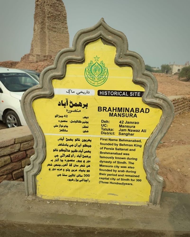
Signboard at the ancient city of Al-Mansura in Sindh (Photograph taken by Prof. Dr. Intesab Hussain Sadhayo)
 Remains of Mansura City
Governmental Structure; Sanghar District
At the Federal level, Sanghar district is allocated a set number of representatives in both the National Assembly and the Provincial Assembly:
- Number of seats in the National Assembly 3
- Number of seats in the Provincial Assembly 6
The district has 4 Municipal Committees:
- Sanghar
- Shahdadpur
- Sinjhoro
- Tando Adam
It has 11 Town Committees:
- Jam Nawaz Ali
- Berani
- Jhol
- Khadro
- Jatia
- Shahpur Chakar
- Sarhari
- Kandiari
- Tando Mitha Khan
- Perumal
- Khipro
Administrative Units; Sanghar District
The district is divided into 06 talukas as follows:
| Jam Nawaz Ali Taluka | 04 Union Councils |
| Khipro Taluka | 13 Union Councils |
| Sanghar Taluka | 11 Union Councils |
| Shahdadpur Taluka | 13 Union Councils |
| Sinjhoro Taluka | 12 Union Councils |
| Tando Adam Taluka | 10 Union Councils |
Table 1.2 Sanghar Administrative Divisions
Heritage Buildings/Archeological Spots/Picnic Areas; Sanghar District
- Chotiari Wetland Complex; Sanghar District, a reservoir of international importance spread over an area of about 18,000 HA, is located in a natural depression that exists along the left bank of the Nara Canal. The depression area is bounded by sand hills towards North, East, and Southeast, while in the West, and South lies the Nara Canal. Historically, the Chotiari Wetland Complex was flanked by the Makhi forest, which was famous for rich reserves of quality honey. Most of this forest was cleared and converted into agriculture fields during the British era, after the Hur Revolt
- The Talpur graveyard (containing the tomb of Mir Shahdad Talpur—described separately), one of the historical heritage sites of Sindh, is at Shahpur Chakar, Sanghar district. This is a graveyard for the family members of Mir Shahdad Talpur. Shahpur Chakar is named after Chakar Talpur, one of the Talpur amirs
- Qubbo Mir Shahdad, Shahpur Chaker, Sanghar, is the tomb of Mir Shahdad Talpur, who is regarded as one of the finest military commanders of Sindh. The tomb is located in Shahpur Chakar, a city of Sanghar District. Mir Shahdad Khan Talpur and Mir Chakar Khan Talpur are well known 12th century generals of the Kalhora Dynasty in Sindh. Mir Shahdad Khan was instrumental in helping the Kalhoras become rulers of Sindh. He established the town of Shahdadpur and made it a prosperous center of agriculture, trade, and learning. His son, Mir Chakar, is also buried at Qubbo Mir Shahdad. Mir Chakar Khan was the father of Mir Sohrab Khan who established the Talpur rule in Khairpur
- Brahmanbad and Mansura, locally known as Dalo Raja ji Nagri, in Tehsil Sinjhoro; Sanghar District, is an important archeological site, containing foundations of a large number of mosques, as well as coins discovered in the area, said to be those of the eastern Khalifas. Major H. T. Raverty, in his book Mehran of Sindh and its Tributaries, points out that this city was founded around 480 BC by the Brahman son of Afsandyar and was, thus, known as Brahmanabad. During Arab rule, another city was founded near its ruins and was called Mansura
- Mound Thulh, or Ruins of Kot Bijur, located in Deh Kot Biju, Taluka Sinjhoro; sanghar District, are the ruins of the Talpur fort. These are spread over 40 to 50 acres and contain a graveyard and a mud fort
- The tombs of Sohni and Mahiwal; Sanghar district are also a great tourist attraction. Sohni’s shrine is near Shahdadpur City and Mahiwal’s shrine is in the City Center, Shahdadpur

Figure 1.5 Chotiari Wetland Complex, Sanghar

Figure 1.6 Tomb of Sohni, Shahdadpur, Sanghar

Figure 1.7 A view of Brahmanabad
[1] The Chach Nama, or Tareekh-e-Hind wa Sindh (The History of India and Sindh), originally written in Persian, is the main source for Sindh’s ancient history.
[2] A Gazetteer of Sindh Province compiled by A W Hughes
[3] Sintubin, Manuel, and Iain Stewart. Ancient Earthquakes. Geological Society of Amer, 2010.
[4] Population Welfare Department, Government of Sindh, (http://www.pwdsindh.gov.pk/districts/Sanghar.htm)
Topography; Sanghar District
Topographically, Sanghar is divided into 2 broad parts: a green belt in the West and a desert in the East. The main Nara Canal is the dividing line between these 2 sections. The desert is comprised of sand dunes in the eastern part of Sanghar and Khipro Talukas and stretches over one-third of the area of the entire district. The desert area of Khipro Taluka is known as Achhro Thar (white desert), and it is actually a part of the great Thar Desert, which spreads along the eastern borders of Sindh (shared with India) and the Punjab provinces. The desert earned this name because of its characteristic whitish sand found in most parts of this area. Achhro Thar, then, is distinct from other parts of the great Thar Desert because of the rapid shifting of its sand dunes compared to other parts of the desert in Tharparkar district, which have relatively more stable dunes. Average elevation of the area is about 50 m above sea level.
The western part, or plain, has been formed by rich alluvial deposits of the River Indus and is, therefore, a valley of plains trenched with river channels in some places and overlain by raised beds in others. There are no mountains or hills in the district.
Rivers, Streams, and Lakes; Sanghar District
There are no natural rivers or streams in the district, but there are a number of lakes formed due to water seepage from the irrigation canals. Some of the important lakes of the district are: Baqar Lake, Makhi Lake, Khipro Lake, Sadhori Lake, Sanghriaro Lake, Dhalor Mori Lake, Sonhari Lake (Sonhari Lake has now been merged into Kinjhar Lake), Gujri Dhand, and the Chotiari Wetland Complex, which is an important wetland complex of Pakistan.
Forests; Sanghar District
Total area under forests in Sanghar district is 9,229 HA. Important forests of the district are:
- Khipro Forest. This is an irrigated plantation spread over an area of 9,600 acres (3,885 HA)
- Pir Pagara Reserve (privately owned)
- Tando Mitha Khan Game Reserve (5,343 HA)
- Awadhki Forest, along Nara Canal in Sanghar district
- Part of the Nara Desert Wildlife Sanctuary
The Chotiari Reservoir also supports scrub forests. This Reservoir can be demarcated into 4 distinct habitats, each with its specific flora and fauna:
- Desert scrub
- Sand dunes
- Riverine forest
- Reservoir area and its associated small natural lakes (Dhands)
The Riverine forest is dominated by populus or desert poplar (Populus euphratica), shisham or talhee (Dalbergia sissoo), khejri or loong tree/mesquite (Prosopis cineraria), kikar/babul (Acacia nilotica) and ber (Zizyphus mauritiana).
The vegetation in sand dunes and desert scrub includes milk weed (Calotropis procera), kair or karir (Capparis deciduas), vann or peelu (Salvadora oleoides), khimp (Crotolaria burhia), camel thorn (Alhagi maurorum) and phog (Calligonum polygonoides).
Aquatic vegetation of the reservoir comprises of bulrush (Typha latifolia), southern cattail (T. angustata), common reed (Phragmites karka), swamp morning glory (Ipomoea aquatic), gul-i-neelofar (Nymphaea lotus), lotus (Nelumbo nucifera), knot weed (Polygonum spp.), golden bladderwort (Uticularia lotus) and wild sugarcane (Saccharum spontaneum).
Soils; Sanghar District
The soils of Achhro desert are rolling to hilly sandy soils of aeolian deserts with hard clay loams, while some parts are true desert. The rest of the district has loamy and clayey soils of older river plains.
Climate; Sanghar District
The climate of Sanghar is tropical to subtropical. Like other districts of Middle Sindh, Sanghar district has extreme cold and extreme hot climate; however, there is a slight variation between the climate of the northern and the southwestern parts of the district. The southwestern portion enjoys the advantage of the sea breeze, making the climate slightly more moderate.
The summer season in the district lasts from April to October. May, June, and July are the hottest months. The mean maximum and minimum temperatures during June (the hottest month) are 42 °C and 25 °C respectively. August and September are monsoon months and are, thus, hot and humid. December, January, and February are the colder months, with January being the coldest. The mean maximum and minimum temperatures for January are 25 °C and 8 °C respectively.
Rainfall is sparse and erratic, and is most frequent between July and August when it averages 40 mm monthly. Annual average rainfall is about 125 mm. Floods are common during the monsoon season.
Seismic Activity/Seismicity; Sanghar District
The district belongs to Seismic Zone 2A of Pakistan’s Seismic Zone Map, which means there will be low to moderate damage to structures due to an earthquake
Population; Sanghar District
The following table shows the tehsil-wise population of Sanghar district as per the 2017 Census:
| Taluka/District | Area km2 | Population | Male% | Female% | Urban% | Growth Rate % |
| Sanghar District | 10,728 | 2,057,277 | 51.7 | 48.3 | 28.6 | 2.4 |
| Jam Nawaz Ali Taluka | 440 | 153,342 | ||||
| Khipro Taluka | 5,933 | 333,284 | ||||
| Sanghar Taluka | 2,118 | 434,087 | ||||
| Shahdadpur Taluka | 890 | 457,551 | ||||
| Sinjhoro Taluka | 907 | 320,874 | ||||
| Tando Adam Taluka | 440 | 357,919 |
Table 1.3 Sanghar Population Statistics
Religions; Sanghar district[1]
| Islam | 79.2% |
| Hindus | 19.3% |
| Christianity | 0.5% |
| Ahmadis | 0.1% |
| Scheduled Castes | 0.9 |
| Others | 0.1% |
Table 1.4 Sanghar Religions
Languages; Sanghar district[2]
| Urdu | 10.1% |
| Punjabi | 7.8% |
| Sindhi | 77.1% |
| Pushto | 1% |
| Balochi | 1.7% |
| Seraiki | 0.5% |
| Others | 1.9% |
Table 1.5 Sanghar Languages
[1] 1998 Census; 2017 Census Data has not been made public yet.
[2] 1998 Census; 2017 Census Data has not been made public yet.
Economic Activity – Economic Infrastructure
Economic Activity; Sanghar District
The major economic activity of the district is:
- Agriculture with its allied Livestock Breeding & Fishing (56.5%)
- Elementary Occupations (25.7%)
- Service Workers & Market/Shop Sales Workers (7.8%)
- Other (10%)
Land Use; Sanghar District
Land use statistics of Sanghar district as per Sindh Development Statistics 2017-18 are as follows:
| Land Use | Area | Land Use | Area |
| Total Area | 1,018,000 HA | Reported Area | 1,018,000 HA |
| Total Cultivated Area | 404,000 HA | Net Sown | 220,000 HA |
| Current Fallows | 184,000 HA | Total Uncultivated Area | 614,000 HA |
| Culturable Waste | 196,000 HA | Forest Area | 9,000 HA |
Table 1.6 Sanghar Land Use Statistics
Irrigation Network; Sanghar District
The desert area depends on rains for agriculture, while the remaining area is irrigated by the Sukkur Barrage/ Nara Canal. In fact, Nara Canal is a massive source of water in Sanghar district. The tributaries of Nara Canal include: Khipro Canal, Jamrao Canal, and Mithrao Canal.
The following table shows the mode of irrigation and area irrigated by the mode as per Sindh Development Statistics 2017-18:
| Total Irrigated Area | 126,315 HA | Un-irrigated Area | 93,426 HA |
| Canal Irrigated | 123467 HA | Wells Irrigated | – HA |
| Tube Well Irrigated Area | 2,848 HA |
Table 1.10 Sanghar Irrigation Statistics
Agriculture; Sanghar District
The district belongs to the Southern Irrigated Plains and Sandy Desert Agro-Ecological Zones of Pakistan. Agriculture in the Sandy Desert part depends upon rains, while the plains area depends completely on irrigation for agricultural activity. Agriculture and its allied livestock breeding is the mainstay of the rural areas of the district. Wheat, cotton[1], rice, sugarcane, rapeseed and mustard, jowar, bajra, maize, sesanum, arhar, sunflower, guar seed, maash, moong, soyabean, linseed, and sunflower are some of the crops of the district.
Major vegetables of Sanghar district include onions, potatoes, tomatoes, okra, tinda, brinjal, bitter gourd, bottle gourd, pumpkin, luffa, cucumber, long melon, beans, field vetch, turnips, carrots, spinach, cauliflower, cabbage, sweet potatoes, peas, radishes, garden peas, fenugreek, coriander, turmeric, garlic, ginger, and chilies.
Fruits grown in Sanghar district are banana, mango, guava, watermelon, muskmelon, papaya, phalsa, citrus, ber, mulberry, and chikoo.
Livestock Breeding; Sanghar District
The following table shows the livestock statistics as per the 2006 Livestock Census (Latest) for Sanghar district as stated in Sindh Development Statistics 2017-18:
| Cattle | 370,000 Heads | Buffaloes | 324,000 Heads | Sheep | 84,000 Heads |
| Goats | 697,000 Heads | Camels | 7,000 Heads | Asses | 46,000 Heads |
| Horses | 1,000 Heads | Mules | 1,000 Heads |
Table 1.7 Sanghar Livestock Statistics
The kankrej breed of cows, kachhi sheep, kamori goats, thoroughbred horses, and mehra camels are local breeds of Sanghar district.
Poultry Farms; Sanghar District
There are 841 poultry farms[2] in Sanghar district.
Fishing; Sanghar District
Fishing is carried out in Chotiari Reservoir Wetland Complex and other lakes/dhands of the district. Most of this fish is consumed locally. The lakes of Chotiari Wetland Complex are a source of subsistence and commercial fisheries for the local people and are a natural habitat for crocodiles, otters, and fresh water turtles, and are feeding and nesting grounds for a variety of resident and migratory birds.
Minerals and Mining; Sanghar District
Oil and gas is being mined in the district at a number of places, including Bobi/ Dhamrakhi, Chak 5 DIM South, Sanghar South Block, and Sinjhoro Block. No other metallic or non-metallic minerals are being mined in Sanghar district.
Industry and Manufacturing; Sanghar District
There are 2 Industrial Estates in Sanghar district: one is at Tando Adam and the other is in Sanghar. Both of these house a number of industries, most of which are agro-based and include: cattle and poultry feed, light engineering workshop, milk plant, oil expelling units, flour mills, rice husking, steel door and window manufacturing, food industry, and agricultural accessories.
According to the Official Website of National Vocational & Technical Training Commission of Pakistan, there are 55 industrial units in the District as follows:
| Flour Mills | 04 Units |
| Sugar Mills | 01 Units |
| Cotton Factory | 48 Units |
| Safety Matches | 02 Units |
Table 1.8 Sanghar Industries
Handicrafts; Sanghar District
Most of the areas in Sindh’s interior, including Sanghar, are prolific in the production of traditional handicrafts and artwork in different mediums like cloth, wood, clay, and glass. The only sources of income, in fact, for the Achhro Thar area of Sanghar district are fishing, livestock, and handicrafts. The handicrafts indigenous to the region include woven nets for different purposes (like fishing), rallies, mats, hand-woven carpets, rilli, and handheld fans made from date palm fronds, as well as embroidery on cloth.
Economic Infrastructure; Sanghar District
An important means of transport and communication in Sanghar district are roads and railways. There is a network of black topped roads in the district connecting all Taluka Headquarters and Towns to each other.
Road Statistics; Sanghar District
According to Road List 2009 (latest available) issued by the Government of Sindh, the road statistics of the district are:
| Provincial Highways | 187.6 km |
| Access Roads | 909.9 km |
| Secondary Roads | 1,097.4 km |
Table 1.9 Sanghar Road Statistics
According to Sindh Development Statistics 2017-18 the total road length in the district is 1,324 km.
Some of the important roads of the district are:
- National Highway N-5 passes through Sanghar (Saeedabad)
- Sanghar‒Hyderabad via Tando Adam Road
- Sanghar‒Nawabshah (Benazirabad) Road
- Sanghar‒Mirpur Khas via Sindhri Road
- Sanghar‒Shahdadpur via Jhol Road
- Sanghar‒Shahdadpur via Sinjhoro Road
- Tando Adam‒Kandiaro via Berani Road
- Tando Adam‒Tando Allahyar Road
- Shahdadpur‒Tando Adam Road
Rail and Airways; Sanghar District
The district connects via railway with other parts of Pakistan. There are railway stations at Nawaz Dheri, Sarhari Lundo, Shahdadpur, Jalal Mari, and Tando Adam. Another smaller railway line runs through the district from Nawabshah (now S. Benazirabad) via Shahpur Chakar to Khadro, Sinjhoro, Jhol, Bobi, Nauabad, and Patohayun.
There is no airport in the district; Nawabshah Airport (now S. Benazirabad) is the nearest airport.
Radio and Television; Sanghar District
There is one radio station in the district, planned and operated by Mehran Media (Pvt) Ltd. called Hot FM. There is no TV station in Sanghar district, but transmission of PTV can be seen through boosters, and rest of the television channels can be viewed through cable.
Telecommunications; Sanghar District
There are telephone exchanges in every city and town of the district. In addition, all the cellphone operators provide their services to every part of the district.
Post Offices/ Courier Services; Sanghar District
Pakistan Post Office has its offices in all Taluka headquarters with Urgent Mail Service (UMS) also easily available. TCS, the leading courier service provider in Pakistan, has a number of offices in various locations in the district. In all, there are 22 post offices[1] in the district.
Banking/ Financial Services; Sanghar District
Some of Pakistan’s major banks with branches in the district include:
- Al Baraka Bank Ltd.
- Allied Bank Ltd.
- Al Falah Bank Ltd.
- Al Habib Bank Ltd.
- Askari Bank Ltd.
- Bank Islami
- Burj Bank Ltd.
- Habib Bank Ltd.
- KASB Bank Ltd.
- Muslim Commercial Bank Ltd.
- National Bank of Pakistan Ltd.
- National Investment Bank Ltd.
- Sindh Bank Ltd.
- Soneri Bank Ltd.
- United Bank Ltd.
- Zarai Taraqiati Bank Ltd.
In all there are 74 branches of conventional banks and 14 branches of Islamic banks in the District[2].
In addition to these, the Sindh Rural Support program and various NGOs provide micro-credit facilities in the region.
Electricity and Gas; Sanghar District
HESCO (Hyderabad Electric Supply Corporation) is responsible for providing electricity to Sanghar district. There are 3 grid stations, 2 of 66 KV capacity and one of 32 KV, providing electricity to the district.
Educational Institutions; Sanghar District
The literacy rate of the district is 47% with 63% males and 30% females being literate. The following table shows the number of educational institutions in the district as per Sindh Development Statistics 2017-18:
| Institution | Boys/Girls | Institution | Boys/girls |
| Primary Schools | 2,542/224 | Middle schools | 75/32 |
| High School | 64/18 | Higher Secondary | -/- |
| Degree College | 03/03 | Technical Training | 04/- |
| Commercial Training | 03/- | Cadet Colleges | 01 |
| Vocational Training | 01/05 | Medical Colleges | – |
| Engineering Colleges | – | Universities | – |
Table 1.11 Sanghar Education Institutes
Healthcare Facilities; Sanghar District
The following table shows the number of health institutions in the district[1]:
| Institution | No./Beds | Institution | No./Beds |
| Government Hospitals | 05/380 | Government Dispensaries | 93/22 |
| Rural Health Centers | 06/70 | Basic Health Units | 60/120 |
| T B Clinics | 12/30 | Mother Child Health Centers | 05/- |
| Private Hospitals | 40/186 | Private TB Clinics | 01/- |
| Private Dispensaries | 40/186 | Private MCHC | 01/- |
Table 1.12 Sanghar Health Institutes
Policing; Sanghar District
Hyderabad Regional Office is responsible for looking after the policing infrastructure in Sanghar district. The Additional Inspector General Police (AIGP) is in charge of the Hyderabad Zone. The District Police Officer (DPO) Sanghar is over all in charge of the district, and reports directly to the AIGP Hyderabad.
There are a total of 18 police stations[2] in Sanghar district. Each Police station is headed by Deputy Police Officer/ Senior Superintendent Police.

Figure 1.8 A Shrine (Dargah Haji Shareef) in Sanghar
Figure 1.9 Chotiari Dam; Sanghar
[1] Health Profile Sindh District 2017
[2] Official Website Sindh Police
[1] Official Website Pakistan Post
[2] List of Reporting Bank Branches 2019, by State Bank of Pakistan.
[1] Sanghar is the top cotton producing district of Sindh
[2] Table 17 Number of Commercial Poultry Farms and Number of Birds by Size of Flock
Environment and Biodiversity; Sanghar District
District Sanghar belongs to the environmentally rich Indus Eco Region. The World Wildlife Fund (WWF) and IUCN Pakistan are both working to conserve the environment and biodiversity of the Chotiari Reservoir, which is a wetland complex of international importance. Since the district is devoid of any major industry, the only sources of air pollution are dust particles and vehicular emissions.
Flora and Fauna; Sanghar district
Flora; Sanghar district
The most common trees found in the irrigated zones of the district are talhee or shisham (Dalbergia sissoo), babul or gum Arabic (Acacia nilotica), mulberry (Morus alba), neem (Melia azadirech), kono or Ethiopian teak (Conocarpus lancifolius), simal or silk cotton tree (Salmalia malabaricum), sufaida (Eucalyptus camaldulensis), gul mohar (Poinciana pulcherima), sirin or Indian walnut (Albizzia procera), tamarind or imli (Tamarindus Indica), jungle jalebee or monkey pod (Pithecolobium dulce), chimkani or amaltas (Cassia fistula), bur or Bengal fig (Ficus bengalensis), Egyptian sesbania or jantar (Sesbania aegyptiaca), arjuna or white marudah (Terminalia arjuna), and Indian tulip tree or paras pipul (Thespesia populnea).
The Achhro Thar area of the district supports milkweed (Calotropis procera), kair or karir (Capparis deciduas), vann or peelu (Salvadora oleoides), khimp (Crotolaria burhia), camel thorn (Alhagi maurorum) and phog (Calligonum polygonoides).
Aquatic vegetation of the district comprises of bulrush (Typha latifolia), southern cattail (T. angustata), common reed (Phragmites karka), swamp morning glory (Ipomoea aquatic), gul-i-neelofar (Nymphaea lotus), lotus (Nelumbo nucifera), knotweed (Polygonum spp.), golden bladderwort (Uticularia lotus) and wild sugarcane (Saccharum Spontaneum).
Fauna; Sanghar district
The forests/ irrigated plantations and the Chotiari Wetland Complex support and provide sanctuary to a large number of fauna. Some of the important mammals include hog deer, chinkara, desert cat, fishing cat, caracal or jungle lynx, smooth-coated otter, wild boar, desert hare, Bengal fox, Asiatic jackal, and feral wild ass. Within the Chotiari Wetland Complex, there are 19 varieties of small mammals. Besides the above mentioned mammals, there are palm squirrels, mongoose, grey mongoose, bats, rats, hedgehogs, porcupine, Balochistan gerbil, house shrew, and Indian gerbil.
Avifauna of the district as well as the Chotiari Wetland Complex include marbled teal, Sindh babbler, pallas’s fish eagle, white-backed vulture, saker falcon, partridge, watercock, wood sandpiper, knot, ruff, painted snipe, cliff swallow, grebe, cormorant, bittern, egret, black shouldered kite, buzzard, black and grey partridges, water hen, moor hen (scarce), pheasant-tailed jacana (rare), chestnut-bellied sandgrouse (scarce), pigeon, dove, parakeet, cuckoo, pied-crested cuckoo (scarce), barn owl (rare), kingfisher, bee-eater, Sindh jungle sparrow (rare), black-crowned night heron (scarce), paddy field pipit (scarce), herons, greater white-fronted goose (rare), and mallard (less common)[1].
Reptiles and amphibians of the Wetland Complex include Indian marbled toad, Indian skipper frog, golden frog, brown roofed turtle, Indian roofed turtle (on IUCN Red List), Indian soft shell turtle (rare), marsh crocodile (rare), garden lizards (scarce), ground agama (rare), Afghan ground agama (rare), leopard gecko, a variety of lizards and geckos, three-toed snake, saw-scaled vipers, cobras, painted keelback (rare), and Russell’s viper[2].
Protected Wildlife Areas and Endangered Wildlife; Sanghar District
There are 4 protected wildlife areas in Sanghar district:
- Chotiari Wetland complex; Sanghar district. It provides sanctuary to a wide variety of flora and fauna
- Khipro Game Reserve; Sanghar district
- Tando Mitha Khan Game Reserve; Sanghar district
- Part of Nara Desert Game Reserve; Sanghar district
These protected areas provide sanctuary to all of the mammals and game birds found in these habitats. The endangered fauna include hog deer, fishing cat, marsh crocodile, smooth-coated otter, python, marbled teal, Sindh warbler, pheasant-tailed jacana, greater white-fronted goose, barn owl, mallard, black-crowned night heron, moor hen, pied-crested cuckoo, sand grouse, and the Sindh jungle sparrow.

Figure 1.4 Critically Endangered Mugger Crocodiles (Nara Canal)
[1] For complete list of all fauna of Chotiari Wetland Complex please visit http://www.foreverindus.org/pdf/sites/chotiari_2.pdf
[2] For complete list of all fauna of Chotiari Wetland Complex please visit http://www.foreverindus.org/pdf/sites/chotiari_2.pdf