Share now
Map of Balochistan

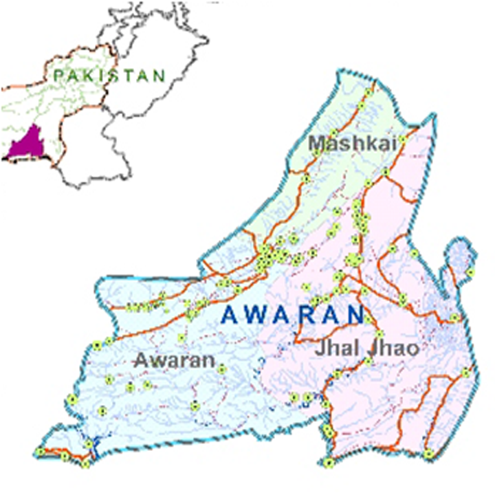
Map of Awaran District
Balochistan Districts
- Quetta District Profile
- Awaran district Profile
- Barkhan District Profile
- Bolan District Profile
- Chagai District Profile
- Dera Bugti District Profile
- Gwadar District Profile
- Harnai District Profile
- Jaffarabad District Profile
- Jhal Magsi District Profile
- Kalat District Profile
- Kech District Profile
- Kharan District Profile
- Khuzdar District Profile
- Killa Abdullah District Profile
- Killa Saifullah District Profile
- Kohlu District Profile
- Lasbela District Profile
- Loralai District Profile
- Mastung District Profile
- Musakhel District Profile
- Nasirabad District Profile
- Nushki District Profile
- Panjgur District Profile
- Pishin District Profile
- Sherani District Profile
- Sibi District Profile
- Washuk District Profile
- Zhob District Profile
- Ziarat District Profile
Also visit: Sindh, Punjab, Khyber Pakhtunkhwa
Awaran District Profile
Introduction Geographical; Details Awaran District
Awaran district is located from 25° 25Ꞌ 50” to 27° 25Ꞌ 3” north latitudes and from 64° 07Ꞌ 27” to 66° 15Ꞌ 36” east longitudes. It is bounded in the northwest by Kharan and Panjgur districts, in the northeast by Khuzdar district, in the east by Lasbela district, in the south by Lasbela and Gwadar districts, and in the west by Kech district.
Awaran District at a Glance
| Name of District | Awaran District | |
| District Headquarters | Awaran Town | |
| Population[1] | 122,011 persons | |
| Area[2] | 29,510 km2 | |
| Population Density[3] | 4.89 persons/ km2 | |
| Population Growth Rate[4] | 0.17% | |
| Male Population[5] | 51.8% | |
| Female Population[6] | 48.2% | |
| Urban Population[7] | 28.1 | |
| Administrative Units |
03 Tehsils:
|
|
| Main Towns/ Villages | Awaran, Jhal Jhao, Mashkai, Jebree Village, Lak Pass, Manjwani Pass, Bansar, and Gajjar | |
| Literacy Rate[8] | 46% | |
| Male Literacy Rate[9] | 63% | |
| Female Literacy Rate[10] | 23% | |
| Major Economic Activity[11] | Agriculture with its allied livestock breeding | 56.8% |
| Construction | 18.9% | |
| Community, Social And Personal Services | 7.8% | |
| Manufacturing | 6.2% | |
| Electricity, Gas & Water | 6.1% | |
| Others | 4.2% | |
| Main Crops | Wheat, barley, jowar, maize, rice, maash, moong, cotton, canola, and fodder | |
| Major Fruits | Apples, apricots, peaches, plums, grapes, pomegranates, almonds, dates, watermelon, and musk melon | |
| Major Vegetables | Onions, potatoes, chilies, tomatoes, coriander, peas, okra, tinda, radish, spinach, cabbage, carrots, bitter gourd, bottle gourd, brinjal, luffa, and cucumber | |
| Forest Area[12] | 89,600 HA[13] | |
| Black Topped Roads[14] | 527.0 km | |
| Shingle Roads[15] | 1,282.0 km | |
| Grid Stations[16] | Electricity is supplied by Quetta Electric Supply Company (QESCO). No other data is available | |
| No. of Tel. Exchanges[17] | 01 Telephone Exchange providing 516 landline connections, 1,010 wireless phone connections and 429 broadband connections. | |
| No. of Industrial Units[18] | None | |
| Major Industry[19] | None | |
| Household Size[20] | 5.4 persons per house | |
| Houses with Piped Water[21] | 7% | |
| Houses with Electricity[22] | 0.4% | |
Table 1.1 Awaran District at a Glance
[1] 2017 Census
[2] 1998 Census
[3] 2017 Census
[4] 2017 Census
[5] 2017 Census
[6] 2017 Census
[7] 2017 Census
[8] Pakistan Social & Living Measurement Survey 2014-15 (PSLM); Latest available
[9] PSLM
[10] PSLM
[11] 1998 Census; 2017 Census Data has not been made public yet.
[12] Balochistan Development Statistics, 2018-19
[13] Land Utilization Statistics report 94,711 HA under forests.
[14] Balochistan Development Statistics, 2018-19
[15] Balochistan Development Statistics, 2018-19
[16] Balochistan Development Statistics, 2018-19
[17] Balochistan Development Statistics, 2018-19
[18] GoB and UNICEF. Awaran District Profile 2011
[19] GoB and UNICEF. Awaran District Profile 2011
[20] 1998 Census; 2017 Census data has not been made public yet.
[21] 1998 Census; 2017 Census data has not been made public yet.
[22] 1998 Census; 2017 Census data has not been made public yet.
Brief History – Governmental Structure – Administrative Units – Heritage Buildings and Tourist Attractions
Brief History of Awaran District
Awaran district was given the status of a separate district in 1992; till then, it was a tehsil of Khuzdar district.
During British Rule, Khuzdar was the headquarters of the Jhalawan Division of Kalat State. At Partition,[1] Jhalawan was the southernmost district/subdivision of the Balochistan State Union which consisted of the Kalat, Kharan, Makran, and Lasbela Princely States. In 1955, when One Unit[2] was formed, all Princely States were abolished, and Jhalawan/Kalat was merged with West Pakistan.
The early history of this part of Balochistan is obscure, and very little definite information is available about the time period before the advent of the Arabs (who ousted the Rai Dynasty of Sindh) in the 7th century AD.
General Krateros of Alexander’s army has been mentioned in the Gazetteer of Sarawan, Kachhi, and Jhalawan 1907. According to this text, the general, with his men, crossed over to Persia (on his way back to Greece) via the Mula Pass.[3] Sir T. Holdich[4] conjectures that he went by the Mula Pass and crossed the settlement of Choarene, which could have been Khuzdar. After that, nothing has been recorded about the history of this area till the arrival of the Arabs.
During Arab rule, Khuzdar was the principle settlement of this area, located as it was at the convergence of roads from Multan (via Mula Pass), Makran, and Kandahar. This made it an important area for the Arab rulers. Awaran was located on the route of Arab trading caravans as well as Arab armies traveling to and from the Arabian Peninsula. To-date, it is located at the confluence of the link road between Turbat-Gawadar-Karachi and Karachi-Quetta Regional Cooperation Development (RCD) highway.
Awaran was previously known as Kolwa.[5] Kolwa Chil is the name of a stream coming down from the west of Awaran city.
locally the name “Awaran” is a combination of “Awar” and “An”. awar means a union of two or more streams The Kolwa Chil and Doraski stream and other tributaries combine here thus giving Awaran the district[6].
Governmental Structure Awaran District
At the Federal level, Awaran district is allocated a set number of representatives in both the National Assembly and the Provincial Assembly:
- Number of seats in the National Assembly[7] 1
- Number of seats in the Provincial Assembly 1
Under the Local Government Act 2010, Amended in 2011, Awaran district has one District Council and 2 Municipal Committees as follows:
- Awaran
- Gajjar Mashkey
The District Council has 10 Union Councils. Each Union Council is represented by one member in the District Council. In addition, there is special representation of women (33%) and of workers and peasants (5% each).
Administrative Units; Awaran District
Awaran district covers an area of 29,510 km² and is subdivided into 3 tehsils named after their major towns:
| Awaran Tehsil | 03 Union Councils |
| Jhal Jhao Tehsil | 02 Union Councils |
| Mashkai Tehsil | 03 Union Councils |
Table 1.2 Awaran Administrative Divisions
Historical/ Heritage Sites and Tourism/ Picnic Spots Awaran district
There are no historical/ heritage protected sites in the district.
The Hingol National Park is the largest National Park, parts of which are located in Awaran. It houses a large variety of fauna and flora, which makes it a good tourist spot as well as picnic area.
The Hinglaj Mata Mandir (Hindu temple) located in the Hingol National Park is dedicated to Hinglaj Mata, a powerful Hindu deity who is believed to bestow good on all her devotees. Hinglaj is her main temple, but there are other temples dedicated to her in the neighbouring Indian States of Gujarat and Rajasthan.
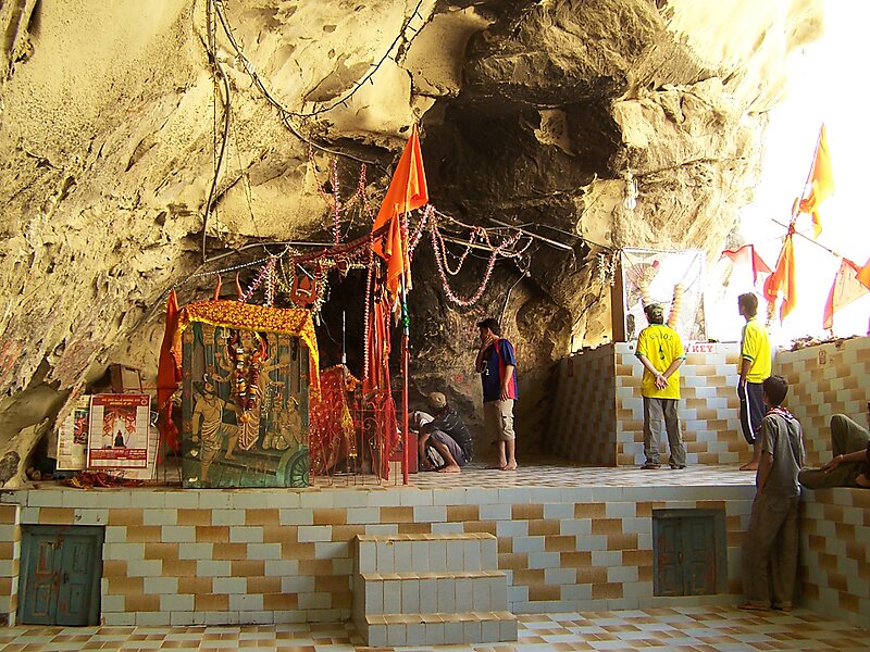
Figure 1.9 Hinglaj Mata Mandir in Hingol National Park
[1] India’s partition into India and Pakistan in 1947
[2] One Unit was a geo-political program under which the four provinces of West Pakistan were merged into a single province in 1955. The provincial system was reinstated in 1970
[3] Mula Pass is located in the Central Brahvi Range
[4] Sir Thomas Holdich was a geographer, and the president of the Royal Geographical Society
[5] Government of Balochistan Official Website; retrieved on September 2017.
[6] https://odysseuslahori.blogspot.com/2015/01/a-meeting-of-rivers.html
[7] Shared by Lasbela
Topography Awaran District
The topography of the district is dominated by rough mountains and hills, which run from northeast to southwest. The general elevation of the district varies from about 1,000 to 2,000 m above sea level. The eastern part of the Central Makran Range runs along the northwestern border of Awaran. Parallel to this range, further east, are the Garr hills. The two ranges are separated by the Mashkai River, which is a tributary of the Hingol River. The Hingol flows down the Central Makran Range.
The central part of the district is covered by the Kolwa and Jhao Hills, with an elevation of 600 to 1,000 m above sea level. The southern portion of the district is covered by the Makran Coastal Range which includes the Mahapal Band, Taloi Band, Rudia, Gurangatti, Kullit, Haro, and Hala Hills, with elevations ranging from 600 to 1,200 m above sea level. There are dry river valleys in between these hills.
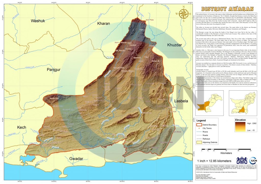
Figure 1.3 IUCN GIS Map District Awaran
Rivers, Streams, and Lakes of Awaran district
The important river of the district is Hingol, which has several tributaries which drain the district. Important tributaries are the Mashkai and Nal. The Nal River, in its upper portions, is called Gidar Dhor, and originates from the Surab Valley. Other seasonal rivers/streams of the district are Kud, Arra, Mur, Habibo, Parkin, Lop River, Churok Kaur, Sigar Kaur, Chil River, Kolwa Chhil Kaur, and Pao River.
Some of the seasonal streams are Doraski Dap Kaur, Zandugawash Kaur, and Chaki Kaur.
Forests Awaran District
There are no State Forests in Awaran. All uncultivated areas of the district have been designated as forests, and the Forest Department is planting saplings on this land while also distributing saplings to the general public for planting. Other Government Agencies are also helping the Department by planting saplings.
Part of the Hingol National Park lies in the Awaran district.
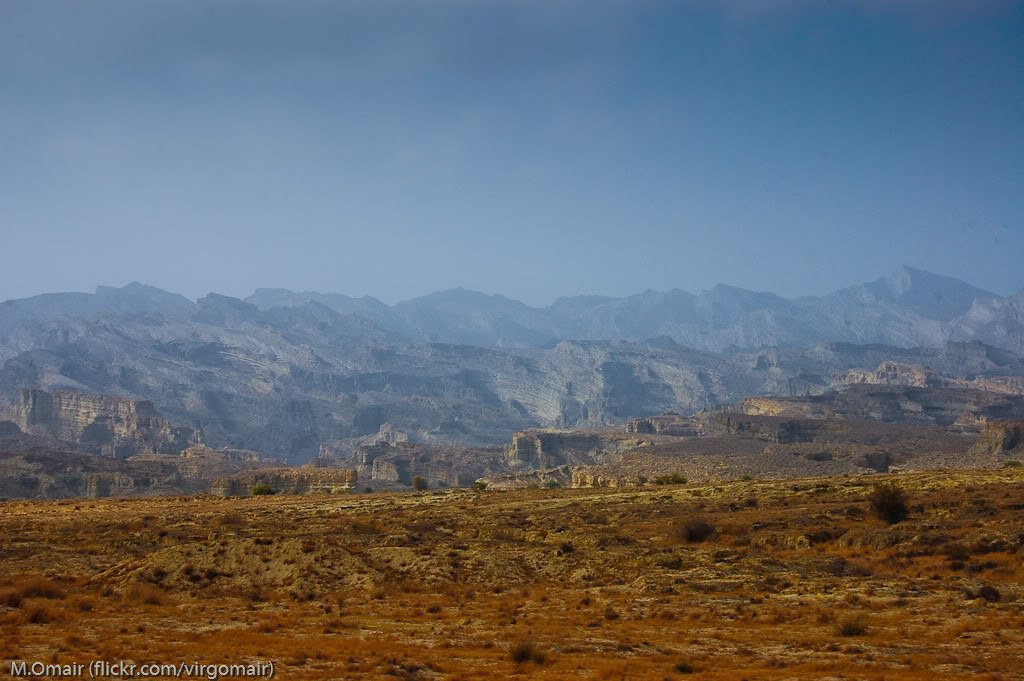
Figure 1.4 Awaran District Topography
Soils of Awaran district
The soil of the district is fertile both in irrigated and un-irrigated tracts, but due to the non-availability of water, most of the area is permanently barren. The soil of Mashkai, Jhal Jhao, and surrounding areas of Awaran is very fertile.
Climate of Awaran district
The climate of Awaran is hot in the summer and cool in the winter. Dust storms are frequent throughout the year. The storms become very severe from June to September, when they are locally known as livar. Summer days are hot but nights are cool. June is the hottest month, with maximum and minimum temperatures of about 39 °C and 24 °C respectively. January is the coldest month, with mean maximum and minimum temperatures of 17 °C and 4 °C respectively.
The rainfall in the area is scanty and uncertain. Normally, July is the wettest month. Usually there is more rainfall during winter than in summer; winter rains occur from December to March. Mean annual rainfall recorded at Khuzdar (the nearest Meteorological station) is 109 mm.
Seismic Activity Awaran district
The district belongs to Zone 2B of the Seismic Zone Map of Pakistan. This means there will be minor to moderate damage to property in case of an earthquake.
Population Awaran district
The following table shows the population of the district according to 2017 Census:
| Tehsil/ Taluka |
Area Km2 |
Population | Male% | Female% | Urban % | Growth Rate % |
| Awaran District | 29,510 | 122,011 | 51.8 | 48.2 | 28.1 | 0.17 |
| Awaran Tehsil | NA | 30,228 | ||||
| Mashkai Tehsil | NA | 32,897 | ||||
| Jhal Jhao Tehsil | NA | 40,033 |
Table 1.3 Awaran Population Statistics
Religion Awaran District[1]
| Muslims | 99% |
| Christians | Negligible % |
| Hindus | Negligible % |
| Ahmadis | Negligible % |
| Scheduled Castes | 0.2% |
| Others | 0.7% |
Table 1.4 Awaran Religions
Languages Awaran district[2]
| Urdu | 0.1% |
| Punjabi | Negligible % |
| Sindhi | Negligible % |
| Pushto | Negligible % |
| Balochi | 99.7% |
| Seraiki | Negligible % |
| Others | Negligible % |
Table 1.5 Awaran Languages
[1] 1998 Census; 2017 Census data has not been made public yet.
[2] 1998 Census; 2017 Census data has not been made public yet.
Economic Activity – Economic Infrastructure
Economic Activity Awaran District
The main economic occupations of the district[1] are:
- Agriculture with its allied livestock breeding (56.8%)
- Construction (18.9%)
- Community, Social And Personal Services (7.8%)
- Manufacturing (6.2%)
- Electricity, Gas, and Water (6.1%)
- Others (4.2%)
According to the United Nations’ Human Development Indicators, Awaran is the most underdeveloped district in Balochistan, Pakistan.
[1] 1998 Census; 2017 Census data has not been made public yet.
Land Use Awaran District
The following table shows the main land use statistics of the district as per Balochistan Development Statistics 2018-19:
| Total Area | 295,100 HA | Reported Area | 211,587 HA |
| Total Cultivated Area | 143,722 HA | Net Sown | 26,174 HA |
| Current Fallow | 117,548 HA | Total Uncultivated Area | 67,865 HA |
| Culturable Waste | – HA | Forest Area | 67,865 HA |
Table 1.6 Awaran Land Use Statistics
Irrigation Network; Awaran district
The district is mostly barani, and depends on rain water for harvesting. The ancient karez system is still in use in the district. The following table shows the mode of irrigation and area being irrigated by the mode (Balochistan Development Statistics 2018-19):
| Total Irrigated Area | 25,589 HA | Government Canals | – HA |
| Private Canals | – HA | Wells | 1,830 HA |
| Tube wells | 22,979 HA | Karez/Spring/Others | 780 HA |
Table 1.9 Awaran Irrigation Statistics
A number of small dams are being constructed which will help irrigate the lands; these are:
- Pelar Dam on Nal River
- Jodair Delay Action Dam (recently completed)
- Sang-e-Kalat Dam
Agriculture Awaran district
The district is included in the Dry Western Plateau Agro-Ecological Zone of Pakistan; farming activity is mostly barani or rain-fed, based on subsistence level farming. The land is mostly irrigated by springs, karezes, and tube wells.
The crops of the district are wheat, barley, jowar, maize, rice, maash, moong, cotton, canola, and fodder.
The fruits grown in the district are apples, apricots, peach, plums, grapes, pomegranates, almonds, dates, watermelon, and musk melon.
The vegetable produce of the district includes onions, potatoes, chilies, tomatoes, coriander, peas, okra, tinda, radish, spinach, cabbage, carrots, bitter gourd, bottle gourd, brinjal, luffa, and cucumber.
Livestock Breeding Awaran district
Livestock is a very important sector of the economy. It is the main source of income for nomadic families.
The following table shows the Livestock Population in the district, drawn from the Livestock Census 2006 (qtd. in Balochistan Development Statistics 2018-19):
| Cattle | 18,485 Heads | Buffaloes | 40 Heads | Sheep | 125,772 Heads |
| Goats | 344,318 Heads | Camels | 5,335 Heads | Horses | 59 Heads |
| Mules | 20 Heads | Asses | 6,491 Heads |
Table 1.7 Awaran Livestock Statistics
The indigenous livestock breeds of the region are brahvi camel, mangeli sheep, and lehri goat.
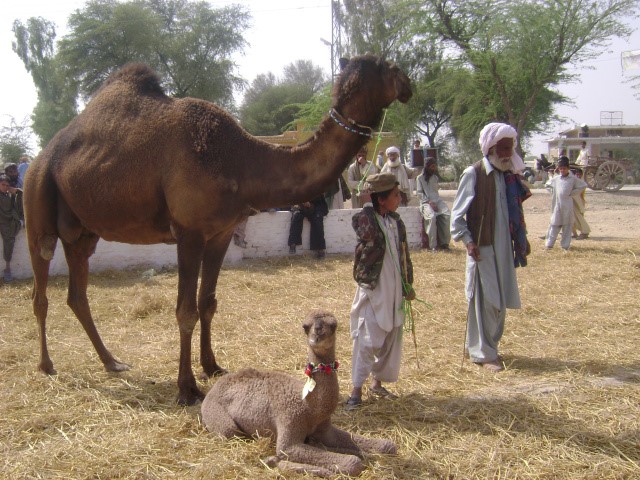
Figure 1.5 Brahvi Camel
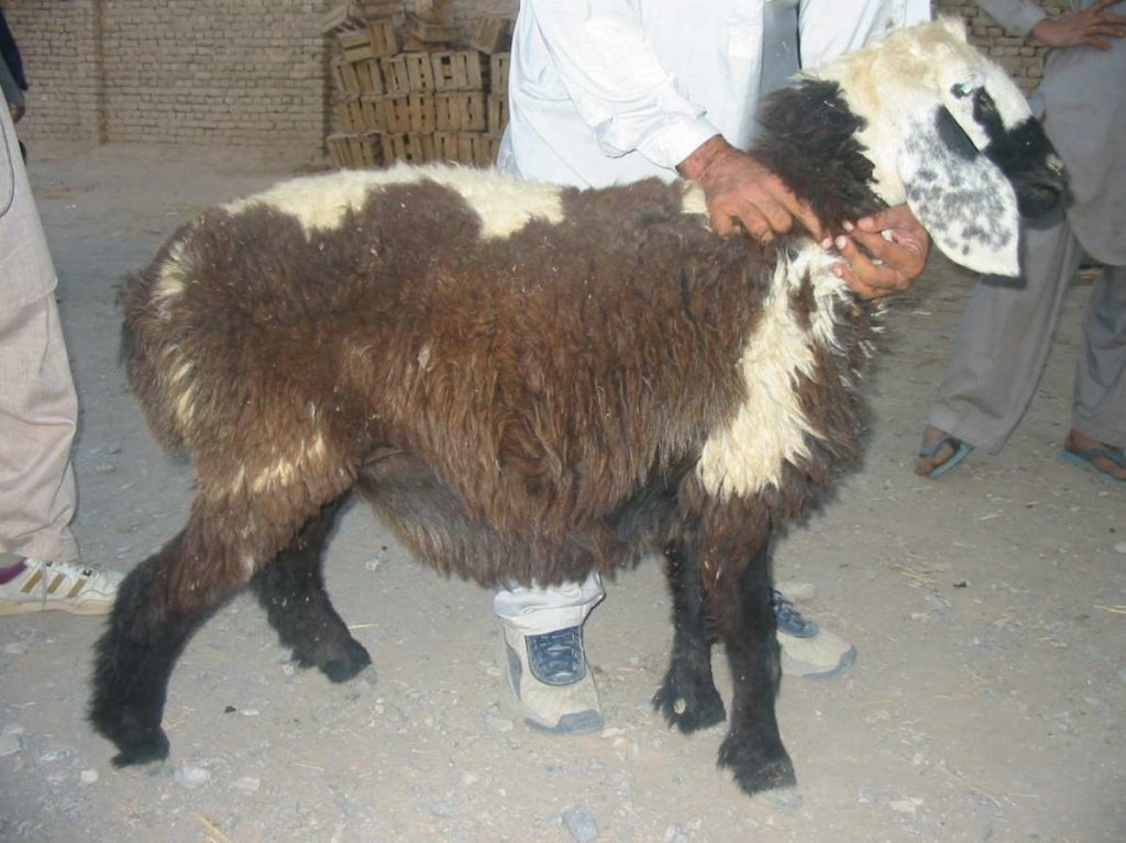
Figure 1.6 Mengali Sheep
Poultry Farms Awaran district
No data is available on the number of poultry farms in the district, but, according to the Livestock Census 2006 (qtd. in Balochistan Development Statistics 2018-19), there are 111,486 poultry birds in the district.
Fishing Awaran district
Fish is found in the Hingol River in limited quantities. Fishing does not contribute to the economic activity in the district.
Bee Keeping/ Apiculture
Only wild honey is locally used in the district, and bee keeping is not a statistically significant commercial/ economic activity.
Minerals and Mining Awaran district
Due to a lack of infrastructure, transport facilities, and communication problems, mineral resources are still unexplored in Awaran. The district possesses large quantities of chromate and building stone but these are yet to be mined, although asbestos, barite, and building stones are being mined on a small scale.
Industry and Manufacture; Awaran District
There are no industrial units in the district. The district lacks infrastructure and other basic services, which impedes industrial development and investment.
Trade (Import/Export); Awaran district
Trade activities are import-oriented and no significant export of goods is reported in the district. A small quantity of dates is exported to Karachi and Quetta, while almost all consumer items are imported from Karachi, Quetta, and Turbat.
Handicrafts; Awaran district
The only handicrafts of the district are embroidery on clothes, and sandals/shoe making, which is generally undertaken by the women of the district, who sell their work (completed in the domestic setting) to brokers at low prices. This work is subsequently sold in urban markets like Karachi and Quetta.
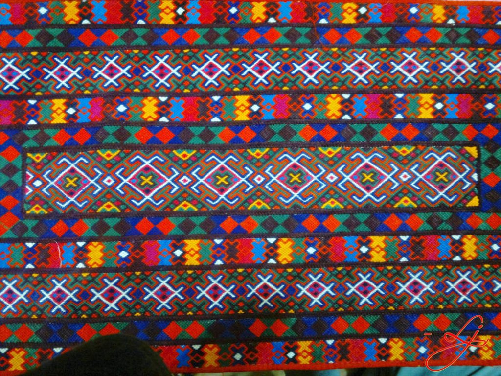
Figure 1.7 Balochi Embroidery
Economic Infrastructure Awaran District
Awaran has limited infrastructure and lacks roads, as well as other means of transportation, communication, and even electricity. However, over the past few years, the situation has improved, and some facilities have been developed in the district.
Road Statistics; Awaran district
According to Balochistan Development Statistics 2018-19, the road statistics of the district are as follows:
| Total Roads | 1,809 km |
| High Type Roads/ black topped | 527 km |
| Low Type Roads/ Shingle | 1,282 km |
Table 1.8 Awaran Road Statistics
Some of the important roads of the district include Karachi Road, which connects Motorway M-8 with National Highway N-25 at Bela.
Some important shingle roads are:
- Road connecting Awaran to Khuzdar
- Turbat to Karachi
Rail and Airways; Awaran district
No rail or air service is available in the district. The nearest airport is at Khuzdar, called the Khuzdar Airport.
Radio and Television; Awaran district
No television booster functions in the district; the nearest radio station is at Turbat.
Telecommunications; Awaran district
The district is connected to other parts of the country through telephone and telegraph. There is 01 telephone exchange in Awaran, which provide 516 landline connections, 1,010 wireless phones and 429 broadband connections in the district (Balochistan Development Statistics 2018-19).
Cellular phone companies also provide their services in the district.
Post Offices/ Courier Services; Awaran district
There is only one post office in the entire district (Balochistan Development Statistics 2018-19). Courier companies provide services in the district as well.
Banking/ Financial Institutions Awaran district
According to the List of Reporting Bank Branches 2019 by State Bank of Pakistan, the following banks have their branches in the district:
- National Bank of Pakistan
- United Bank Ltd.
- Zarai Taraqiati Bank Ltd.
In all there are 04 branches of various conventional banks in the District.
Electricity and Gas Awaran district
Quetta Electric Supply Company (QESCO) looks after the supply and transmission of electricity to the district. The district receives its electric supply through the Turbat Grid Station.
Educational institutions; Awaran district
The following table shows the number of primary, middle, secondary, and mosque schools (among others) in the district, as per Balochistan Development Statistics 2018-19:
| Institution | Boys/Girls | Institution | Boys/Girls |
| Primary Schools | 164/52 | Middle Schools | 18/09 |
| High Schools | 19/04 | Community Schools | 20 |
| Higher Secondary | 02/- | Degree Colleges | – |
| Universities | – | Mosque Schools[1] | – |
| Vocational Training Schools | – |
Table 1.10 Awaran Educational Institutions
In addition there are privately owned educational institutions in the District.
Healthcare Facilities; Awaran district
The following table shows the Government Health Care Institutions in Awaran district as per Balochistan Development Statistics 2018-19:
| Institution | No./beds | Institution | No./beds |
| Teaching Hospitals | – | Hospitals | 1/14 |
| Rural health Centers | 02/20 | Basic Health Units | 07 |
| Dispensaries | 15/- | Mother Child Health Centers | 01 |
| TB/Leprosy Clinics | 01 |
Table 1.11 Awaran Health Institutions
There are no private sector health facilities in the district.
Policing; Awaran district
Levies and the Makran Scouts are responsible for policing the district. There are 3 levies or thanas (posts) in the district. The levies force is directly under the control of the Deputy Commissioner through the Assistant Commissioner and the Tehsildars. The Makran Scouts provide assistance to the thanas. The levies consist of Rasaldars, Jamadars, Dafadars, Hawaldars, Sawars, and other supportive staff including assistants, clerks, and drivers.
Justice is delivered through regular, as well as Qazi courts. The regular courts decide cases according to the criminal and civil laws applicable throughout the country, while the Qazi court makes decisions according to the Shariah laws as well as the constitutional laws of the Kalat Princely State (Qanun Diwan-i-Kalat).
There are 02 Police stations in the District (19.7 (a) Number of Police Stations by Division/District by Federal Bureau of Statistics 2019).
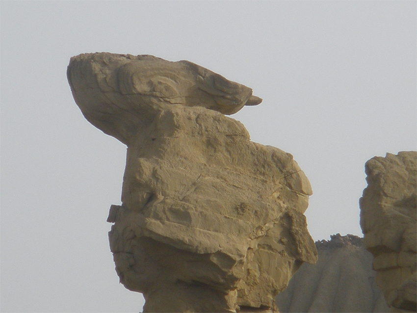
Figure 1.10 A Mountain outcrop in Jhao, Awaran
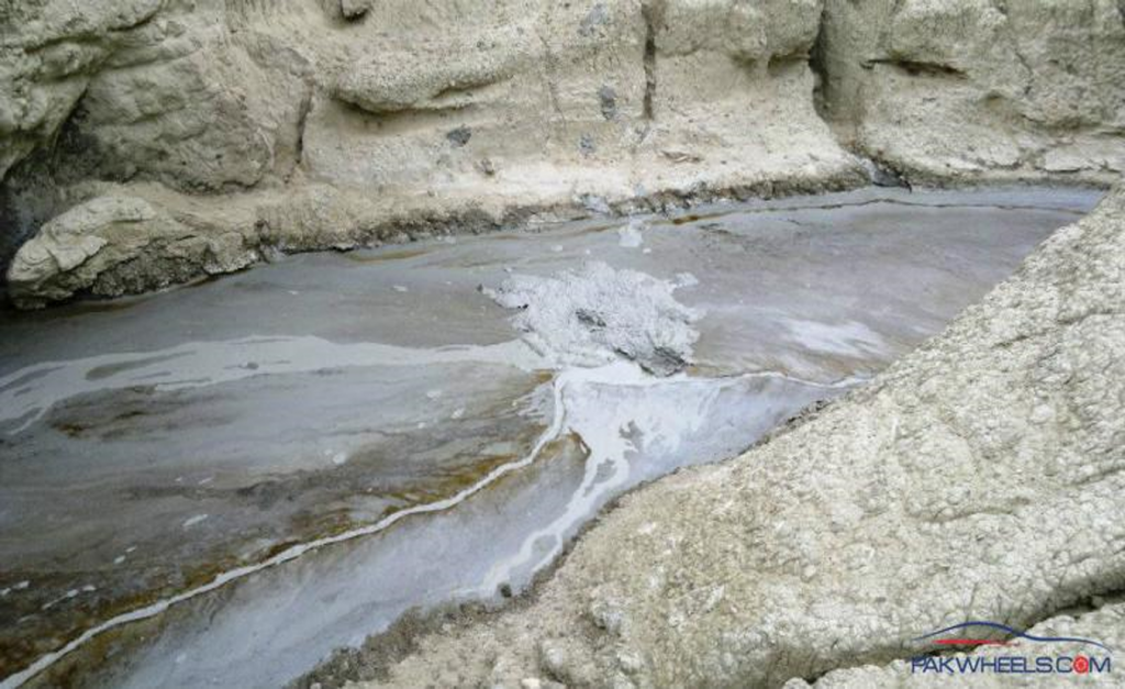
Figure 1.11 Lava issuing from a Mud Volcano, Hingol Park
[1] included in primary schools
Environment and Biodiversity Awaran district
The district is free from air pollution as there is very little heavy traffic on roads and no industry. Presence of dust and a lack of a sanitation system in place in the district causes pollution. Potable water is a scarcity.
Flora and Fauna Awaran District
There is very little vegetation in Awaran district. There are no forests and the trees are few and scanty; most common trees are date palm trees.
Flora Awaran district
The most common flora besides the date palm includes khagal (Tamarix), willow (Salix), chitta kanda (Otostegia auohesi) and a variety of the caper bush (Pyonotheco spinosa), a spiny bush (Convolvulus spinosus), jujube or ber (Zizyphus nummularia), kikar (Acacia jaquemontii), vann or jal/pilu (Salvadora oleoides), gugal or mukul myrrh (Commiphora mukal) and mazari palm (Nannorrhops ritchieana), khijri or long tree (Prosopis cineraria), and Arabic gum (Acacia nilotica).
Flora of Hingol National Park includes babul or kikar (Acacia nilotica), gum Arabic or khumbat (Acacia Senegal), aak (Calotropis precera), appi api putih (Avicennia alba), karir (Capparis decidua), khavi grass (Cymbopogon jwarancusa), valaiti babul (Parkinsonia aculeate), and sirin (Cassia italica).
Fauna Awaran district
Hingol National Park supports 35 species of mammals, 65 varieties of amphibians and reptiles, and 165 types of avifauna. Mammals include Sindh ibex, Afghan urial, chinkara gazelle, jackals, honey badger, hedgehog, leopard, pangolin, shrews, bats, flying fox, red lynx, jungle cat, sand cat, desert wolf, caracal, Asiatic jackal, wild boar, and black bear.
Amphibians of the park include marsh crocodile, green turtle, masher fish, olive ridley (sea turtle), desert monitor lizard, varieties of chameleons, and yellow monitor lizard.
Avifauna of the park include laggar falcon, red-headed merlin, kestrel, grey partridge, eagle owl, Sind-pied woodpecker, finch, lark, hoopoe, shrike, wheatear, 3 varieties of vultures (namely, Eurasian griffon vulture, Egyptian vulture and the cinereous vulture), and the sand grouse. The houbara bustard, Dalmatian and spot-billed pelican are regular visitors to the area.
Protected Areas and Wildlife Awaran district
Parts of the Hingol National Park and the Kolwakop Wildlife Sanctuary are the Protected Wildlife Areas of the district. These areas are located in the Hingol River Basin and provide sanctuary to the Sindh ibex, chinkara gazelle, Afghan urial, black bear, marsh crocodile, and houbara bustard among other fauna.