Share now
Map of Balochistan

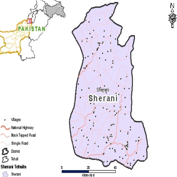
Map of Sherani District
Balochistan Districts
- Quetta District Profile
- Awaran District Profile
- Barkhan District Profile
- Bolan District Profile
- Chagai District Profile
- Dera Bugti District Profile
- Gwadar District Profile
- Harnai District Profile
- Jaffarabad District Profile
- Jhal Magsi District Profile
- Kalat District Profile
- Kech District Profile
- Kharan District Profile
- Khuzdar District Profile
- Killa Abdullah District Profile
- Killa Saifullah District Profile
- Kohlu District Profile
- Lasbela District Profile
- Loralai District Profile
- Mastung District Profile
- Musakhel District Profile
- Nasirabad District Profile
- Nushki District Profile
- Panjgur District Profile
- Pishin District Profile
- SheraniDistrict Profile
- Sibi District Profile
- Washuk District Profile
- Zhob District Profile
- Ziarat District Profile
Also visit: Sindh, Punjab, Khyber Pakhtunkhwa
Introduction/Geographical Details; Sherani District
Sherani district is located between 69° 31′ 53″ to 70° 02′ 55″ east longitudes, and 31° 16′ 44″ to 32° 04′ 15″ north latitudes. The district is bounded by South Waziristan Agency on the north, Dera Ismail Khan (D I Khan) district on the east, Musakhel district on the southeast, Zhob district on the south and west, and Afghanistan on the southwest. The district is named after the Sherani tribe, the largest tribe inhabiting the region.
Sherani District at a Glance
| Name of District | Sherani District | |
| Headquarters | Stano Raaghah Town | |
| Population[1] | 153,116 persons | |
| Area[2] | 2,710 km2 | |
| Population Density[3] | 51.9 persons/ km2 | |
| Growth Rate[4] | 3.4% | |
| Male Population[5] | 55.5% | |
| Female Population[6] | 44.5% | |
| Urban Population[7] | – | |
| Rural Population[8] | 100% | |
| Tehsils/ Talukas |
01 Tehsils: 1. Sherani Tehsil |
|
| Main Villages | Stano Raaghah town, Shin Bazai town, Astashai, Sher Ghali, Surlakai, Kili Khan Alam, Anzar Khezai, Aspasta Aghburga, Lehar Chopper Khail, Zara Killa, and Chajobi | |
| Literacy Rate[9] | 38.0% | |
| Male Literacy Rate[10] | 68.0% | |
| Female Literacy Rate[11] | 6.0 % | |
| Major Economic Activity[12] | Agriculture with its allied livestock breeding, fishing |
30.3%
|
| Community, Social & Personal Services | 32.3% | |
| Construction | 13.3% | |
| Wholesale, Retail, Hotel/Restaurant | 9.6% | |
| Electricity, Gas & Water | 8.4% | |
| Transport, Communication & Storage | 4.5% | |
| Others | 1.6% | |
| Main Crops[13] | Wheat, barley, rapeseed & mustard, jowar, maize, moong, maash, cumin, tobacco, and fodder | |
| Major Fruits[14] | Apples, almonds, apricots, grapes, peach, pomegranate, plums, watermelon, musk melon, sarda, and garma | |
| Major Vegetables[15] | Onions, potatoes, tomatoes, okra, tinda, radish, spinach, turnip, cabbage, carrot, pumpkin, cauliflower, peas, brinjal, chilies, and garlic | |
| Forest Area[16] | – HA[17] | |
| Black Topped Roads[18] | 627.0 km | |
| Shingle Roads[19] | 916.0 km | |
| Electricity | Supplied by Quetta Electricity Supply Company (QESCO) | |
| Telephone Exchanges[20] | There are 855 broadband connections | |
| Industrial Zones[21] | No Industrial Estate and no Industry | |
| Major Industry[22] | None | |
| Household Size[23] | 7.7 persons per house | |
| Houses with Piped Water[24] | 18.1% | |
| Houses with Electricity[25] | 34.8% | |
Table 1.1 Sherani District at a Glance
[1] 2017 Census
[2] 1998 Census only Sherani Tehsil.
[3] 2017 Census
[4] 2017 Census
[5] 2017 Census
[6] 2017 Census
[7] 2017 Census
[8] 2017 Census
[9] Pakistan Social & Living Measurement Survey 2014-15 (PSLM); Latest available
[10] PSLM
[11] PSLM
[12] 1998 Census (Zhob district); 2017 Census data has not been released yet.
[13] Data for Zhob has been used here, since data for Sherani district is not available.
[14] Data for Zhob district.
[15] Data for Zhob district.
[16] Balochistan Development Statistics 2018-19
[17] Land Utilization Statistics 6,277 HA under forests
[18] Balochistan Development Statistics 2018-19; Zhob District data
[19] Balochistan Development Statistics 2018-19: includes Zhob District as well
[20] Balochistan Development Statistics 2018-19; other data included in Zhob district
[21] Sherani District Development Profile 2011, P&D GoB, with UNICEF
[22] Sherani District Development Profile 2011, P&D GoB, with UNICEF
[23] 1998 Census (Zhob district); 2017 Census data has not been released yet.
[24] 1998 Census (Zhob district); 2017 Census data has not been released yet.
[25] 1998 Census (Zhob district); 2017 Census data has not been released yet.
Brief History – Governmental Structure – Administrative Divisions – Heritage Sites/ Tourist Attractions
Brief History of Sherani District
Sherani was a subdivision of Zhob district till 2006 when it was separated and given the status of a district. The history of Sherani district is, hence, the same as that of Zhob district and has been included in the chapter on Zhob.
There are 2 main tribes inhabiting the district: the Sherani tribe and the Harifal tribe.
According to the Imperial Gazetteer of India:
The Sherani country is a tract of land on the western border of Dera Ismail Khan District [now Khyber Pakhtunkhwa province]. It is bordered on the north by North Waziristan Agency, on the west by Balochistan and on the south by Ustrana Afghans.[1] The Suleiman Mountain Range running from north to south divides the country into two parts—“Largha” or lowlands and “Bargha” or the highlands. The country is poor with lowlands/largha being dependent upon agriculture whereas the Bar/Bargha Shiranis lead a pastoral life on the higher slopes of Takht-e-Suleiman[2] to which the flocks and herds of sections are sent in summers. (v. 22, p. 291)
The British, while fixing the borders of Zhob district, included the Bargha lands in Zhob district and the Largha lands in the tribal areas of Dera Ismail Khan district. Hence, the Sherani tribe (also spelled as Shiran or Sharani) tribe, resides in both areas.
The other major tribe inhabiting the district is the Harifal tribe. Both these tribes occupy the Suleiman Mountains and its subsidiary, the Shinghar Range. According to an academic hypothesis based on traditional/local knowledge (which is supported by the Zhob District Gazetteer), the Bargha lands were occupied by both the Wazirs/Bhittanis[3] and the Sheranis, about 400 years ago, who were in constant and protracted war with each other due to which the Bargha lands were notorious for being dangerous for non-local travelers and visitors for fear of attack.
Around the 17th century, the leader of the Sheranis met a Syed boy called Arif Ullah who had migrated from Pishin. The Sheranis sought his “supernatural” help and were victorious over the Wazirs/Bhittanis. Under Arif Ullah’s leadership, in fact, the Sheranis occupied the Bargha lands. Arif Ullah later married a Sherani woman, and became the progenitor of the Harifal tribe.[4] All Sheranis, out of courtesy, address every Harifal member with the title “Neeka” meaning grandfather, the highest level of reverence.
The Suleiman Mountains, locally known as Kase Ghar (abode of the Sherani and Harifal tribes) lie on the eastern boundary of Zhob district, and together with the other mountains, form a natural barrier between Afghanistan and the British Indian Empire. In order to keep the trade routes between Indian and Afghan territories open, it was essential for the British to secure passage by subjugating the tribes residing in the Zhob Valley and the mountains surrounding it.
According to the book, With the Zhob Field Force 1890 by Captain Crawford McFall, Major-General Sir George White, Commanding Officer of the British Army in India, set out for Zhob Valley from Loralai in 1889. This force entered Apozai (original name of Zhob) and made it their station. The only tribes who were hostile to the British were the Largha and Khiddarzai sections of the Sherani tribe. The Khiddarzai, in fact, refused to surrender 4 of their tribesmen to the British (who had accused these tribesmen of murder); Murtaza Khan (the leader of the Khiddarzai Sheranis) also refused to surrender.[5] A deputation of the leading “Maliks” (Cheiftains) of all other tribes had waited upon the Deputy Commissioner of Dera Ismail Khan at Sheikh Budin[6] in June 1989, but had been dismissed because of their being unable to guarantee the surrender of the “criminals”. In 1890, an expedition with Sir Robert Sandeman as Chief Political Officer and Major-General Sir George White as Commander was arranged to deal with the hostile tribes and the Zhob Field Force was formed. In addition to this, a detachment of the Punjab Frontier Force was also placed at the disposal of Sir George White to operate against the Sheranis from the direction of the Punjab and the Derajat to the east. The Khiddarzais were, thus, attacked from both directions: the Punjab and Balochistan.
Before the actual attack, a formal ultimatum was dispatched to Murtaza Khan and the other Khiddarzai chiefs, calling on them to surrender. The chiefs asked for a month to consider the matter. This was not acceptable to the British, and Sir Robert Sandeman instructed General White to attack the tribesmen.
The general plan was to send one column of the British army by Walla Nullah, over the Muramuzh Range, to Namur Kalan (the headquarters of the Khiddarzais), and the other column by way of the Chuhar Khel Dhana to Mogul Kot, while at the same time, a third force was to proceed to, and occupy, Drazand, the largest village of the Largha Sheranis.
The start from Apozai took place on October 31. By November 13, all the principal points in Sherani were occupied. Later, a grand inquest was held at Karama, to inquire into the conduct of the tribe; fines were imposed, and the proceedings were terminated by a darbar, at which the submission of the tribe was formally received by the British.
Some of the leaders of the Sherani tribe who fought against the British invasion were:
- Masho Khan Sherani: He harnessed the martial spirit of his tribe by forming a semi-military organization and his death made him a folk hero. He was killed during fighting against the British army in the Zhob district area called Silyazi
- Murtaza Khan Sherani, the chieftain of the Khiddarzai subtribe: His family is settled in Largha (lowland) of Sherani country. Prominent among his descendants is Malik Aslam Khan, settled in Dera Ismail Khan
- Sindhai Sherani: He is said to have fought along with Masho Khan. He was a Shamozai Hassankhail Sherani
- Berkhurdar: He was the commander of a fort on the west side of Spasta Valley as well as the village behind it. The fort had corner towers, and is known as Berkhurdar’s Fort. He is survived by a huge family commonly known as Ashak Kahool, which still lives in the same area
- Rani Gul: He is known for opening fire upon a British reconnoitering party in January 1888; he had a band of Khiddarzai under him
- Adam Khan Malezai Harifal: He was a close confidant of Masho Khan, and was arrested after Khan’s death, languishing in jail for an unspecified length of time. He was the resident of Tarai. He is survived by a grandson named Khanan in village Tarai
- Fazal Dirzai Harifal: He was a resident of Pehlan village. The British Government had offered a reward for his capture, but could neither arrest nor kill him. He ultimately migrated to Afghanistan
- Shikari Choharkhail, Lundak Dirzai Sherani, and Alamgul Hassankhail were other Sheranis known for their resistance to the British invasion. Lundak was a resident of Tarjana, who was later arrested and jailed
After annexation by the British, the Sherani’s homeland was made a part of the Sherani Agency and Zhob district; Captain MacIver was appointed the first Political Agent to Zhob and was the Political Agent of Sherani Agency also. The area became a part of Pakistan in 1947.
[1] Ustrana is a tribe that inhabits the hilly areas opposite the southernmost portion of Dera Ghazi Khan district and also parts of FR Dera Ismail Khan. They are descended from a Syed, who settled among the Sheranis, and married a Sherani woman. They are thus an intimate connection of the Sheranis
[2] Takht-i-Suleiman is a peak of Suleiman Mountains located in Drazinda, FR Dera Ismail Khan (FATA)
[3] Bhittanis is also spelled as Baitanis
[4] Wikipedia the free encyclopedia, Harifal tribe
[5] With the Zhob Field Force 1890 p. 122
[6] Sheikh Budin is a mountain range in Dera Ismail Khan district
Governmental Structure; Sherani District
At the Federal level, Sherani district is allocated a set number of representatives in both the National Assembly and the Provincial Assembly:
Under the Local Government Act 2010, Amended in 2011, Sherani district has 1 District Council with 13 Union Councils. It has 1 Municipal Committee as follows:
- Sherani
Each Union Council is represented by 1 member in the District Council. In addition, there is special representation of women (33%), and of workers and peasants (5% each).
[1] This seat is shared by Zhob and Kila Saifullah districts
[2] This seat is shared by Zhob district
Administrative Divisions; Sherani district
Sherani district covers an area of 2,710 km² and is subdivided into 1 Tehsil as follows:
| Sherani Tehsil | 07 Union Councils |
Table 1.2 Sherani Administrative Divisions
Historical/Heritage Sites and Tourism/Picnic Spots; Sherani District
Da Kase Ghar or the Takht-i-Suleiman is the only important[1] archeological site in the district. Locals believe that Qais Abdul Rasheed (575-661 AD), the progenitor of all Pashtoon tribes, was born, and is buried, here. This site, however, is not protected at present. The local population refers to this area as Da Kase Ghar (the mountain of Qais). His shrine, commonly called Shrine of Takht-i-Suleiman, is situated on a ledge below the crest on the southernmost bluff of Kase Ghar Mountain.
The Takht-e-Suleiman Area, with its Shrine and the Lake, has been earmarked for inclusion in the UNESCO National Heritage List.
In addition to the above, there are a number of mausoleums/mshrines which have historical importance and need to be protected under the Government of Pakistan laws. These are:
- Shrine of Hazrat Babakar Nika Harifal on Shinghar Mountains in Ghwanzah
- Shrine of Mulla Zaman Neeka,[2] Pashtoon, in Neekan Graveyard
- Shrine of MullahUmer Neeka Harifal at Killi
- Shrines of Abdul Haq and Mir Neeka at Karmanzai
[1] Sherani District Debelopment Plan 2011 by GoB and UNICEF
[2] Neeka is a title in Pashto that conveys more respect than father, akin to grandfather
Topography of Sherani District
Sherani district is mountainous in characteristics and comprises a mix of hills, valleys, and water channels. The terrain elevation varies from 678 to 3,356 m above mean sea level.
In the northeast of Balochistan plateau, Zhob and Sherani basin forms a lobe, surrounded on all side by mountains. The Sherani district is located within the Suleiman Mountain Range and the Shinghar Mountains; the slopes of the Suleiman Mountains are inhabited by the Sherani tribe whereas the Harifal tribe inhabits the slopes of Shinghar Mountains.
The Suleiman Mountains and Shinghar Mountains are separated by the valley of Lahar. The main peak of Shinghar is 2,826 m above sea level and the highest peak of Suleiman Mountains, called Takht-e-Suleiman or Solomon’s Throne (in Balochistan, it is called Da Kase Ghar or the mountain of Qais) is 3,487 m high. Both sister peaks (Shinghar and Da Kase Ghar) form the highest points of the Suleiman Range.
The Takht-e-Suleiman is a high tableland, bounded on its eastern and western edges by high, rugged, and steep parallel ridges. The western ridge culminates on the north in the peak of Da Kase Ghar (3,487 m) also spelled as Kaisagarh, and the eastern ridge ends in the block or detached headland of the Takht-e-Suleiman (3,374 m).
At each end, the Takht-e Suleiman tableland is rent by gorges which deepen, amidst precipices, to the channel of the Draband or Gat on the north, and the Dhana on the south.
Torghar is the continuation of the southern hills of the Suleiman Range, the highest peak of which is Charkundai, 2,291 m above sea level. Dhana Sir, the top of Dhana (1,189 m) is on a rough stony plateau.
Between Sherani Country and the Zhob district lie several small mountain ridges, across which the 3 chief passes are the Zarakni or Sheikh Haidar, the Draband, and the Chandwan. The Dhana Pass links the Sherani district with Dera Ismail Khan district. The actual length of the pass is 6.4 km. The pass/gorge gradually narrows from 18 m to a meter. The British constructed a road through this gorge, connecting Zhob/Sherani Country with Dera Ismail Khan.
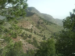
Figure 1.4 Shinghar Mountains
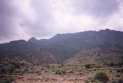
Figure 1.5 Suleiman Mountains
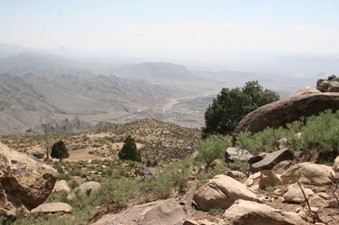
Figure 1.6 A View of Shinghar Mountains
Rivers, Streams, and Lakes; Sherani district
The main springs of the district include the Pezai spring on the western slopes of the Suleiman Mountain Range, the Cheena spring, Salaizai Cheena, and Samazai Cheena. There are a number of intermittent and perennial streams that flow down from the mountains; an important perennial stream is the Sherani Lahar. Some of the intermittent streams include Band Algad, Tawa Khwazah, Pasta Khwara, Tora Khwara, Tangai Sheela, and Lakarai.
Forests; Sherani district
The district contains Natural Dry Temperate Forests consisting of chilghoza pine and Sub Tropical Broad Leaved Evergreen Scrub[1] Forests of olive and phulai, which occupy large areas in the district. The district has a reasonable area under forest, and a statistically negligible area has been conserved as State Forest. There are 5 Notified Forests in the district; these are Kapip, Shahwan Khawe, Shinghar, Khawaza, and Merhail, with a total forest area of 6,277 HA[2]. The remaining forest area is community-owned and these forests are not under any scientific management regime.
In the Dry Temperate Forests of chilghoza pine, the main species are chilghoza (Pinus gerardiana), blue pine (Pinus wallichiana), olive (Olea ferrugenea), shina or Bombay mastix (Pistacia khinjuk), uzhgai or wild pistachios (Pistachia cabulica), gurgura or ganger (Reptonia buxifolia), shang/wild ash (Fraxinus xanthoxyloides), and wild almond (Prunus eburnean). In the Sub Tropical Broad Leaved Evergreen Scrub Forests, the main tree species are: natural olives (Olea ferrugenea), and phulai (Acacia modesta). Besides these tree species, a number of associated shrubs and herbs are also present in these forests, which may include barara or milk broom (Periploca aphylla), anang or sour cherry (Prunus creasus), arghuch or viper’s grass (Scorzonera mollis), datura or devil’s trumpet (Datura fastuosa), gandarae or oleander (Narium odorum), gangu (Othonnopsis intermedia), ghuzera or dwarf sophora (Sophora grifithii), injaora or round headed leek/garlic (Allium sphaerocephalum), khamazurgae or Indian rennet (Withania cougulans), khatol or African mustard (Malcolmia africana), malaghunae or olive daphne (Daphne oleoides), mazri or dwarf palm (Nannorrhops ritchiana), and sanatha (Dodonea viscose; Sanatha is usually found on degraded sites). The ground cover is constituted mainly by feather grass (Stipa pennata), fountain grass (Pennisetum orientalis), Aucher’s grass (Chrysopogon aucheri), barau or Johnson’s grass (Sorghum halepense), barwaza or spear grass (Heteropogon contortus), bushkae or hoary cress (Sepidium draba), and Sargarae or lemongrass (Cymbopogon sp.).
Soils; Sherani district
In the absence of any other data, details for soils of the district have been taken to be the same as those for Zhob district. The soils of the Zhob Valley are loamy, deep, and strongly calcareous, whereas the mountains have shallow soil.
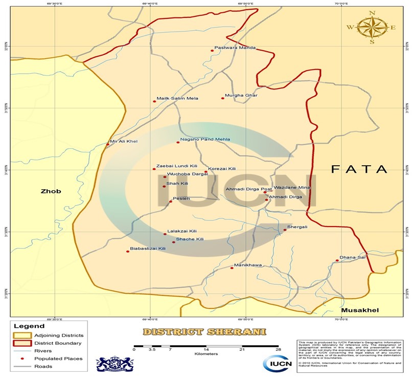
Figure 1.7 IUCN GIS Map Sherani District
Climate of Sherani district
In the absence of any other data, the climate of the district is taken to be the same as that of Zhob district, which is generally hot in the summer and cold in the winter. Summer is from May to September, and June is the hottest month, with mean maximum and minimum temperatures being 37 °C and 23 °C respectively. January is the coldest month, with mean maximum and minimum temperatures ranging between 13 °C and ‑1 °C. Dust storms occur in summer from July to September, some of which are accompanied by thunder storms. In winters, the wind blows from the west and is very cold. The winds from the southwest and the east are also common, and these often bring rain. The winds from the north occasionally blow in September to April, and bring drought, damaging standing crops.
Rainfall is scanty, and varies with the altitude. Most of the rainfall is received during the winter months. Mean annual rainfall of the district is 285 mm.
Seismic Activity; Sherani district
The district belongs to Zone 3 of the Seismic Zone Map of Pakistan, which means moderate to severe damage due to earthquakes.
[1] Sherani District Development Profile 2011 P&D Department GoB with UNICEF
[2] Not reported in the Forestry Statistics.
Population of Sherani District
The following table shows the population of the district according to 2017 Census:
| District/Tehsil |
Area km2 |
Population | Male% | Female% | Urban % | Growth Rate % |
| Sherani District | 2,710 | 153,116 | 55.5 | 44.5 | – | 3.36 |
| Sherani Tehsil | 2,710 | 153,116 | 55.5 | 44.5 | – | 3.36 |
Table 1.3 Sherani Population Statistics
Religions; Sherani district[1]
| Muslims | 99.7% |
| Christians | Negligible % |
| Hindus | Negligible % |
| Ahmadis | 0.2% |
| Scheduled Castes | Negligible % |
| Others | Negligible % |
Table 1.4 Sherani Religions
Languages; Sherani district[2]
| Urdu | 0.2% |
| Punjabi | Negligible % |
| Sindhi | Negligible % |
| Pushto | 99.7% |
| Balochi | Negligible % |
| Seraiki | Negligible % |
| Others[3] | Negligible % |
Table 1.5 Sherani Languages
[1] 1998 Census (Sherani tehsil); 2017 Census data has not been released yet.
[2] 1998 Census (Sherani tehsil)); 2017 Census data has not been released yet.
[3] Includes Brahui etc.
Economic Activity – Economic Infrastructure
Economic Activity; Sherani District
The main economic occupations of Sherani have been taken to be the same as Zhob district, which are as follows:
- Agriculture with its allied livestock breeding, fishing (30.3%)
- Community, Social & Personal Services (32.3%)
- Construction (13.3%)
- Wholesale, Retail, Hotel/Restaurant (9.6%)
- Electricity, Gas & Water (8.4%)
- Transport, Communication & Storage (4.5%)
- Others (1.6%)
Land Use; Sherani district
The following table shows the main land use statistics of Sherani district according to Balochistan Development Statistics 2018-19:
| Total Area | 271,000 HA | Reported Area | 12,751 HA |
| Total Cultivated Area | 6,474 HA | Net Sown | 1,902 HA |
| Current Fallow | 4,572 HA | Total Uncultivated Area | 6,277 HA |
| Culturable Waste | – HA | Forest Area | 6,277 HA |
Table 1.6 Sherani Land Use Statistics
Agriculture; Sherani district
Like Zhob district, Sherani is included in the Western Dry Mountain Agro-Ecological Zone of Pakistan; farming is mostly barani or rain fed/ torrent fed. The crops of the district are wheat, barley, rapeseed & mustard, jowar, maize, moong, maash, cumin, tobacco, and fodder.
The fruits grown in the district are apples, almonds, apricots, grapes, peach, pomegranate, plums, watermelon, musk melon, sarda, and garma.
The vegetable produce of the district includes onions, potatoes, tomatoes, okra, tinda, radish, spinach, turnip, cabbage, carrot, pumpkin, cauliflower, peas, brinjal, chilies, and garlic.
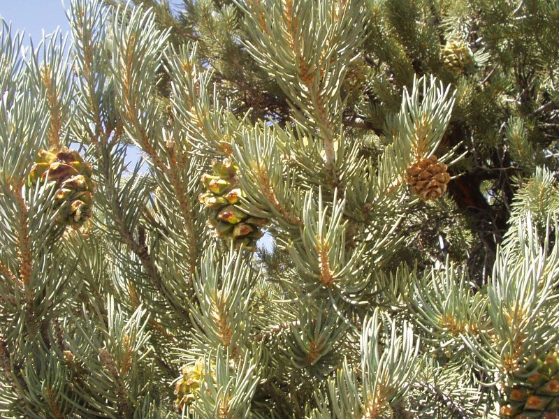
Figure 1.8 Chilghoza Foliage
Livestock Breeding; Sherani district
Livestock breeding is a very important sector of the economy. It is the main source of income for nomadic families. The following table shows the position of the Livestock Population for Zhob district according to the 2006 Census of Livestock (qtd. in Balochistan Development Statistics 2018-19) and includes data for Sherani district:
| Cattle | 178,658 Heads | Buffaloes | 5,524 Heads | Sheep | 1,174,735 Heads |
| Goats | 875,922 Heads | Camels | 1,010 Heads | Horses | 370 Heads |
| Mules | 168 Heads | Asses | 18,351 Heads |
Table 1.7 Sherani Livestock Statistics
The livestock breeds of the region are kohi (camel); Koh-i-Suleiman or lohani (cattle); shinghari and sperki or pidie (donkey); Balochi (horse); kakari, Musakhaili, kajjale and bibrik (sheep); and Koh-i-Suleimani (goat).
Poultry Farms; Sherani district
According to the Balochistan Development Statistics 2018-19, there are 303,912 poultry birds in Zhob district (projected population); this includes data for Sherani district also.
Fishing; Sherani district
Commercial Fisheries are not present in the district and people do not fish regularly, but fish like Rohu, Morki, Thella and Mali are found in cold and mildly cold areas of Zhob, and Trout has high fishing potential. After the construction of Murghabal Dam is completed, the fisheries sector can be developed in the region.
Bee Keeping/Apiary; Sherani district
Bee keeping is not an economically significant activity in the district. Local people collect honey from wastelands and forest areas for their own use.
Irrigation Network; Sherani district
Sherani district belongs to the Western Dry Mountains Agro-Ecological Zone of Pakistan, which is the same as Zhob district. The district mostly comprises of barren mountains with steep slopes and is mostly barani and rainfed. The following table shows the mode of irrigation and area being irrigated by the mode (Balochistan Development Statistics 2018-19):
| Total Irrigated Area | 1,839 HA | Government Canals | – HA |
| Private Canals | – HA | Wells | – HA |
| Tube wells | 613 HA | Karez/Spring/Others | 1,226 HA |
Table 1.9 Sherani Irrigation Statistics
Irrigation canals off-taking from Sabakzai Dam on Sawar Rud (a tributary of River Zhob) and the river itself are the main canals irrigating the district.
Murghabal Delay Action Dam is being built in the district.
Minerals and Mining; Sherani district
There are no minerals in the district.[1]
Industry; Sherani district
There are no industrial units in the district.[2]
Handicrafts; Sherani district
The main handicrafts of the district are embroidery on clothes, and sandal and shoe making, as well as embroidery of leather. This embroidery is mostly done by women, and is taken to be the same as data from Zhob district.
[1] Sherani District Development Plan 2011, by GoB and UNICEF
[2] Sherani District Development Plan 2011, by GoB and UNICEF
Economic Infrastructure; Sherani District
Roads are the most important means of transport in the region, and form the backbone of the economy. The district is not linked through rail or air.
Road Statistics; Sherani district
According to the Balochistan Development Statistics 2018-19 the road statistics[1] of the district are as follows:
| Total Roads | 1,544.0 km |
| High Type Roads/black topped | 627.0 km |
| Low Type Roads/Shingle | 916.0 km |
Table 1.8 Sherani Road Statistics
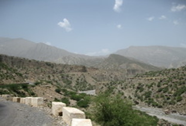
Figure 1.10 Zhob-D I Khan Road
Rail and Airways; Sherani district
There is no rail link to the district. The nearest railway station is at Zhob; Zhob also has a small airport, called Zhob Airport, which is the airport closest to Sherani district.
Radio and Television; Sherani district
There is no radio station or TV booster in the district, but radio can be accessed fairly easily. Radio is a major source of entertainment especially in the rural areas.
Telecommunications; Sherani district
The district is connected to other parts of the country through telephone and telegraph. There are no telephone exchanges,[2] but there are 802 broadband connections in the district. Cellular phone companies also provide their services in the district.
Post Offices/ Courier Services; Sherani district
There is 1 post office in the entire district (Balochistan Development Statistics 2018-19). Courier companies provide services in the district as well.
Banking/Financial Institutions; Sherani district
Data is not available.
Electricity and Gas; Sherani district
Quetta Electric Supply Company (QESCO) looks after the supply and transmission of electricity to the district.
Educational Institutions; Sherani district
Following table gives the number of primary, middle secondary, mosque schools in the district as per Balochistan Development Statistics 2018-19:
| Institution | Boys/Girls | Institution | Boys/Girls |
| Primary Schools | 158/18 | Middle Schools | 10/02 |
| High Schools | 05/01 | Community Schools | 08 |
| Higher Secondary | 01/01 | Degree Colleges | -/- |
| Universities | – | Mosque Schools[3] | * |
| Vocational Training Schools | – | Private Schools | – |
Table 1.10 Sherani Educational Institutes
Healthcare Facilities; Sherani district
The following table shows the Government Health Care Institutions in Sherani district as per Balochistan Development Statistics 2018-19:
| Institution | No./beds | Institution | No./beds |
| Teaching Hospitals | – | Hospitals | -/- |
| Rural health Centers | 02/32 | Basic Health Units | 07/- |
| Dispensaries | 07/- | Mother Child Health Centers | 01/- |
| TB/Leprosy clinics etc | – | Private Hospitals | – |
| Private dispensaries | – |
Table 1.11 Sherani Health Institutes
Policing; Sherani district
The larger part of Bolan district is bifurcated into an “A” and “B” areas. The “A” area, comprising towns and highways, has a police force. “B” area does not have a police force. All major law and order matters in the “B” area are dealt with by levies.
Levy is a conventional force for maintaining law and order, and were installed during British rule. Levy members are recruited along tribal or clan lines. The levies fall under the direct command of the Deputy Commissioner (DC), with powers delegated to the assistant commissioners, and tehsildars. Every district in Balochistan has its own levies, named after the district. Recently, at the initiation of the DC administration, a new levy force has been recruited on district level, known as the Task Force. This Task Force is better trained and equipped with advanced weapons.
The policing of Sherani district is looked after by the Regional Police Officer (RPO) Loralai. This RPO is assisted by 1 SubDivisional Police Officer (SDPO) stationed at Sherani. In all, there are 2 police stations[4] in the district.
Figure 1.11 A Check Post on Shinghar Mountains
[1] Includes data for Zhob District also
[2]Balochistan Development Statistics, 2018-19
[3] included in primary schools
[4] Table no. 19.7 (a) Number of Police Stations by Division/District; by Federal Bureau of Statistics.
Environment and Biodiversity; Sherani District
The district is free from air pollution, as there is very little heavy traffic on roads and no industry. Potable water is also a scarcity.
Flora and Fauna; Sherani district
Flora; Sherani district
There are 3 vegetation zones[1] in the district, as follows:
- Hills: The region has chilgoza pine (Pinus gerardiana) with associates like blue pine (Pinus wallichiana), olive (Olea ferrugenea), shina or wild pistachios (Pistacia khinjuk), uzhgai or wild pistachios (Pistachia cabulica), gurgura or ganger (Reptonia buxifolia), shang/wild ash (Fraxinus xanthoxyloides), and wild almond (Prunus eburnean)
- Foothills: The foothills host olive (Olea ferrugenea), phulai (Acacia modesta), sanatha (Dodonea viscosa), kandiari (Gymnosporia spinosa), ber (Zizyphus nummularia), and mazri or dwarf palm (Nannorrhops ritchiana)
- Plains and Streambeds: These are commonly found in the entire district where Tamarix sp. and Saccharam sp. are common.
Fauna; Sherani district
Mammals found in the district include fox, Asiatic jackal, cape hare, stone marten, porcupines, Afghan hedgehog, Suleiman markhor, and urial.
Avifauna includes chakor, see-see partridge, magpie, houbara bustard, a number of sparrows, finches, buntings, seasonal/ migratory waterfowls, hawks, and sand grouse. The area also provides a corridor to migratory bird species like the common crane and Demoiselle crane.
Reptiles include Afghan tortoise, brown cobra, saw-scale viper, Levantine viper, and goh.
Protected Areas and Wildlife; Sherani district
There are no Protected Wildlife Areas in the district. There are no wetlands of national or international importance located in the district either. The Sherani Lahar (semi-perennial river), throughout its length, is an important wetland for resident and winter visiting species. The major birds found in the region are cranes, pelicans, king fishers, and osprey.
[1] Sherani District Development Plan 2011, by GoB and UNICEF