Share now
Map of Balochistan

Map of Lasbela District

Balochistan Districts
- Quetta District Profile
- Awaran district Profile
- Barkhan District Profile
- Bolan District Profile
- Chagai District Profile
- Dera Bugti District Profile
- Gwadar District Profile
- Harnai District Profile
- Jaffarabad District Profile
- Jhal Magsi District Profile
- Kalat District Profile
- Kech District Profile
- Kharan District Profile
- Khuzdar District Profile
- Killa Abdullah District Profile
- Killa Saifullah District Profile
- Kohlu District Profile
- Lasbela District Profile
- Loralai District Profile
- Mastung District Profile
- Musakhel District Profile
- Nasirabad District Profile
- Nushki District Profile
- Panjgur District Profile
- Pishin District Profile
- Sherani District Profile
- Sibi District Profile
- Washuk District Profile
- Zhob District Profile
- Ziarat District Profile
Also visit: Sindh, Punjab, Khyber Pakhtunkhwa
Introduction/Geographical Details Lasbela District
Lasbela district is located between 24° 53Ꞌ 02” to 26° 39Ꞌ 20” north latitudes and 65° 12Ꞌ 11” to 67° 25Ꞌ 39” east longitudes. It shares its borders with district Khuzdar in the north and the Arabian Sea in the south. Dadu, Malir, and Karachi West districts of Sindh province are located along the district’s eastern border, while the western border is shared with Gwadar and Awaran districts of Balochistan.
The name Lasbela is derived from two words: ‘Las’ which signifies a plain (the greater part of the area is a flat plain), and ‘Bela’ which means jungle. Bela is also one of the principal towns of the district.
Lasbela District at a Glance
| Name of District | Lasbela District | ||
| Headquarters | Uthal Town | ||
| Population[1] | 574,292 persons | ||
| Area[2] | 15,153 km2 | ||
| Population Density[3] | 40.7 persons/ km2 | ||
| Growth Rate[4] | 3.2% | ||
| Male Population[5] | 52.1% | ||
| Female Population[6] | 47.9% | ||
| Urban Population[7] | 48.6% | ||
| Tehsils/ Talukas | 05 Tehsils:
1. Bela Tehsil 2. Uthal Tehsil 3. Hub Tehsil 4. Gaddani Tehsil 5. Dureji Tehsil |
||
| Main Towns | Hub, Uthal, Bela, Gaddani, Gondrani (Cave City), Chhor, Sonmiani, Kanrai, Windar, Hubco, Dureji, Lakhara, Welpat, Kathore, and Khanwari | ||
| Literacy Rate[8] | 42% | ||
| Male Literacy Rate[9] | 52% | ||
| Female Literacy Rate[10] | 31% | ||
| Major Economic Activity[11] | Agriculture, Forestry, Hunting & Fishing | 35.4% | |
| Community, Social & Personal Services | 19.5% | ||
| Construction | 12.6% | ||
| Electricity, Gas & Water | 11.8% | ||
| Others | 20.8% | ||
| Main Crops | Wheat, barley, jowar, bajra, maize, sesame, castor seed, moong, guar seed, cotton, sugarcane, rice, moath, sunflower, canola, maash, and gram | ||
| Major Fruits | Mangoes, citrus, banana, guavas, dates, papaya, coconuts, watermelon, musk melon, and chikoo | ||
| Major Vegetables | Onions, tomatoes, okra, radish, spinach, cabbage, carrots, bitter gourd, bottle gourd, pumpkin, cauliflower, peas, beetroot, brinjal, luffa, cucumber, chilies, coriander, peas, and broad bean | ||
| Forests (Area)[12] | 123,326 HA[13] | ||
| Black Topped Roads[14] | 1,362.0 km | ||
| Shingle Roads[15] | 1,232.0 km | ||
| Electricity[16] | Supplied by Karachi Electric Supply Corporation (KESC, now Karachi Electric, or KE). There is only one Grid Station at Uthal. Electricity to the Industrial Estates is provided by Lasbela Industrial Estate Development Authority (LIEDA) | ||
| Telephone Exchanges[17] | 05 telephone exchanges with 1,639 landlines, 569 wireless phones and 1,539 broadband connections | ||
| Industrial Zones[18] | 6 Industrial Estates in the district:
1. Hub Industrial and Trading Estate (HITE) 2. Marble City, Gaddani (MCG) 3. Windar Industrial & Trading Estate (WITE) 4. Special Industrial Zone, Windar (SIZ Windar) 5. Uthal Industrial Estate (UIE) 6. Uthal Industrial Estate II (UIE II) |
||
| Major Industry[19] | Textile | 24 Units | |
| Chemical/Pharmaceuticals | 22 Units | ||
| Engineering | 18 Units | ||
| Food/Beverages | 16 Units | ||
| Steel | 13 Units | ||
| Household Size[20] | 6.4 persons per house | ||
| Houses with Piped Water[21] | 12.9% | ||
| Houses with Electricity[22] | 28.9% | ||
Table 1.1 Lasbela District at a Glance
[1] 2017 Census
[2] 1998 Census
[3] 2017 Census
[4] 2017 Census
[5] 2017 Census
[6] 2017 Census
[7] 2017 Census
[8] Pakistan Social & Living Measurement Survey 2014-15 (PSLM); Latest available.
[9] PSLM
[10] PSLM
[11] 1998 Census; 2017 Census data has not been released yet.
[12] Balochistan Development Statistics 2018-19
[13] Land Utilization Statistics report 166,797 HA under forests.
[14] Balochistan Development Statistics 2018-19
[15] Balochistan Development Statistics 2018-19
[16] Balochistan Development Statistics 2018-19
[17] Balochistan Development Statistics 2018-19
[18] Lasbela District Development Profile 2011, P&D, GoB, with UNICEF; Latest available.
[19] Lasbela District Development Profile 2011, P&D, GoB, with UNICEF; for a detailed list, please see the section on Industry.
[20] 1998 Census; 2017 Census data has not been released yet.
[21] 1998 Census; 2017 Census data has not been released yet.
[22] 1998 Census; 2017 Census data has not been released yet.
Brief History – Governmental Structure – Administrative Divisions – Historical/Heritage Sites and Picnic Areas
Brief History Lasbela District
Lasbela was a Princely State in subsidiary alliance with the British Government; it became a Princely State in subsidiary alliance with Pakistan at the time of Partition, and remained as such until 1955, when it was made a part of West Pakistan under the One Unit Scheme.
It is known that Alexander the Great passed through Lasbela on his way back from conquering India; according to the accounts of his march given by Sir Thomas Holdich,[1] he left Patala (now Thatta) in Sindh in the beginning of September, 326 BC,[2] retreating from India through Makran and Lasbela. After Alexander’s death, one of his generals, Seleucus Nicator, became the ruler of central and western Asia including Balochistan (which included Lasbela). In 305 BC Seleucus Nicator was defeated by Chandragupta Maurya and was forced to cede Lasbela, Makran, and several other areas to him. For many centuries after this, nothing can be traced about the history of Lasbela.
It is known that in the 7th century AD the ruler of Armanbel (which is believed to be the present town of Bela) was a Buddhist ruler, called Somani, who was a descendant of the governors of Rai Sahiras, the King of Hind (India). The Rai had elevated[3] Somani to this position for his loyalty and devotion. Raja Chach, the father of Raja Dahir, usurped the throne of the Rai dynasty of Sindh and marched to Bela in 636 AD with a view to demarcate the boundary of Kirman (Iran) and also to gain the allegiance of the outlying province. From Bela, Chach marched west toward Makran.
Lasbela district was also located on the route taken by the Arab General, Muhammad Bin Qasim, to conquer India. Qasim entered Makran in 712 AD; at that time, Makran and Bela were governed by Muhammad Ibn Haroon. When Muhammad Bin Qasim arrived in Makran to proceed toward Sindh, Muhammad Ibn Haroon accompanied him. Muhammad Haroon died in Bela, and his tomb is still there. The power of the Arabs in the area lasted till the end of the 10th century.
The district appears to have come under the influence of the Soomras and Sammas, who asserted their independence when the power of the Abbasid caliphs (Arabs) declined in the 10th century; the Soomras gained a position of supremacy in the middle of the 11th century. They were eventually overthrown by the Sammas led by Jam Umar in 1333. The Sammas reigned till 1523, when they were defeated, and their power completely broken by Shah Hussein Arghun. The succeeding period is again obscure. The chiefs of the Gujar, Ranjha, Gunga, and Burfat tribes, who still inhabit Lasbela, are said to have exercised a semi-independent power preceding the rise of the Aliani family of the Jamoot tribe, who are the founders of the Lasbela State.
There is little record of any these chiefs, but it is known that the last two of the Gunga Chiefs were Jam Dinar and Jam Ibrahim. Owing to a quarrel over the division of certain plundered property, the head of his own tribe murdered Jam Ibrahim. To avenge the death of Jam Ibrahim, his uncle, Pahar Khan, the Chief of the Burfat tribe, attacked and subdued the Gungas in the vicinity of Uthal. According to the Baluchistan District Gazetteer Lasbela,
Pahar Khan then ruled Bela and after him the chieftainship descended to Mir Izzat Khan and to his son. As the latter was a minor, the authority was vested in Bibi Chaguli, his mother. But Jam Ali, Sardar of the Jamot tribe, applied to Muhabbat Khan, Khan of Kalat, to assist him in taking Bela. (p. 25)
Muhabbat Khan dispatched a force comprised mainly of Brahuis, led by Mulla Muhammad Hayat (an Akhund) to Bela. With his assistance, Jam Ali succeeded in taking over Bela and establishing his authority in 1742. The Khan of Kalat took a half share of all revenues of Bela, but handed over the chieftainship and the other half share of revenues to Jam Ali. The chieftainship of Lasbela has since remained in this family. The Jamoot tribe claims descent from Abdul Manaf of the Qureshi tribe of the Arabs.[4]
Jam Ali Khan I (with surname Kathuria) ruled until his death in 1766. His eldest son, Jam Ghulam Shah, succeeded him, but died of small pox in 1776 in Kalat. His remains were brought to Bela, where he was buried. The remains of his tomb still exist in Sanjarwala Garden near Gondrani.
The Aliani family of the Jamoot tribe continued to rule Lasbela till 1955. The Jamoot rulers of Lasbela were:
- Jam Ali Khan I (surname Kathura; 1742-1765)
- Jam Ghulam Shah (1765-1776)
- Jam Mir Khan I (1776-1818)
- Jam Ali Khan II (1818-1830)
- Jam Mir Khan II (1830-1869)
- Jam Ali Khan III (1869-1896)
- Jam Mir Kamal Khan (1896-1921)
The most prominent of these Jams was Jam Mir Khan II; he allied himself with the Jams of the Jhalawan Country in three rebellions against Mir Khudadad Khan, the Khan of Kalat. In 1869, when the Jam was marching toward Kalat with a large force, a clash was averted by the intervention of the British Political Officer. The negotiations were, however, abortive; Jam Mir Khan refused to pay allegiance to the Khan of Kalat and was banished to British India. In 1877, he was restored to the masnad (throne) after signing a treaty to acknowledge the sovereignty of the Khan of Kalat. He died in 1888, and the British appointed a wazir (minister) to assist his successor Jam Ali Khan III.
Jam Mir Khan III was, at first, inclined to let his son Jam Ali Khan carry on the government, but ultimately took the administration of the region in his own hands. Jam Mir Khan III died in January 1888, leaving three sons. His eldest son, Haji Jam Ali Khan was installed at Bela in January 1889 by Sir Robert Sandeman, the British Agent to the Governor General in Balochistan. Sir Robert died on January 29, 1892 in Bela; his tomb is in Bela Gardens.
Haji Jam Ali Khan died in 1894 and was succeeded by his son, Jam Mir Kamal Khan, who subsequently ruled over the state for 50 years. His successors, first his son, Jam Mir Ghulam Muhammad Khan, and later his grandson, Jam Ghulam Qadir Khan continued to hold the masnad under the same conditions, and without any significant events until Pakistan was founded on 14 August, 1947. At this time, Lasbela, along with Kharan and Kalat States, acceded to Pakistan, and later became part of the Balochistan province.
The statement of Ghulam Qadir Khan, the last Jam of Lasbela, on signing the treaty of accession was:
We hold historical ties with Sindh and share strongest cultural bond with the Province. Our People have accepted Jinnah Sahab as the leader of new Muslim homeland and we vote to merge in Pakistan.
In October 1952, Balochistan States Union was formed by the States of Kalat, Lasbela, and Makran, with the capital at the town of Kalat. The area covered by this Union was roughly the western half of the modern province of Balochistan. The Union was separate from the Chief Commissioners Province of Balochistan, which comprised areas to the northeast of the Union, and consisted of the present-day districts of Quetta, Pishin, Jaffarabad, Zhob, Chagai, Dera Bugti, and Kohlu.
In October 1955, the unification of the provinces of Punjab, NWFP, Sindh, and Balochistan took place under the One Unit Policy, and West Pakistan was formed. The Balochistan States Union was re-formulated as the Kalat Division. In December 1960, Lasbela became a separate district, and was placed as a part of the Karachi Division. It was transferred to the Kalat Division of Balochistan province in the 1970s.
Governmental Structure Lasbela District
At the Federal level, Lasbela district is allocated a set number of representatives in both the National Assembly and the Provincial Assembly:
- Number of seats in the National Assembly 1
- Number of seats in the Provincial Assembly 2
Under the Local Government Act 2010, Amended in 2011, Lasbela district has 1 District Council with 22 Union Councils. It has 6 Municipal Committees as follows:
- Uthal
- Bela
- Hub
- Windar
- Dureji
- Gadani
Each Union Council is represented by 1 member in the District Council. In addition, there is special representation of women (33%), and of workers and peasants (5% each).
Administrative Divisions Lasbela District
Lasbela district covers a total area of 15,153 km2 and is divided into the following tehsils named after their headquarters:
| Bela Tehsil | 05 Union Councils |
| Hub Tehsil | 07 Union Councils |
| Uthal Tehsil | 06 Union Councils |
| Gaddani Tehsil | 02 Union Councils |
| Dureji Tehsil | 02 Union Councils |
Table 1.2 Lasbela Administrative Divisions
[1] Imperial Gazetteer of India v. 6, p. 275
[2] Balochistan District Gazetteer Series Lasbela, p.19
[3] District Gazetteer Lasbela 1907
[4] 1998 Lasbela District Profile by GoPakistan..
Historical/Heritage Sites and Picnic Areas Lasbela District
The following historical buildings are protected under the Government of Pakistan Laws:
- Ancestral graveyard of Jam of Lasbela in Babrs Lasbela: This necropolis is located 8 km from Lasbela at Bara Bagh. It includes tombs of the former rulers of Lasbela. This necropolis contains more than 100 tombs, of which 40 belong to the royal family of the Koreja Jams
- Tomb of General Muhammad Ibn-e-Haroon, Bela town, Lasbela: General Haroon was the governor of Makran, who accompanied Muhammad Bin Qasim in 712 on his way to Sindh. General Haroon died in Bela and his tomb is still extant
- Tombs at Hanidan, Pir Mubarakm,[1] Lasbela: This graveyard is located near Dureji, and contains tombs similar in design to those at Choukhandi
- Choukhandi (Rumi) Graves, Bhawani Sarai, Lasbela: The tombs are located 8 km from Hub Chowki, and are attributed to theJokhio (also spelt Jokhiya) tribe. This graveyard is believed to be the family graveyard of the Jokhio tribe, although other, mainly Baloch, tribes have also been buried here. The tombs were mainly built during Mughal rule, during the 15th and 18th centuries
Following are important heritage buildings in the district which also need to be protected by Pakistani Laws:
- Shah Jamia Mosque: Constructed in 1836, the mosque is located in Bela town. It was built by Jam Mir Khan II, and its architecture is based on the Central Asian style of the 14th century
- Tomb of Colonel Robert Sandeman: Made of granite and white marble, the tomb is surrounded by gardens
- Tombs/ ruins of Karia Pir near Bela Town: These ruins contain Arab pottery, seals, and other medieval relics
- Sassi Waro-Chodo (Sassi’s Spring): This is located near Paboni Naka, about 68 km from Karachi
- Bakkar Buthi: This is a small Harappan site located in the remote mountainous area to the east of the Lasbela plain. It comprises of a fortified southern part as well as some houses and working spaces for the processing of chert (a sedimentary rock) to the north. Two trenches dug in 1998 revealed several phases of houses on a thick deposit of alluvial sediments. While the lower mud brick and stone walls are well-built, the uppermost occupation is less sophisticated. Occupation is dated to between 2400 and 2000 BC by radiocarbon dates. Apart from typical Harappan objects, some Kulli[2] elements are also present
- Mai Pir or Gondrani: This location is also called Sheher-e-Roghan or the town of Mai Gondrani, located 20 km from the town of Bela. This is a man-made cave city, and is one of the largest cave cities in the world. There are about 200 man-made chambers, each with a verandah and one room carved into a relatively vertical cliff in conglomerate formation. Recent studies of materials found around the cliff, like chert blades and coarse handmade pottery, indicate that these caves were built in the Neolithic period, about 6000 BC[3]
- Shrine of Shah Bilawal Noorani, and Lahut-i-lamakan: Both shrines are situated in Shah Bilawal village, west of the Tira Hub stream
- Kumb Shireen and tombs of Shireen and Farhad: The Kumb Shireen spring is located on the western slope of the Haro or Hala Hills on the route between Awaran and Karachi, which passes through Lasbela over the Jau-Lak. The tomb of Shireen and Farhad is also located in the area; they are buried in a single grave. Shireen and Farhad are the main protagonists of a folk love story. A fair is held here every year
- Shrine of Pir Fida Hussain, Uthal: An Urs is held annually
- Shrines of Pir Moosiani and Pir Mohiuddin
- Hinglaj: This is aHindu temple in Hinglaj, a town on the Makran coast in the Lasbela district, and is located in the middle of the Hingol National Park. The shrine is located in a small natural cave. There is a low mud altar. There are no man-made images of the goddess, and instead, a small shapeless stone is worshipped as Hinglaj Mata. The stone is smeared with Sindoor (vermilion), which possibly gives the location its Sanskrit name Hingula, which is the root of the present-day name (Hinglaj)
- Shrines of Pir Koonana, Pir Shah Bukhari, Pir Meeran, Pir Bukur, and Darga Baba Juman Shah Uthal
These sites are also tourist attractions, especially if developed and restored properly. These also provide avenues for a recreational picnic. Hub Dam Reservoir and Miani Hor, Gadani Beach, and Sonmiani beach also provide great places for picnics and recreational outings.
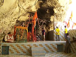
Figure 1.10 A Hinglaj Mata Mandir (Temple) Hingol National Park, Lasbela
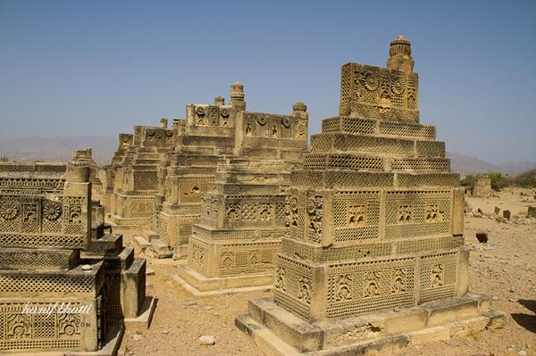
Figure 1.11 Hanidan Graveyard
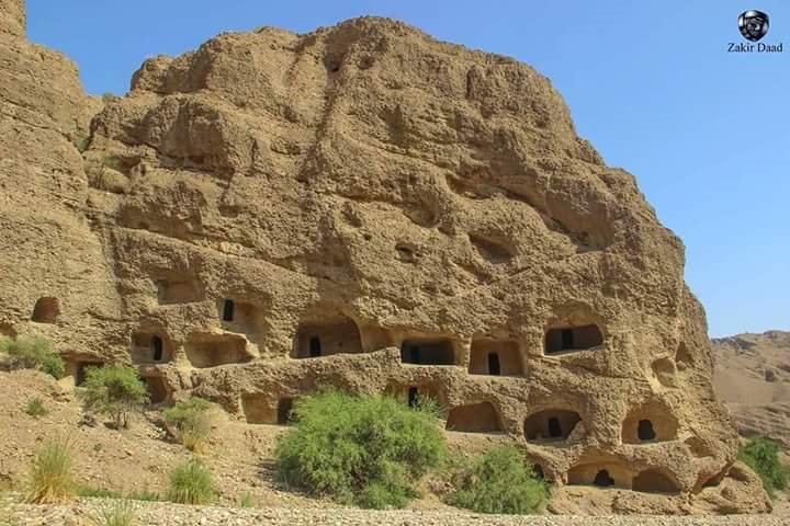
Figure 1.12 A view of Mai Pir or the Cave City
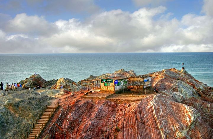
Figure 1.13 A view of Gadani Beach
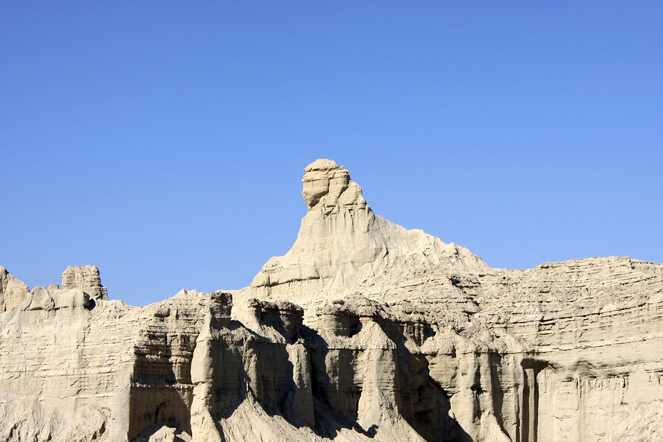
Figure 1.14 Balochistan Sphinx, a natural rock formation, Lasbela
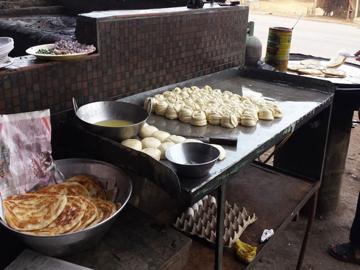
Figure 1.15 A Roadside Café, Windar, Lasbela
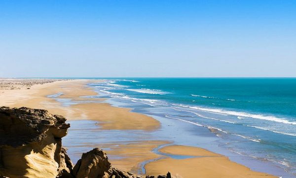
Figure 1.16 Sonmiani Beach
[1] Guidelines for Sensitive and Critical Areas 1997, Government of Pakistan
[2] The Kulli civilization arrived after the Harrapa civilization, and is peculiar to Balochistan
[3] Balochistan Conservation Strategy by IUCN
Topography Lasbela District
Lasbela is situated at the coastline of Balochistan province of Pakistan and has a slope of 0‑1,494 m[1] above mean sea level. The district forms a part of the Lower Highland region of Balochistan. Geographically, the district is divided into 3 distinct geographical zones:
- Central level plain with its base on the sea, called the Porali Trough
- Mountainous/hilly areas to the east and west of this plain
- Sea coast or coastal area
Central Plain Area (Porali Trough) Lasbela district
The central west area of the district consists of a triangular alluvial plain with its base on the sea, surrounding Bela town. This plain extends southwards up to the Bay of Sonmiani with the hilly regions situated in the east and west of this plain. The plain itself consists of alluvium deposits of Porali, Kud, and other rivers. The central plain area is drained by the rivers and streams flowing from the hills of the Moro and Pab ranges in the north and east of the plain, and the Haro and Hala Ranges lying close to the district’s western boundary. The alluvial plain surrounding Bela town is flanked by the mud flats of Damb, and raised sea-beaches, situated some 15 to 25 m above sea level. In the south of the plain, a large marshy area is situated, which is inundated by the sea through the Miani Hor, an inlet of the sea.
Mountains Lasbela district
The hilly region is situated on both the east and west of the alluvial plain of the Porali river, and extends along the Makran coast. More than half of the area of the district is occupied by these northeastern mountains and hills; these hills are also the western slopes of the Kirthar Mountains, which extend along the extreme northeastern boundary of the district. Westwards from Kirthar are other important ranges like the Bhedu, the Hameling, the Lakhan, the Pab, and the Moro. The important valleys of these ranges are the Windar Valley, the Wirahab Valley, and the Hub Valley.
The hills located in the extreme southwest, in a narrow belt along the Arabian Sea, are the southern slopes of the Makran Coastal Range which runs in an east-west direction. These hills are locally known as the Taloiband and the Gurangatti.
Coastal Area Lasbela district
The coastline on the west stretches past Ormara for about 200 km, comprising about 22% of the coastline of the province. The coastal area has characteristic deep bays, creeks with frequently occurring sandy and rocky beaches along slopes of coarse limestone. The coast experiences high siltation, mostly in areas along the Hangol River delta; it has a good growth of patchy Mangrove forests and their associated ecosystem. The coastal belt is characterized by many bays and creeks with shallow water.
The Chandra Gups[2] or Chanra kups (mud volcanoes) are located along the Lasbela coast. In Persian, they are called “Daria cham” meaning “eye of the sea”. These mud volcanoes are situated north of Miani Hor.
Figure 1.3 One of the Chandra Kups or Mud Volano in Hingol
Rivers, Streams, and Lakes Lasbela district
The main river is the Porali with its tributaries: Windar and Wirhab Rivers. Other rivers are the Phor and Hingol, which rise in Awaran district before flowing through Lasbela on their way to the Arabian Sea.
The Saman branch of the Gaj River flanks the Mor and Khude Range of Hills on the south (Gaj or the Kolachi River flows from a gorge in the Kirthar Range). The Hub River flows near the eastern border of the district and Gidar Dhor River is in the west. The Hub River tributaries are Saruna, Samotri, and Wira Hub.
At the head of the valley above Bela, there are numerous streams and watercourses. Some of the smaller streams/ hill torrents include Kharari or Kanrach, Mithri, Mohbar, Chebechi, Kud River, and Arenji Jhal.
The Siranda lake is a brackish water lagoon near Uthal, Lasbela. The Saruna River makes a lake in the Hub-Saruna Valley, before joining Hub River.
Forests Lasbela district
The district has considerable area under forest cover, which is conserved as State Forest or Wildlife Protected Areas. However, the remaining area of the district, excluding agriculture lands, is community-owned, and termed as rangelands. These rangelands are contributing substantially to the local economy of the district as forage source of livestock. There are 2 representative forest types in the district: Dry Tropical Forests and Tropical Mangrove Forests. In Dry Tropical Forests, the climax formation has been reduced to scrub condition due to grazing and use of trees for fuel wood. Presently, the area is covered with a fair amount of bushes, grasses and major tree species such as pilu (Salvadora oleoides), kandi (Prosopis cineraria), ber (Zizyphus nummularia), and kikar (Acacia jacquemontii). In Tropical Mangrove Forests, the major species are Avicenia marina, Rhizophora mucronata, and Ceriopstagal; however, the frequency of occurrence is dominated by Avicenia marina.
The following table shows the type of forests found in the district (Balochistan Development Statistics 2018-19):
| Total Forest Area | 304,746 A | Coniferous Forests | – A |
| Irrigated Plantation | – A | Riverine/Bela Forests | 2,000 A |
| Scrub Forests | 301,252 A | Coastal/Mangroves Forests | 1,494 A |
| Rangelands | 43,471[3] A |
Table 1.3 Lasbela Forests
The total area of notified forests and protected wildlife sanctuaries is 412,442 acres. According to the Lasbela District Development Profile 2011, by P&D Department, GoB in collaboration with UNICEF, as well as the GoB Official Website,[4] following are the notified forest areas and protected wildlife sanctuaries in the district:
- Pir Sawai (62,630 A; Notified Forest Area)
- Khurkhera Wildlife Sanctuary (45,312 A; Notified Wildlife Protected Area)
- Porali (2,000 A; Notified Forest Area)
- Dumbi (47,550 A; Notified Forest Area)
- Jonia (16,000 A; Notified Forest Area)
- Hub River Catchment (87,040 A; Notified Forest Area)
- Dureji Game Reserve (63,200 A; Notified Wildlife Protected Area)
- Sonmiani/ Gruchella (20,350 A; Notified Forest Area)
- Pir Hayat (530 A; Notified Forest Area)
- Wingoi (7,040 A; Notified Forest Area)
- Awara (30,080 A; Notified Forest Area)
- Chichai (30,710 A; Notified Forest Area)
- Part of Hingol National Park (2,336,639 A; Notified Wildlife Park)
Figure 1.4 IUCN GIS Map Lasbela District
Figure 1.5 A View of Hingol Valley
Soils Lasbela District
The soil of Lasbela is alluvial, and is composed of light loose clay, mixed with fine sand. In some parts of the district, the soil contains saline ingredients and preserves a hard smooth surface; in others, it crumbles into a fine dust. The ground in many parts is covered with large round stones.
Seismic Activity Lasbela District
The district belongs to Zone 2B of the Seismic Zone Map of Pakistan, which means there will be minor to moderate damage due to earthquakes.
Climate Lasbela district
The weather of Lasbela is almost similar to that of Karachi; it is a typical tropical dry and hot climate. Due to its coastal placement, the winters are mild, and do not last for more than 3 months (December to February). Summers are hot and dry with continuous winds which keep the temperatures moderate and pleasant. The rainy season occurs mostly in the months of July and August.
The coastal areas of the district—Sonmiani, Hub, and Gadani—have a more moderate and moist climate than the interior. A northwestern wind called gorich blows throughout the year. During the winter months (October to February) the gorich makes the winter more severe. During the end of winter, the gorich becomes particularly strong. These same winds become hotter and are known as liwar during the summer months; they are particularly hot during the months of April and May.
The summer lasts from April to October, with June as the hottest month. The winter months are November to March, with January being the coldest month. The mean maximum and minimum temperatures in June are 38 °C and 24 °C respectively, while in January the mean maximum and minimum temperatures are 17 °C and 3 °C respectively.
The mean annual rainfall of the district is 243 mm.
[1] Content in this section has mostly been drawn from Lasbela District Profile 1998 by GoPakistan and Integrated District Development Mission by IUCN 2011
[2] A mud volcano or mud dome is a kind of volcano that is made by liquids and gases from the earth.
[3] This is the difference between the land area under forests in “Land Utilization Statistics”
[4] Retrieved on August 09 2014
Population Lasbela District
The following table shows the population of Lasbela district as per 2017 Census:
| District/Tehsil | Area
km2 |
Population | Male % | Female % | Urban % | Growth Rate % |
| Lasbela District | 15,153 | 574,292 | 52.1 | 47.9 | 48.6 | 3.24 |
| Bela Tehsil | NA | 104,438 | ||||
| Dureji Tehsil | 2,813 | 45,662 | ||||
| Hub Tehsil | 3,903 | 291,565 | ||||
| Gaddani | NA | 24,579 | ||||
| Uthal Tehsil | NA | 108,048 |
Table 1.4 Lasbela Population Statistics
Religions Lasbela district[1]
| Muslims | 98.3% |
| Christians | 0.1% |
| Hindus | 1.4% |
| Ahmadis | Negligible % |
| Scheduled Castes | 0.1% |
| Others | Negligible % |
Table 1.5 Lasbela Religions
Languages Lasbela district[2]
| Urdu | 0.6% |
| Punjabi | 1.7% |
| Sindhi | 24% |
| Pushto | 2.6% |
| Balochi | 65% |
| Seraiki | 0.9% |
| Others[3] | 5.4% |
Table 1.6 Lasbela Languages
[1] 1998 Census; 2017 Census Data has not been released yet.
[2] 1998 Census; 2017 Census Data has not been released yet.
[3] Include Brahvi language
Economic Activity – Economic Infrastructure
Economic Activity; Lasbela District
The main economic occupations of the district include[1]:
- Agriculture, Forestry, Hunting & Fishing (35.4%)
- Community, Social & Personal Services (19.5%)
- Construction (12.6%)
- Electricity, Gas & Water (11.8%)
- Others (20.8%)
[1] 1998 Census; 2017 Census Data has not been released yet.
Land Use; Lasbela district
The following table shows the main land use statistics of the district as per Balochistan Development Statistics 2018-19:
| Total Area | 1,515,300 HA | Reported Area | 1,513,761 HA |
| Total Cultivated Area | 340,954 HA | Net Sown | 40,031 HA |
| Current Fallow | 300,923 HA | Total Uncultivated Area | 1,172,807 HA |
| Culturable Waste | 883,441 HA | Forest Area | 166,797 HA |
Table 1.7 Lasbela Land Use Statistics
Agriculture; Lasbela district
The district comes under the Tropical Agro-Ecological Zone, and agriculture mostly depends on canal irrigation and tube wells. Important crops are wheat, barley, jowar, bajra, maize, sesame, castor seed, moong, guar seed, cotton, sugarcane, rice, moath, sunflower, canola, maash, and gram.
Fruits of the district include mangoes, citrus, banana, guavas, dates, papaya, coconuts, watermelon, musk melon, and chikoo.
Vegetables grown in the district include onions, tomatoes, okra, radish, spinach, cabbage, carrots, bitter gourd, bottle gourd, pumpkin, cauliflower, peas, beetroot, brinjal, luffa, cucumber, chilies, coriander, peas, broad bean, beetroot, and tinda.
Livestock Breeding; Lasbela district
Livestock breeding is the second most important sector of the economy. It is the main source of income for nomadic families. The following table shows the position of the Livestock population based on the 2006 Census of Livestock (qtd. in Balochistan Development Statistics 2018-19):
| Cattle | 101,084 Heads | Buffalos | 7,980 Heads | Sheep | 367,262 Heads |
| Goats | 794,296 Heads | Camels | 32,202 Heads | Horses | 1,857 Heads |
| Mules | 581 Heads | Asses | 26,535 Heads |
Table 1.8 Lasbela Livestock Statistics
Indigenous breeds of livestock in the district are lassi camels and Balochi sheep.
Poultry Farms; Lasbela district
There are 50 commercial poultry farms[1] in the district; poultry is also bred in houses by women for eggs and meat.
Bee Keeping/Api Culture; Kasbela district
Bee keeping is not an economic activity in the district.
Fisheries; Lasbela district
The total coastal belt of the district is 178 km long. This belt harbors all kinds of fish, and thus, a vast quantity of fish is caught in this coastal belt, all of which has a high market value. Freshwater fishing is also carried out in the Hub Reservoir. The location of the fish landing sites are either close to Karachi (e.g. Sonmiani) or are connected with it by the Makran Coastal Highway (the harbors are Sumar Bandar, Phor Bandar, Sapat Bandar, Wadh Bandar, Kund Malir, and Malan Bandar), and thus, the fish catch reaches Karachi for sale in its markets. Shrimps are also found, and caught, in large quantities in the coastal belt of Lasbela district.
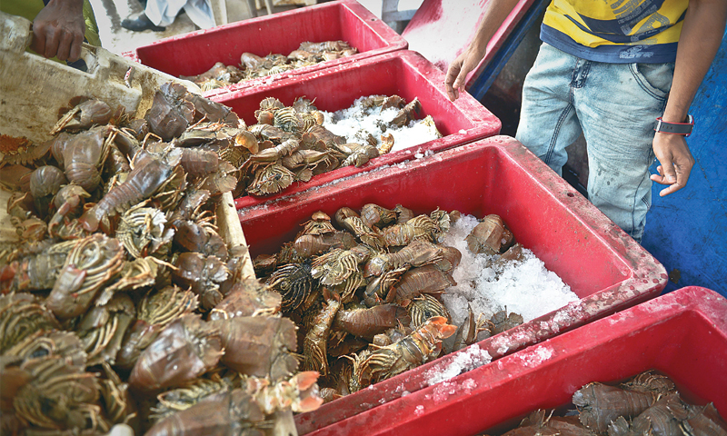
Figure 1.6 Lobster Catch, Lasbela Fisheries
[1] Table 17 Number of Commercial Poultry Farms and Number of Birds by Size of Flock
Irrigation Network; Lasbela district
The major sources of irrigation are tube wells, and canals. Lasbela canals off-taking from the Hub Dam Reservoir irrigate most of the lands of Lasbela district.
The following table shows the mode of irrigation and area being irrigated by the mode (Balochistan Development Statistics 2018-19):
| Total Irrigated Area | 37,548 HA | Government Canals | 415 HA |
| Private Canals | – HA | Wells | – HA |
| Tube Wells | 37,133 HA | Karez/Spring/Others | – HA |
Table 1.11 Lasbela Irrigation Statistics
In order to improve the irrigation system, the Government of Balochistan is building small dams all over Balochistan. The dams being built in Lasbela district are Kukar Dam on Kukar Dhora, Windar Storage Dam on River Windar, and Hingol Dam on River Hingol. The Uthandaro Dam on Uthandaro Dhora has recently been completed. There are no karezes in the district.
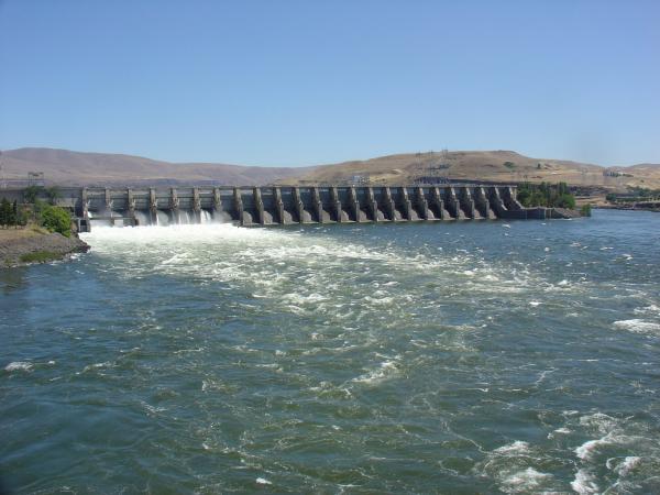
Figure 1.18 Hub Dam
Mining; Lasbela district
Major mineral deposits found in the district include lead, zinc, manganese, chromite, serpentine, dimension stone,[1] red ocher, iron ore, and barite. The potential for mining of the dimension stones encouraged the Government of Balochistan to establish Marble City at Hub, where the blocks of dimension stones are processed for cutting and polishing to an extent. Dimension stone of good quality is being mined at Kanraj, Loai, Shah Noorani, and Durraje, among other locations. Large deposits of fossil-ferrous and non-fossil-ferrous dimension stone of different colors are exposed on the ground surface and are being mined through quarries.
Oil and gas exploration is being carried out in the district.
Manufacturing/ Industry; Lasbela district
The Lasbela Industrial Estate Development Authority (LIEDA) was established in 1982 and this attracted investors to invest in the Hub Industrial Estate (HIE). At present, there are 5 Industrial Estates in the district: Hub Industrial & Trading Estate (HITE), Marble City Gaddani (MCG), Windar Industrial and Trading Estate (WITE), Special Industrial Zone Windar (SIZ Windar) and Uthal Industrial Estate Phase I and II (UIE).
These Industrial Estates[2] house the following industries:
| Industry | No. of Units | Industry | No. of Units |
| Food Products & Beverages | 16 | Textile Manufacture | 24 |
| Steel | 13 | Paper & Packaging | 06 |
| Cable | 04 | Chemicals & Pharmaceuticals | 22 |
| Plastic & PVC | 09 | Poly propylene Bags | 06 |
| Others | 10 | Marble/Pipe/Cement | 06 |
| Engineering | 18 | Motor Cycles | 08 |
| Woodworks | 08 | Leather/Rubber | 03 |
| TV | 02 | Power Generation | 02 |
| Recording | 01 | Oil Refinery | 01 |
| Fabrication | 01 | Bob Film | 01 |
Table 1.9 Lasbela Industries
In addition, the Ship Breaking Industry in Gadani is the third largest ship breaking industry in the world. The yard consists of 132 ship breaking plots[3] located across a 10 km long beachfront at Gadani.
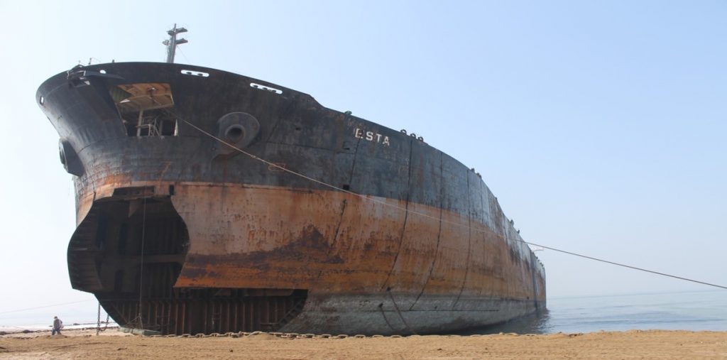
Figure 1.7 A Ship ready for Breaking at Gaddani, Lasbela

Figure 1.8 Hub Industrial Estate, Lasbela
Handicrafts; Lasbela disrict
Common handicrafts of the district are Balochi embroidery done by women, and artefacts made of stone. Pathar (Stone) Colony is a colony where most of the stone work is done. Other handicrafts include carpets, handmade furniture, and goods made of
[1] Dimension stones are natural rocks quarried for the purpose of obtaining blocks or slabs cut to size; these can be marble, granite, limestone, or sandstone among others.
[2] District Development Plan 2011, by GoB and UNICEF
[3] Ship Breaking & Recycling Industries in Pakistan and Bangladesh, A report for World Bank in 2009 by Maria Sarraf and Milen Dyoulgerov
Economic Infrastructure; Lasbela District
District Lasbela has comparatively better road linkages to other parts of the province than many other districts of Balochistan. The district has National Highways, as well as Provincial and District Roads. A major road link is the National Highway N-25 (RCD Highway), which links Karachi with Hub, Uthal, Khuzdar, Kalat, and Quetta. All parts of the district are accessible by roads.
Road Statistics; Lasbela district
According to the Balochistan Development Statistics 2018-19, the road statistics of the district are as follows:
| Total Roads | 2,594.0 km |
| High Type Roads/Black Topped | 1,362.0 km |
| Low Type Roads/Shingle | 1,232.0 km |
Table 1.10 Lasbela Road Statistics
The National Highway N-25 or the RCD Highway passes through Bela town, and is the lifeline of the district. Other important roads of the district are:
- Makran Coastal Highway N-10; connects Highway N-25 with Gwadar and passes through Hingol National Park
- Bela–N-25 Link Road
- Khurkhera-Kunraj Road
- Road connecting Uthal with Bela
Dureji is linked to Hub Chauki and Karachi. Gadani, Sonmiani, Kanraj, and Lakhra are linked with the Karachi-Quetta National Highway N-25.
Rail and Airways; Lasbela district
There is no railway network or airport in the district. The nearest railway station and airport is the Karachi Railway Station and Quaid-e-Azam International Airport.
Radio and Television; Lasbela district
Lasbela has no radio or TV stations or even TV boosters; however, every second house in the urban areas has a TV set with satellite dish. In the rural areas, upper, and middle class households possess television sets.
Telecommunications; Lasbela district
In Lasbela district, Pakistan Telecommunication Corporation (PTC) has established 05 telephone exchanges providing 1,639 landlines, 569 wireless phone connections, and 1,539 broadband connections (Balochistan Development Statistics 2018-19). In addition, all major cellular services are available in the district.
Post Offices/ Courier Services; Lasbela district
According to Balochistan Development Statistics 2018-19, there are 11 post offices in the district. Most of the courier service providers provide services in the district.
Banking/ Financial Institutions; Lasbela district
The following banks all have their branches in the district[1]:
- Muslim Commercial Bank Ltd.
- Habib Bank Ltd.
- Bank Al-Habib Ltd.
- AG Zurich Bank Ltd.
- Meezan Bank Ltd.
- National Bank of Pakistan
- Soneri Bank Ltd.
- Burg Bank Ltd.
- Habib Metropolitan Bank Ltd.
- United Bank Ltd.
- Zarai Taraqiati Bank Ltd.
In all there are 23 branches of various conventional banks and 07 branches of different Islamic banks in the District.
Electricity and Gas; Lasbela district
In Lasbela district, Karachi Electric (KE) looks after the supply of electricity. The Hub Power Company supplies power/electricity to the industrial areas.
There is no natural gas pipeline for domestic use in the district. Gas is supplied via pipelines[2] to the industrial areas.
[1] List of Reporting Bank Branches 2019 by State bank of Pakistan.
[2] Lasbela District Development Plan 2011 by GoB and UNICEF
Educational Institutions; Lasbela district
The following table shows the number of primary, middle, secondary, and mosque schools in the district as per Balochistan Development Statistics 2018-19:
| Institution | Boys/Girls | Institution | Boys/Girls |
| Primary Schools | 378/130 | Middle Schools | 36/25 |
| High Schools | 29/06 | Community Schools | 26 |
| Higher Secondary | 01/02 | Degree Colleges | 02/- |
| Universities[1] | 01 | Mosque Schools[2] | – |
| Vocational training schools[3] | 01 | Private schools | 06 |
Table 1.12 Lasbela Educational Institutes

Figure 1.19 Lasbela University of Agriculture, Water & Marine Sciences
Healthcare Facilities; Lasbela district
The following table shows the Government Health Care Institutions in Lasbela district as per Balochistan Development Statistics 2018-19:
| Institution | No./beds | Institution | No./beds |
| Teaching Hospitals | – | Hospitals | 03/92 |
| Rural Health Centers | 04/40 | Basic Health Units | 42/- |
| Dispensaries | 26/- | Mother Child Health Centers | 04/- |
| TB/Leprosy Clinics etc. | 01/- | Private Hospitals | 01/08 |
| Private Dispensaries | 01/- |
Table 1.13 Lasbela Health Institutes
Policing; Lasbela district
For the purpose of administration, the district is divided into two areas: “A” and “B”. The urban area of Lasbela comes under “A” area and the rest of the area of the district falls in “B” area. “A” area is controlled by a regular police force, headed by the Deputy Superintendent of Police (DSP). This DSP is assisted by a Station House Officer (SHO), Inspector Police, and other staff. The “B” area is controlled by levies force. Levies are a conventional force to help maintain law and order. In levies, men of different tribes are employed. The levies force comes under the direct control of the Deputy Commissioner (DC). Generally, the levies force is well equipped to deal with the law and order situation in the district.
Policing of the district[4] is controlled by the Regional Police Officer (RPO) Kalat, who has 3 SubDivisional Police Officers (SDPO), 1 each at Hub, Kanraj, and Uthal. The SDPO at Hub controls 04[5] police stations, the SDPO at Kanraj has 1 police station and the SDPO at Uthal has 2 police stations. There are a total of 07 police stations in the district.
[1] University of, Lasbela (LUAWMS)
[2] included in primary schools
[3] National Vocational & Technical Training, Commission Lasbela University Uthal
[4] Balochistan Police Official Website
[5] Table no. 19.7 (a) Number of Police Stations by Division/District 2019 by Federal Bureau of Statistics.
Environment and Biodiversity; Lasbela District
Lasbela faces a range of environmental problems due to pollution. Two major sources of pollution of the water bodies are the Gadani ship-wrecking industry and the Gadani Industrial Estate. The Industrial Estate located at Hub is the largest industrial establishment in Balochistan. The gaseous emissions and effluents from both these large industrial establishments have badly affected the local environment and have caused considerable pollution of water bodies as well as the sea, causing damage to local fisheries and the fishing industry.
Flora and Fauna; Lasbela district
Flora; Lasbela district
Major tree species found in the district are peelu (Salvadora oleoides), kandi (Prosopis cineraria), ber (Zizyphus nummularia), date palm (Phoenix dactylifera), gaz (Tamarix sp.), kikar (Acacia jacquemontii), and kotor (Cadabaferinosa). The Mangrove species are Avicenia marina, Rhizophora mucronata, and Ceriop stagal. Main shrubs are Euphorbia cauduicifolia, Haloxylon sp., Calligonum polygonoides, gugul (Commiphoramukal), Merin (Heliotropium sp.), gujo (Aervajavanica), aak (Callotropis procera), Alhaji camelerom and mazri (Nannorr hopsritchieana). The ground cover consists of grasses like Eliosine sp., Lasiurus sp., Chrysopogon sp., Aristidasp and Cymbopogon sp.
The main vegetation zones are:
- Hills: Tree and bush species are ber (Ziziphus nummularia), kikar (Acacia jaquemontii), gum Arabic/khumbat (Acacia Senegal), pilu (Salvadora oleoide), gugul (Commiphora mukal) and mazri palm/dwarf palm (Nannorrhops ritchieana)
- Plains: Main species in the plains are kandi (Prosopis cineraria), babul (Acacia nilotica), pilu (Salvadora oleoides) and ber (Ziziphus nummularia)
- River and stream beds: Naturally occurring main species on alluvium patches along the rivers include salt cedar (Tamarix spp.), kandi (Prosopis cineraria), and the invasive alien species mesquite (Prosopis juliflora)
- Sand dunes on the coastal front: On the dry sandy saline shore, the common grass is Urochondra setulosa. Other grasses include Sporobolus heterophyllus, Dactyloctenium aristatum, and Ochthochloa compressa. Scrubs in this area include Heliotropium crispum, Haloxylon sp., Tamarix sp., Suaeda sp. and Salsola sp. (common names of these grasses are not known)
- Inter-tidal swamps, islands and lagoons: The Mangrove species are timmer (Avicenia marina), kumr (Rhizophoras mucronata), and kain (Ceriops tagal)
The rangeland type in the district is classified as Southern Balochistan Ranges. It has species like leafless milk hedge or thor (Euphorbia caducifolia), ivy (Haloxylon sp.), phog (Calligonum polygonoides), heliotrope or gorakh (Heliotropium sp.), snow bush or kapok bush (Aerva javanica), camel thorn or jawain (Alhagi camelorom), mazri palm or dwarf palm (Nannorrhops ritchieana), goose grass (Eleusine sp.), sewan grass (Lasiurus sp.), (Chrysopogon sp.), Aristidasp, and Cymbopogon sp.
Fauna; Lasbela district
Mammals found in the district include caracal, honey badger, chinkara gazelle, ibex, urial, wolf, Bengal fox, Asiatic jackal, striped hyena, cape hare, and porcupine.
The avifauna include wheatears, common babblers, larks, sand grouse, partridges, houbara bustard, shrikes, buntings, bee-eaters, hoopoes, pigeons, and doves, white-eared bulbuls, brown-headed ravens, owls, and birds of prey (eagles, vultures, hawks, buzzards, falcons). The major birds found along the coastline, lagoons, and estuaries are seagulls, terns, pelicans, flamingos, herons, egrets, plovers, lapwings, stints, sandpipers, godwits, shanks, coots, curlews, kingfishers, and osprey.
The coastal areas are a refuge for green and olive ridley turtles. In the Hub and Hingol rivers, there is a good population of marsh crocodiles. Spiny-tail lizard, black rock agama, and monitor lizard are common lizards found in the district. Among snakes, the district hosts the common krait, 2 types of cobras (the common cobra, and the brown or oxus cobra) and vipers like saw-scaled sand viper and horned viper.
Protected Wildlife Areas and Wildlife; Lasbela District
Some forested areas have been designated Wildlife Sanctuaries and Game Reserves; these are:
- Khurkhera Wildlife Sanctuary
- Dureji Game Reserve
- Part of Hingol National Park
- Hub Dam Reservoir (Ramsar List of Protected Areas)
- Miani Hor (Ramsar site)
- Siranda Lake, Uthal
These provide protection/sanctuary to the wildlife of the district, specifically endangered mammals like the chinkara, urial, and ibex. At the Hub Dam Reservoir site, migratory birds like little and great grebes, black necked grebe, dalmation pelican (endangered), white pelican, a variety of cormorants, a variety of egrets, a variety of terns (endangered) and partridges, among others, are given protection.
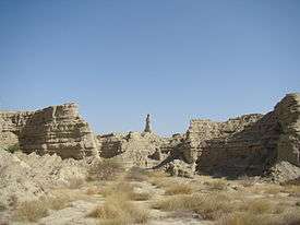
Figure 1.9 Princess of Hope, Hingol National Park