Share now
Map of Balochistan

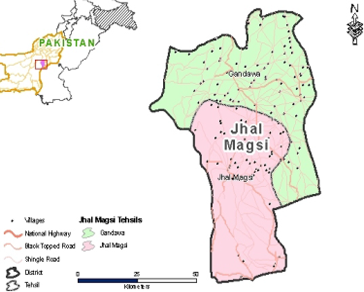
Map of Jhal Magsi District
Balochistan Districts
- Quetta District Profile
- Awaran district Profile
- Barkhan District Profile
- Bolan District Profile
- Chagai District Profile
- Dera Bugti District Profile
- Gwadar District Profile
- Harnai District Profile
- Jaffarabad District Profile
- Jhal Magsi District Profile
- Kalat District Profile
- Kech District Profile
- Kharan District Profile
- Khuzdar District Profile
- Killa Abdullah District Profile
- Killa Saifullah District Profile
- Kohlu District Profile
- Lasbela District Profile
- Loralai District Profile
- Mastung District Profile
- Musakhel District Profile
- Nasirabad District Profile
- Nushki District Profile
- Panjgur District Profile
- Pishin District Profile
- Sherani District Profile
- Sibi District Profile
- Washuk District Profile
- Zhob District Profile
- Ziarat District Profile
Also visit: Sindh, Punjab, Khyber Pakhtunkhwa
Introduction/Geographical Location Jhal Magsi District
Jhal Magsi district is located between 67° 09′ 34″ and 67° 48′ 13″ east longitudes and 27° 53′ 34″ and 28° 50′ 50″ north latitudes. The district is bordered by Bolan district on the north, by Jaffarabad and Nasirabad districts on the east, by Larkana district of Sindh province on the south, and by Khuzdar district on the west. Up until 1993 it was part of Kachhi district.
Jhal Magsi District at a Glance
| Name of District | Jhal Magsi District | |
| District Headquarters | Gandawah Town | |
| Population[1] | 149,225 persons | |
| Area[2] | 3,615 km2 | |
| Population Density [3] | 41.3 persons/ km2 | |
| Growth Rate[4] | 1.7% | |
| Male Population[5] | 51.5% | |
| Female Population[6] | 48.5% | |
| Urban Population[7] | 5.2% | |
| Tehsils/ Talukas | 02 Tehsils and 01 sub-Tehsil:
|
|
| Main Towns | Jhal Magsi, Gandawah, Mirpur, Kot Magsi, Abad, Khanpur Bhaltoor, Kotra, Altaz Khan, and Bhootani | |
| Literacy Rate[8] | 25% | |
| Male Literacy Rate[9] | 38% | |
| Female Literacy Rate[10] | 11% | |
| Major Economic Activity[11] | Agriculture with its allied Livestock Breeding and Fishing | 79.9% |
| Elementary Occupations | 15.2% | |
| Clerks | 1.9% | |
| Others | 3% | |
| Main Crops | Wheat, barley, rapeseed & mustard, canola, sunflower, jowar, sesanum, moong, maash, moath, guar seed, cotton, tobacco, and sugarcane | |
| Major Fruits | Mangoes, citrus, guavas, dates, watermelon, ber, and mulberry | |
| Major Vegetables | Onion, tomatoes, okra, tinda, spinach, cabbage, carrots, bitter gourd, bottle gourd, pumpkin, cauliflower, brinjal, and coriander | |
| Forest (Area)[12] | 32,518 HA[13] | |
| Total Black Topped Roads[14] | 1,034.0 km | |
| Shingle Roads[15] | 99.0 km | |
| Electricity[16] | Quetta Electric Supply Company (QESCO) looks after supply and transmission of electricity | |
| No. of Tel. Exchanges[17] | 02 Telephone Exchanges providing 767 landlines, 467 wireless phones, and 235 broadband connections. | |
| Industrial Zones[18] | No Industrial Zones or Estates in the district | |
| Major Industry[19] | None | |
| Household Size[20] | 6.8 persons per house | |
| Houses with Piped Water[21] | 9.2% | |
| Houses with Electricity[22] | 32% | |
Table 1.1 Jhal Magsi District at a Glance
[1] 2017 Census
[2] 1998 Census
[3] 2017 Census
[4] 2017 Census
[5] 2017 Census
[6] 2017 Census
[7] 2017 Census
[8] Pakistan Social & Living Measurement Survey 2014-15 (PSLM); Latest available.
[9] PSLM
[10] PSLM
[11] 1998 Census; 2017 Census Data has not been made public yet.
[12] Balochistan Development Statistics 2018-19
[13] Land Utilization Statistics reports zero area under forests
[14] Balochistan Development Statistics 2018-19
[15] Balochistan Development Statistics 2018-19
[16] Balochistan Development Statistics 2018-19
[17] Balochistan Development Statistics 2018-19
[18] Jhal Magsi district Profile 2011, P&D Department GoB
[19] Jhal Magsi district Profile 2011, P&D Department GoB
[20] 1998 Census; 2017 Census Data has not been made public yet.
[21] 1998 Census; 2017 Census Data has not been made public yet.
[22] 1998 Census; 2017 Census Data has not been made public yet.
Brief History – Governmental Structure – Administrative Divisions – Heritage Sites/ Tourist Attractions
Brief History Jhal Magsi District
The district is named after Jhal Magsi, the headquarters of the Magsi tribe, which is a major tribe within the district. The district was part of the Kachhi Plains which were an administrative division of the Kalat State of Balochistan. The history of the Kachhi area (Jhal Magsi area) of Balochistan is intimately connected with that of Sindh.
The Jhal Magsi district has 2 tehsils: Gandawah and Jhal Magsi, and both these tehsils have different histories recounted below.
History of Gandawah Tehsil
Gandawah town of the district is located in the Kachhi Plains and is an ancient town. It was originally known as Kandabil; in the 7th century AD, Rai Chach[1] had his headquarters at Kandabil (located east of Kalat). The Arabs reached Kandabil in 644 AD and changed the name to Gangaaba which later became Gandawah. The Arabs did not stay in the region and the area remained under the rule of the Chach Dynasty.
After the conquest of Sindh by the Arabs in 712 AD, the Kachhi area remained under Arab rule till the end of the 10th century AD, when the Kachhi Plains, including Kandabil/Gandawah, passed into the hands of the Soomras (also spelled Soomras; 1024-1351) and then the Sammas (1351-1524 AD) of Sindh.
The Baloch entered the area in the 15th century and the area became the battleground between their two leaders: the Great Mir Chakar Khan Rind and Gwahram Lashari[2]. The Rinds and allied clans arrived in the plains of Sibi through the Bolan Pass, while the Lasharis and their allied clans passed through the Mula Pass to spread into the plains of Kachhi-Gandawah country. There, the Rinds, led by Mir Chakar Khan, and the Lasharis, led by Mir Gwahram Lashari, quarreled leading to a dispute which resulted in a 30 year war. This war became the main theme of Baloch classical poetry. The Lasharis received help from the Samma ruler of Sindh, Jam Nizam-ud-din (1462-1568), and the Rinds were helped by the Arghuns of Afghanistan. The 30 year war sapped the energies of both tribes, and thus, the Arghuns were able to extend their power into the plains of Sibi and then to Sindh. Ultimately, under pressure from the neighboring rulers, the Rinds and Lasharis disengaged from the war, with the Rinds withdrawing to the Multan region, and the Lasharis toward Thatta.
Gandawah town became part of Kalat State at its formation in 1666 as part of the Kachhi Plains. Gandawah was the winter headquarters of the Khans, and remained the headquarters of the Kachhi subdivision of Kalat State.
The name of Kandabil/Gangaaba was officially changed to Gandawah during the British Colonial Period.
History of Jhal Magsi Tehsil
The Magsi branch of the Lasharis settled in the Jhal area of Kachhi which was then named Jhal Magsi. The word Jhal means a waterway; hence, the term Jhal Magsi literally means the “waterway of the Magsis.” Jhal Magsi is a purely Baloch area, and was part of the Kalat State and Kachhi province during the Colonial Period. The Magsi tribe enjoyed a great deal of autonomy during the Kalat Khanate; Kalat, in turn, was one of the native Princely States that had considerable tribal autonomy during the Colonial Period.
After Independence from the British in 1947, Gandawah was one of the Tehsil headquarters of Kalat district. In 1965, Kachhi was notified as a separate district and Gandawah became a Tehsil of Kachhi district.
The Jhal Magsi area was upgraded to a sub-Tehsil level in 1958 and made a part of Gandawah Tehsil. Jhal Magsi was made a subdivision in 1989.
On 31 December, 1991, Kachhi district was bifurcated into Kachhi district and Bolan district, and on 23 May, 1992, Kachhi district was renamed Jhal Magsi district with Gandawah as its headquarters.
The Jhal Magsi district is rich in archeological sites and historical monuments. Archeological sites are located near Khanpur Bahltoor and Kotra (called Pingar Mari) named after Dalorai Damb, a former Hindu king. Also important are Damb Hazoor Bux, the Tomb of Moti Ghoram (which is near old Khanpur), Tomb Altaz Khan near Panj Monah, Tomb Mian Sahib, and Tomb Bhootani.[3]
Many important saints (Pirs) are buried in the district. Among them are Muhammad Ayub Shah Bukhari (Gandawah), Sain Rakhil Shah and Sain Chizal Shah (Fatahpur) and Pir Chattal Shah (near Kotra). Their followers visit these places frequently. Pir Lakha is a famous shrine near Jhal Magsi, with hot springs called Aab-i-shifa, bathing in which cures many skin diseases. Therefore, visitors regularly arrive in Pir Lakha from far flung areas.[4]
Governmental Structure Jhal Magsi District
At the Federal level, Jhal Magsi district is allocated a set number of representatives in both the National Assembly and the Provincial Assembly:
- Number of seats in the National Assembly[5] 1
- Number of seats in the Provincial Assembly 1
Under the Local Government Act 2010, Amended in 2011, Jhal Magsi district has 1 District Council with 12 Union Councils. It has 1 Municipal Committee as follows:
- Gandawah
Each Union Council is represented by 1 member in the District Council. In addition, there is special representation of women (33%) and of workers and peasants (5% each).
Administrative Divisions Jhal Magsi District
Jhal Magsi district has a total area of 3,615 km2 and is divided into 2 tehsils and 13 Union Councils as follows:
| Jhal Magsi Tehsil | 09 Union Councils |
| Gandawah Tehsil | 03 union Councils. |
| Mirpur Sub-Tehsil | 01 Union Council |
Table 1.2 Jhal Magsi Administrative Divisions
Historical/Heritage Sites, Tourism/Picnic Spots Jhal Magsi District
There are no historical/heritage or wildlife protected sites in the district, but there are many archeological sites and historical monuments[1] which need to be protected by Pakistan laws. These are near Khanpur Bahltoor and Kotra and are called Pingar Mari. Other archeological sites are:
- Dalorai Damb, named after a former Hindu king
- Damb Hazoor Bux
- Tomb of Moti Ghoram, near old Khanpur
- Tomb Altaz Khan, Panj Monah
- Tomb Mian Sahib
- Tomb Bhootani
Some important shrines of saints (Pirs) are:
- Muhammad Ayub Shah Bukhari, Gandawah
- Sain Rakhil Shah, Fatahpur
- Sain Chizal Shah, Fatahpur
- Pir Chattal Shah, Kotra
- Pir Lakha, Kotra
Since the district’s history is closely linked to the history of Sindh, tombs of various Kalhora kings are also found in the district in various areas.

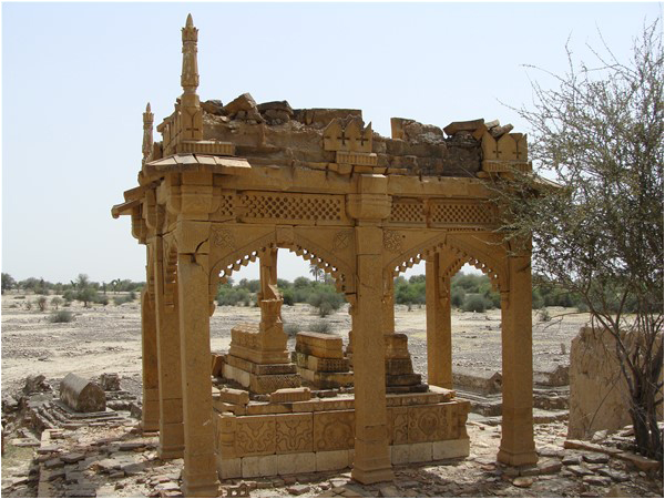
Figure 1.5 Tomb of a Kalhora King, Jhal Magsi
Figure 1.6 Pir Chattal Noorani, Spring Jhal Magsi
In 2005, a Jhal Magsi Desert Jeep Safari Rally was initiated. This event has since become an annual one, and attracts adventurers, while promoting tourism in the area.
There is a small oasis near Mula Chotok which has several water pools filled with clear water from waterfalls created by rivers flowing from nearby mountains.
[1] Jhal Magsi District Profile 2011, by P&D Department GoB
[1] Rai Chach (610-671 AD) was a Brahmin who reigned as King of Sindh in the mid-7th century AD, a former Chamberlain and Secretary to the King Rai Sahasi II. Chach ascended to the throne by marrying the king’s widow.
[2]The Magsi Tribe are a branch of the Lashari Tribe
[3] Jhal Magsi District Profile 2011 by GoB
[4] Jhal Magsi District Profile 2011 by GoB
[5] This seat is shared by Panjgur district
Topography Jhal Magsi district
Jhal Magsi district is mostly a Plain Area (almost 80%) with mountainous ranges in the west. The district is located 40 to 1,544 m above mean sea level and has an imperceptible slope from north to south.
Only 20% of the district is mountainous. These ranges are a part of Kirthar Mountain Range, which is one of the famous mountain ranges in Balochistan. The height of the hills varies from 300 to 1,200 m in general.
Rivers and Streams Jhal Magsi district
The main rivers are Bolan, Badra, Bagh, Sukleji, Nari, Sharkal, Dhoorir, Pir Chattal, and Mula which irrigate several thousand acres of land. The Mula River rises in the Kirthar Range and, after passing near the Mula Pass, enters Jhal Magsi, where the bed extends over a large area and is cut into a large number of channels. Other seasonal nalas (streams) are Narjo, Hingan, Kashok, and Sain. The district receives hill torrents from the Marri Bugti Hills and the Kirthar Range.
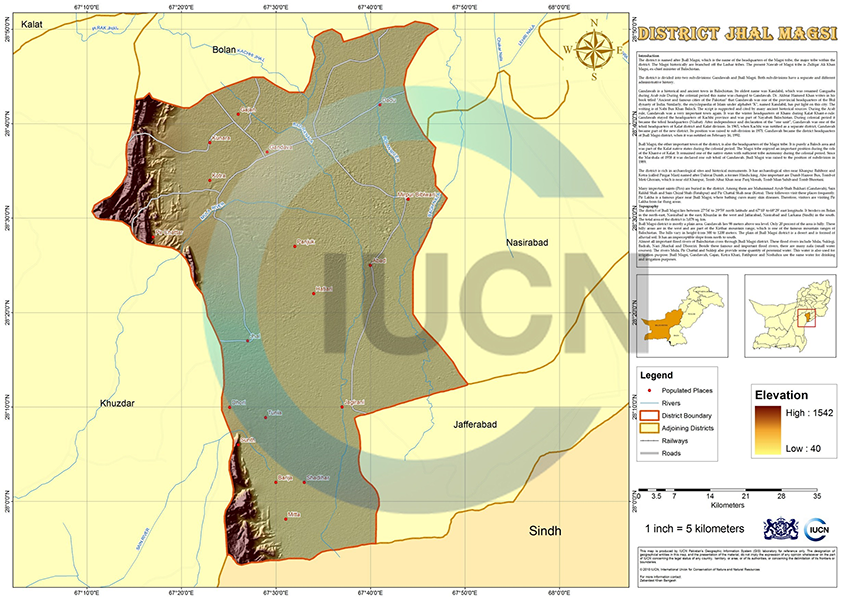
Figure 1.3 IUCN GIS Map Jhal Magsi District
Forests in Jhal Magsi district
A total of 80,353 Acres of land is under scrub forests in the district. The main species of trees are peelu (Salvadora oleoides), maru (Maerua crassifolia), karir (Capparis decidua) and kikri (Acacia jacquemontii).
Gahela, near Ghajan, is the largest forest in the district.
Soils of Jhal Magsi district
The soils of Jhal Magsi district are alluvial in nature.
Climate Jhal Magsi district
The climate of the district is extremely hot and dry in the summer. The summer season starts from April and lasts till October. June is the hottest month, with mean maximum and minimum temperatures of about 44 °C and 29 °C respectively. From November to the middle of March, the climatic conditions are pleasant. January is the coldest month and the mean maximum and minimum temperatures during this month are 23 °C and 8 °C.
Rainfall is scanty and varies from place to place. Average annual rainfall in the district is 110 mm.
Seismic Activity Jhal Magsi district
The district belongs to Zone 3 of the Seismic Zone Map of Pakistan, which means moderate to severe damage due to earthquakes.
Population Jhal Magsi district
The following table shows the population of Jhal Magsi as per 2017 Census:
| Tehsil/ Taluka | Area
km2 |
Population | Male% | Female% | Urban % | Growth Rate % | ||||||
| Jhal Magsi District | 3,615 | 149,225 | 51.5 | 48.5 | 5.2 | 1.62 | ||||||
| Gandawah Tehsil | –[1] | 51,206 | ||||||||||
| Jhal Magsi Tehsil | –[2] | 88,575 | ||||||||||
| Mirpur Sub-Tehsil | –[3] | 9,444 | ||||||||||
Table 1.3 Jhal Magsi Population Statistics
Religions Jhal Magsi district[4]
| Muslims | 98.7% |
| Christians | Negligible % |
| Hindus | 1.0% |
| Ahmadis | 0.1% |
| Scheduled Castes | 0.1% |
| Others | 0.1% |
Table 1.4 Jhal Magsi Religions
Languages Jhal Magsi district[5]
| Urdu | 0.1% |
| Punjabi | 0.1% |
| Sindhi | 21.1% |
| Pushto | 0.1% |
| Balochi | 68.8% |
| Seraiki | 8.2% |
| Others[6] | 1.6% |
Table 1.5 Jhal Magsi Languages
[1] Data not available.
[2] Data not available.
[3] Data not available.
[4] 1998 Census; 2017 Census Data has not been made public yet.
[5] 1998 Census; 2017 Census Data has not been made public yet.
[6] includes Brahui language
Economic Activity – Economic Infrastructure
Economic Activity Jhal Magsi district
Main occupations in the district include:
- Agriculture with its allied Livestock Breeding and Fishing (79.9%)
- Elementary Occupations (15.2%)
- Clerks (1.9%)
- Other occupations (include crafts and construction) (3.0%)
Land Use Jhal Magsi district
The following table shows the main land use statistics of the district as per Balochistan Development Statistics 2018-19:
| Total Area | 361,500 HA | Reported Area | 333,251 HA |
| Total Cultivated Area | 131,049 HA | Net Sown | 66,425 HA |
| Current Fallow | 64,624 HA | Total Uncultivated Area | 202,202 HA |
| Culturable Waste | 98,208 HA | Forest Area | – HA |
Table 1.6 Jhal Magsi Land Use Statistics
Agriculture Jhal Magsi district
The district falls under the Tropical Agro-Ecological Zone and Western Dry Mountain Agro-Ecological Zone of Pakistan. The crops include wheat, barley, rapeseed & mustard, canola, sunflower, jowar, sesanum, moong, maash, moath, guar seed, cotton, tobacco, and sugarcane.
Fruits include mangoes, citrus, guavas, dates, watermelon, ber, and mulberry. Onion, tomatoes, okra, tinda, spinach, cabbage, carrots, bitter gourd, bottle gourd, pumpkin, cauliflower, brinjal, and coriander are the vegetable produce of the district.
Livestock Breeding Jhal Magsi district
Livestock breeding is the second most important sector of the economy. It is the main source of income for nomadic families. The following table shows the position of the Livestock Population in the district according to the 2006 Census of Livestock (qtd. in Balochistan Development Statistics 2018-19):
| Cattle | 78,294 Heads | Buffalos | 4,275 Heads | Sheep | 61,295 Heads |
| Goats | 298,687 Heads | Camels | 3,898 Heads | Horses | 3,613 Heads |
| Mules | – Heads | Asses | 137,003 Heads |
Table 1.7 Jhal Magsi Livestock Statistics
Bhagnari cattle, berberi goat, Balochi sheep, and aseel chicken are the indigenous livestock breeds of the district.
Poultry Farms Jhal Magsi district
Data on the number of poultry farms in the district is not available. In rural areas of the district, women raise poultry for meat and eggs. Government poultry farm do not exist; however, small and medium scale private/commercial poultry farms of broiler and layer breeds exist in the district (Jhal Magsi District Profile 2011, by the Planning and Development Department, Government of Balochistan in collaboration with UNICEF).
Fishing in Jhal Magsi district
Fish are found in the Mula River and its tributaries; this fish is consumed locally.
Bee Keeping/ Apiculture Jhal Magsi district
Due to the arid nature of the landscape, scanty rainfall, and lack of vegetation, bee keeping is almost negligible in the district as a viable economic activity.
Irrigation network Jhal Magsi district
The major sources of irrigation in the district are canals. Various streams like Sukleji, Pir Chattal, and the Sharkal Nala ultimately join and form one stream, the waters of which are then used for irrigation purposes. In addition, Mir Saifullah Magsi Canal irrigates the lands of Kot Magsi. Moola Channel, Escope, Pat Magsi, Laibo, Miskan, Zareenabad, Baighari, Jodha, Dhoori, Malwani, Karam Khan Khosa, Missri Khosa, Sippy, Ahmedabad, Beera, Gharr, Abad Distry, Abad Channel, Badra Nalla, and Sindur Distry Channel of Sikandar also provide irrigation waters.
The following table shows the mode of irrigation and area being irrigated by the mode (Balochistan Development Statistics 2018-19):
| Total Irrigated Area | 70,255 HA | Government Canals | – HA |
| Private Canals | 44,255 HA | Wells | – HA |
| Tube Wells | 21,009 HA | Karez/Springs/Others | 4,991 HA |
Table 1.9 Jhal Magsi Irrigation Statistics
According to the Jhal Magsi District Profile 2011, by the Planning and Development Department, Government of Balochistan in collaboration with UNICEF, 56% of land in the district is irrigated by canals.
After the completion of Phase 3 of the Kachhi Canal Project, more areas of the district will be brought under agriculture. Naulong Dam on Mula River will store water for irrigation as well as for drinking.
Mining in Jhal Magsi district
There are no minerals being mined in the district.
Possibility of oil and gas deposits is being explored in the district.
Manufacturing/ Industry Jhal Magsi district
The industrial and manufacturing sector is almost non-existent. There are a few ice factories in the district that operate during the summer season only.
Handicrafts of Jhal Magsi district
Shoes called chaba (in the local language) are handcrafted in the district. Other handicrafts include embroidery work, and carpets.
Economic Infrastructure Jhal Magsi District
Jhal Magsi is connected with Khuzdar, Shahdadkot (Sindh), and Jacobabad (Sindh) and thus links different parts of Balochistan with Sindh. Khuzdar is linked with Shahdadkot (Sindh) through the Mula Pass and this route passes through district Jhal Magsi.
Roads Jhal Magsi district
According to the Balochistan Development Statistics 2018-19, the road statistics of the district are as follows:
| Total Roads | 1,113.0 km |
| High Type Roads/Black Topped | 1034.0 km |
| Low Type Roads/Shingle | 99.0 km |
Table 1.8 Jhal Magsi Road Statistics
Some of the important roads of the district are:
- Motorway M-8 passes through the district crossing the Sain River
- Gandawa–Kotri Pir Chhatta Road
- Gandava-Jacobabad Road
- Khuzdar-Jhal Magsi Road
Rail and Airways Jhal Magsi district
No railway and airways services exist in the district. The nearest railway station to Gandawah is at Natal and the nearest one to Jhal Magsi is Shahdadkot. The district has no airport. The nearest airport is Jacobabad airport.
Radio and Television Jhal Magsi district
Jhal Magsi has no radio or TV stations or even TV boosters. The inhabitants mostly listen to Khairpur Radio Station, which is a high powered station with a clear transmission. Its broadcasting language is Sindhi, which everyone in the district can understand and speak. The BBC radio channel is also very popular in the area. The Shikarpur television transmitter transmits its television signals to the area.
Telecommunications Jhal Magsi district
The district is connected to other parts of the country through telephone and telegraph. There are 02 telephone exchanges in Jhal Magsi district which provide 367 landlines, 467 wireless phones, and 235 broadband connections in the district (Balochistan Development Statistics 2018-19). Cellular phone companies also provide their services in the district.
Post Offices/ Courier Services Jhal Magsi district
There are 02 post offices in the district. Most of the courier companies provide services in the district (Balochistan Development Statistics 2018-19).
Banking/ Financial Institutions Jhal Magsi district
There are no bank branches in the district.
Electricity and Gas Jhal Magsi district
Quetta Electric Supply Company (QESCO) looks after the supply of electricity. After completion of the Naulong Dam on Mula River, which is slated for completion in 2018, 4.4 MW of electricity will be produced.
Educational Institutions Jhal Magsi district
The following table shows the number of primary, middle, secondary, and mosque schools in the district as per Balochistan Development Statistics 2018-19:
| Institution | Boys/Girls | Institution | Boys/Girls |
| Primary Schools | 165/81 | Middle Schools | 19/11 |
| High Schools | 13/05 | Community Schools | 21 |
| Higher Secondary | 01/01 | Degree Colleges | -/- |
| Universities | – | Mosque Schools[1] | – |
| Vocational Training Schools[2] | – | Private Schools | NA |
Table 1.10 Jhal Magsi Educational Institutes
In addition there are private schools and colleges in the District.
Healthcare Jhal Magsi district
The following table shows the Government Health Care Institutions in Jhal Magsi district as per Balochistan Development Statistics 2018-19:
| Institution | No./beds | Institution | No./beds |
| Teaching Hospitals | – | Hospitals | 01/22 |
| Rural health Centers | 03/54 | Basic Health Units | 11/- |
| Dispensaries | 16/- | Mother Child Health Centers | 02/- |
| TB/Leprosy Clinics etc. | – | Private Hospitals | -/- |
Table 1.11 Jhal Magsi Health Institutes
Policing Jhal Magsi district
For the purposes of administration, the district is divided into two areas: “A” and “B”. The town area of Jhal Magsi comes under “A” area and the rest of the area of the district falls in “B” area. “A” area is controlled by a regular police force headed by the Deputy Superintendent of Police (DSP). This DSP is assisted by a Station House Officer (SHO), Inspector Police, and other staff. The “B” area is controlled by a levies force. Levies are a conventional force that maintains law and order. In levies, men of different tribes are employed. The levies force comes under the direct control of the Deputy Commissioner (DC). Generally, the levies force is well equipped to deal with any law and order situation in the district.
The policing of Jhal Magsi district is the responsibility of the Regional Police Officer (RPO) Naseerabad. This RPO is assisted by 1 SubDivisional Police Officer (SDPO) stationed at Gandawah. In all, there are 3 police stations in the district. (19.7 (a) Number of Police Stations by Division/District, 2019; Federal Bureau of Statistics)
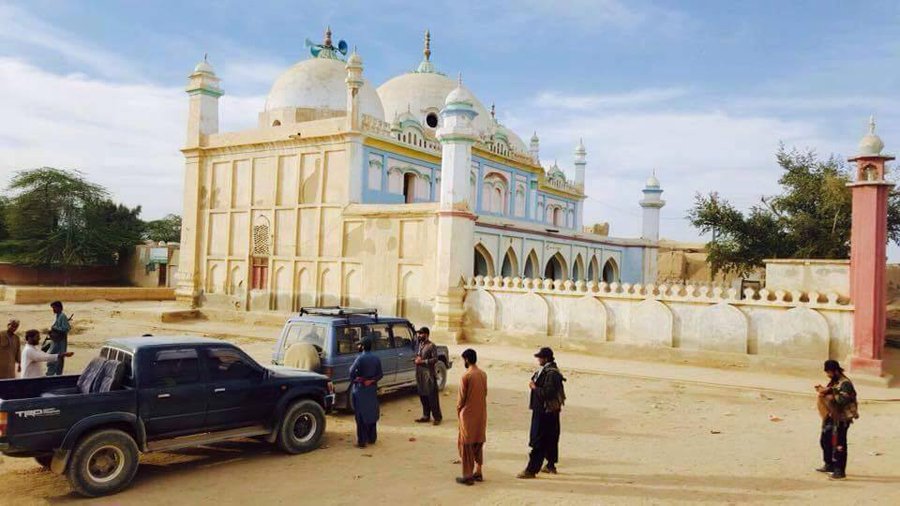
Figure 1.7 Gandawah Mosque
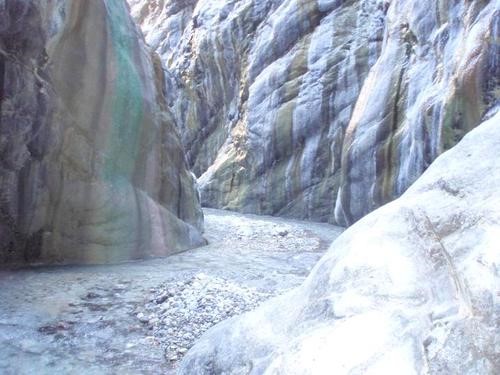
Figure 1.8 Chotok Water Fall
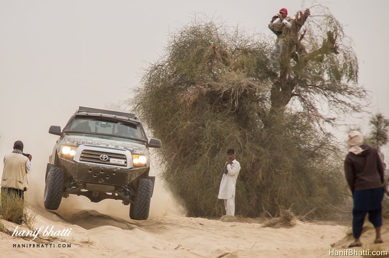
Figure 1.9 Jhal Magsi Jeep Safari
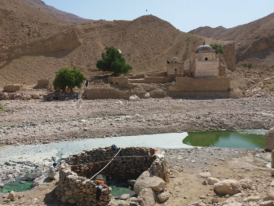
Figure 1.10 Pir Lakha Shrine
[1] included in primary schools
[2] there are plans of opening a Vocational Center at Gandawah
Environment and Biodiversity Jhal Magsi District
Environmental pollution, especially brown pollution, is almost negligible, as there is no industrial set up or heavy traffic in the district.
Flora and Fauna Jhal Magsi district
Flora Jhal Magsi district
Major tree species[1] are obusht (Juniperous excelsa polycarpos), wild ash (Fraxinus xanthoxyloides), shinay or wild pistachio (pistatia khinjjak), surai (Rosa beggeriana), injir (Ficus johannis), olive (Olea cuspidata), rorae (Ticoma undulata), gum Arabica (Accacia Senegal), and palosa (Accacia modesta). In the valleys, ghaz (Tamarix spp.) is common in streambeds.
The main shrubs and bushes are anang (Lonicera hypoleuca), chank (Cerasus rechingrii), delako (Convolvulus spinosus), gringosehchob (Spiraea brahuica), makhi (Cartagena ambigua), mateto (Salvia cabulica), malaghune (Daphne oleoides), sparea (Lonicera quinquelocularis), shenalo (Astragalus stocksii), tharkha (Artemisia maritime), Oman (Ephedra nebrodensis), wild almond (Prunus ebernea), and zralg (Berberis lyceum). Ground cover is constituted mainly by herbs like weezha (Pennisetum orientale), washta (Stipa pennata), margh (Dicenthium annulatum), sagarrai (Cymbopogon schoenanthus), and shezgi (Eremurus aurantiacus).
Vegetation zones of the district consist mainly of the following categories:
- Uphill steep rocky cliffs: These include the Zarghoon Hills (Tore Shore), where obusht (Juniperus Excelsa polycarpos) is the predominantly climax species associated with wild pistachios (Pistacia khinjjak) and wild ash (Fraxinus xanthoxyloides). Along the northern boundaries of the district, Deng Loeghar, Khaliphat, and Thore Khan Hills are major pockets that meet this category of distribution; here, olive forests monopolize the overall vegetation cover
- Foothills and Piedmont Plain: These are mostly modified for urbanization, agriculture, and other land uses. However, wherever the area is still undisturbed, it is dominated by a variety of shrubs like tharkha (Artimesia meritima), wild almonds (Prunus ebernea), makhi (Caragana ambigua), zralg (Berberis lyceum) and ghuzaira (Sophora grifithii) associated with a number of herbs and grasses. Mazri (Nannorrhops ritchiena) mixed with the palatable grass of Sargari (Cymbopogon schoenanthus), dominates the ecosystem
- Dry stream beds: Tamarix Spp. is commonly found
Fauna Jhal Magsi district
Common mammals found in the district include Suleiman markhor, wolf, common red fox, Blandford’s or Afghan fox, Asian jackal, striped hyena, Indian crested porcupine, cape hare, hedgehog, migratory hedgehog, beech or stone marten, marbled pole cat, Afghan pika, house mouse, long-tailed hamster, grey hamster, and Persian jird.
Avifauna of the district include accentor, bulbul, bunting, chat, chough, chakor partridge, eagle, falcon, lark, magpie, owl, shrike, see-see partridge, and vulture.
Reptiles include lizards, Afghan tortoise, saw-scale viper, and Levantine viper.
Protected Areas and Endangered Wildlife Jhal Magsi district
There are no protected wildlife areas in the District.
[1] Jhal Magsi District Profile 2011, by P&D Department GoB