Share now
Map of Balochistan

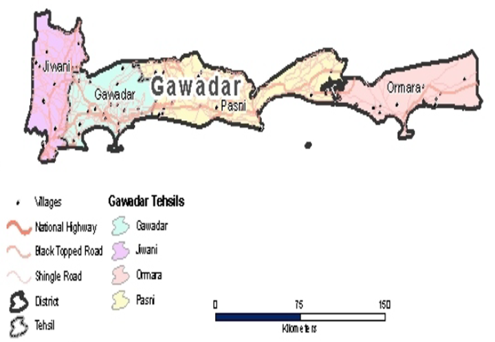
Map of Gwadar District
Balochistan Districts
- Quetta District Profile
- Awaran district Profile
- Barkhan District Profile
- Bolan District Profile
- Chagai District Profile
- Dera Bugti District Profile
- Gwadar District Profile
- Harnai District Profile
- Jaffarabad District Profile
- Jhal Magsi District Profile
- Kalat District Profile
- Kech District Profile
- Kharan District Profile
- Khuzdar District Profile
- Killa Abdullah District Profile
- Killa Saifullah District Profile
- Kohlu District Profile
- Lasbela District Profile
- Loralai District Profile
- Mastung District Profile
- Musakhel District Profile
- Nasirabad District Profile
- Nushki District Profile
- Panjgur District Profile
- Pishin District Profile
- Sherani District Profile
- Sibi District Profile
- Washuk District Profile
- Zhob District Profile
- Ziarat District Profile
Also visit: Sindh, Punjab, Khyber Pakhtunkhwa
Gwadar District Profile
Introduction/Geographical Location; Gwadar district
Gwadar district is located from 25° 01Ꞌ to 25° 45Ꞌ north latitudes and from 61° 37Ꞌ to 65° 15Ꞌ east longitudes. It is bounded on the north by Kech (Turbat) and Awaran districts, on the east by Lasbela district, on the west by Iran and on the south by the Arabian Sea.
Gwadar District at a Glance
| Name of District | Gwadar District | |
| Headquarters | Gwadar Town | |
| Population[1] | 263,514 persons | |
| Area[2] | 12,637 km2 | |
| Population Density[3] | 23.09 persons/ km2 | |
| Population Growth Rate[4] | 1.9% | |
| Male Population[5] | 53.8% | |
| Female Population[6] | 46.2% | |
| Urban Population[7] | 61.3% | |
| Tehsils/ Talukas |
04 Tehsils:
|
|
| Main Towns | Gwadar, Pasni, Jiwani, Suntsar, Ormara, Akara, Makola, Kalag, Kapper Hud, and Astola Island | |
| Literacy Rate[8] | 62% | |
| Male Literacy Rate[9] | 81% | |
| Female Literacy Rate[10] | 37% | |
| Major Economic Activity[11] | Agriculture with its allied livestock breeding and fishing | 43.8% |
| Community, Social & Personal Services | 21.6% | |
| Construction | 16.2% | |
| Wholesale, retail trade & Restaurant | 7.6% | |
| Transport, Storage & Communication | 7.4% | |
| Manufacturing | 1.7% | |
| Others | 1.8% | |
| Main Crops | Lentils (especially masoor) and fodder. None of the staple grains like wheat, maize or rice are grown in the district | |
| Major Fruits | Dates, mangoes, citrus, guava, watermelon, musk melon, bananas, papaya, coconut, loquat, and chikoo | |
| Major Vegetables | Coriander, tomatoes, okra, radish, spinach, turnip, cabbage, carrots, pumpkin, cauliflower, and brinjal | |
| Forests (Area)[12] | 31,031 HA[13] | |
| Total Black Topped Roads[14] | 408.0 km | |
| Shingle Roads[15] | 934.0 km | |
| Electricity[16] | Provided by Quetta Electric Supply Company (QESCO) | |
| No. of Tel. Exchanges[17] | 04 Telephone Exchanges with 1,102 landline connections, 399 wireless phone connections and 1,052 broadband connections | |
| Industrial Zones[18] | One Industrial Estate housing Seafood Processing Plants, Cold Storage Plants, Boat Manufacturing Sheds, and Water De-Salination Plants | |
| Major Industry[19] | 16 small, medium, and large enterprises including Seafood Processing Units, Ice Factories, Boat Making Sheds and Furniture Making as well as Mineral Water Manufacturing and Bottling Plants (2) | |
| Household Size[20] | 5.5 persons per house | |
| Houses with Piped Water Inside[21] | 48% | |
| Houses with Electricity[22] | 35% | |
Table 1.1 Gwadar District at a Glance
[1] 2017 Census
[2] 1998 Census
[3] 2017 Census
[4] 2017 Census
[5] 2017 Census
[6] 2017 Census
[7] 2017 Census
[8] Pakistan Social & Living Measurement Survey 2014-15 (PSLM); Latest available.
[9] PSLM
[10] PSLM
[11] 1998 Census; 2017 Census Data has not been made public yet.
[12] Balochistan Development Statistics, 2018-19
[13] Land Utilization Statistics report 7,511 HA under forests.
[14] Balochistan Development Statistics, 2018-19
[15] Balochistan Development Statistics, 2018-19
[16] Balochistan Development Statistics, 2018-19
[17] Balochistan Development Statistics, 2018-19
[18] Gwadar District Profile with Focus on Livelihood by South Asia Partnership, Pakistan, 2009; Latest available.
[19] Gwadar District Profile with Focus on Livelihood by South Asia Partnership, Pakistan, 2009; Latest Available.
[20] 1998 Census; 2017 Census Data has not been made public yet.
[21] 1998 Census; 2017 Census Data has not been made public yet.
[22] 1998 Census; 2017 Census Data has not been made public yet.
Brief History – Governmental Structure – Administrative Divisions – Heritage Sites/ Tourist Attractions
Brief History of Gwadar District
The word Gwadar is derived from two Balochi words: “gwad” or wind, and “dar” meaning gate, and thus the word literally means “gateway of winds.” At the time of Pakistan’s creation, the area of Gwadar, comprising Peshukan, Sur Bander, Phuleri, and Nigore, was under the political control of the Sultan of Oman, and an Agent of the Sultan, with 30 policemen known as Askaris, was responsible for its administration. Thus, Gwadar’s remote location and its unique administrative setup were responsible for its lack of infrastructural development; for example, the first primary school in Gwadar was established in 1950. In fact, social sector services and physical infrastructure were nonexistent. In 1958, the principality of Gwadar had a population of 20,000 and its total area was 777 km2. In September 1958, the Government of Pakistan purchased Gwadar from the Sultan for 8.4 million dollars and a percentage of any oil ever found on Gwadar shores.[1]
[1] Gwadar Integrated Development Vision by IUCN, and The Weekly TIME, 22 September 1958.
It is known[1] that the Makran region surrounding Gwadar was occupied by the ancient (4,000 years ago) Bronze Age people who were settled in the few oases of the region. The Makran region was later called Gedrosia, and was a part of the Achaemenid (Persian) Empire; it is believed to have been conquered by the founder of the Persian Empire, Cyrus the Great. However, the first reliable historical account for the region dates back to the time when Alexander the Great first conquered, and then crossed, this area on his way back to Macedonia in 325 BC. Greek historian Arrian has mentioned the coastline as the country of “Ichthyophagoi” or fish-eaters, a Greek name for the ancient Persian “Mahikhoran” (also fish-eaters). This Persian phrase was condensed to become Makran, a word used to refer to the region now. At the time of the Greek conquests, Nearchos, Alexander’s Admiral, sailed along this coast, and mentions places like Kalmat, Gwadar, Pishukan, and Chhabar. The Greeks ruled this area for a brief period of time before they were expelled by Chandra Gupta Maurya in 303 BC.
[1] Most information in this account has been drawn from Makran District Gazetteer and District Development Plan 2011 by GoB and UNICEF
After that, all that is known of Makran’s history is that the suzerainty of Makran gravitated sometimes to the west (Persia) and sometimes to the east (India). At one time, the Sasanian[1] power was in possession of the area; it was later conquered by Rai Chach of Sindh (610-671 AD). The area was captured by the Arabs in the 7th century, but after the decline of the Arab power in general, any records of the area disappear from authentic history until Marco Polo mentions it in about 1290 AD, calling it the most westerly part of India under an independent Chief. Local traditions state that the indigenous Baloch tribes, the Rinds, Hots and Maliks, successively held sway in the country after the Arabs; the Maliks were followed by the Buledais, who, in turn, were ousted by the Gichkis from India.
In the last quarter of the 16th century, the Portuguese found their way to India and captured several places along the Makran Coast. In 1581 they burnt “the rich and beautiful
city of Pasni and Gwadar. However, like other invaders, they did not stay here” (p. 6).[1]
[1] A Profile of District Gwadar with Focus on Livelihood by South Asia Partnership-Pakistan, 2009
[1] Persian Empire (224 BC to 651 BC)
Two regimes of local rulers, the Buledais and Gichkis, are important in Makran’s history. The Buledais gained power with the rise of the Zikri sect.[5] These rulers are said to be connected with the rulers of Muscat (Oman) and were called Buledais with reference to the valley of Buleda from which they hailed. The Buledais ruled the area for more than a century till about 1740. In the last years of their rule, they converted to Sunni Islam. The followers of the Zikri sect formed an allegiance with the Gichkis who were also Zikris by faith. The Gichkis are reputed to be of Rajput origin, and originally settled in the Gichki valley in Panjgur (India); it was from that base that they gained control of the entire region of Panjgur. Early in the 18th century, a younger branch of the Gichkis succeeded in ousting the Buledais and gaining control of Makran.
The ruler of the neighboring state of Kalat, Mir Nasir Khan I, followed an anti-Zikri faith and, in order to oust the Gichkis (Zikri faith), sought help from Ahmad Shah Abdali/Durrani of Afghanistan (1722-1772). With Durrani’s help, he was able to defeat the Gichkis, and thus added the Makran region to his Khanate. He nominated the defeated Gichki Chief, Umer Gichki, as the Governor of the area, allowing him to keep half of the revenues, with the other half awarded to the Khan. Later, Mir Nasir Khan I awarded the income of Gwadar to the Khan’s son-in-law, Ghulam Shah Jam. In 1783 the Khan of Kalat (Mir Nasir Khan I) appointed Prince Sultan Saeed Bin Ahmad, the brother of the Ruler of Muscat (capital of Oman) as his deputy at Gwadar. After the death of the Khan, Prince Saeed refused to accept the supremacy of the next ruler of Kalat (Mir Mahmood Khan I, 1794-1817) and was thus ousted by him. In retaliation, Prince Saeed raised a naval force to attack Gwadar. His attack forced Mir Khan to flee up to Sonmiani in the Lasbela area, effectively leaving Gwadar to Prince Saeed. After the death of Prince Saeed, his sons began to fight for the throne, which provided an opportunity to the British to intervene and settle their issues by signing an agreement declaring Gwadar a part of Oman. Muscat became a British Colony in 1862, and Gwadar thus became a part of the British Raj. The British laid the first telegraph line in the area connecting Iran, India, and Oman in 1868. Gwadar was a fortnightly port of call for the British India Steam Navigation Company’s steamers. The Omani enclave of Gwadar remained the territory of Oman during British rule.
After the assassination of the Sultan of Muscat in 1861, his son Saleem declared himself the ruler only to be dethroned the following year by his cousin Azzain bin Qais who ruled the sultanate till 1868.
In 1947, Balochistan areas, except Gwadar and its surroundings, joined the Balochistan States Union, as part of Makran State. The Chieftains of Makran, Lasbela, and Kharan acceded to Pakistan. A few months later, the Khan of Kalat also acceded to Pakistan, but the areas of Gwadar were not under the dominion of the Khan of Kalat. The residents of Gwadar began demanding the right to join Pakistan. In 1954, the Pakistan Government conducted a geological survey of Gwadar with the help of United States Geological Survey (USGS). The surveyor introduced Gwadar as a hammer head peninsula that was fit for a deep water port. Then, in accordance with the aspirations of the people of Gwadar, the Government of Pakistan formally requested the Sultan of Oman and Muscat for their accession of Gwadar to Pakistan. On 7 September 1958, after 4 years of negotiations, Pakistan purchased the Gwadar enclave from the Sultanate of Muscat and Oman, and Gwadar formally became part of Pakistan on 8 December 1958, after 174 years of Omani rule[6] in the region.
After becoming a part of Pakistan, Gwadar was made a subdivision of Turbat district; in 1977, it was declared a separate district by the provincial government.
Governmental Structure Gwadar district
At the Federal level, Gwadar district is allocated a set number of representatives in both the National Assembly and the Provincial Assembly:
- Number of seats in the National Assembly[7] 1
- Number of seats in the Provincial Assembly 1
Under the Local Government Act 2010, Amended in 2011, Gwadar district has 1 District Council with 18 Union Councils. It has 4 Municipal Committees as follows:
- Gwadar
- Jiwani
- Pasni
- Ormara
Each Union Council is represented by 1 member in the District Council. In addition, there is special representation of women (33%) and of workers and peasants (5% each).
Administrative Divisions Gwadar district
Gwadar district covers an area of 12,637 km² and is subdivided into 4 tehsils named after their major towns:
| Gwadar Tehsil | 05 Union Councils |
| Jiwani Tehsil | 02 Union Councils |
| Pasni Tehsil | 04 Union Councils |
| Ormara Tehsil | 02 Union Councils |
Table 1.2 Gwadar Administrative Divisions
Historical/ Heritage Sites and Tourism/ Picnic Spots Gwadar district
There are no protected historical/heritage sites in the district. Nani Mandir in Hingol National Park is a heritage site which needs protection under Pakistan Laws.
Akra Kaur Dam, its reservoir, and the surrounding park all provide good picnic spots as well as an area to spend time outdoors. Tourist areas of the district include:
- Kund Malir: This is a beautiful desert beach near Hingol, some 145 km from Zero-Point on the Makran Coastal Highway, and is next to the mountains alongside the Makran Coastal Highway. The beach boasts a desert safari
- Buzi Pass: 6 km from Kund Malir, the Buzi Pass is located in the Makran Coastal Range; it snakes its way through the mountain with the Arabian Sea on one side and the mountains on the other
- Ormara Beach: This beach is located around the edge of Ormara city which is one of the most beautiful cities of Balochistan
- Gwadar City:In the vicinities of Gwadar city, places like Singhar and Palm Beach are great for tourists
- Some parks in Gwadar city include the Central Park, East Bay Park, and Gwadar Public Park
- Gwadar Port: This port is a developing warm-water, deep-sea port situated at the apex of the Arabian Sea and at the entrance of the Persian Gulf, about 460 km West of Karachi and approximately 75 km east of Pakistan’s border withIran. The port is located on the eastern bay of a natural hammerhead shaped peninsula jutting out into the Arabian Sea from the coastline. The Gwadar port is situated right next to the strategic Strait of Hormuz and its busy oil shipping lanes. The surrounding region is home to around two-thirds of the World’s oil reserves. It is also on the shortest route to the oil rich Central Asian States through land-locked Afghanistan.[1] Gwadar Integrated Development Vision by IUCN, and The Weekly TIME, 22 September 1958.[2] Most information in this account has been drawn from Makran District Gazetteer and District Development Plan 2011 by GoB and UNICEF[3] Persian Empire (224 BC to 651 BC)[4] A Profile of District Gwadar with Focus on Livelihood by South Asia Partnership-Pakistan, 2009
Topography and Soils Gwadar district
Gwadar is situated on a natural hammerhead whale-shaped peninsula forming two almost perfect, but naturally curved, semicircular bays on either side, namely the Paddi Zirr (West Bay) and Deymi Zirr (East Bay). Gwadar is largely a flat, barren land, with two hills: the Koh-e-Batil (maximum height 137 m) at the head of the hammerhead peninsula and Koh-e-Mehdi (maximum height 339 m) to the east of Gwadar city, details of which follow.
Gwadar city is situated on the isthmus[1] which is naturally shaped like a hammerhead whale. This isthmus is 12 km long, narrow and sandy, connecting the Pakistani coast to rocky outcroppings in the Arabian Sea; it is locally known as the Gwadar Promontory,[2] or Koh-e-Batil (hill), which reaches an altitude of 146 m and extends 11 km east to west, with a breadth of 1.6 km. The 244 m wide isthmus separates two almost perfect semicircular bays from one another. The western bay is known as the Paddi Zirr, and is generally shallow with an average depth of 12 ft (3.7 m), and a maximum depth of 30 ft (9.1 m). To the east of the isthmus is the deepwater Demi Zirr harbor, where the Gwadar Port has been built.
The area north of the city and the Gwadar Promontory is flat and generally barren. The white clay (hill) Koh-e-Mehdi (also known as Jabal-e-Mehdi) is a notable exception, and rises sharply from the plains in the northeast of Gwadar. The Koh-e-Mehdi features 2 discernible peaks, with heights of 414.5 m and 419 m respectively. It is approximately 6 km wide and features sharp cliffs that drop precipitously into the Arabian Sea.[3]
Following an earthquake in September 2013, a small island called Zalzala Jazeera (Earthquake Island) formed approximately 2 km off the coast. This island began to sink over time, and had disappeared entirely by 2017.
Topographically, Gwadar can be divided into 3 distinct geographic zones:
- Coastal zone
- Mountain Zone
- Plain zone
Most of the population is concentrated in the Coastal Zone (65%), followed by Plain Zone (30%) and Mountainous Zone (5%).
Coastal Zone
The coastline of Gwadar district extends in an east-west direction and stretches for 600 km comprising 78% of the provincial and 55% of the entire coastline of Pakistan.[4] The coastline is almost entirely desert, and presents a succession of arid clay plains, intersected by water courses.
The coastline is deeply indented with bays, but its most characteristic feature is the repeated occurrence of promontories and peninsulas of white clay cliffs capped with coarse limestone or shelly breccia, all of which approach the table-topped form. The intermediate coast is low, with high white sandhills, low sandhills with bushes of grass, or, in some places, a strip of very low sand with extensive salt water and Mangrove swamps behind it. Near the sea, the river beds, which are mostly dry, become salt water creeks. There are a few good harbors in the district. The principal ports are Jiwani, Gwadar, Pasni, and Ormara. A small uninhabited island named Astola is located about 20 km off the coast and about 40 km southeast of Pasni.
Mountain Zone
The Makran Coastal Range (1,000 m high) touches the Gurangatti Hills in the east. It continues to run parallel to the sea, up to Suntsar in the west. The main mass of the Makran Coastal Range continues southwest and forms the Talar-e-Band Ridge, which ends abruptly at Suntsar. North of Pasni, an off shoot of the main mass runs southwest, where it is known as Koh-i-Dramb.
The hammerhead shaped mass of rock was created by the eruption of a mud volcano. A majority of the rocks in the Gwadar district were formed due to the eruption of these volcanoes.
Plain Zone
The cultivated plain areas of the district are located between the mountain ranges, and include the Kulanch and Dasht valleys.
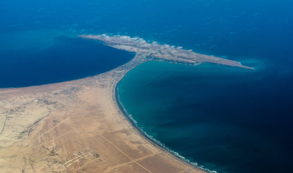
Figure 1.3 Gwadar Peninsula
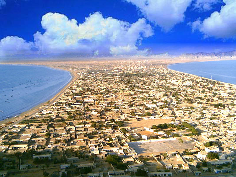
Figure 1.4 Aerial View of Gwadar City
Rivers, Streams, and Lakes of Gwadar district
The main rivers of the district are Dasht River in Jiwani, Shadi Kaur in Pasni, Ankara Kaur in Gwadar, and Basol in Ormara. All these are seasonal rivers which remain dry most of the year but remain in flood during rains. These rivers have numerous tributaries. Nilag and Dadeh are important tributaries of River Dasht. Hadi Wad is the only natural spring.
Other smaller intermittent streams include Wadi Kaur, Ghaz Ab Kaur, Kharodi Kaur, and Chedgi Kaur.
There are 2 water storage dams which provide drinking water to the district; these are the Ankara Kaur Dam and Shadi Kaur Dam. The reservoirs of these dams are the only lakes in the district.
Forests in Gwadar district
The forest resources of the district are meager. There are 2 representative forest types in the district; these are Dry Tropical Forests and Tropical Mangrove Forests. In Dry Tropical Forests, the climax formation is reduced to scrub condition due to grazing and fuel wood pressures. Presently, it is with very open cover and a moderate amount of bushes and grasses. The following table shows the type and area of forests in the district (Balochistan Development Statistics 2018-19):
| Total Forest Area | 76680 A | Coniferous Forests | – A |
| Irrigated Plantation | – A | Riverine Forests | – A |
| Scrub Forests | 35,840 A | Mangroves/Coastal Forests | 40,840 A |
Table 1.3 Gwadar Forests
Small scale mesquite plantation was carried out under the Natural Resource Management Project for sand-dune stabilization in a few areas of the district. Limited rangeland and scattered trees are found in many areas. Only a few types of trees are used for timber while others are used for fuel wood.
The Mangrove forests of the district extend from Kalmat Khor to Jiwani along the coast. These Mangroves provide vital breeding areas for commercially important fish species. The major Mangrove areas of the district are the Kalmat Khor and Gwadar Bay (Jiwani). The main tree species of these Mangroves are grey Mangrove (Avicennia marina), Mangrove (Rhizophora mucronata) and Mangrove (Ceriops tagal).
The scrub forests are found at elevations between 500 and 1,500 m. The main tree species in these forests are the mazri palm (Nannorhops ritcheana), with vegetation mixed with jand (Prosopis), babul/kikar (Acacia), and ber (Zizyphus) species. In Tropical Mangrove Forests, the major species are Avicenia marina, Rhizophora mucronata, and Ceriopstagal with Avicenia marina being the dominant species regarding frequency of occurrence.
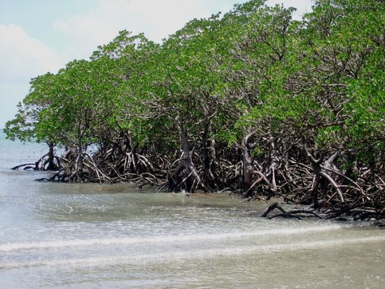
Figure 1.5 Mangroves, Gwadar, Balochistan
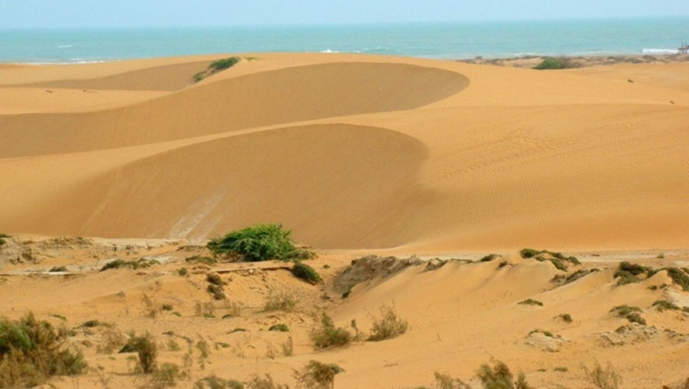
Figure 1.6 Sand-Dune Plantation
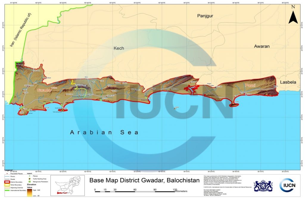
Figure 1.7 IUCN GIS Map Gwadar District
Soils of Gwadar district
The district contains 2 types of soil:
- Alluvial soil: the valleys of Dasht River in the western part, and the Kulanch Valley in the north consist of alluvial soil
- Lithosol and rigosol soils: the mountainous areas of the district are covered with these type of soils. Limestone, shale, and sandstone are the main rocks involved in formation of this area. Volcanic rocks also cover some parts of the district
Climate of Gwadar district
Due to great variance in the altitude of the district, the climate also varies. In the 0-300 m altitude areas, the climate is dry and hot, and is placed in the “warm summer and mild winter” temperature zone. The oceanic influence keeps summer temperatures lower, and winter temperatures higher than hinterland areas. Uniformity of temperatures is a unique characteristic of the coastal region in Balochistan. The winter season lasts for 3 months, from December to February, and is pleasant except for occasional and brief cold spells. January is the coldest month with mean maximum and minimum temperatures of 25 °C and 13 °C.
The summer season lasts from April to November, with June being the hottest month when the mean maximum and minimum temperatures are about 35 °C and 27 °C (30 year climatic data recorded at Pasni). The climate is arid with erratic rainfall. Most of the rainfall occurs between December and February with a monthly average rainfall of 20 mm. In the remaining 9 months of the year, the highest rainfall is 12 mm in the month of August. According to the 30 year recorded data at Pasni, average annual rainfall of the district is 101 mm.
Seismic Activity Gwadar district
The district belongs to Zones 3 and 4 of the Seismic Zone Map of Pakistan, which means major to moderate damage due to earthquakes.
[1] Isthmus is a narrow strip of land with sea on either side, forming a link between two larger areas of land.
[2] Promontory is a point of high land that juts out into the sea or a large lake; a headland.
[3] Both paragraphs have been paraphrased from a blog named hamaragwadar,com [our Gwadar]
[4] Integrated Development Vision, Gwadar District by IUCN Pakistan.
Population Gwadar district
The following table shows the population of the district according to the 2017 Census:
| Tehsil/ Taluka |
Area Km |
Population | Male% | Female% | Urban % | Growth Rate % | ||||||
| Gwadar District | 12,637 | 263,514 | 53.8 | 46.2 | 61.3 | 1.86 | ||||||
| Gwadar Tehsil | 5,019 | 138,438 | ||||||||||
| Pasni Tehsil | 7,618 | 61,396 | ||||||||||
| Jiwani Tehsil | Part of Gwadar Tehsil | 37,953 | ||||||||||
| Ormara Tehsil | Part of Pasni Tehsil | 25,727 | ||||||||||
Table 1.4 Gwadar Population Statistics
Religions Gwadar district[1]
| Muslims | 99.3% |
| Christians | 0.1% |
| Hindus | 0.2% |
| Ahmadis | 0.1% |
| Scheduled Castes | 0.2% |
| Others | 0.1% |
Table 1.5 Gwadar Religions
Languages Gwadar district[2]
| Urdu | 0.4% |
| Punjabi | 0.8% |
| Sindhi | 0.3% |
| Pushto | 0.3% |
| Balochi | 97.8% |
| Seraiki | 0.1% |
| Others[3] | 0.3% |
Table 1.6 Gwadar Languages
[1] 1998 Census; 2017 Census Data has not been made public yet.
[2] 1998 Census; 2017 Census Data has not been made public yet.
[3] includes Brahui etc.
Economic Activity – Economic Infrastructure
Economic Activity; Gwadar district
Gwadar is a port city and so its economy is based on fishing. The city also houses the industries of textile, construction, building material, and shipping. The major economic occupations of the district are:
- Agriculture with its allied livestock breeding and fishing (43.8%)
- Community, Social & Personal Services (21.6%)
- Construction (16.2%)
- Wholesale, Retail Trade & Restaurant (7.6%)
- Transport, Storage & Communication (7.4%)
- Manufacturing (1.7%)
- Others (1.8%)
Land Use; Gwadar district
The following table shows the main land use statistics of the district as per Balochistan Development Statistics 2018-19:
| Total Area | 1,263,700 HA | Reported Area | 397,494 HA |
| Total Cultivated Area | 179,165 HA | Net Sown | 2,472 HA |
| Current Fallow | 176,693 HA | Total Uncultivated Area | 218,329 HA |
| Culturable Waste | 28,713 HA | Forest Area | 7,511 HA |
Table 1.7 Gwadar Land Use Statistics
Irrigation Network; Gwadar district
The district is mostly a barani district and depends on rain water for agriculture. The following table shows the mode of irrigation and area being irrigated by the mode (Balochistan Development Statistics 2018-19):
| Total Irrigated Area | 2,472 HA | Government Canals | – HA |
| Private Canals | – HA | Wells | – HA |
| Tube Wells | 2,472 HA | Karez/Spring/Others | – HA |
Table 1.10 Gwadar Irrigation Statistics
The Shadi Kaur Dam and Ankara Kaur Dam provide some water for irrigation, but this water is limited. The Government of Balochistan is planning to construct 2 small dams in the district; these are the Miskin Delay Action Dam and Roomro Dam.
Agriculture; Gwadar district
The district is included in the Dry Western Plateau Agro-Ecological Zone of Pakistan; farming in the region is mostly barani or rain-fed based on subsistence level farming, and the land is mostly irrigated by streams, springs, tube wells, and open surface wells. The remaining land is rain-fed. Due to a scarcity of water, very little geographical area of the district is dedicated to agriculture.
The crops of the district include barley, masoor, jowar, bajra, maash, guar seed, masoor, and fodder.
The fruits grown in the district are dates, mangoes, citrus, guava, watermelon, musk melon, bananas, papaya, and coconut.
The vegetable produce of the district includes coriander, tomatoes, okra, radish, spinach, turnip, cabbage, carrots, pumpkin, cauliflower, and brinjal.
Livestock Breeding; Gwadar district
Livestock is an important sector of the economy. It is the main source of income for nomadic families. The following table shows the position of the Livestock Population in the district as per the 2006 Census of Livestock (qtd. in Balochistan Development Statistics 2018-19):
| Cattle | 12,344 Heads | Buffaloes | 51 Heads | Sheep | 18,363 Heads |
| Goats | 88,901 Heads | Camels | 1,432 Heads | Horses | 12 Heads |
| Mules | 18 Heads | Asses | 4,052 Heads |
Table 1.8 Gwadar Livestock Statistics
Lassi camel and Balochi sheep are the indigenous breeds of livestock in the district.
Poultry Farms; Gwadar district
There are 06 poultry farms[1] in the district. According to Punjab Development Statistics 2018-19 there are 52,893 poultry birds in the District.
Fishing in Gwadar district
Since Gwadar is a coastal district, the dominant economic activity of the region is fishing and its allied occupations. The district coastline stretches for 600 km, which means it comprises 78% of the provincial coastline and 55% of the coastline of the entire country. Owing to a lack of irrigation water, agriculture is minimal, and livestock population is meager, making the people of Gwadar dependent on fishing for their livelihood. All the 4 tehsils of the district, thus, have well-established and productive fish harbors besides the fishing villages at Peshukan, Surbandar, and Gunz. There is a government-owned and managed fish harbor at Gwadar. Popular fish species of the district are cod, tuna, and salmon. However shrimps, lobsters, and prawn are also in abundance.
On the coast of Pakistan, there are more than 30 species of shrimps, 10 species of crabs, 5 species of lobster, and about 70 commercial species of fish including sardine, hilsa, shark, mackerel, butterfish, pomfret, sole, tuna, sea bream, jew fish, cat fish, and eel.
The Mangrove forests of the district provide good breeding ground for shrimps.
Figure 1.8 Gwadar Coast
Bee Keeping/Apiary; Gwadar district
Only wild honey is locally used in the district and bee keeping is not a commercial/economic activity.
[1] Table 17 Number of Commercial Poultry Farms and Number of Birds by Size of Flock
Minerals and Mining Gwadar district
There are no minerals in the district.
Industry in Gwadar district
There is one Small Industries Estate that houses Small and Medium Enterprises.
At present, industries like power generation, ice plants, and a few furniture making units are operating in the district. Power generation plants include Pasni Power House, Gwadar Power Plant, and Jiwani Power Plant. These are small power houses and produce enough energy to supply electricity to urban areas of the district.
Handicrafts of Gwadar district
The handicrafts of the district include embroidery on clothes, sandals/shoe making, boat making, furniture making, and production of household items made from the leaves of the Mazri Palm.
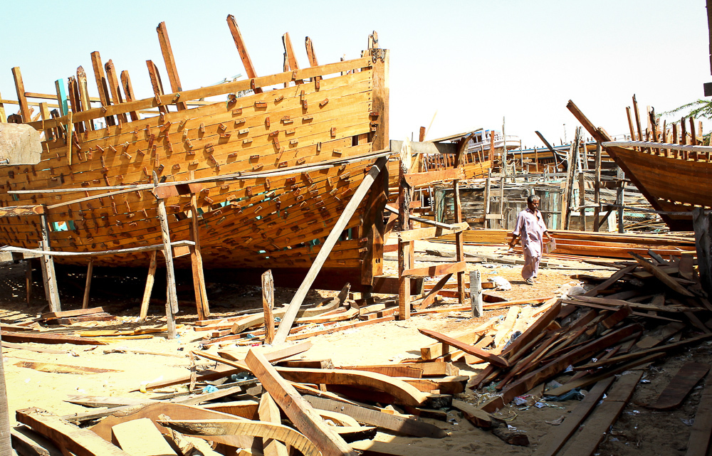
Figure 1.9 Boat making Industry, Gwadar
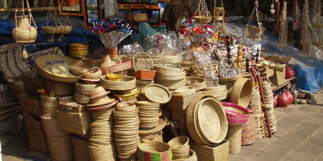
Figure 1.10 Items made from Mazri Palm Leaves
Economic Infrastructure; Gwadar district
Gwadar is connected to other cities by road and air. The district lacks a strong road and rail infrastructure, nor does it have well-developed structures like jetties and harbors.
Gwadar sea port—which is deeper than the Karachi sea port—is being developed by China on a turn-key[1] basis. Multiple highways and roads are also being developed. These include a road called Gwadar-Kalato Road linking Gwadar with the Iranian border, as well as one called Khuzdar-Rattodero, which will link Gwadar to Motorway M-8 (connecting Sukkur and Larkana to Gwadar) and that will shorten the distance between Gwadar, Punjab and Khyber Pakhtunkhwa.
The district is not connected by rail or air to other parts of Pakistan.
[1] Turn-key projects are contracted to contractors who are responsible for the design, construction and equipment of the project, and who then hand over the projects to owners for a remuneration
Road statistics; Gwadar district
According to the Balochistan Development Statistics 2018-19, the road statistics of the district are as follows:
| Total Roads | 1,342.0 km |
| High Type Roads/black topped | 408.0 km |
| Low Type Roads/Shingle | 934.0 km |
Table 1.9 Gwadar Road Statistics
Some of the important roads of the district include
- Makran Coastal Highway (N-10) connects Karachi with Gwadar passing through Ormara, and Pasni
- Gwadar-Ratodero Road links Gwadar to Super Highway (M-9), RCD Highway (N-25), and National Highway (N-5)
- Jiwani Road
- Pasni Road
Rail and Airways; Gwadar district
At present, there is no rail link from Gwadar district to other parts of Pakistan, but there are plans to connect Gwadar with Khunjerab and ultimately to China.
There are 4 commercial airports in the district, with one each at Gwadar, Pasni, Ormara, and Jiwani. Gwadar and Pasni Airports are international airports, while those at Ormara and Jiwani are domestic.
Radio and Television; Gwadar district
Gwadar district is out of Pakistan Television’s transmission range, but television can be viewed through cable.
Pakistan Broadcasting Corporation (Radio Pakistan) has one broadcasting station at Turbat. In addition, there are 2 privately-owned FM radio stations in the district.
Telecommunications; Gwadar district
The district is connected to other parts of the country through telephone and telegraph. There are 04 telephone exchanges in the district which provide 1,102 landline connections, 399 wireless phone connections, and 1,052 broadband connections in the District (Balochistan Development Statistics 2018-19). Cellular phone companies also provide their services in the district.
Post Offices/ Courier Services; Gwadar district
There are 06 post offices in the entire district (Balochistan Development Statistics 2018-19). Courier companies provide services in the district as well.
Banking/ Financial Institutions; Gwadar district
According to the List of Reporting Bank Branches 2019, provided by the State Bank of Pakistan, the following banks have their branches in the district:
- Askari Bank
- Allied Bank
- Bank Alfalah
- Dubai Islamic Bank Pakistan
- Habib Bank Ltd.
- Muslim Commercial Bank
- National Bank of Pakistan
- NIB Bank Ltd.
- Soneri Bank Ltd.
- Standard Chartered Bank Ltd.
- United Bank Ltd.
In all there are 39 branches of various conventional banks and 06 branches of different Islamic banks in the District.
Electricity and Gas; Gwadar district
Quetta Electric Supply Company (QESCO) looks after the supply and transmission of electricity to the district.
Educational Institutions; Gwadar district
The following table shows the number of primary, middle, secondary, and mosque schools in the district as per Balochistan Development Statistics 2018-19:
| Institution | Boys/Girls | Institution | Boys/Girls |
| Primary Schools | 149/73 | Middle Schools | 22/08 |
| High Schools | 16/10 | Community Schools | 12 |
| Higher Secondary | 02/02 | Degree Colleges | 01/- |
| Universities | – | Mosque Schools[1] | – |
| Vocational Training Schools | 01 | Private Schools | 03 |
Table 1.11 Gwadar Educational Institutes
Healthcare Facilities; Gwadar district
The following table shows the Government Health Care Institutions in Gwadar district as per Balochistan Development Statistics 2018-19:
| Institution | No./beds | Institution | No./beds |
| Teaching Hospitals | – | Hospitals | 02/63 |
| Rural Health Centers | 03/58 | Basic Health Units | 22/- |
| Dispensaries | 15/- | Mother Child Health Centers | 03/- |
| TB/Leprosy Clinics | 01/- | Private Hospitals | 01/05 |
Table 1.12 Gwadar Health Institutions
Policing; Gwadar district
Gwadar district is divided into two areas as far as law enforcement is concerned. Area “A” is controlled by the Balochistan Police while area “B” is controlled by Balochistan Levies Force. The Regional Police Officer (RPO) Makran is in charge of the Police Force. This RPO is assisted by 3 SubDivisional Police Officers (SDPOs) stationed at Gwadar, Pasni, and Jiwani. There are 4 police stations in the district (19.7 (a) Number of Police Stations by Division/District by federal Bureau of Statistics, 2019).
There is another armed force called Coast Guards under the Naval Commandant for vigilance at sea. The Pakistan Navy and Pakistan Maritime Security Agency are also deputed at various points in the district.
Justice is administered through regular as well as Qazi Courts.[2]
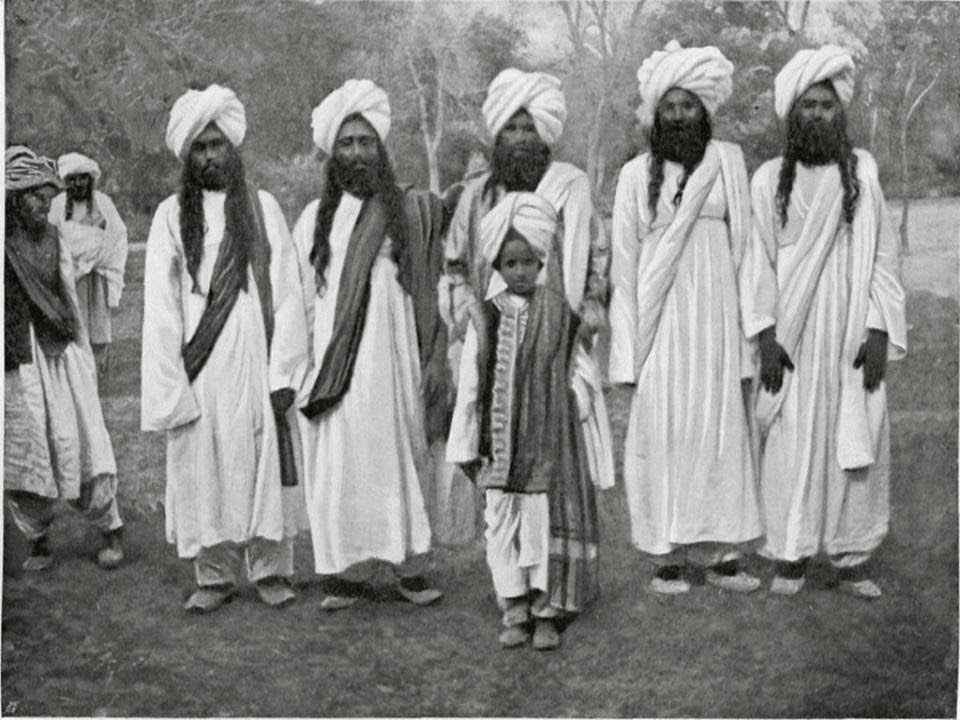
Figure 1.11 Traditional men’s attire worn by Gwadar’s Indigenous Society
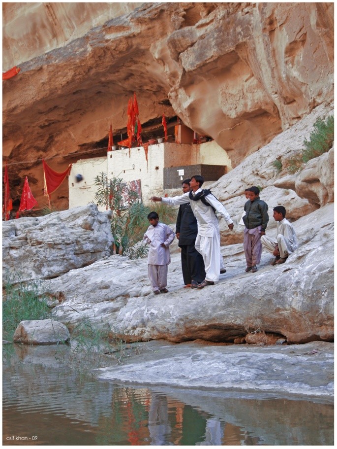
Figure 1.12 Nani Mandir, Gwadar
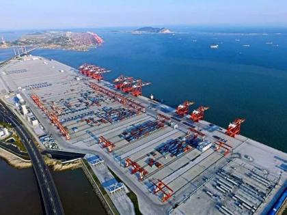
Figure 1.13 Development work at Gwadar Sea Port
[1] included in primary schools
[2] Qazi courts were established in 1976 and have the same powers as those of civil, family, and rent courts. However, in tribal areas, they provide justice to private parties under the provisions of sharia laws.
Environment and Biodiversity Gwadar district
Erosion of the coastal areas by the sea is a major problem in Gwadar and Pasni, as the district is a coastal district. Oil pollution due to use of fishing boats, merchant vessels, and oil tankers is a major threat to the marine ecology of the coastline.
This coast is one of the most active seismic zones in Pakistan, putting it at risk of major damage due to earthquakes and tsunamis.
Flora and Fauna
Flora of Gwadar district
There is very little vegetation in the district. Most common trees found throughout are peelu (Salvadora oleoides), kandi (Prosopis cineraria), ber (Zizyphus nummularia), date palm (Phoenix dactylifera), gaz (Tamarix sp.), kikar (Acacia senegal) and kotor (Cadaba ferinosa). The most common shrubs/bushes include. jhil (Indigofera oblongifolia) and desert thorn (Lycium depressum), laani (Suaeda fruticosa), bui (Aerva persica), and lai (Tamarix dioica).
The most common Mangrove species are Avicenia marina, Rhizophora mucronata, and Ceriops tagal. The main shrubs are Euphorbia cauduicifolia, Haloxylon sp., Calligonum polygonoides, gugul (Commiphora mukal), merin (Heliotropium sp.), gujo (Aerva javanica), aak (Callotropis procera), camel thorn (Alhaji camelerom) and mazri (Nannorrhops ritchieana). The ground cover is constituted mainly by grasses like Eliosine sp., Lasiurus sp., Chrysopogon sp., Aristida sp. and Cymbopogon sp.
Vegetation zones of the district consist mainly of the following categories:[1]
- Hills: The tree and bush species in the hills are ber/jhar beri (Zizyphus nummularia), gum Arabica (Acacia Senegal), vann (Salvadora oleoides) and mazri palm (Nannorrhops ritchieana)
- Plains: The main species in the plains are kandi or jhand (Prosopis cineraria), babul/kikar (Acacia nilotica), vann (Salvadora oleoides) and ber (Zizyphus nummularia)
- River and stream beds: Common flora naturally occurring on alluvium patches along the rivers includes salt cedar (Tamarix spp.), kandi (Prosopis cineraria) and the invasive alien species jhand (Prosopis juliflora)
- Sand dunes on the coastal front: On the dry sandy saline shore, Urochondrasetulosa (a grass) is common. Also found are the following grasses: Sporoboluskenthrophyllus, Dactuloteniumaristatum, and Ochthochloacompressa. Other scrubs in this area include Heliotropiumcrispum, Haloxylon sp., Tamarix sp., Suaeda sp. and Salsola sp.
- Inter-tidal swamps: The Mangrove species are Avicenia marina, Rhizophoramucronata, and Ceriopstagal
Since a part of the Hingol National Park falls inside the borders of Gwadar district, the district itself also houses the same flora and fauna. The Hingol National Park is home to around 250 varieties of plants, and there are some unknown and unnamed varieties of plants as well. Some of the trees in the park are babul (Acacia nilotica), khor (Acacia Senegal), gazz (Tamarix aphyla), and ber (Zizyphus mauritania). The bushes include aak (Calotropis procera), karir (Capparis decidua), guggul (Commiphora wightii), and rattle box or rickachic (Crotalaria persica). The grasses include khavi grass (Cymbopogon jwarancusa), while some of the herbs include sheer bar (Euphorbia granulate), sirin (Cassia italica), bitter gourd (Citrullus colocynthis), munderi (Corchorus depressus), and chhipri (Neurada procumbens).[2]
Fauna of Gwadar district
Hingol National Park supports 35 species of mammals, 65 varieties of amphibians and reptiles, and 165 types of avifauna. Some of the mammals include Sindh ibex, Afghan urial, chinkara gazelle, jackals, honey badger, hedgehog, leopard, pangolin, shrews, bats, flying fox, red lynx, jungle cat, sand cat, desert wolf, caracal, Asiatic jackal, wild boar, and black bear.
Amphibians of the park include marsh crocodile, green turtle, masher fish, olive ridley turtles, desert monitor lizard, varieties of chameleons, and yellow monitor lizard.
Avifauna of the park include Lagger falcon, red-headed merlin, kestrel, grey partridge, eagle owl, Sind pied woodpecker, finch larks, hoopoe, shrikes, wheatears, 3 varieties of vultures (namely: Eurasian griffon vulture, Egyptian vulture and the cinereous vulture), and sand grouse. The houbara bustard, Dalmatian and spot-billed pelican are regular visitors to the area.
Mammals of the district include caracal, honey badger, chinkara, ibex, urial, striped hyena, wolf, Bengal fox, Asiatic jackal, cape hare, porcupine, and hedgehog. Sometimes, plumbeous dolphin can be observed along the coastal areas of the district.
Avifauna of the district include wheatears, common babblers, larks, sand grouse, partridges, the houbara bustard, shrikes, buntings, bee-eaters, hoopoes, pigeons, doves, brown-headed raven, owls and birds of prey (eagles, vultures, hawks, buzzards, and falcons). The major birds found along the coast line, lagoons, and estuaries are seagulls, terns, pelicans, flamingos, herons, egrets, plovers, lapwings, stints, sandpipers, godwits, shanks, coots, curlews, kingfishers, and Osprey.
The coastal areas are a refuge for the green and olive ridley turtles. Previously, marsh crocodiles were common in the rivers, but now they are rare. Spiny-tail lizard, black rock agama, and monitor lizard are common lizards found in the district. Among snakes, the common krait, 2 types of cobras (the common cobra and the brown or oxus cobra) and vipers like saw-scaled sand viper and horned viper are commonly found in the district.[3]
Protected Areas and Wildlife Gwadar district
The Hingol National Park and Buzi Makola—a tropical thorn forest/Wildlife Sanctuary—are the wildlife protected areas of the district. In addition, Gwadar has Ramsar designated wetlands of international importance, protected under the Government of Pakistan Laws. These include the Astola Island or Jazira Haft Talar (Pakistan’s largest off-shore island), Jiwani Coast Mangroves, and Ormara Turtle Beaches.
The wildlife of Hingol National Park (situated in the Hingol River Basin) include leopard, jungle cat, caracal, Indian desert cat, Indian fox, Bengal fox, and sand fox, golden jackal, Sindh ibex, Afghan urial, chinkara gazelle, honey badger, Indian pangolin, hedgehog, Indian crested porcupine, Indian grey mongoose, five-striped palm squirrel, wild boar, cape hare, and desert hare, Cairo spiny mouse, grey spiny mouse, Persian jird, Indian desert jird, and Libyan jird, house mouse, roof rat, and mouse-like hamster, wolf (canis lupus pallipes), striped hyena (hyaena hyaena), houbara bustard, dalmatian and spot-billed pelican, Bonnelli’s eagle, imperial eagle, tawny eagle, golden eagle, Eurasian griffon vulture, Egyptian vulture, cinereous vulture, lagger falcon, red-headed merlin, kestrel, close-barred sandgrouse, grey partridge, stone curlew, Indian sand grouse, coroneted sand grouse, painted sandgrouse, eagle, owl, Sind pied woodpecker, Hume’s chat, brown rock pipit, striped bunting, finch larks, hoopoe, shrikes, wheatears, marsh crocodile, olive ridley turtles, green marine turtles, desert monitor lizard, and yellow monitor lizard.
The Buzi Makola Wildlife Sanctuary provides protection to Sindh ibex, chinkara gazelle, Afghan urial, black bear, marsh crocodile, houbara bustard, and green turtles, as well as endemic and threatened species of fish such as mahaseer and plumbeous dolphins.
The Makran Coastal Wetlands provide sanctuary to significant areas of coral, Mangrove swamps and sea grass, threatened marine turtles, the endangered marsh crocodile, large seasonal accumulations of migratory birds and approximately 10 species of marine cetaceans.
Jiwani Sea Mount and the areas of the rocky shore-line, estuaries, and associated Mangroves are vital breeding areas for commercially important fish species. A sub species of saw-scaled viper named Echis carinatus astoli has recently been discovered by a German scientist.
The Akara Dam Reservoir Site, Pasni Bay, Astola Island and Dasht Kaur/River are designated Ramsar sites of international importance. They provide sanctuary to a large number of migratory birds like little grebe, flamingoes, goose, Eurasian coot, and mallards.
The Ormara Turtle Beach is a 10 km long sandy beach along the shores of the Arabian Sea. This is also a designated Ramsar Site to provide protection to a considerable number of marine turtles, particularly the endangered olive ridley and green turtles and possibly the hawksbill turtle as well.
[1] Provincial and District Forest Departments, IUCN, UNDP, WWF, GEF
[2] Medicinal Flora of Hingol National Park, Baluchistan, Pakistan by Rahmatullah Qureshi
[3] Provincial and District Forest Departments, IUCN, UNDP, WWF, GEF