Share now
Map of Balochistan

Map of Quetta District

Balochistan Districts
- Quetta District Profile
- Awaran district Profile
- Barkhan District Profile
- Bolan District Profile
- Chagai District Profile
- Dera Bugti District Profile
- Gwadar District Profile
- Harnai District Profile
- Jaffarabad District Profile
- Jhal Magsi District Profile
- Kalat District Profile
- Kech District Profile
- Kharan District Profile
- Khuzdar District Profile
- Killa Abdullah District Profile
- Killa Saifullah District Profile
- Kohlu District Profile
- Lasbela District Profile
- Loralai District Profile
- Mastung District Profile
- Musakhel District Profile
- Nasirabad District Profile
- Nushki District Profile
- Panjgur District Profile
- Pishin District Profile
- Sherani District Profile
- Sibi District Profile
- Washuk District Profile
- Zhob District Profile
- Ziarat District Profile
Also visit: Sindh, Punjab, Khyber Pakhtunkhwa
Introduction/Geographical Details Quetta
Quetta is the provincial capital of Balochistan, and is located between 66° 41′ 40″ to 67° 17′ 25″ east longitudes and 30° 01′ 29″ to 30° 28′ 25″ north latitudes. The district is bordered by Pishin district in the northwest, Chagai district and Afghanistan in the south, Mastung district in the east and Sibi district in the north.
The name Quetta is a derivation of the Pushto word “kwatta” which means “a fort.” It is still known as Shalkot locally, based on its location at the north-end of the Shal valley.
Quetta District at a Glance
| Name of District | Quetta City District | ||
| District Headquarter | Quetta Town | ||
| Population[1] | 2,275,699 persons | ||
| Area[2] | 2,653 km2 | ||
| Population Density[3] | 830.3 persons/ km2 | ||
| Population Growth Rate[4] | 5.8% | ||
| Male Population[5] | 52.5% | ||
| Female Population[6] | 47.5% | ||
| Urban Population[7] | 44% | ||
| Tehsils/Talukas |
2 Towns: 1. Chilton Town 2. Zarghoon Town |
||
| Main Towns | Quetta City, Kuchlak, Zarghoon, Chiltan, Panjpai, Quetta Saddar, Hazar Ganji, Kachi Baig, Kili Shabo, Kirani, and Hazara town | ||
| Literacy Rate[8] | 70% | ||
| Male Literacy Rate[9] | 85% | ||
| Female Literacy Rate[10] | 52% | ||
| Major Economic Activity[11] | Community, Social & Personal Services | 45.4% | |
| Wholesale, Retail, Hotel/Restaurant | 15% | ||
| Construction | 13% | ||
| Manufacturing | 10% | ||
| Agriculture, Forestry, Fishing & Hunting | 7% | ||
| Others | 9.6% | ||
| Main Crops | Wheat, barley, fodder, cumin, and canola | ||
| Major Fruits | Almonds, apples, apricots, grapes, peaches, pomegranate, plums, cherries, watermelon, and musk melon | ||
| Major Vegetables | Onions, potatoes, radish, spinach, turnip, broad beans, cabbage, carrots, bitter and bottle gourds, pumpkins, cauliflower, peas, brinjal, luffa, cucumber, chilies, and okra | ||
| Forests (Area)[12] | 34,620 HA[13] | ||
| Black Topped Road[14] | 1,602 km | ||
| Shingle Roads[15] | 402 km | ||
| No. of Grid Stations[16] | There are 7 grid stations and 2 power houses with capacity of 140 and 175 MW respectively | ||
| No. of Tel. Exchanges[17] | 12 Telephone Exchanges with 37,861 landlines, 550 wireless phones and 22,651 broadband connections | ||
| Industrial Zones[18] |
Two industrial estates: · Mini Industrial Estate, Sirki Road · Quetta Industrial and Trading Estate (QITE), Saryab Bypass |
||
| Major Industry[19] | Food/Beverages | 43 Units | |
| Marble | 9 Units | ||
| Furniture | 8 Units | ||
| Steel Rerolling | 7 Units | ||
| PVC Pipes | 5 Units | ||
| Power Generation | 1 Unit | ||
| Chemicals/Soaps | 5 Units | ||
| Cement | 2 Units | ||
| LPG | 5 Units | ||
| RCC Pipes | 7 Units | ||
| Ice/Cold Storage | 8 Units | ||
| Others | 17 Units | ||
| Household Size[20] | 8.5 persons per house | ||
| Houses with Piped Water[21] | 94.1% | ||
| Houses with Electricity[22] | 79.8% | ||
Table 1.1 Quetta District at a Glance
[1] 2017 Census
[2] 1998 Census
[3] 2017 Census
[4] 2017 Census
[5] 2017 Census
[6] 2017 Census
[7] 2017 Census
[8] Pakistan Social & Living Measurement Survey 2014-15 (PSLM); latest available.
[9] PSLM
[10] PSLM
[11] 1998 Census; 2017 Census Data has not been made public yet.
[12] Balochistan Development Statistics 2018-19
[13] Land Utilization Statistics report 80,816 HA under forests.
[14] Balochistan Development Statistics 2018-19
[15] Balochistan Development Statistics 2018-19
[16] GoB Official Website, Economic Infrastructure, Quetta. Retrieved in Sept 2014
[17] Balochistan Development Statistics 2018-19
[18] Quetta District Development Profile, 2011. P&D Department. GoB, with UNICEF.
[19] Quetta District Development Profile, 2011. P&D Department. GoB, with UNICEF.
[20] 1998 Census; 2017 Census Data has not been made public yet.
[21] 1998 Census; 2017 Census Data has not been made public yet.
[22] 1998 Census; 2017 Census Data has not been made public yet.
Brief History – Governmental Structure – Administrative Divisions – Heritage Sites/ Tourist Attractions
Brief History of Quetta District
From the 10th century to the middle of the 19th century, Quetta was referred to by its ancient name Shalkot. The old Quetta settlements appear to have existed as far back as 5 millennia, corroborated by discoveries made during excavations in the village of Killi Gul Mohammad[1] and Balleli.[2]
According to the Balochistan Provincial District Gazetteer (Quetta-Pishin District):
We know little of the history of Quetta-Pishin[3] up to the thirteenth century A.D. It certainly formed part of the kingdom of Amir Sabuktagin and of Mahmud the Ghaznavid, for we hear of both those monarchs making expeditions so far south as Khuzdar. From them it must have passed to their successors, the Ghorid dynasty of Ghazni. (pg 32)
Up to the middle of the 18th century, the history of Quetta district is identical to the history of Kandahar (Afghanistan). It is known that in the 11th century, it was a part of the Graeco-Bactrian Empire.[4] After that, the region was controlled by the Kingdom of the Amir Sebuktigin and Mahmood Ghaznavi till the 13th century (as recounted above).
In 1470, the Kandahar kingdom was succeeded by the Timurs. Between 1530 and 1545, the Province of Kandahar was in the possession of Mirza Kamran (the brother of Mughal Emperor Humayun).[5] During this period, Humayun arrived in Quetta after being defeated by the forces of Sher Shah Suri in India. His uncle, Mirza Askari, was the governor of Kandahar on behalf of Mirza Kamran. While in Quetta, Humayun received the news of Mirza Askari’s impending attack which prompted him to leave his son Akbar (then only one year old) in Quetta with some of his faithful followers. He himself escaped via Nushki to Garmsel and Herat (Afghanistan). On his return 2 years later, Kandahar passed into Humayun’s rule. 4 years after Humayun’s death (1556), Kandahar and its dependencies were ordered by Emperor Akbar to be restored to the Safavid[6] kings of Persia. The territories remained under Persia until 1595, when they were again acquired by the Mughals. At this time, it can be deduced from Ain-i-Akbari [the Constitution of Akbar[7]], that Shal (Quetta) and Pushang (Pishin) were included in the eastern division of the Kandahar Sarkar [principality].
In 1622 AD, Kandahar was brought back under the sway of the Safavid Dynasty and remained under its dominion until 1709, till the rise of the Ghilzai Dynasty under Mir Wais.
According to the Imperial Gazetteer of India (v.21, p.13), at the time of the rise of Chilzai/Khilji power in Kandahar, the Brahvi power was rising in Kalat. Both Quetta and Pishin became a battleground between the Afghans and the Brahvis. In 1733 Shah Hussain Chilzai attacked the Brahvis. He first garrisoned the fort of Pishin and then moved towards Quetta and succeeded in capturing it. He then moved towards Mastung where the Brahvis surrendered, while Quetta, after being captured by the Chilzais, remained under them. In 1751 Ahmad Shah Durrani[8] conferred it on the Brahvis after the campaign in eastern Persia, as a fief after Nasir Khan I (the then Khan of Kalat) helped him. A legend by the Brahvis states that Ahmad Shah, while bestowing the district to Nasir Khan’s mother, Bibi Mariam, said “This is your shal [your present].”
Quetta was first visited by a British traveler, Mr. Masson, in 1827; he described Quetta as a mud-walled fort surrounded by 300 mud-houses. The British occupied it during the First Anglo-Afghan War in 1839, but they had to hand Quetta, along with Kachhi and Mastung, to Shah Shuja-ul-Mulk (ruler of Afghanistan), appointing Captain Bean as the first Political Agent in Shal (Quetta). The region was managed by him on behalf of Shah Shuja-ul-Mulk of Afghanistan.
At the end of the First Anglo-Afghan War in March 1842, the Khan of Kalat (Mir Nasir Khan II) re-occupied Quetta and Quetta remained under Kalat’s rule till 1876, when it was occupied by Sir Robert Sandeman.[9] The region was managed on behalf of the Khan by Sandeman up till 1883, when it was leased to the British government for an annual rent of Rs. 25,000.
The Second Anglo-Afghan War was fought from 1878 to 1880. The war ended with the British emerging victorious. In May 1879, to prevent a British invasion of the rest of the country, a treaty called the Treaty of Gandamak was signed between Sir Robert Sandeman and Muhammad Yakub Khan, the then Monarch of Afghanistan, which signaled the end of the first phase of the war. According to this treaty, and in return for an annual subsidy and vague assurances of assistance in case of foreign aggression, the Afghans relinquished control of Afghan Foreign Affairs to Britain. British representatives were installed in Kabul and other locations, British control was extended to the Khyber and Michni passes, and Afghanistan ceded various North West Frontier Province (NWFP; now Khyber Pakhtunkhwa or KP) areas and Quetta to Britain. The British Army, then, withdrew from Afghanistan.
In 1883, Quetta, along with Pishin, was formed into a separate single administrative unit (Quetta-Pishin district). Due to its geo-strategic importance, the British built Quetta as a garrison town. They extended the roads and railway network to Afghanistan and Iran. With the passage of time, Quetta began to expand. The British paid special attention to its cleanliness. However, on 31 May, 1935, an earthquake destroyed Quetta city completely. Most of the cantonment area, however, survived. The reconstruction started soon after, and for the first time, serious and systematic efforts were made to design and implement earthquake-resistant methods of construction. The use of reinforced concrete at different levels in buildings, for example, began after this earthquake. This, and other actions taken in 1935, became the model for earthquake response in all the other earthquake-prone regions of India and Pakistan.
The Muslim population of Quetta supported the Pakistan Movement and the Muslim League. On joining Pakistan, Quetta was made the capital city of the newly created province of Balochistan before it was combined with other Balochi Princely States (Kalat, Makran, Lasbela, and Kharan). Quetta remained the capital of the province until 1955 when the provincial system was abolished under the One Unit[10] Policy. Under this policy, Quetta and Kalat were the administrative units in West Pakistan.
On the reinstatement of the provincial system in 1970, Quetta was once again made the capital of Balochistan.
Till 1975, Quetta-Pishin was a single administrative unit, and in 1975, Pishin was declared a separate district.

Figure 1.3 Quetta Cantonment c1889

Figure 1.4 Sandeman Hall, Quetta c1900
Governmental Structure; Quetta District
At the Federal level, Quetta city district is allocated a set number of representatives in both the National Assembly and the Provincial Assembly:
- Number of seats in the National Assembly 2
- Number of seats in the Provincial Assembly 6
The Balochistan government has adopted the Local Government Act 2010, amended in 2011. According to this Act, Quetta city district has 1 Municipal Corporation headed by a mayor with 66 members. There is one member who represents the government and assists the chairman and members in the daily functioning. In the rural areas of Quetta district, there are 8 Union Councils, which constitute a District Council. Each Union Council is represented by a member in the District Council. In addition, there is special representation of 2 women, 1 peasant, 1 non-Muslim, and 1 worker. Thus, a District Council is composed of 13 members; the Deputy Commissioner and Assistant Directors of various Departments are Ex-Officio members of this Council.
Administrative Divisions; Quetta District
The district has a total area of 2,653 km2 and is divided into 2 towns with 67 Union Councils as follows:
| Chiltan Town[11] | 30 Union Councils |
| Zarghoon Town[12] | 37 Union Councils |
Table 1.2 Quetta Administrative Divisions
The cantonment areas of urban Quetta are not under the formal jurisdiction of the City Government.
[1] A Pre-Harrapan archeological site, dating from the 5th and 6th millennia BC to the 1st half of the 4th millennia BC
[2] Baleli village is located in Killa Abdullah district (retrieved from Quetta District Integrated Development Vision, IUCN 2011)
[3] During the British rule the district was called Quetta-Pishin district. Pishin was separated from Quetta in 1975 and formed into a new district
[4] Balochistan Provincial District Gazetteer (Quetta-Pishin District)
[5]Quetta District Development Profile, 2011. P&D Department. GoB, with UNICEF
[6] Safavid Dynasty ruled over Iran from 1502-1736
[7] A detailed document recording the administration of Emperor Akbar’s empire
[8] Ahmad Shah Durrani was the founder of modern Afghanistan, with Kandahar as one of its provinces; Balochistan Provincial District Gazetteers, Quetta-Pishin
[9] Sir Robert Sandeman was the Political Agent over the warring Marri, Bugti and Mazari tribes of the Suleiman Hills at the Mithankot conference between the then governments of Punjab and Sindh provinces. In 1876 he negotiated a treaty with the Khan of Kalat and later became the Governor General of Balochistan in 1877.
[10] One Unit was a geo-political program under which the four provinces of West Pakistan were merged into a single province
[11] Chiltan hill ranges to the south of the city have provided the name for the town West of the railway line
[12] Zarghun, named after the hill ranges to the East of Quetta, has inherited most of the territory to the East of the railway track that runs in a north-south direction through the district
Historic/ Heritage Sites; Quetta District
The Quetta Valley is surrounded by mountains. The Hazarganji-Chiltan National Park is a major eco-tourism attraction in the district. The outer countryside and outdoor recreational resources also include Hanna Lake, Spin Karez, Karkhasa, orchards of Hanna-Urak, Central Zarghun Forest with Wali Tangi Dam and Askari Urban Park.
Other tourist attractions such as Ziarat, Bolan Pass, and Chaman are within easy reach from Quetta as is Bund Khushdil Khan.
The following important archeological sites of Quetta district are protected under Federal government laws:[1]
- Killi Gul Muhammad: This is a Neolithic to Bronze Age site, located 3 km northwest of Quetta city. It was discovered in 1949 and excavated in 1950. Cultural material recovered include chert blades, various types of painted pottery, bone spatula, and terracotta humped bulls figurine
- Kechi Beg: This is an Early Bronze Age site located 5 km south of Quetta. It was excavated in 1950. Various pottery types were discovered with biochrome, monochrome, and polychrome painted designs
- Damb Sadaat: This is an Early Bronze Age site. It was excavated in 1950 and yielded mud-brick walls on stone foundations. Cultural material includes painted pottery, bone implements, beads, scrapers, cores, and terracotta figurines of humans and animals
- Ahmad Khanzai: This is a Bronze Age site located 5 km south of Quetta Town. It was excavated in 1950, and yielded painted pottery of the Bronze Age, including beads of lapis lazuli and chalcedony
There are other important archeological/historical sites in the district which, though important, are not protected under Pakistan’s laws. These are Quetta Miri, Mound of Katir, Mound of Kuchlak, Mound of Tor Ghund, and Mound of Tor Wasi, as well as Quetta Residency (the home of Assistant Governor General of Balochistan and now used as a Governor House). Data on shrines is not available.[2]
Recreational Areas Quetta District
The recreational facilities include Hazarganji-Chiltan National Park, Mianghundi Recreational Park, Karkhasa Recreational Park, Askari Park, Liaquat Park, Shahbaz Park, Hanna Lake, Archeological Museum, Geological Museum, and Urak Valley.

Figure 1.6 Shahbaz Park, Quetta

Figure 1.7 Snow on Hanna Lake
[1] Balochistan Conservation Strategy, by IUCN Pakistan.
[2] Quetta District Development Profile by P&D Department GoB with UNICEF
QUETTA CUISINE
The main cuisine of Quetta which is the highest altitude major city of Pakistan are:
Sajji: A slow-roasted, marinated lamb or chicken dish that’s a local delicacy
Rosh: A traditional Pashtun dish of tender meat cooked in its own juices
Lahndi: A Balochi dish of preserved meat, usually mutton, stored in animal fat
Dampukht: A slow-cooked stew of meat and lentils with local spices
Khaddi Kabab: A goat stuffed with rice and dried fruit, cooked in a pit
The best places to eat these are:
Sajji: Lehri Sajji House; located on Sariyab road; Sajji is a traditional dish of marinated meat that’s slow-roasted over an open flame. It originated in Balochistan, Pakistan and is a key part of Baloch culture.
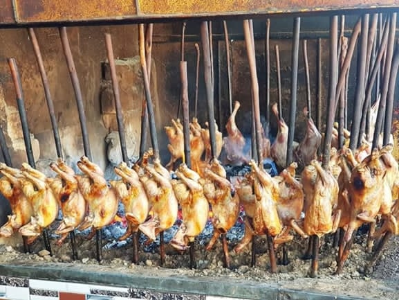 Mutton and Chicken Sajji; Lehri House Quetta
Rosh: Rosh is also called Namkeen Gosht and contains little to no spices except salt. The taste of the dish lies in its tenderness and earthy taste. The best rosh is available at Al Dubai Restaurant in Kuchlak ; Quetta.
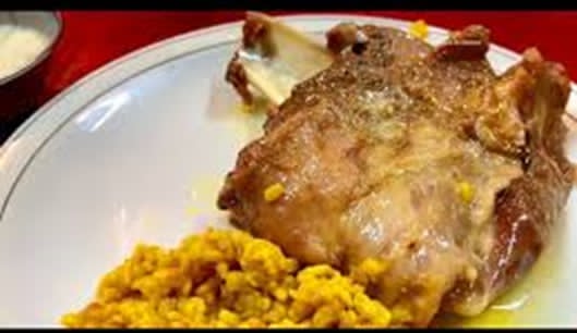 Rosh or Namkeen Gosht
Lahndi: This is a dried meat dish that is a winter delicacy in Quetta, Pakistan. It is made from sheep or goat meat that is salt-cured and dried. Lahndi is a popular dish in Balochistan and is often eaten by tribesmen during the winter. The best Lahndi in Quetta is at Balana Restauran Chaman Road Quetta;
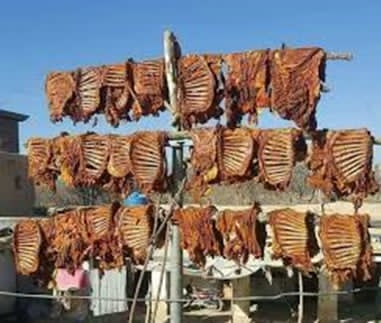 Lahndi Meat
Dumpukht: Dumpukht is a Pakistani dish of meat and vegetables slow-cooked in a heavy pot over low heat. The word “dum pukht” comes from the words “dum” and “pukht”, which mean “to keep food on slow fire” and “process of cooking”. This meat also originated in Balochistan.
The best restaurant for Dampukht is Balochi Resturant.
 Balochi Dumpukht
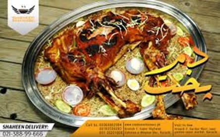
Khaddi Kabab: Khaddi kabab is whole lamb or goat cooked underground by placing the fire on top. This whole khaddi kabab weighs almost 10 to 12 kgs.
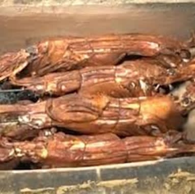 New Afghan Khadi kabab house Toghi road Quetta is the best place to eat this.
Topography of Quetta District
The district belongs to the Upper Highlands or the Khorasan Geographical Zone[1] of Balochistan. The general characteristic of the district is mountainous. The hill ranges are fairly uniform in character, consisting of long central ridges from which frequent spurs descend. These spurs are intersected by innumerable gorges and torrent beds with varied ground in elevations ranging from 1,254 to 3,500 m.
The mountains are intersected by long narrow valleys consisting of flat alluvial plains with heavily pebbled slopes rising on either side. The district is a valley which is surrounded by different hill ranges described in detail next.
Mountain Ranges; Quetta District
On the district’s north lies the Takatu range. The highest point in this range is 3,453 m above sea level. The Zarghun and Murdar Ranges lie on the east of Quetta Valley, with the highest point at Murdar Ghar, which is 3,166 m above sea level. The Chiltan range is in the south of the district separating Quetta from Mastung district. The Hazarganji forests are situated along this range. The Mashlak range is in the west of Quetta Valley.
The Quetta Valley is an elongated depression. In the south, the valley is bifurcated into 2 narrow valleys by the intervening hillocks of Landi, the eastern branch of which, after taking a slight easterly bend, joins the Spezand-Ismail Khan Valley in the south. The western branch terminates at Lak Pass. West of Quetta town, the valley has a gap extending from Samungli to Baleli through which it joins the Karanga Lora valley in the west.
The city itself is located beneath the Murdar Mountains, which bounds the Quetta Valley in the east.
Mountain Passes; Quetta District
Quetta city lies on the Bolan Pass route. The pass is located on the Toba Kakar Mountain Range and connects Jacobabad, Sibi, and Quetta.
The Lak Pass, Quetta, links Quetta and Kalat. This is where the RCD[2] Highway (National Highway N-25) makes a turn for Koh-e-Taftan and Zahidan in Iran.
Rivers, Streams, and Lakes; Quetta District
There is no perennial river in the district. The Quetta Lora comes out near Sariab and traverses the western side of Quetta Valley. This Lora carries rain and wastewater past Baleli and continues northward through the Kuchlak valley. The water of Quetta Lora is used for irrigation in villages like Khazi, Samungli, and Nohsar.
The Hanna stream is one of the most important sources of drinking and irrigation water in the district. It rises in the western slopes of the Zarghun Range near Urak, about 21 km northeast of Quetta. It enters Quetta Valley near the Staff College and drains its northern parts. The Hanna stream is joined by the Sora Khula and Ghundak Rud Nalla near Sheikmanda village. Hanna stream forms a lake—Hanna Lake—which is one of the major tourist attractions of Quetta.
Forests; Quetta District
The type of forests found in the area is Balochistan Dry Temperate Scrub (Steppe). A considerable area of the district is under forests and a reasonable area has been declared as State Reserved Forests. The following table shows the area and type of forests in the district (Balochistan Development Statistics 2018-19):
| Total Forest Area | 85,547 A | Scrub Forests | 43,029 A |
| Rangelands[3] | 200,736 A | Coniferous Forests | 42,518 A |
| Irrigated Plantations | – A | Riverine Forests | – A |
| Coastal/Mangrove Forests | – |
Table 1.3 Quetta Forests Statistics
There are 15 notified forests in the district[4]:
- Dhobi Ghat (4 HA; with encroachments)
- Zangi Lora (212 HA; with encroachments)
- Zarghoon North (2,331 HA)
- Zarghoon Central (6,945 HA)
- Marri Chak (741 HA)
- Spin Karez (7,257 HA)
- Karkhasa (4,047 HA)
- Mazaar (881 HA)
- Khur, Tur and Tagha Forests in Torghar (6,123 HA)
- Babri (394 HA)
- Maslakh (28,231 HA; Rangeland)
- Southern Maslakh (18,325 HA; Rangeland)
- Takatu (2,894 HA)
Soils of Quetta District
The central part of the Quetta Valley is covered by a soil that ranges from sandy loam to silt loam. At the margins of the valley near the foothills, the soil consists of sandy loam, mixed with pebbles and rock fragments and is suitable for vegetation. In the Hanna Valley, the greater part of the valley floor is covered by barren rock outcrops of low relief and dry mala bed. Here, the soil is restricted to the narrow banks and low terraces along the main stream. This type of soil is highly suitable for orchards. The soil of the Panjpai plain is alluvial, and the outer edges of the hills are stony which are suitable for cultivation of crops. The nature of soil in Baleli is silty clay which is not suitable for cultivation. Similarly, the Chiltan surface has soils that are predominantly gravelly loams.

Figure 1.5 Quetta District GIS Map, IUCN
Climate; Quetta District
Quetta has a dry, semi-arid climate with a significant variation between summer and winter temperatures. Summer starts about late-May and goes on until early-September with average temperatures ranging from 24 to 26 °C. The highest temperature in Quetta is 42 °C (108 °F) which was recorded on 10 July 1998. Autumn begins in late-September and continues until mid-November, with average temperatures in the 12 to 18 °C range. Winter begins in late-November and ends in late-March, with average temperatures near 4 to 5 °C (39 to 41 °F). The lowest recorded temperature in Quetta (recorded on 8 January 1970) was -18.3 °C. Spring begins in early-April and ends in late-May, with average temperatures close to 15 °C.
Unlike more easterly parts of Pakistan, Quetta does not have a Monsoon season of heavy rainfall. The mean annual rainfall in the district is 200 mm.
Seismic Activity; Quetta District
Quetta is located in the active seismic region, which is Zone 4 on the Seismic Zone Map of Pakistan which means severe damage due to earthquakes. Earthquakes occur occasionally in Quetta; the worst earthquake occurred in May, 1935, when a large part of Quetta was destroyed and 60,000 people died. In February 1997, an earthquake measuring 7.1 on the Richter scale hit Balochistan that resulted in the deaths of a number of people in the semi-urban areas of the town.
[1] District profile, Quetta 1998, GoPakistan
[2] The acronym RCD refers to Regional Cooperation for Development
[3] This data has been taken from Quetta District Development Profile, 2011. P&D Department. GoB, with UNICEF, and is in addition to other forest areas.
[4] Quetta District Development Profile, 2011. P&D Department. GoB, with UNICEF.
Population; Quetta District
Tehsils and sub-tehsils were used for the purpose of the new census. Following table shows the population of the district as per 2017 Census:
| District |
Area Km2 |
Population | Male% | Female% |
Urban % |
Growth Rate % |
| Quetta District | 2,653 | 2,275,699 | 52.5 | 47.5 | 44.0 | 5.83 |
| Quetta City Tehsil | – | 1,726,199 | ||||
| Quetta Sadar Tehsil | – | 528,774 | ||||
| Panj Pai sub-Tehsil | – | 20,726 |
Table 1.5 Quetta Population Statistics
Religion; Quetta District[1]
| Muslims | 96.4% |
| Christians | 2.7% |
| Hindus | 0.5% |
| Ahmadis | 0.3% |
| Schedule Castes | 0.1% |
| Others | 0.1% |
Table 1.6 Quetta Religions
Languages; Quetta District[2]
| Urdu | 6% |
| Punjabi | 16% |
| Sindhi | 1.4% |
| Pushto | 30% |
| Balochi | 27.6% |
| Seraiki | 1.6% |
| Others[3] | 17.5% |
Table 1.7 Quetta Languages
[1] 1998 Census; 2017 Census data has not been made public yet.
[2] 1998 Census; 2017 Census Data has not been made public yet.
[3] These include Brahui etc.
Economic Activity – Economic Infrastructure
Economic Activity; Quetta District
In Balochistan, the hub of commercial activities is Quetta, which has an ideal geographical location to support an extensive market. Industry plays an important role in the district’s economy. Due to the liberal policies of the government, about 20 different types of industrial activities have been undertaken. About 160 units are active in industry, employing roughly 2,000 persons.[1]
The major economic occupations of the district are as follows (1998 Census):
- Community, Social & Personal services (45.4%)
- Wholesale, Retail, Hotel/Restaurant (15%)
- Construction (13%)
- Manufacturing (10%)
- Agriculture, Forestry, Fishing & Hunting (7%)
- Others (9.6%)
[1] District Development Plan Quetta 2011. Planning & Development (P&D) Department, Balochistan
Land Use; Quetta District
The following table shows the land use statistics of the Quetta district (Balochistan Development Statistics 2018-19):
| Total Area | 168,800 HA | Reported Area | 161,558 HA |
| Total Cultivated Area | 29,895 HA | Net Sown | 8,487 HA |
| Current Fallow | 21,408 HA | Uncultivated Area | 131,663 HA |
| Culturable Waste | 28,994 HA | Forest Area[1] | 115,854 HA |
Table 1.8 Quetta Land Use Statistics
[1] inclusive of Rangelands
Agriculture; Quetta District
Quetta district belongs to Zone V of the Tropical Agro-Ecological Zone of Balochistan. In Zone V, the elevation varies from 700-1600 m above mean sea level and the rainfall varies from 200-280 mm per year.
Agriculture is the mainstay of the rural economy. The crops grown in the district include wheat, barley, fodder, cumin, and canola.
The fruits grown in the area include almonds, apples, apricots, grapes, peach, pomegranate, plums, cherry, watermelon, and musk melon.
The vegetable crops include onions, potatoes, radish, spinach, turnip, broad beans, cabbage, carrots, bitter and bottle gourds, pumpkins, cauliflower, peas, brinjal, luffa, cucumber, chilies, and okra.
Livestock Breeding; Quetta District
The following table shows the statistics of livestock for the district as per Livestock Census 2006 (latest available) as quoted in Balochistan Development Statistics 2018-19:
| Cattle | 11,244 Heads | Buffalos | 25,547 Heads | Sheep | 163,799 Heads |
| Goats | 120,384 Heads | Camels | 1,377 Heads | Horses | 297 Heads |
| Mules | 106 Heads | Asses | 3,468 Heads |
Table 1.9 Quetta Livestock Statistics
The major livestock breeds of the district are raigi camel; Koh-i-Suleimani cattle; shinghari and sperki or pidie donkey; kakari, dumeri or hernai, gosalli or kajalle sheep; and khurasani and Koh-i-Suleimani goat.
Poultry Farms; Quetta District
There are 67 poultry farms[1] in the district.
Fishing; Quetta District
There are no permanent natural water bodies, which means there is very little fishing activity in Quetta district. Many small and medium-sized reservoirs were developed for water storage or recharge. There is only one perennial lake, the Hanna Lake; other, smaller, lakes are Spin Karez Lake and Wali Tangi Dam, but there is no commercial fishing in these lakes. There were some endemic fishes in the karez but they have dwindled over the years due to the drying up of the karez.
[1] Table 17, Number of Commercial Poultry Farms and Number of Birds by Size of Flock; Data on privately owned poultry farms is not available.
Irrigation Network; Quetta District
Major irrigation sources for the district are tube wells, dug wells, karezes, and natural springs. The following table gives the mode of irrigation and area irrigated by it for the district (Balochistan Development Statistics 2018-19):
| Total Irrigated Area | 9,043 HA | Private Canal Irrigated | – HA |
| Government Canals | – HA | Wells | 60 HA |
| Tube Wells | 8,788 HA | Karezes/Springs | 195 HA |
Table 1.12 Quetta Irrigation Statistics
According to the Pakistan Water Gateway, official website of IUCN Pakistan, there are 15 karezes in Quetta district. Some of the notable karezes[1] are Sanzali Karez (old and new), Jhelum Karez, Chashma Karez, Shahjahan Karez, Atta Muhammad Karez, Sultankur Karez, and Almazai Karez.
[1] For complete list of names of all karezes please visit http://beta.waterinfo.net.pk/?q=karez
Minerals and Mining; Quetta District
Minerals found and mined in the district are coal, marble, limestone, ordinary stone, fluorite, clay, glass sands, dolomite, and silica sand.
Industry and Manufacturing; Quetta District
There are 2 Industrial Estates in Quetta:
- Mini Industrial Estate, Sirki Road
- Quetta Industrial & Trading Estate (QITE), Saryab Bypass
According to the Quetta District Development Profile 2011, by the P & D Department Balochistan (in collaboration with UNICEF) there are 117 industrial units in the district producing various items. The following table shows the type of industry and number of units of each in the district:
| Industry | No. of Units | Industry | No. of Units |
| Food & Beverages | 43 | Marble | 09 |
| Furniture | 08 | Steel Rerolling | 07 |
| PVC Pipes | 05 | Power Generation | 01 |
| Chemical/Soaps | 05 | Cement | 02 |
| Liquid Petroleum Gas | 05 | RCC Pipes | 07 |
| Ice/Cold Storage | 08 | Others | 17 |
Table 1.10 Quetta Industries
Trade; Quetta District
Quetta is a trade route leading to Afghanistan and Iran as well as a transit route between these countries. Trade takes place both legally and illegally (smuggling) given the porous nature of the border. From Afghanistan, fresh, as well as dry fruit (nuts and seeds), timber, cotton, and sheep and goat skins are imported into Pakistan. Similarly, from Iran, petrol, blankets, plastic goods, carpets, dry fruit, hosiery goods, and fresh fruit (like cherries) and tinned fruits come into the country. Veterinary medicines and medicines for human consumption are smuggled into Quetta as well. Transit trade to India also takes place via Quetta.
Handicrafts; Quetta District
In Quetta district, traditional handicrafts adorned with embroidery work on children’s and women’s dresses, caps, bed covers, pillow covers, and on woolen sweaters are very common. Embroidery work is predominantly done by women; the skill is a traditional economic activity, and a part of the district’s heritage. In Quetta city, a variety of handicrafts can be seen, as it is a multilingual city, home to the traditional heritage of Pashtoon, Balochi, Brahvi, Hazara, and Punjabi cultures. Mirrorwork and embroidered jackets, shirts, and handbags are the more well-known traditional items. Woolen sweaters and jackets are also well-loved traditional handicrafts of the district.
Economic Infrastructure; Quetta District
Roads are the most important means of transport, and form the backbone of the region’s economy. As the provincial capital of Balochistan, Quetta possesses a central and strategic position. District Quetta is well-linked by road, rail, and air with other parts of the country as well as with other countries.
Road Statistics; Quetta District
According to the Balochistan Development Statistics 2018-19, the road statistics of Quetta district are as follows:
| Total Roads | 2,004 km |
| High Type Roads | 1,602 km |
| Low Type Roads | 402 km |
Table 1.11 Quetta Road Statistics
Some of the important roads of the district include
- National Highway N-25 or the RCD Highway passes through the district
- National Highway N-40 linking Quetta with Taftan (Iran) via Naukundi
- National Highway N-50 Kuchlak-Dera Ismail Khan via Zhob
- Road connecting Quetta-Yaru-Maizai-Chaman-Kandahar (Afghanistan)
- Road connecting Quetta-Killa Abdullah–Gulistan
- Road connecting Quetta–Sibi
- Road connecting Quetta-Zhob via Muslim Bagh
- Road connecting Quetta-Kalat-Khuzdar–Karachi
- Road connecting Quetta-Taftan-Zahidan (Iran)
- Road connecting Quetta via Ziarat-Loralai-Dera Ghazi Khan

Figure 1.8 Zarghun Road, Quetta
Rail and Airways; Quetta District
The district is connected by rail to other parts of Pakistan and to Zahedan (Iran). There are 5 railway stations in the district: Sariab, Sheikhmanda, Baleli, Khuchlak, and Quetta. The existing railway line in the district was developed by the British; there are a total of 23 tunnels on the railway track that passes through the region[1].
There is an international airport in the district called Quetta International Airport.

Figure 1.10 Quetta Railway Station
Radio and Television; Quetta District
Pakistan Broadcasting Corporation (PBC) opened its first radio channel in Quetta in 1956. At present there is 1 FM and 2 AM radio channels operated by the PBC. In addition, there is one privately-owned FM radio channel operating from Quetta.
The State-owned Pakistan Television Corporation has its regional office in Quetta from where PTV (Bolan) transmissions are broadcasted. In addition, the VSH news channel has its headquarters in Quetta. All of Pakistan’s TV channels can be viewed through cable.
Telecommunication; Quetta District
Quetta district is connected to other parts of Pakistan and the world via a modern digital telephone exchange. There are 12 telephone exchanges with 37,861 landlines, 550 wireless phones and 22,651 broadband connections in the district.[2] Cellular phone services, with considerable coverage in all major towns are also available.
Post Offices; Quetta District
There are a total of 48 Post Offices in the district.[3] All the major courier companies provide their services in the district as well.
Banking/Financial Services Quetta District
The following banks[4] have their branches in Quetta district:
- Al Baraka Bank
- Allied Bank Ltd.
- Askari Bank Ltd.
- Bank Al Habib Ltd.
- Al Habib Bank Ltd.
- Bank Islami
- Burj Bank Ltd.
- Dubai Islamic Bank Pakistan Ltd.
- Faisal Bank Ltd.
- First Women Bank Ltd.
- Habib Bank Ltd.
- Habib Metropolitan Bank Ltd.
- J S Bank Ltd.
- KASB Bank Ltd.
- Muslim Commercial Bank
- Meezan Bank Ltd.
- National Bank of Pakistan
- National Investment Bank Ltd.
- Samba Bank Ltd.
- Sindh Bank Ltd.
- SME Bank Ltd.
- Soneri Bank Ltd.
- Standard Chartered Bank Ltd.
- Summit Bank Ltd.
- The Bank of Khyber
- The Bank of Punjab
- United Bank Ltd.
- Zarai Taraqiati Bank Ltd.
In all there are 142 branches of various conventional banks and 58 branches of different Islamic banks in the District.
Electricity and Gas; Quetta District
Quetta Electric Supply Company (QESCO) looks after the supply and transmission of electricity to the district. According to the Government of Balochistan official website for Quetta district, electricity is produced locally at Giddu. There are 7 grid stations and 2 power houses with a capacity of 140 and 175 MW respectively in the district.
Natural gas for domestic use is also available.
[1] Quetta District Development Plan 2011, by Go Balochistan and UNICEF
[2] Balochistan Development Statistics 2018-19
[3] Balochistan Development Statistics 2018-19
[4] Bank-wise list of Reporting Branches 2019 (State Bank of Pakistan)
Educational Institutions; Quetta District
The district has a literacy rate of 57.1% with 67.3% males and 44.5% females being literate. The following table shows the number of Educational Institutions in Quetta district as per Balochistan Development Statistics 2018-19:
| Institution | Boys/Girls | Institution | Boys/Girls |
| Primary Schools | 310/135 | Middle Schools | 44/52 |
| High Schools | 41/55 | Community Schools | 06 |
| Higher Secondary | 05/02 | Degree Colleges | 05/07 |
| Universities[1] | 03 | Mosque Schools[2] | – |
| Vocational training schools | – | Private schools[3] | 68 |
| Medical Colleges[4] | 03 | Professional Colleges[5] | 04 |
Table 1.13 Quetta Educational Institutions
In addition, there are 2 government-owned Technical Training Institutes in Quetta. There are 12 privately-owned institutes imparting training in Medicine, Commerce, and Information Technology.

Figure 1.12 College in Quetta
Health Care Facilities; Quetta District
The following table shows the Government Health Care Institutions in Quetta district as per Balochistan Development Statistics 2018-19:
| Institution | No./beds | Institution | No./beds |
| Teaching Hospitals | 01 | Hospitals | 08/2,293 |
| Rural Health Centers | 03/30 | Basic Health Units | 39/- |
| Dispensaries | 07/- | Mother Child Health Centers | 15/- |
| TB/Leprosy Clinics etc. | 01/- | Private Hospitals | 56/2,265 |
| Private Dispensaries | 08/- |
Table 1.14 Quetta Health Institutions
Policing; Quetta District
The larger parts of all districts of Balochistan are bifurcated into “A” and “B” areas. The “A” area comprises towns and highways, and has a police force. Balochistan rural areas are called “B” areas and these do not have a police force. All major law and order situations in the “B” area are handled by the Balochistan Levies.
A levy is a conventional force for maintaining law and order. Installed during British rule, levy members are recruited along tribal or clan lines. The levies fall under the direct command of the Deputy Commissioner (DC), with powers delegated to assistant commissioners, and tehsildars, among others. The levies in all districts are classified as Sepoy, Hawaldar, Dafeedar, Jameedar, and Risaldar. Every district in Balochistan has its own levy, named after the district. Recently, at the initiation of the DC administration, a new levy force has been recruited on the district level, known as the Task Force that deals specifically with “internal threats”. This Task Force is better trained and equipped with advanced weapons.
Policing of Quetta is looked after by the Capital City Police, Quetta, also called Regional Police Officer (RPO) Quetta. This RPO is assisted by 9 SubDivisional Police Officers (SDPO) stationed at Civil Lines, Gwalmandi, Cantonment, Saddar, Pashtoonabad, Airport, Sariab, Shalkot, and one SDPO, CPC (Crisis Prevention Center). In all, there are 25 police stations[6] in the district.

Figure 1.13 Balochistan Agricultural Research Center, Quetta

Figure 1.14 An Aerial View of Bughti Stadium, Quetta

Figure 1.15 Rainbow seen over Gulistan Town, Quetta
[1] University of Balochistan, SBK Women University, and IT University
[2] Included in Primary schools
[3] This data is from Balochistan Development Statistics 2011; new data is not available
[4] 1 tibb and 1 homeopathic college also
[5] includes Commerce, Law, Agriculture & Physical Education
[6] Federal Bureau of Statistics; 19.7 (a) Number of Police Stations by Division/District; 2018
Environment and Biodiversity; Quetta District
A deteriorating environment is a major issue for the district. The main environmental problems include
- Air Pollution
- Water scarcity
- Defective drainage and sewerage systems
- Deforestation
- Inefficiencies in the management of solid waste
Air pollution, especially in Quetta city, is the most significant problem, mainly caused by the rapidly increasing number of vehicles. Due to the absence of major industries, brown pollution[1] is non-existent. Grey pollution[2] exists in areas where gas connections have not been provided so far, because people use wood and animal dung for fuel purposes.
Flora and Fauna; Quetta District
Flora; Quetta District
Vegetation zones of the district mainly consist of the following categories:
- Uphill Steep rocky hills: These include hills like Chiltan, Takatu, Murdar, and Zarghun hills, where Turkistan juniper (Juniperus Excelsa polycarpos) is the predominant species associated with wild pistachios or shina (Pistacia khinjjuk) and wild ash (Fraxinus xanthoxyloides)
- Foothills and Piedmont Plains: The plains have mostly been modified for urbanization, agriculture, and other land uses. However, wherever the area is still undisturbed, it is dominated by a variety of shrubs like tharkha or wormwood (Artimesia meritima), wild almonds (Prunus ebernea), makhi or joint pine (Caragana ambigua), zralg or barberry (Berberis lyceum) and ghuzaira or dwarf griffithii (Sophora griffithii) associated with herbs and grasses
- Dry Stream Beds: Salt cedar (Tamarix Spp.) is most common in these regions
Major tree species are Turkistan juniper (Juniperus Excelsa polycarpos), wild ash (Fraxinus xanthoxyloides), shinay or wild pistachio (Pistatio khinjjuk), surai or silky dogwood flower (Rosa beggeriana), and injir or fig (Ficus johannis). In the valleys, Ghaz or salt cedar (Tamarix Spp.) is found in streambeds.
The main shrubs and bushes are adang or yellow Himalayan honeysuckle (Lonicera hypoleuca), chank (Cerasus rechingrii), delako or bindweed/morning glory (Convolvulus spinosus), gringosehchob or bridal wreaths/spirea (Spiraea brahuica), makhi or joint pine (Caragana ambigua), matetav or sage (Salvia cabulica), mazhmunk (Amygdalus brahuica), phiphal or Kashmir Daphne (Daphne mucronata), saisubai (Onobrychis cornuta), sehchob or cotoneaster (Cotoneaster afghanica), shenalo or milkvetch (Astragalus stocksii), tharkha or wormwood (Artemisia maritima), oman (Ephedra nebrodensis), wild almond (Prunus ebernea), and zralg or barberry (Berberis lyceum).
The ground cover is constituted mainly by herbs like atambae cornsalad (Valerianella szovitsiana), cheir wild asafetida (Ferula costata), kamha or kamyan (Ferula ovina), sagdaru heliotrope (Heliotropium dasycarpum), and ushi or wild asafetida (Ferula isopoda).
Grasses include adin (Phacelurus speciosus), gasht (Stipa trichoides), hawae (Cymbopogon jawarancusa, C. commutatus), kaj (Chrysopogon aucheri), kholambae (Avena sterilis), lashabae (Poa bulbosa), and sarandu (Biossiera squarrosa).
Fauna; Quetta District
Mammals found in the district include Suleiman markhor, Chiltan markhor, wolf, common red fox, Blandford’s or Afghan fox, Asian jackal, striped hyena, Indian crested porcupine, cape hare, hedgehog, migratory hedgehog, beech or stone marten, marbled pole cat, Afghan pika, house mouse, long-tailed hamster, grey hamster, and Persian jird.
Avifauna of the district includes accentor, bulbul, bunting, chat, chough, chakor partridge, eagle, falcon, lark, magpie, owl, shrike, See-see partridge, griffon vulture, Egyptian vulture, houbara bustard, honey buzzard, laggar falcon, peregrine falcon, kestrel, Indian sparrow hawk, scops owl, common cuckoo, European bee-eater, rock partridge, European nightjar, long-billed pipit, Orphean warbler, variable wheatear, blue rock thrush, stonechat, and Lichtenstein’s desert finch. Most of these birds are found in the Hazarganji-Chiltan National Park.
Reptiles include spiny-tailed lizards, Afghan tortoise, saw-scaled viper, and Levantine viper.
Protected Areas and Endangered Wildlife; Quetta District
There are 2 protected wildlife areas in the district:
- Part of Hazarganji-Chiltan National Park is located in the district
- Karkhasa Game Reserve
The Hazarganji-Chiltan National Park provides sanctuary to the endangered Chiltan markhor (wild goat) and some flora like Pashtoon Junipers. Other mammals found in the park are Suleiman markhor, urial sheep, Indian wolf, striped hyena, leopard, caracal, jackal, red fox, porcupine, and desert hare.
Birds in the park include houbara bustard, griffon vulture, Egyptian vulture, honey buzzard, laggar falcon, peregrine falcon, kestrel, Indian sparrow hawk, scops owl, common cuckoo, European bee-eater, rock partridge, European nightjar, long-billed pipit, Orphean warbler, variable wheatear, blue rock thrush, stonechat, and Lichtenstein’s desert finch.
Reptiles in the park include monitor lizard, Russell’s viper, saw-scaled viper, and spiny-tailed lizard.
The Karkhasa Game Reserve is now part of Hazrganji-Chiltan Park.
Other important wildlife and Protected Areas (PAs) include Takatu, Central Zarghun, and Karkhasa, as well as Hanna Lake and Spin Karez Lake (mostly for water birds).
[1] Pollution due to vehicular and industrial emissions
[2] Smog in the atmosphere