Share now
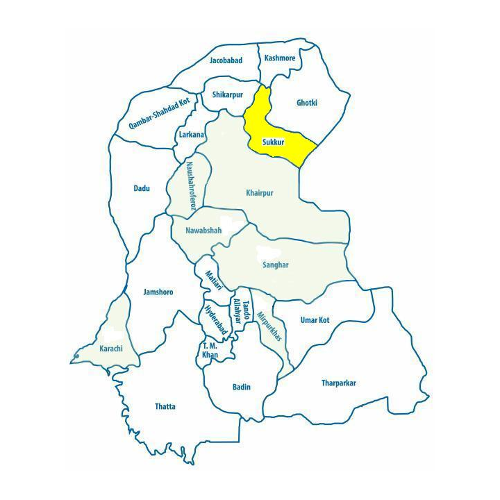
Map of Sindh
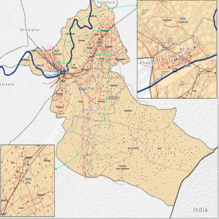
Map of Sukkhur District
Sindh Districts
- Karachi District Profile
- Badin District Profile
- Dadu District Profile
- Ghotki District Profile
- Hyderabad District Profile
- Jacobabad District Profile
- Jamshoro District Profile
- Kashmore District Profile
- Khairpur District Profile
- Larkana District Profile
- Matiari District Profile
- Mirpurkhas District Profile
- Naushero FerozeDistrict Profile
- Sanghar District Profile
- Shahdadkot District Profile
- Shaheed Benazirabad District Profile
- Shikarpur District Profile
- Sukkhur District Profile
- Tando AllahYar District Profile
- Tando Mohammad Khan District Profile
- Tharparkar District Profile
- Thatta-Sajawal District Profile
- Umerkot District Profile
Also visit: Punjab, Balochistan, Khyber Pakhtunkhwa
Sukkur District Profile
Introduction/Geographical Location; Sukkur District
Sukkur district is located between 27° 04” 0Ꞌ to 28° 02” 15Ꞌ North latitudes and 68° 35” 30Ꞌ to 69° 48” 0Ꞌ East longitudes. This district is bounded by district Ghotki and India on the East, district Kashmore on the North, district Shikarpur on the Northwest, and district Khairpur on the West and South. Indus River flows on the northwestern side of this district.
Sukkur District at a Glance
| Name of District | Sukkur District | |
| District Headquarter | Sukkur City | |
| Population[1] | 1,488,000 persons | |
| Area[2] | 5,165 km2 | |
| Population Density | 288 persons/ km2 | |
| Population Growth Rate[3] | 2.5 % | |
| Male Population[4] | 52.1% | |
| Female Population[5] | 47.9% | |
| Urban Population[6] | 48.3% | |
| Tehsils |
5 Talukas: 1. Sukkur City Taluka 2. New Sukkur Taluka 3. Saleh Pat Taluka 4. Rohri Taluka 5. Pano Aqil Taluka |
|
| Main Towns | Rohri (or Aror/Alor), Bukkur Island, Sadh Belo, Sukkur, Shamsabad, Gharibabad, Old Sukkur, Saleh Pat, Pano Aqil, Baiji Sharif, Kandhra, Hingoro, Rahuja, and Nauraja | |
| Literacy Rate[7] | 60% | |
| Male Literacy Rate[8] | 76% | |
| Female Literacy Rate[9] | 42% | |
| Major Economic Activity[10] | Elementary Occupations | 33.4% |
| Agriculture with its allied Livestock breeding & Fishing | 29.4% | |
| Activities not adequately defined | 20.2% | |
| Others | 17% | |
| Main Crops | Rice, wheat, jowar, bajra, maize, gram, barley, rapeseed & mustard, sesanum, sugarcane, cotton, tobacco, moong, maash, arhar, masoor, gram, tobacco, groundnut, sugarbeet, guar seed, linseed, and sunflower | |
| Major Fruits | Banana, dates, mango, watermelon, musk melon, citrus, ber, and mulberry | |
| Major Vegetables | Peas, onions, potatoes, okra, tinda, brinjal, bitter gourd, luffa, cucumber, long melon, field vetch, lotus roots, turnip, carrot, spinach, tomatoes, cauliflower, sweet potatoes, radish, fenugreek, chilies, spearmint, garlic, and coriander | |
| Forests (Area)[11] | 32,577 HA[12] | |
| Total Metalled Road[13] | 894 km | |
| Shingle Roads[14] | Nil | |
| No. of Grid Stations[15] | 5 grid stations, with 4 of capacity of 132 KV and one of 66 KV | |
| No. of Tel. Exchanges | Data not available but due to optical fiber cable network, telephone connections are easily available | |
| Industrial Zones and Industrial Units[16] |
There are 3 Industrial Estates in the district: · Sukkur Industrial Trading Estate (SITE): 1,054 Units · Rohri Industrial Estate · Small Industries Estate (SIE): 150 Units |
|
| Major Industry[17] |
Ghee, oil, biscuits, soap, beverages, flour, straw paper board, poultry farm, dates processing, sulphuric acid, ice, and cold storage, cotton textiles, cement, leather, tobacco, paint and varnish, pharmaceuticals, agricultural implements, hand pumps, lock making, rice-husking, and sugar. Small-scale cottage industries include hosiery, boat making, fishing accessories, thread-ball spooling, trunk making, brass-wares, cutlery, and ceramics |
|
| Household Size[18] | 6.6 persons per house | |
| Houses (Piped Water Inside)[19] | 37.7% | |
| Houses with Electricity[20] | 73.5% | |
Table 1.1 Sukkur District at a Glance
[1] 2017 Census
[2] 1998 Census.
[3] 2017 Census
[4] 2017 Census
[5] 2017 Census
[6] 2017 Census
[7] Pakistan Social & Living Measurement Survey 2014-15 (PSLM); Latest available
[8] PSLM
[9] PSLM
[10] 1998 Census; 2017 Census Data has not been made public yet.
[11] Sindh Development Statistics 2017-18
[12] Land Utilization Statistics of the same document marks 35000 HA as Forest area.
[13] Sindh Development Statistics 2017-18
[14] Sindh Development Statistics 2017-18
[15] Environmental & Social Assessment for HESCO by Elan Partners Ltd, 2007. Latest available.
[16] Sukkur District Profile by Small, Medium Enterprise Development Authority (SMEDA)
[17] Sukkur District Profile by SMEDA
[18] 1998 Census; 2017 Census Data has not been made public yet.
[19] 1998 Census; 2017 Census Data has not been made public yet.
[20] 1998 Census; 2017 Census Data has not been made public yet.
Brief History – Governmental Structure – Administrative Divisions – Protected Heritage/ Historical Buildings
Brief History; Sukkur district
Sukkur occupies an important position not only in the history of Sindh, but also in the ancient history of South Asia. Located on the west bank of the River Indus, Sukkur has consistently functioned as an important strategic trading route. The ancient records show that during the invasion of Sindh by Alexander the Great in 326 BC, Sindh was ruled by the Musikanos[1], whose capital was Alor (Aror), a city 8 km East of Rohri. Musikanos paid tribute to Alexander the Great, and thus, retained his chiefdom.
Soon after Alexander’s departure from the region, Buddhism, Jainism, and Brahmanism became the predominant religions practiced in the region, with followers of Brahmanism and Buddhism vying for social and political control of the region. The Rai Dynasty, one of the Brahmin dynasties, in fact, ruled Sindh including the areas now part of Sukkur district, extending to an area equivalent to 1,553,993 km2. This dynasty ruled for 137 years. According to Chachnama[2] (or Fatehnama Sindh), the last Rai Emperor, Rai Sihasi II, died of illness without a child to succeed him, leaving the throne open to dispute. Chach, a Brahmin and a minister in Sihasi’s court, married the widowed queen, usurping the throne and laying the foundations for what became known as the Chach[3] Dynasty (another Brahmin Dynasty). He ruled for 40 years, succeeded by his brother Chander, who, in turn, was succeeded by his nephew Dahir, the eldest son of Chach. During Raja Dahir’s reign, Muhammad Bin Qasim attacked Sindh (711 AD) who, after conquering Sehwan and Brahmanabad (Hyderabad district), took possession of Alor.
Sindh continued to be ruled by Arabs—first by the Umayyad Caliphate and then the Abbasis. By 908 AD, the power of the Arab Caliphs waned, leading to renunciation of their control of Sindh.
In 1026 AD, Mahmood of Ghazni captured Multan and sent his vizier, Abdul Razzak, to attack Sindh. He took Sehwan, Thatta, and the rest of Sindh. According to Imperial Gazetteer of India (v.23, p. 120), the area eventually passed to the Soomra Dynasty (1024-1351 AD), then Samma Dynasty (1335-1520 AD) and finally to the Arghun Rulers of Sindh (15th century to early 16th century).
The Imperial Gazetteer of India (v. 23, p.120) shows that the region changed many hands during the 16th and 17th centuries:
Under the Emperors of Delhi a Sindhi tribe the Mahars [also spelled Mehrs] asserted themselves by driving out the Jatoi tribe of Baloch who were settled on the west bank of Indus, but were themselves displaced a few years later by the powerful Daudputras [also spelled as Daudpotas], another Sindhi tribe who, led on by their Pir, Sultan Ibrahim Shah, inflicted a severe defeat on the Mahars [or Mehrs] sacked their town of Lakhi, and founded a new capital of Sindh at Shikarpur. In the eighteenth century the Kalhora chiefs held sway over the Upper Sindh Districts, till the Afghan invasion of 1781. Between 1809 and 1824, their successors the Talpur Mirs recovered Burdika, Rupar and Sukkur from the Durrani Kingdom, and finally captured Shikarpur, in time to prevent the town falling into the hands of the Sikhs under General Ventura. In 1833, during the Talpur Rule, Shah Shuja, the dethroned Afghanistan monarch, made an expedition into Upper Sindh to recover his lost territory. He marched with a force via Bahawalpur towards Shikarpur and gained a victory, which resulted in paying of a tribute by the Talpurs. The Shah subsequently, marched on his expedition against Kandahar but; [sic] being defeated by Dost Muhammad, he retreated to Sindh and proceeded to Hyderabad, where he received enough money from the Mirs that enabled him to return to Ludhiana in the Punjab.
In exchange for monetary assistance, Shah Shuja signed a treaty with the Talpur rulers, under the terms of which he relinquished all claims on Sindh. In 1843, the British (led by General Charles James Napier) defeated the Talpurs at the battle of Miani and Dubbo near Hyderabad, and ruled Sindh (including Sukkur) until the independence of Pakistan. After the annexation of Sindh, Sir Charles Napier was appointed Governor of the Province, and he made Karachi his headquarters.
While describing this period in Sindh’s history, Imperial Gazetteer of India (v. 23, p. 120, 121) further states:
In 1843 on the conquest of the Province, all Northern Sindh with the exception of that portion held by the Khairpur Mirs, Ali Murad Talpur, was formed into Shikarpur Collectorate and the Frontier District. In 1842, the towns of Sukkur, Bukkur and Rohri had by treaty been ceded to the British in perpetuity. In 1851 Mir Ali Murad Talpur, of Khairpur, was after a full and public inquiry, convicted of acts of forgery and fraud, in unlawfully retaining certain lands and territories which belonged by rights to the British Government. The forgery consisted in his having destroyed a leaf of Quran in which the Naunahar Treaty, concluded in 1842 between himself and his brothers Mirs Nasir and Mubarak Khan was written, and having substituted for it another leaf in which the word ‘village’ was altered to ‘District’, by which he fraudulently obtained possession of several large Districts instead of villages of the same name. In January 1852, the Governor-General of India (the Marquise of Dalhousie) issued a proclamation depriving the Mir of the tracts wrongfully retained and degrading from him the rank of “Rais” (or Lord Paramount). Of the areas so confiscated, Ubauro, Buldika, Mirpur, Saidabad and other parts of Upper Sindh on the left bank of Indus, now forming greater part of Rohri sub-division, were added to Shikarpur District, which in 1901 was divided into Sukkur and new district of Larkana.
Until 1901, Sukkur formed part of Shikarpur district, which consisted of 14 Talukas. 7 Talukas were then detached to form the district of Larkana, and the name of the remaining district was changed from Shikarpur to Sukkur.
Sukkur saw a significant socio-economic uplift in 1932, when the British Raj built the Sukkur Barrage/ Lloyd Barrage on the Indus River (the Sukkur Barrage). The Lansdowne Railway Bridge over River Indus in Rohri was built in 1879. Before this bridge was built, the Indus Steam Flotilla ferry[4] system was used to travel from one bank to the other. The railway bridge made the use of the Indus Steam Flotilla ferry system redundant. The bridge provided the railway link between Lahore, in the heart of the granary of British India, and the port of Karachi on the Arabian Sea. When the great steel Ayub Arch was constructed (1960–1962), railway traffic was shifted to that bridge. About a hundred feet apart, the two bridges seem like one from a distance. The Ayub Arch became the world’s third longest railway arch span and the first bridge in the world to construct a suspended railway deck supported mainly by coiled wire rope suspenders.
The name Sukkur is a derivative of the word Saqar which means hot in Arabic, a name used by the Arab conquerors for the region when they first arrived and found the climate to be very hot. The name evolved into Sukkur over time.
The original Sukkur district has been bifurcated into 3 districts: Sukkur, Shikarpur, and Ghotki. Sukkur was divided into Sukkur and Shikarpur districts in 1977, and Ghotki district was created in 1993.
Figure 1.3 Landsdowne & Ayub bridges stand side by side, straddling the Indus to connect Sukkur and Rohri
Governmental Structure; Sukkur district
At the Federal level, Sukkur district is allocated a set number of representatives in both the National Assembly and the Provincial Assembly:
- Number of seats in the National Assembly 2
- Number of seats in the Provincial Assembly 4
The district has 1 Municipal Corporation (Sukkur) and 1 Municipal Committee (Rohri).
It has 4 Town Committees:
- Bagarjai
- Kandhra
- Pani Akil
- Salehpat
Administrative Divisions; Sukkur district
Sukkur district has 5 Tehsils:
| Sukkur City Tehsil | 11 Union Councils |
| New Sukkur Tehsil | 09 Union Councils |
| Pano Aquil Tehsil | 12 Union Councils |
| Rohri Tehsil | 11 Union Councils |
| Saleh Pat | 03 Union Councils |
Table 1.2 Sukkur Administrative Divisions
Heritage/ Historical Buildings/Recreation Areas; Sukkur district
There are 5 heritage/ historical sites in Sukkur protected under the Government of Pakistan Laws. These are:
- Mir Masum’s Minar and Tomb, Sukkur
- Sateen Jo Aasthan (Tomb of the Seven Maidens), Rohri, Sukkur. Made of enameled tiles, these tombs are dated between 1609 and 1883 AD. The principal grave is that of Mir Kasim Shah, one of the Sabzwari Shahids. The tomb was constructed around 1018 AD. This was probably the grave that sanctified the site. The name of Than Kasim Shah Hill is ascribed to him
- Bukkur Fort/Island; Sukkur district. This is an island made up of limestone in a roughly oval shape. The area of the fort includes the walls and tomb of Hazrat Sadruddin Muhammad, and is located between Lansdowne and Sukkur Bridges. It is occupied by the Army Public School and the mausoleum
- Stone Tool Factory Area, Rohri, ; Sukkur district
- Wooden Carved door on the building owned by Evacuee Trust Property Board; Sukkur district
Some of the important (unprotected) historical sites of the area include:
- Sukkur Barrage or Lloyd Barrage constructed by the British in 1932
- Lansdowne Railway Bridge and Ayub Railway Bridge; Sukkur district: Lansdowne Bridge was constructed by the British and, though still standing, is no longer considered structurally safe. Ayub Bridge was constructed in 1962 to replace the Lansdowne Bridge
- Ruins of the historical city Alor in Rohri; Sukkur district
- Bukkur Island with its historical fort, opposite Ayub Bridge; Sukkur district: The island consists of a rock of limestone, 244 meters long, and 92 meters wide. To the West of it are 2 small river islets called Sadh Bela and Din Bela. The island was converted into a fort in 1964
- Sadh Belo or Sat Belo, a Hindu temple on Bukkur Island; Sukkur district
- Jamia Masjid, Bunder Road, Sukkur
- Tomb of Abdul Baqi, ex-Governor, Bukkur Island; Sukkur district
- Tomb of Mian Adam Shah Kalhoro: located on Shah Ji Takri Hill (of Adam Shah), Sukkur. The tomb was built in 1768 AD by Mian Ghulam Shah Kalhoro, a ruler of Sindh
- Minaret of Masoom Shah, Sukkur: Masoom Shah is well known for writing the history of Sindh called Tarikh-e-Sind. He was also a general in Mughal Emperor Akbar’s army. His minaret is the most conspicuous structure of Sukkur town, dating back to 1607, during theMughal Empire period of the subcontinent located in Sukkur district
- Lab-e- Mehran: a famous garden located on the bank of River Indus in Sukkur
- Rohri Hills; Sukkur district: These hills extend in a North‒South direction between the Indus and the cities of Sukkur and Rohri. These Hills consist of limestone and flint. The flint was used in the manufacture of the parallel-sided blades used by the Harappan culture of 2300-1750 BC
- Tomb of Shah Khairuddin Jilani, Sukkur: He lived and settled in Sukkur, where he remained until his death in 1617; one of his successors, Mian Ghulam Mohammad built the mausoleum in 1670
- Tomb of Syed Rashid Shah Pir Pagaro, Pir Goth; Sukkur district
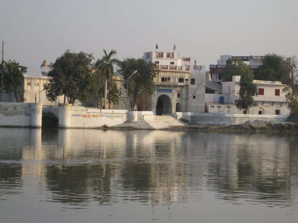
Figure 1.4 Sadh Belo Temple
![]()
Figure 1.5 Minaret of Masoom Shah
[1] Musikanos was the Chief of Mohen jo Daro State at that time.
[2] Chachnama is one of the main historical records of Sindh, and chronicles, in its 1st chapter, the Rai Dynasty and the Chach Dynasty, which was established after the fall of the Rai Dynasty.
[3] Brahmanism and Brahminism are different; the former is the religion that developed out of the Vedic Religion, and Brahminism is the ritualistic system led by the Brahmins.
[4] Indus Steam Flotilla was a freight and passenger steamship company that initially ran ferries between Karachi and Multan, and later, between Kotri and Multan (after the completion of the Karachi‒Kotri Railway Line), between 1858 and 1870.
Topography; Sukkur district
Topographically[1], the district may be divided into 2 broad parts: a plain cultivated area in the western half and a desert in the eastern half.
The western half of the district forms a vast alluvial plain, broken only at Sukkur and Rohri by low limestone hills, which tend to preserve a permanent bank for the Indus at those places. The Indus once flowed past these hills near the ancient town of Alor and was diverted into its present channel through the Bukkur hills by a natural convulsion. Large patches of salt land (Kalar) occur frequently, especially in the upper part of the district.
The eastern part of the district—which consists of a part of Taluka Rohri, and Saleh Pat—forms part of the great Nara Desert, and is known as Registan. It possesses extensive sand hills.
A small limestone range in the Southwest of Rohri Taluka runs from near Rohri town, due North and South, into Khairpur. These hills extend for 45 km into the district, spreading out to a width of 27 km. Their highest elevation is about 24 m above mean sea level. They are nummulitic limestone and belong to the same group as the Khairpur Range, which they resemble in their rugged and barren aspect. There are 4 prominent hills: Adam Shah Hill near Sukkur, Kalka Hill at Aror, Laheri Hill at Rohri, and Shadi Shaheed Hill at Kandhra.
The city of Sukkur is located at an altitude of 67 m (220 feet) from sea level; it is also the narrowest point of the lower Indus course.
Rivers, Streams, and Lakes; Sukkur district
Indus is the only river which passes through the northwestern border of Sukkur district. At Sukkur, it passes through the gorge between Sukkur and Rohri towns, with the island of Bukkur bisecting the channel. The district gets it water supply from the River Indus and various canals and water channels in the district.
There are a number of old river courses in the district like Raini River course and Mir Wah course. These water courses are now used as irrigation canals. A number of lakes occupy the beds of these rivers and canals during canal water closures.
Forests; Sukkur district
Most of the forests in Sukkur district are riverine forests that grow along the banks of River Indus. As per Sindh Development Statistics 2012-13, the total forested area is 35,000 HA. Some of the forests of the district include: Bindi Dhareja, Keti-abad, Khia Bindi, Qadirpur, Ding, Keti Shah, Panwhari, Azizpur, Keti Shahu, Keti-abad-II, Changri, Katha, Rohri, Sadhuja, Khan Belo, Budh, Wahidpur, Bahab, S.K. Shahu, Sunderani, Old Gublo, Gondak, Rounti, and Wasti. Of these, the Rounti and Gondak are classified as rangelands.
The main flora of these forests includes babul (Acacia nilotica), bahan or euphrates poplar (Populus euphratica), athel pine or farash (Tamarix aphylla), lai or salt cedar (Tamarix dioca) and kandi (Prosopis cineraria).
The Forestry Statistics section of the Sindh Development Statistics 2012-13 reports zero area under forests.
Soils; Sukkur district
Indus alluvium occupies most of Sukkur district which is specified/ differentiated as follows:
- Latiari: a soil formed from the silt of inundation
- Tanak: the hard soil left by repeated inundations
- Thariari: a crooked[2] soil often seen near the river with great cracks
- Gesari: a dusty soil
- Rabba and khariri: hollow and uneven soil
- Pat: fertile soil
- Kalar: saline soil
- Thatth kallar: very salty soil
Climate; Sukkur district
The climate[3] of the district is hot and dry, with an absence of air currents during the inundation season. The hot season starts in April and ends in October. The network of canals and the district’s proximity to the River Indus adds humidity, making the summers even more intense. Dust storms are frequent, and fierce, hot winds blow. A cool breeze blows at night during the summers, bringing some respite from the hot temperatures of the days. After October, the temperatures begin to fall. June is the hottest month, with mean maximum and minimum temperatures at 44 ⁰C and 29 ⁰C respectively. Winter months are December, January, and February which are quite cold. The mean maximum and minimum temperatures during January (the coldest month) are 23 °C and 9 °C.
Very little precipitation is received during the summer months. July and August are the Monsoon or rainy months, when the district gets most of its annual rainfall. The average annual rainfall is 88 mm.
Seismic Activity/Seismicity; Sukkur district
The district falls under Zone 2 A of the Pakistan Seismic Zone Map[4] which means that there will be moderate to low damage by earthquakes.
[1] Sukkur District Profile by GoPakistan, 1998, and Imperial Gazetteer of India v.23 p.119 Sukkur District
[2] Crooked soils are poorly drained soils found in depressions formed in mixed alluvium
[3] Sukkur District Profile by GoPakistan 1998
[4] Please see map included in Pakistan chapter
Population; Sukkur district
The following table shows the population of Sukkur district as per 2017 Census:
| District/Taluka | Area km2 | Population | Male% | Female% | Urban% | Growth Rate % |
| Sukkur District | 5,165 | 1,487,903 | 52.1 | 47.9 | 48.4 | 2.9 |
| Pano Aqil Taluka | 1,233 | 435,823 | ||||
| Rohri Taluka | – | 371,104 | ||||
| Saleh Pat Taluka | – | 129,619 | ||||
| Sukkur City Taluka | 274 | 231,589 | ||||
| New Sukkur Taluka | 319,768 |
Table 1.3 Sukkur Population Statistics
Religions; Sukkur district[1]
| Islam | 96.1% |
| Christian | 0.5% |
| Hindus | 3.2% |
| Ahmadi | Negligible % |
| Scheduled Caste | 0.1% |
| Others | Negligible % |
Table 1.4 Sukkur Religions
Languages; Sukkur district[2]
| Sindhi | 74.1% |
| Urdu | 13.8% |
| Punjabi | 6.6% |
| Pashto | 1.5% |
| Balochi | 1.5% |
| Seraiki | 1% |
| Others[3] | 1.5% |
Table 1.5 Sukkur Languages
[1] 1998 Census; 2017 Census Data has not been made public yet.
[2] 1998 Census; 2017 Census Data has not been made public yet.
[3] Mainly Memoni, Marwari, Bihari, Brahvi, Kachhi, and Gujarati
Economic Activity – Economic Infrastructure
Economic Activity; Sukkur district
The major economic activities[1] of the district are:
- Elementary Occupations (33.4%)
- Agriculture with its allied Livestock Breeding & Fishing (29.4%)
- Activities not adequately defined (20.2%)
- Others (17%)
Land Use; Sukkur district
The following table shows the main land use statistics for Sukkur district as per Sindh Development Statistics 2017-18:
| Land Use | Area | Land Use | Area |
| Total Area | 480,000 HA | Reported Area | 480,000 HA |
| Cultivated Area | 163,000 HA | Net Sown | 71,000 HA |
| Current Fallows | 92,000 HA | Uncultivated Area | 317,000 HA |
| Forest Area | 35,000 HA | Culturable Waste | 164,000 HA |
Table 1.6 Sukkur Land Use Statistics
Irrigation Network; Sukkur district
The irrigation system of the district is controlled by the Guddu Barrage and the Sukkur Barrage. Cultivation depends upon river spill water, inundation canals, and tube wells. The Rohri Canal, Nara Canal, Dadu Canal, Rice Canal, and Khairpur Feeder West are the main canals irrigating the district.
The following table shows the modes of irrigation and area irrigated by each mode as per Sindh Development Statistics 2017-18:
| Mode of Irrigation | Area | Mode of Irrigation | Area |
| Total Irrigated Area | 61,058 HA | Un-Irrigated Area | 9,997 HA |
| Canal Irrigated | 49,636 HA | Wells Irrigated | – HA |
| Tube Well Irrigated Area | 11,422 HA |
Table 1.9 Sukkur Irrigation Statistics
Agriculture; Sukkur district
The district belongs to the Southern Irrigated Plains Agro-Ecological Zone of Pakistan. Important crops of the district include rice, wheat, jowar, bajra, maize, gram, barley, rapeseed & mustard, sesanum, sugarcane, cotton, tobacco, moong, maash, arhar, masoor, gram, tobacco, groundnut, sugarbeet, guar seed, linseed, and sunflower.
Fruits grown in the district include bananas, dates, mango, watermelon, musk melon, citrus, ber, and mulberry.
Vegetables grown in the district include peas, onions, potatoes, okra, tinda, brinjal, bitter gourd, luffa, cucumber, long melon, field vetch, lotus roots, turnip, carrot, spinach, tomatoes, cauliflower, sweet potatoes, radish, fenugreek, chilies, spearmint, garlic, coriander, and fodder.
Livestock Breeding; Sukkur district
The livestock mostly consists of sheep, goats, cattle, donkeys, camels, and horses. These animals play a vital role in the economy of the district and provide food of rich nutritional value such as milk and meat, by-products such as butter, oil, cheese, curd, skin/hides and intestines. Sheep provide wool. Bullocks and camels are kept for farming as well as for nutritional purposes. Total livestock population in the district as per 2006 Livestock Census data (latest available) and as recorded in Sindh Development Statistics 2017-18 is as follows:
| Cattle | 212,000 Heads | Buffaloes | 196,000 Heads |
| Sheep | 47,000 Heads | Goats | 250,000 Heads |
| Camels | 8,000 Heads | Horses | 1,000 Heads |
| Asses | 10,000 Heads | Mules | 1,000 Heads |
Table 1.7 Sukkur Livestock Statistics
The local breeds of livestock include Sindhi desi goats, barbary goats, kooka sheep, and kachhi camels.
Poultry Farms; Sukkur district
In rural areas, poultry in small numbers is bred in houses by women for eggs and meat. Most of the commercial poultry farms are located around urban centers. There are 146 poultry farms[1] in the district.
Fishing; Sukkur district
Inland fishing is carried out on a large scale in Sukkur district. Specifically, it is carried out in canals, especially in the deep pools that are left standing during a canal closure. There are no fishing towns, but fishermen of the Jhaber or Mohana classes depend exclusively on their earnings from fishing. They live in villages, like Miani, scattered around the river. The main types of fish indigenous to the region are Palla, Dambhro, Mori, Muli or Poiki, Morakhi or Morakho, and Thelli.
Minerals and Mining; Sukkur district
The district is not rich in minerals. Salt and saltpeter are the 2 minerals found in the district. There are 2 stone quarries in Sukkur and Rohri Talukas. The stone from the quarry in Sukkur is used in the construction of roads.
Oil and gas are also being mined in Sukkur, with the first oil and gas well having been dug in 1893. Larger gas reserves have recently been discovered in the district.
Manufacturing/Industry; Sukkur district
There are 3 Industrial Estates[1] in Sukkur district: the SITE, the Small Industries Estate (SIE) Sukkur and SIE Rohri. SITE has 1,054 units producing various items, of which 1,035 units are closed/ sick. The SIE Sukkur houses 150 units of which 45 are sick/ closed. The SIE Rohri houses 1 unit.
Current industries include the production of ghee, oil, biscuits, soap, beverages, flour, straw paper board, dates (processing), sulphuric acid, ice and cold storage, cotton textiles, cement, leather, tobacco, paint and varnish, pharmaceuticals, agriculture implements, hand pumps, lock making, rice-husking, and sugar.
Following table gives the type and number of industries in the District as per the official website of National Vocational & Technical Education Pakistan[2]:
| Industry | No. of Units | Industry | No. of Units |
| Daal Processing Mills | 10 | Cotton Ginning | 51 |
| Ice Factories | 26 | Rice Husking | 157 |
| Flour Mills | 16 | Food & Beverages | 02 |
| Biscuit Manufacturing | 03 | Confectionary | 03 |
| Sugar Mills | 03 | Chemicals | 01 |
| Lubricants | 01 | Fertilizer | 01 |
| Oil & Ghee Mills | 04 |
Handicrafts; Sukkur district
Small-scale cottage industries comprise hosiery, boat making, fishing accessories, thread-ball spooling, trunk making, brass-wares, cutlery, ceramics, and ajrak making.
Economic Infrastructure; Sukkur district
The main means of transport and communication in Sukkur district are roads and railways. All Taluka headquarters are connected with district headquarters by rail or black topped roads. Sukkur is also connected by air with Karachi and other cities. There is a small-scale industry focused on the movement of goods by steamer and boat, notably between Sukkur and Rohri.
Road Statistics; Sukkur district
The following table shows the road statistics as provided in the Road List 2009 issued by the Sindh Government (latest available):
| Provincial Highways | 46.2 km |
| Access Roads | 308 km |
| Secondary Roads | 301 km |
Table 1.8 Sukkur Roads Statistics
According to the Sindh Development Statistics 2017-18, there are a total of 894 km of black topped roads in the district.
The National Highway N-5 passes through Sukkur district. Another national highway, the N-65, also passes through the district and connects it to Quetta. This highway starts at Sukkur city. The second largest national highway of Pakistan, the Indus Highway N-55, passes very close to Sukkur town. Some of the important roads in Sukkur district are:
- Road from Sukkur to Jacobabad via Shikarpur
- Road from Sukkur to Sadiqabad (Punjab) via Rohri, Pano Akil, Ghotki, Mirpur Mathelo, and Ubauro
- Road from Sukkur to Khairpur
- Road from Sukkur to Shadishaheed (Khairpur) via Laung Faqir
- Road from Pano Akil to Khanpur via Sultanpur, Thekartho, and Shahpur
Rail and Airways; Sukkur district
There is a domestic airport at Sukkur city, which hosts flights to the larger international airports.
Along with the main Railway Stations at Sukkur city and Rohri city, there are other smaller railway stations, including one at Pano Aqil.
Radio and Television; Sukkur district
There is no television station in Sukkur district, but TV can be viewed through boosters and cable can be viewed in the district. There is an FM radio station in Sukkur city called Hum FM 106.2.
Telecommunications; Sukkur district
Sukkur is a modern city with telecommunication services easily available. Pakistan Telecommunication Corporation (PTCL) has exchanges in all Taluka headquarters and the district is linked with other parts of Pakistan and the world through PTCL lines, as well as through most of the mobile phone companies, which are operating in the district.
Post Offices/ Courier Services; Sukkur district
Pakistan Post Office has its offices in all Taluka headquarters with Urgent Mail Service (UMS) also easily available. There are 25 offices[1] of Pakistan Post in the district. The GPO at Sukkur city has a night office as well.
Banking/ Financial Institutions; Sukkur district
Most of the national banks of Pakistan and some private banks have their branches in all talukas of the district. Major banks that operate[2] in the district include:
- Al-Baraka Bank Ltd.
- Askari Bank Ltd.
- Allied Bank
- Bank Alfalah
- Bank Al Habib
- Bank Islami Ltd.
- Burj Bank Ltd.
- Dubai Islamic Bank Pakistan Ltd.
- Faisal Bank Ltd.
- Habib Bank Ltd.
- First Women Bank Ltd.
- Habib Metropolitan Bank Ltd.
- KASB Bank
- Muslim Commercial Bank
- National Bank of Pakistan
- National Investment Bank of Pakistan
- Silk Bank Ltd.
- Sindh Bank Ltd.
- Soneri Bank Ltd.
- Summit Bank Ltd.
- The Bank of Punjab
- United Bank Ltd.
- Zarai Taraqiati Bank Ltd.
In all there are 82 branches of conventional banks and 15 branches of Islamic banks in te District.
Electricity and Gas; Sukkur district
The district gets its electricity through the national grid. Hyderabad Electric Supply Corporation is responsible for providing electricity to Sukkur district. There are a total of 3 grid stations, with one of 66 KV and 2 grid stations of capacity 132 KV (each) in the district.
Natural gas connections for domestic purposes are available in the urban areas of the district.
Educational Institutions; Sukkur district
Literacy rate of Sukkur district is 60% with 76% males and 42% female population considered literate.
The following table shows the number of educational institutions in the district as per Sindh Development Statistics 2017-18:
| Institution | Boys/Girls | Institution | Boys/Girls |
| Primary Schools | 919/108 | Middle Schools | 64/18 |
| High School | 59/19 | Higher Secondary | -/- |
| Degree College | 03/02 | Post Graduate College | 02/- |
| Technical Colleges | 02/01 | Commercial Schools | 02/- |
| Vocational Institutes | 02/05 | Cadet Colleges | 01 |
| Medical University[1] | 01 | Engineering Colleges | 01 |
| Universities[2] | 01 |
Table 1.10 Sukkur Educational Institutes
Healthcare Facilities; Sukkur district
The following table shows the Government Health Care Institutions in Sukkur district as per Health Profile Sindh District 2017-18:
| Institution | No./Beds | Institution | No./Beds |
| Teaching Hospital | 01/330 | Major Hospitals | 02/61 |
| Government Hospitals | 07/301 | Dispensaries | 43/12 |
| Rural Health Centers | 05/54 | Basic Health Units | 26/52 |
| T B Clinics | 06/- | Mother Child Health Centers | 04/32 |
| Private Hospitals | 13/558 | Private TB Clinics | -/- |
| Private Dispensaries | 34/- | Private MCHC | 02/- |
Table 1.11 Sukkur Health Institutes
In addition, there is 01 Leprosy clinic, 06 Maternity Homes, 01 Unani Shifa Khana and 01 Urban Health Unit.
Policing; Sukkur district
Sindh Police Department is headed by the Provincial Police Officer who controls 6 AIGP (Additional Inspector General Police; one each of Sindh, Investigations, Special Branch, Karachi, Hyderabad, and Regional Police Officer Sukkur). AIGP RPO (Regional Police Officer) Sukkur is in charge of the entire Police Department of Sukkur and Larkana. The DIG (Deputy Inspector General-Operations) Sukkur and Larkana report directly to AIGP RPO Sukkur. District Police Officer (DPO) Sukkur is in charge of the district.
In all, there are 29 Police stations[3] in the district.
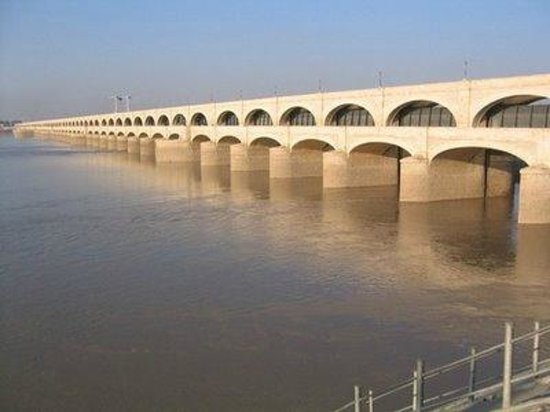
Figure 1.6 Sukkur Barrage
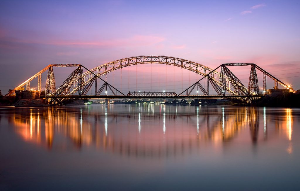
Figure 1.7 Lansdowne Bridge Sukkur
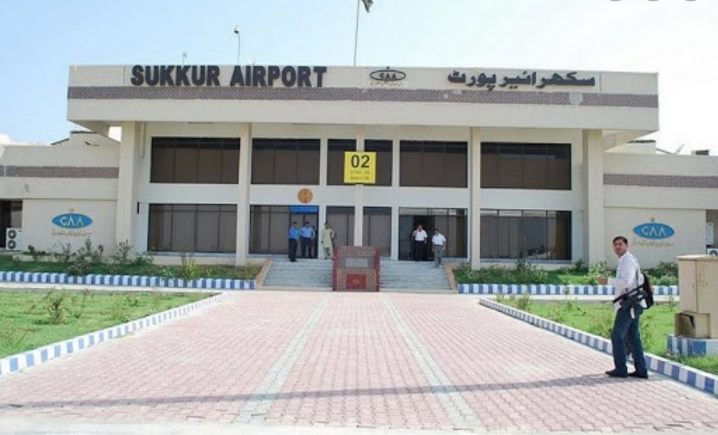
Figure 1.8 Sukkur Airport
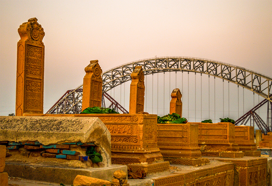
Figure 1.9 Sateen Jo Aasthan (Tomb of the Seven Maidens), Rohri, Sukkur
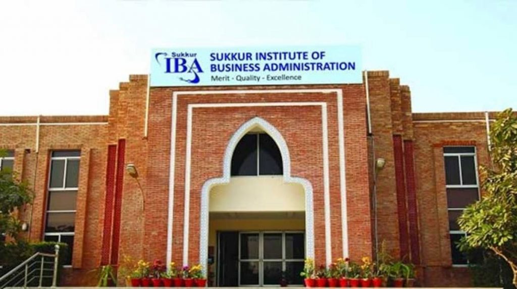
Figure 1.10 IBA Sukkur Campus
[1] Ghulam Muhammad Mehar Medical College, Sukkur
[2] Institute of Business Administration Sukkur Campus. This campus awards degrees in Electrical Engineering and Business Administration
[3] Official Website Sindh Police
[1] Official Website Pakistan Post
[2] List of Reporting Bank Branches 2019, State Bank of Pakistan.
[1] Sukkur District Profile by SMEDA
[2] http://www.skillingpakistan.org/employer/province/9/district/63
[1] Table 17 Number of Commercial Poultry Farms and Number of Birds by Size of Flock
[1] 1998 Census; 2017 Census Data has not been made public yet.
Environment and Biodiversity; Sukkur District
Sukkur district belongs to the rich Indus eco-region. The Indus eco-region is characterized by diverse habitat types consisting of coastal, freshwater, and brackish wetlands, riverine forests, a vast desert, and irrigated plains. The main Indus River course is the habitat of the Blind Indus Dolphin. Moreover, a variety of fish species including Indus baril, Indus garua, and the golden mahasheer are found in the river.
Generally, the district is free from air pollution, with the major air quality issue being suspended dust particles.
Flora and Fauna; Sukkur District
Flora
The flora of Sukkur district is characteristic of the rainless climate, dry atmosphere, and sandy soil. Most of the plants have small leaves or none at all, like the milk bush and cactus. A large variety of grasses grow in the district.
Some of the flora of the district include shisham (Dalbergia sissoo), babul (Acacia nilotica), ber (Zizyphus numularia), toot or mulberry (Morus alba), kikri or baonli (Acacia jacquemontii), neem (Azadirachta indica), peelu (Salvadora oleoides), imli or tamarind (Tamarindus indica), ghaz or khagal (Tamarix aphylla), lai or salt cedar (Tamarix dioica), ber (Zizypus numalaria) kandi (Prosopis spicigera), pipal (Ficus religiosa), sarkanda or Bengal cane (Saccharum munja), African fodder cane or wild sugarcane (Saccharum spontaneum), buffle grass or African foxtail grass (Cenchrus ciliarus), camel thorn (Alhagi maurorum), Bermuda grass (Cynodon dactylon), wild jute (Corchorus sp.), ghukro or puncture clover (Tribulus terrestris), and aak (Colotropis procera).
The flora[1] of Nara Desert, a part of the Saleh Pat Taluka, consists of stunted, thorny or prickly shrubs and perennial herbs capable of drought resistance. A large number of herbs found in this region are used for medicinal purposes; some of the herbs found in the region are booh or kapok bush (Aerva javanica), karund or mariro/ trailing amaranth (Amaranthus viridis), tandla or lulur/false amaranth (Digera muricata), lubh (Amberboa ramosa), Arabian primrose or khari (Arnebia hispidissima), naaro or field bindweed (Convolvulus arvensis), trooh or bitter apple (Citrullus colocynthis), rubber bush or Sodom apple (Calotropis procera), and utangan (Blepharis sindica).
Fauna
Hog deer, wild boar, jackals, fox, hare, wolves, porcupines, and hyenas, among others, are found in the riverine forests of the district. Among birds, partridges (both grey and black) are common, as well as water fowl, kunj, large Indian parakeet, white-breasted water hen, cuckoo, and Indian scoop owl, kites, crows, and house sparrows.
In the Nara Desert section of the district, 28 species[2] of mammals, 78 species of birds, and 16 species of reptiles are found.
The mammals of Nara Desert include desert hedgehog, red lynx or caracal, jungle cat, Indian desert jungle cat, Indian and small mongoose, grey wolf, Asiatic jackal, Bengal fox, desert fox, striped hyena, honey badger, scaly anteater, chinkara gazelle, palm squirrel, porcupine, rats, short-tailed mole rat, pygmy gerbil, and Indian desert jirds.
Avifauna of Nara Desert consists of little grebe, grey heron, common teal, mallard, shoveller, red-crested pochard, black-winged kite, Asiatic sparrow-hawk, white-eyed buzzard eagle, Indian white-backed vulture, Egyptian vulture, marsh harrier, short-toed eagle, kestrel, grey partridge, coot, houbara bustard, red-wattled lapwing, Kentish plover, common redshank, common sandpiper, little stint, dunlin, red-necked phalarope, Indian black-winged stilt, ring dove, little brown or Senegal dove, northern spotted owlet, Sindh nightjar, Indian small blue kingfisher, white-breasted kingfisher, blue-cheeked bee-eater, Sindh small green bee-eater, roller or blue jay, Sindh pied woodpecker, black-crowned finch-lark, hoopoe lark, great short-toed lark, Calandra lark, collared sand martin, western swallow, grey shrike, rufous-backed shrike, rosy starling or rosy pastor, Indian myna, tree pie, house crow, raven, Sindh wood shrike, white-eared bulbul, red-vented bulbul, babblers, fly catchers, warblers, chiff chaff, wheat eaters, pied chats, and rock buntings.
Reptiles of Nara Desert include Indian fringe-toed sand lizard, Indian desert monitor, Indian monitor lizard, Indian spiny-tailed lizard, Indian sand swimmer, Sindh sand gecko, Indian garden lizard, black-tailed toed agama, brilliant agama, Afghan ground agama, Indian cobra, Russell’s viper, saw-scaled viper, Indian sand boa, and glossy bellied racer.
Protected Wildlife Areas and Endangered Species; Sukkur District
- Part of Indus Dolphin Reserve (from Sukkur to Guddu Barrage) is in the district. This provides sanctuary to the endangered Blind Indus Dolphin or bulhan
- Part of Nara Desert Wildlife Sanctuary is located in Sukkur district. It provides sanctuary to endangered striped hyenas, jackals, fox, pangolin wolves, jungle cat, caracal (all critically endangered), and Indian wolf, and also to the game birds
- Mando Dero Game Reserve in Rohri is a sanctuary for black and grey partridges and hog deer. There is a carp nursery in this forest, operated by the Department of Forestry, Sukkur
[1] For a complete list, please refer to Ethno-medicinal uses of Herbs From Northern Part of Nara Desert, Pakistan, by Rahmatullah Qureshi, G. Raza Bhatti and Rabia Asma Memon
[2] Bioecology of Nara Desert Wildlife Sanctuary, Districts Ghotki, Sukkur and Khairpur, Sindh, by Syed Ali Ghalib, Abdur Razzaq Khan, Afsheen Zehra And Darakhshan Abbas