Share now
Map of Sindh

Map of Hyderabad District

Sindh Districts
- Karachi District Profile
- Badin District Profile
- Dadu District Profile
- Ghotki District Profile
- Hyderabad District Profile
- Jacobabad District Profile
- Jamshoro District Profile
- Kashmore District Profile
- Khairpur District Profile
- Larkana District Profile
- Matiari District Profile
- Mirpurkhas District Profile
- Naushero FerozeDistrict Profile
- Sanghar District Profile
- Shahdadkot District Profile
- Shaheed Benazirabad District Profile
- Shikarpur District Profile
- Sukkhur District Profile
- Tando AllahYar District Profile
- Tando Mohammad Khan District Profile
- Tharparkar District Profile
- Thatta-Sajawal District Profile
- Umerkot District Profile
Also visit: Punjab, Balochistan, Khyber Pakhtunkhwa
Hyderabad District Profile
Introduction/Geographical Location; Hyderabad District
Hyderabad district is located between 68° 17Ꞌ 26″ to 68° 38Ꞌ 26″ East longitudes and 24° 9Ꞌ 26″ to 25° 33Ꞌ 7″ North latitudes. This district is bounded by Tando Muhammad Khan district on the East as well as the South, Tando Allahyar district on the East, district Matiari on the North, district Jamshoro on the Northwest, and district Thatta on the Southwest. The Indus River flows along the western border of this district.
Hyderabad District at a Glance
| Name of District | Hyderabad District | |
| District Capital | Hyderabad City | |
| Population[1] | 2,199,000 | |
| Area[2] | 996 km2 (only Hyderabad Tehsil) | |
| Population Density | 2207.8 persons/ km2 | |
| Population Growth Rate[3] | 2.05% | |
| Male Population[4] | 52.1% | |
| Female Population[5] | 47.9% | |
| Urban Proportion[6] | 16.7% (Only Hyderabad Tehsil) | |
| Tehsils/Talukas |
4 Talukas: 1. Hyderabad City Taluka 2. Hyderabad Rural Taluka 3. Qasimabad Taluka 4. Latifabad Taluka |
|
| Main Towns | Qasimabad, Old Hyderabad City, Latifabad, Saddar, Hirabad, and Hyderabad Cantonment | |
| Literacy Rate[7] | 59% | |
| Male Literacy Rate[8] | 66% | |
| Female Literacy Rate[9] | 52% | |
| Major Economic Activity[10] | Agriculture, Forestry, Fishing & Hunting | 28.5% |
| Elementary Occupations | 43.6% | |
| Service workers, Shop & Market Sales Workers | 12.9% | |
| Others | 15.0% | |
| Main Crops | Wheat, sugarcane, cotton, rice, gram, jowar, rape and mustard seed, bajra, maize, sesanum, moong, maash, masoor, sugar beet, guar seed, linseed, sunflower, and fodder | |
| Major Fruits | Mango, guava, banana, apples, chikoo, jaamun, watermelon, musk melon, phalsa, citrus, ber, mulberry, papaya, and coconut | |
| Major Vegetables | Tomato, potato, onion, okra, peas, tinda, brinjal, bitter gourd, bottle gourd, pumpkin, luffa, cucumber, long melon, beans, field vetch, turnip, carrots, spinach, cauliflower, cabbage, sweet potatoes, radish, garden peas, fenugreek, lettuce, chilies, spearmint, garlic, coriander, ajwain, and fennel | |
| Forests (Area)[11] | 7,120 HA | |
| Roads (Provincial Highways)[12] | 205 km | |
| Access Roads[13] | 1,269 km | |
| Secondary Roads[14] | 1,937 km | |
| No. of Grid Stations[15] | 2 grid stations; each = 132 KV[16] | |
| No. of Tel. Exchanges | Hyderabad is an urban area with a digitized telephone system | |
| Industrial Zones |
3 industrial zones in Hyderabad district: · Sindh Industrial Trading Estate () · Sindh Small Industries Corporation Industrial Estate (SSIC Industrial Area) · SITE Super Highway |
|
| Major Industry | Glass bangles, soap/ detergent, tobacco, tea, textile, brick kilns, lubricating oil, glazed pottery and tiles, hand woven cloth, cement, leather footwear, gold and silver jewelry, confectionary, corrugated packaging, plastic injection molding (Plastic Bottles, Polyethylene Bags, Plastic containers),furniture (both wood and wrought iron), marble processing plants, handicrafts, and carpets | |
| Household Size[17] | 6 | |
| Houses with Piped Water Inside[18] | 47.3% | |
| Houses with Electricity[19] | 73.6% | |
Table 1.1 Hyderabad District at a Glance
[1] 2017 Census
[2] 1998 Census
[3] 2017 Census
[4] 2017 Census
[5] 2017 Census
[6] 2017 Census
[7] Pakistan Social & Living Measurement Survey 2013-14 (PSLM) latest available; Latest available.
[8] PSLM
[9] PSLM
[10] 1998 Census 2017 Census data has not been made public yet.
[11] Sindh Development Statistics 2017-18; Forestry Statistics
[12] Road List 2009 (Government of Sindh); Latest available
[13] Road List
[14] Road List
[15] Environmental Impact Assessment Hyderabad Electric Supply Corporation (HESCO) 2007; latest available
[16] HESCO supplies electricity to Hyderabad district and Sindh except Karachi.
[17] 1998 Census; 2017 Census data has not been made public yet.
[18] 1998 Census; Census data has not been made public yet.
[18] 1998 Census; Census data has not been made public yet.
[19] 1998 Census; Census data has not been made public yet.
Brief History of Hyderabad District
The history of Hyderabad district is closely related to the history of Sindh. Prior to the arrival of Islam in Sindh with the conquest by Muhammad Bin Qasim, this city was a small fishing village called Neroonkot (meaning place of Neroon, named after its Hindu ruler Neroon) on the banks of River Indus. A nearby hill tract, called the Ganjo Takkar or the Bald (barren) Hill, protected the village from floods of the River Indus, which were a regular hazard in neighboring regions. This hill[1] is a small limestone range of hills and runs due South, parallel to the Indus for about 22.5 km, or 14 miles. This range was also used as a place of worship by the Hindu population.
Muslim armies captured the city, dethroning Neroon, in 711 AD, and, in the process, bringing Islam permanently to the subcontinent. All subsequent rulers of Sindh were called Amirs, Arabic for leaders, after the Arab conquest of Sindh. Following a brief rule by Arabs and local leaders, Sindh, including the Hyderabad area, came under the rule of local Soomros—local Sindhi converts to Islam. The Soomros ruled Sindh, including the Hyderabad region, from 1024 to 1351. This was followed by the Samma dynasty rule (1351-1520), which ended when the area was occupied by invading Afghan warlords, the Arghuns (1520-1650), who subsequently lost the empire to the Mughals. Even during Mughal Rule, the area remained semi-independent and was ruled by the Kalhoras (1657-1783), who were later ousted by the Talpurs (1783-1843).
Ghulam Shah Kalhoro (1757-1772) decided to shift his capital from Khudabad City near Dadu—which was repeatedly flooded by River Indus—to Neroon Kot, and laid the foundation of another city on this site in 1768, naming it Hyderabad after Hazrat Ali, the 4th Caliph of Islam and son-in-law of Prophet Muhammad (PBUH). A portion of the population of Khudabad migrated to the new capital and retained the term Khudabadi in their names as an identifier of their origin. Ghulam Shah Kalhora constructed a fort in Hyderabad called Pacco Qilo or the strong fort in 1768. He also built the tomb of Shah Abdul Latif Bhittai in the region.
Mir Fateh Ali Khan Talpur became the new ruler of Sindh in 1789, after wresting control of the region from the Kalhoras. The Talpur rule is considered to be a golden period in the history of Sindh. The Talpurs made Pacco Qilo their residence, and held their courts here. Mir Fateh Ali Khan Talpur and his three brothers were responsible for the administration of the city of Hyderabad. Together, the four brothers were called Chār Yār, Sindhi for four friends.
During the Talpur rule, the roads of Hyderabad city were washed with perfumed water, gaining for it the nickname of the Paris of India. The Talpur reign lasted for 50 years and ended when the Talpurs lost the Battle of Miani in 1843 to the British, who had been trying to annex Sindh due to their strategic interests in the Punjab region and Afghanistan.
Before the Battle of Miani, the Talpur Ameer signed a peace agreement that gave significant concessions to the British, in the hopes that the Ameers would maintain control over the region. After signing this peace agreement, Amir Talpur demobilized his volunteer army, which was one of the terms agreed to in the treaty. The British General Napier also started to march his army back towards Bombay. However, when General Napier heard that the Talpur Army had been disbanded, he turned back and threatened to attack Hyderabad, thus violating the peace agreement with Talpur Amir. The British faced the Talpurs at the Battle of Miani on 17 February 1843. General Napier had a superior armed force that led to his victory on 24 March 1843. The Amirs of Hyderabad suffered great losses during and after the Battle of Miani, with their fort plundered, thousands killed, and the Amirs exiled. With the conquest, the British were able to make Hyderabad city a part of the Bombay Presidency of the British Colonial Empire in India.
The last ruler of the Talpur dynasty was Mir Muhammad Naseer Khan Talpur, who was among the Talpur leaders who surrendered to the British and was subsequently deported to Calcutta, India. Many of those Talpur Mirs died in Calcutta during their years of confinement. Their bodies were brought back to Hyderabad, once the British allowed their return to Sindh. These Mirs were buried in the tombs located at the Northern edge of the Ganjo Hill where Hyderabad city was founded.
The British demolished most of the buildings in Hyderabad to accommodate their troops and to house military equipment, destroying the city’s beauty and its infrastructure. In 1857, when the First War of Indian Independence raged across the subcontinent, the British held most of their regiments and ammunition in this city, making it a British stronghold against the “Indian Mutiny”.
During the Independence movement of the early 20th century, the city’s predominantly Muslim population supported the Muslim League and the Pakistan Movement. After the Independence of Pakistan in 1947, the minority Hindus and Sikhs who were mainly involved in trade and commerce migrated to India while the Muslim refugees from India settled in Hyderabad district and were awarded lands previously owned by Hindus and Sikhs and other Sindhi residents (who had migrated to India during the exodus of 1947) by the Pakistani government in lieu of land they had left in India, mostly in the town of Hirabad. The population of Hyderabad city also grew with the arrival of Muslim refugees. To deal with the influx, the Government of Pakistan created two more suburbs—Latifabad (in honor of the famous Sindhi poet, Shah Abdul Latif Bhittai) and Qasimabad (in honor of the famous Muslim General Muhammad bin Qasim) for their settlement.
Hyderabad city was made the capital of Sindh from 1947 to 1955, before the dissolution of all provinces under the One Unit policy (implemented in 1955) which dissolved the provincial structure completely. When provinces were restored in 1970 by the order of President General Yahya Khan, Karachi was made the province’s capital, instead of Hyderabad.
The district derives its name from its capital town Hyderabad which means “populated by Hyders”. Hyder is the title of Hazrat Ali, the son-in-law of Prophet Muhammad, PBUH. Hyderabad is the second largest city of Sindh. It is known as the City of Wind Catchers or Mangh (“manghu” is the Sindhi word for Wind Catchers), mainly because of a distinct architectural feature used in the city as a cooling mechanism for the buildings: a triangular structure on the rooftop funneling cool breeze into the homes below. This architectural design changed after 1960, when modern architecture and air conditioners started becoming more common. The Hyderabad Government headquarters building has Wind Catchers as a tribute to the city’s architectural heritage.
Until 2005, Hyderabad district consisted of Matiari, Tando Allahyar, Tando Muhammad Khan, and Hyderabad Talukas. In 2005 the district was bifurcated and Matiari, Tando Allahyar, and Tando Muhammad Khan were made separate districts. Hala was made a part of Matiari district.
The district is the only mass producer of glass bangles, the most popular clothing accessory of women in both India and Pakistan.
The district is also the home of the Ajrak, the traditionally dyed fabric worn by both men and women in the province of Sindh.

Figure 1.3 Pacco Qilo in 1845

Figure 1.4 Wind Catchers on the Roof of Houses c1928
Government Structure; Hyderabad District
At the Federal level, Hyderabad district is allocated a set number of representatives in both the National Assembly and the Provincial Assembly:
- Number of seats in National Assembly 06
- Number of seats in Provincial Assembly 12
The district has one Municipal Corporation, which is the Hyderabad Municipal Corporation, and 2 Municipal Committees:
- Tando Jam
- Qasimabad
It has one Town Committee called Husri.
Administrative Divisions; Hyderabad district
Until 2005, Hyderabad district consisted of Hyderabad, Matiari, Tando Allahyar, and Tando Muhammad Khan talukas. In 2005, for administrative reasons, the district was split into 4 districts, with each of its talukas upgraded to district level, resulting in Hyderabad district, Tando Allahyar district, Matiari district, and Tando Mohammad Khan district.
Hyderabad district now consists of 4 talukas:
| Qasimabad | 04 Union Councils |
| Hyderabad City | 20 Union Councils |
| Hyderabad Rural | 11 Union Councils |
| Latifabad | 17 Union Councils |
Table 1.2 Hyderabad Administrative Divisions
Historical/ Heritage Sites; Hyderabad District
Following are the government protected Historical/ Heritage Sites located in Hyderabad district[1]:
- Tomb of Ghulam Shah Kalhoro (Founder of Hyderabad district and of the Pacco Qilo); Hyderabad district
- Boundary Wall of Kucha Fort; Hyderabad district
- Offices and Treasury of Mirs (Pacco Qilo); Hyderabad district
- Tomb of Nabi Khan Kalhora; Hyderabad district
- Buddhist Stupa; Hyderabad district
- Haram of Talpur Mirs; Hyderabad district
- Graveyard of Talpur Mirs; Hyderabad district
- Tower now used as a water tank (Pacco Qilo); Hyderabad district
- Mosque and Tomb of Talpur Mirs; Hyderabad district
- Tomb of Sarfraz Khan Kalhora; Hyderabad district
- Miani Forest in Hatri Hyderabad, where a battle between the forces of General Napier (British) and the Talpur Army was fought in 1843; Hyderabad district
- Budhjo Takkar; Hyderabad district

Figure 1.6 Tombs of Talpur Mirs

Figure 1.7 Haram of Talpur Mirs
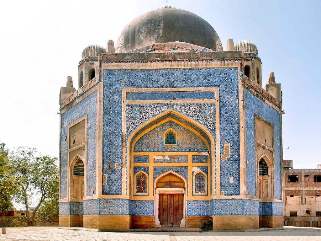
Figure 1.8 Tomb of Ghulam Shah Kalhoro

Figure 1.9 Boundary Wall of Kachha Qila
Picnic Spots/ Recreational Areas
Following are the tourist attractions of the district:
- Rani Bagh: This garden is located in Hyderabad city. Rani Bagh was constructed as a botanical garden in 1861 and named Das Gardens. Over time, animals were moved in, and it was converted into a zoological garden. Once Rani, the garden’s resident elephant moved in, Das Gardens began to be referred to as Rani Bagh by the local community. It is spread over 57 acres and has 4 parks: the Eidgah, the Abbas Bhai Park, zoo and lawns, and children parks with jogging tracks and parking areas
- Mir Tombs: Sandstone tombs of the former rulers of Sindh in Hirabad
- Sabzazar: A restaurant in Hyderabad city, open only in the evenings. It now has a sister restaurant called Al Aliyo which is open during the day
- Sindh Museum: It features the history and heritage of Sindh andIndus Valley Civilization. Items from various historically important dynasties that ruled Sindh including the Samma, Soomra, Kalhora and Talpur dynasties can be found at the museum
- Institute of Sindhology Museum: Institute of Sindhology is one of the major resources on the history ofSindh. It is the first research institution of its kind, and has brought Sindhology (the study of Sindh’s history and culture) to the forefront of international research on the region. The institute hosts a museum; artifacts on display represent the history and demography of the region. The collections consist of archaeological material, woodwork, thread-work, metal work, leatherwork, pottery, jewelry, coins, armaments, photographs, and paintings that have been collected over time for the museum and the institute. The collection efforts have been ongoing since the 1970s
- New Hyderabad City: This is a well-known, privately developed area in the outskirts of Hyderabad, best known for its famous Lake View Park, a 12 acre park featuring a man-made lake and beautiful gardens. The park has become a recreational spot for local families, especially on national holidays
- Miani forests: Located at a 9 km distance from Hyderabad, the Miani forests have been developed into a recreational area. A battle between the British and the forces of Talpur Amirs was fought in the region in 1843 at which the Talpurs were defeated by the British. The region hosts a war monument and a Rest House
- Kisano Mori: Located about 18 km from Hyderabad, Kisano Mori is another recreational area featuring small cafes and facilities for swimming
- Niaz Stadium: Cricket is the most popular game in Hyderabad city. The city’s home team is the Hyderabad Hawks and Niaz Stadium is their home ground

Figure 1.10 Rani Bagh Entrance

Figure 1.11 Sindh Museum Hyderabad
[1] Exact locations are not available; the list has been compiled from that published in Guidelines for Sensitive and Critical Areas Pakistan, issued by Government of Pakistan
[1] Imperial Gazetteer of India v.13 p. 321
Topography of Hyderabad District
Hyderabad district is a part of the Lower Indus Plain which is a vast alluvial plain along the course of River Indus. The Indus divides Dadu district from Hyderabad and stretches 110 kms on the western flank of the district. Agricultural cultivation in the district is dependent upon canal irrigation.
A small limestone range called Ganjo Hills (Bald Hills), an off shoot of the Kirthar Range, runs nearly due South, parallel to River Indus, for about 22 km (14 miles) within the district, protecting Hyderabad city from the Indus River’s seasonal floods. The highest point in the hills is known as Gaho, which is about 75 meters above sea level. There are also 2 small hillocks on the North of Tando Muhammad Khan town. The hillocks are called Budha ka Takkar. The rest of the district is fertile plain with an elevation of about 50 meters above sea level.
Rivers, Streams, and Lakes – Forests – Soils – Climate – Seismic Activity
Rivers, Streams, and Lakes; Hyderabad district
The only river/ stream in the district is River Indus, which flows along the western boundary of the district, separating it from Jamshoro district. There are no lakes or marshes in Hyderabad. Most of the district’s fresh water supply comes from the River Indus and its canals and distributaries.
Forests; Hyderabad district
The Forest Department Hyderabad looks after the forests in Hyderabad. Total area under its jurisdiction is 7,119.9 HA[1]. The district is home to riverine forests and irrigated plantations.
The predominant plant species of riverine forests include babul (Acacia nilotica), bahan or Euphrates poplar (Populus euphratica), athel pine or farash (Tamarix aphylla), lai or salt cedar (Tamarix dioca) and kandi (Prosopis cineraria).
Miani Forest is an irrigated plantation/ forest of Hyderabad district. Ritha or soap nut tree (Sapindus trifoliatus) is an important tree in this forest. Other flora include talhee or shisham (Dalbergia sissoo), babul (Acacia nilotica), mulberry (Morus alba), neem (Melia azadirech), cono or common tug tree (Conocarpus lanrcifolius), and simal or cotton tree (Salmalia malabarica or Bombax cieba), all grown for various economic and environmental returns.
Some of the riverine forests of the district include[2]:
| Railo Forest | 399 HA |
| Karo Khaho Forest | 2,926 HA |
| Keti Mehrani Forest | 5,491 HA |
| Haji Pur Forest | 1,336 HA |
| Dhandh Dhabo Forest | 215 HA |
Table 1.3 Hyderabad Forests
The difference in total forest area as reported by Sindh Development Statistics 2017-2018 and the data in the table above is because this data includes forests spanning Jamshoro district, Tando Allahyar district, Matiari, and Tando Muhammad Khan districts in addition to Hyderabad district.
Soils; Hyderabad district
The soils of the area are mainly formed by alluvial sediments deposited by the Indus River.
Climate; Hyderabad district
Hyderabad district belongs to the wicholo or the middle climatic region of Sindh. Here, the days are hot, but the nights are cool because of the breeze that blows at night.
The climate of the district is moderate. The months of May and June are very hot, with a maximum and minimum average temperature range of 41 °C and 26 °C. There is an abrupt fall in temperature at night with a pleasant breeze, which make nights comfortable. December and January are the coldest month with maximum and minimum temperatures of 25 °C and 11 °C. Sometimes cold winds from Balochistan make the winter severe. Humidity is at its lowest during May and highest in August. Fogs are common in the cold season.
The district lies in rain shadow areas. Heavily laden southwest Monsoon clouds rising from the Arabian Sea pass over this area without any showers except occasionally during the month of July. In winter the district gets some rain from the cyclonic winds blowing from the Persian Gulf. Mean annual rainfall of the district is 155 mm.
Seismic Activity/Seismicity; Hyderabad district
Hyderabad falls in Zone 2 A of the Seismic Zone Map of Pakistan[3] which means minor damage due to earthquakes.
[1] Sindh Development Statistics 2017-18; Forestry Data
[2] Study of Riverine Forest Upstream Sukkur and Downstream Kotri 2008, for Indus for all Program WWF Pakistan.
[3] Please see chapter on Pakistan for the map
Population; Hyderabad district
The following table shows the population figures for the district[1]:
| District/Taluka | Area km2 | Population | Male% | Female% | Urban% | Growth Rate % |
| Hyderabad District | 996 | 2,199,000 | 52.1 | 47.9 | 16.7 | 2.1 |
| Hyderabad City | 43 | 755,290 | ||||
| Hyderabad Rural | – | 466,770 | ||||
| Qasimabad | – | 304,899 | ||||
| Latifabad | 204 | 672,504 |
Table 1.4 Hyderabad Population Statistics
Religions; Hyderabad district[2]
| Muslims | 92.2% |
| Christians | 1.1% |
| Hindus | 6.1% |
| Ahmadis | 0.1% |
| Scheduled Castes | 0.1% |
| Others | 0.1% |
Table 1.5 Hyderabad Religions
Languages; Hyderabad district[3]
| Urdu | 36.9% |
| Punjabi | 5.1% |
| Sindhi | 48.9% |
| Pushto | 2.3% |
| Balochi | 0.8% |
| Seraiki | 1.6% |
| Others | 3.9% |
Table 1.6 Hyderabad Languages
[1] 2017 Census
[2] 1998 Census; 2017 Census data has not been made public yet.
[3] 1998 Census; 2017 Census data has not been made public yet.
Economic Activity – Economic Infrastructure
Economic Activity; Hyderabad District
The major economic occupations[1] of the district are:
- Agriculture, Forestry, Fishing & Hunting (57.8%)
- Construction (14.5%)
- Wholesale, Retail, Hotels/ Restaurants (18.8%)
- Community, Social & Personal Services (18.8%)
Land Use ; Hyderabad district
The following table shows the main land use statistics for the district[1]:
| Land Use | Area | Land Use | Area |
| Geographical Area | 101,000 HA | Reported Area | 101,000 HA |
| Cultivated Area | 61,000 HA | Current Fallows | 30,000 HA |
| Net Area Sown | 31,000 HA | Forest Area | 7,000 HA |
| Culturable Waste | – HA |
Table 1.7 Hyderabad Land Use Statistics
Irrigation Network; Hyderabad district
The district is mostly irrigated by the Indus Basin Irrigation System. The figures for various types of irrigation being used in the district[1] are as follows:
| Total Irrigated Area | 26,132 HA | Un-irrigated Area | 4,579 HA |
| Canal Irrigated | 19,023 HA | Tube Well irrigated | 7,109 HA |
| Well Irrigated | -HA |
Table 1.11 Hyderabad Irrigation Statistics
Hyderabad district is irrigated through the canals off-taking from Kotri and Sukkur Barrages. The main canals are the Rohri Canal (Sukkur Barrage), Northwest Canal (Sukkur Barrage), Kalri Bhaggar Canal (Kotri Barrage), Phulleli Canal (Kotri Barrage), Pinyari Canal (Kotri Barrage) and Akram Wah Canal (Kotri Barrage). A network of small distributaries in the district also provides water. Two such distributaries are the Husri Distributary, and Hassan Ali Wah.
Agriculture; Hyderabad district
A part of Hyderabad district belongs to the Indus Delta, and another part belongs to the Southern Irrigated Plain Agro-Ecological Zone of Pakistan. Most of the agricultural activities of the district are restricted to the Hyderabad Rural Taluka. The major crops of the district are wheat, sugarcane, cotton, rice, gram, jowar, rape and mustard seed, bajra, maize, sesanum, moong, maash, masoor, sugar beet, guar seed, linseed, sunflower, and fodder.
Fruits of the district are mango, guava, banana, apples, chikoo, jaamun, watermelon, musk melon, phalsa, citrus, ber, mulberry, papaya, and coconut.
Vegetables of the district are tomato, potato, onion, peas, okra, tinda, brinjal, bitter gourd, bottle gourd, pumpkin, luffa, cucumber, long melon, beans, field vetch, turnip, carrots, spinach, cauliflower, cabbage, sweet potatoes, radish, garden peas, fenugreek, lettuce, chilies, spearmint, garlic, coriander, ajwain, and fennel.
Livestock Breeding; Hyderabad district
The following table shows livestock population in Hyderabad district[1]:
| Cattle | 76,000 Heads | Buffaloes | 309,000 Heads |
| Sheep | 29,000 Heads | Goats | 296,000 Heads |
| Camels | 1,000 Heads | Horses | 2,000 Heads |
| Asses | 16,000 Heads | Mules | – |
Table 1.8 Hyderabad Livestock Statistics
Red Sindhi cow, barbary goat, and some breeds of thorough bred horses are indigenous to Hyderabad district.
Poultry Farms; Hyderabad district
Commercial poultry farming is taken up on a large scale in Hyderabad. There are 415 government owned poultry farms[2] in Hyderabad district.
Fishing; Hyderabad district
Inland fishing is taken up at a large scale in the district, with Pallo fish being a much cherished delicacy. Fishing is carried out in the River Indus as well as canals of the district.
Bee Keeping; Hyderabad district
Honeybee keeping was introduced in Pakistan in the 1980s, when IUCN and UNDP introduced apiculture to the coastal villages of Sindh, including those located in Dadu. Since then, honeybee keeping has been slowly and gradually growing as a cottage industry in nearly all parts of Pakistan.
Minerals and Mining; Hyderabad district
The hilly areas of the district are rich in minerals; however, only 2 minerals—limestone and flint stone—are being mined. Other important minerals found and regularly utilized in the district are Oil and Gas. Bukhari and Nari are 2 important gas wells and Kunnar, Bukhari, Nari, and Tando Alam are 4 oil fields producing crude oil in the district.
Industry and Manufacturing; Hyderabad district
Hyderabad is a major industrial district having a large number of industries in 3 Industrial Estates. The district produces all the glass bangles being manufactured in the country. Other important industries of the area include the following[1]:
| Industry | # of Units | Industry | # of Units |
| Food Products & Beverages | 41 | Manufacturing of Textile | 18 |
| Chemical & Chemical Products, Rubber & Plastic Products | 05 | Paper & Paper Products, Coke & Petroleum | 05 |
| Wearing Apparel | 04 | Other non-Metallic Mineral Products | 10 |
| Basic Metal, Motor Vehicles & Trailers | 04 | Fabricated Metal Products | 03 |
| Machinery & Equipment | 04 | Other Transport Equipment | 04 |
Table 1.9 Hyderabad Industry
According to Hyderabad Economic Profile 2008 by Small Medium Enterprise Development (SMEDA), Hyderabad houses various small and medium scale manufacturing clusters. These clusters belong to different sectors of the economy and are playing their role efficiently with the large scale manufacturing industries at Hyderabad. They are present within the city and are housed in small plots. These small and medium scale manufacturing clusters employ thousands of people and need to be extended and diversified in some other sectors as well. The industries are as follows:
- Glass Bangle (Polishing, Cutting, Smoothening works)
- Leather Footwear (Shoes, Sandals, Chappal)
- Gold and Silver Jewelry
- Confectionary (Biscuits, Wafers, Toffees, Candies, Chips)
- Corrugated Packages
- Textile Looms (Manual and Power Looms)
- Flour and Daal Mills
- Plastic Injection Molding (Plastic Bottles, Polyethylene Bags, Plastic Containers)
- Furniture (Wooden, Iron, and Wrought Iron)
- Marble Processing Plants
- Oil Spillers
- Handicrafts
- Carpets
According to the same study by SMEDA, the Sindh Small Industries Corporation Industrial Estate, Hyderabad (SSIC Industrial Area) houses 63 small scale industries out of which 43 units are functional and the rest are non-functional. Major clusters and sectors of this site are
- Glass Bangles Industries
- Oil Mills
- Flour and Daal Mills
- Plastic Works
- Light Engineering (6 Motorcycles Assemblers, as well as numerous Foundry and Steel Re-Rolling Mills)
SMEDA also shows that the Sindh Industrial and Trading Estate, Hyderabad (SITE) houses 389 units, out of which 166 are running whereas 223 are non-operational units. Major clusters and sectors of this site are
- Textile Mills (Spinning, Yarn)
- Glass Bangles Industries
- Oil Mills
- Flour Mills
- Daal Mills
- Pharmaceuticals
- Heavy and Light Engineering
Sindh Industrial and Trading Estate, Super Highway Hyderabad houses 96 industrial units of which 46 units are functional and 50 units are non-functional. Major clusters and sectors on this estate are
- Food
- Garments
- Handicrafts
Handicrafts; Hyderabad district
Hyderabad is a center for handicrafts from all over Sindh. Most important handicrafts of the district are calico, embroidery, bracelets, lacquered wood furniture, hand-loom cloth (sousi and ajrak), rilli, block printed colorful chadars (shawls), bangles, shoes, and glazed tiles, leatherwork, glazed pottery and tiles, khes (cotton blankets), and anguchahs (cotton cloth) from Naseerpur (Northeast of Hyderabad). Kundan (Glass inserted gold jewelry), Sindhi topi, garbi cloth, and lungi cloth are also made in the district.

Figure 1.5 Bangles Manufactured in Hyderabad
Economic Infrastructure; Hyderabad District
Serving as a socio-economic crossroad to the lesser developed cities and towns in Sindh and linking and networking them with the bigger towns and cities in the nation, Hyderabad holds importance as a vital transportation link using every service—it can be reached by all means of transportation, be it air, land, water, or rail.
Road Statistics; Hyderabad district
Hyderabad is one of the most important milestones along the route of National Highways. It is the junction of the National Highway N-5, the longest highway of Pakistan, and the Motorway M-9 (also known as Super Highway) via a link road. Indus Highway or National Highway N-55 starts at Hyderabad to go up to Torkham in Khyber Agency of Federally Administered Tribal Agency (FATA).
According to Road List 2009 (Latest available) issued by the Government of Sindh, the road statistics of the district are as follows:
| Provincial Highways | 204.9 km |
| Access Roads | 1,268.9 km |
| Secondary Roads | 1,936.5 km |
Table 1.10 Hyderabad Road Statistics
The Sindh Development Statistics 2017-18 shows that the total length of black topped roads in Hyderabad district is 420 km.
Besides the Indus Highway and Motorway M-9, important roads of the district include:
- National Highway N-105 (Hyderabad-Khokrapar)
- Hala-Shahdadpur-Sanghar Road
- Tando Allahyar-Tando Adam Road
- Hyderabad-Mirpurkhas Road
- Hyderabad-Badin Road
- Hyderabad-Tando Ghulam Ali Road
- Tando Muhammad Khan-Sujawal Road
Bus Terminals
There are 7 major bus terminals within the Hyderabad city area:
- Badin Bus Stop near SITE
- Tando Bago Coach Stop near old sabzi mandi
- Jacobabad-Larkana Bus Stop at Pathan Colony
- Nawab Shah Bus Stand at Halla Nakka
- Sanghar Coach Stop near Civil Hospital
- Karachi Bus Stand near Qasim Chowk
- Sammi Daewoo Bus Service to Karachi at Auto-Bhan Road and Latifabad U7
Rail and Airways; Hyderabad district
Hyderabad Junction Railway Station, a busy railway station in Hyderabad city, is the main railway station connecting the district to Peshawar in the North, to Karachi in the South and to Quetta in the East.
Hyderabad has an airport in Hyderabad city where chartered flights can land.
Figure 1.12 Busy Railway Junction Hyderabad
Radio and Television; Hyderabad district
Hyderabad has its own Radio station which broadcasts in both AM and FM, and in both Urdu and regional languages. Hyderabad has 3 privately owned TV channels operating from the city, namely Kawash TV Network (KTN), Sindh TV, and Kashish TV.
Telecommunications; Hyderabad district
Internet and new social media is popular in Hyderabad, with PTCL, and all major mobile companies providing services throughout the district.
Post Offices/ Courier Services; Hyderabad district
Since Hyderabad is mainly an urban district, there are a large number of post offices and courier service providing their services in the district.
Banking/ Financial Institutions; Hyderabad district
Most of Pakistan’s major banks have their branches in the district. Those with branches[1] in the district include:
- Al Baraka Bank Ltd.
- Allied Bank Ltd.
- Askari Bank Ltd.
- Al Falah Bank Ltd.
- Al Habib Bank Ltd.
- Bank Islami Pakistan Ltd.
- Burj Bank Ltd.
- Dubai Islamic Bank Ltd.
- Faysal Bank Ltd.
- First Women Bank Ltd.
- Habib Bank Ltd.
- Habib Metropolitan Bank Ltd.
- JS Bank Ltd.
- KASB Bank Ltd.
- Muslim Commercial Bank Ltd.
- Meezan Bank Ltd.
- National Bank of Pakistan
- National Investment Bank Ltd.
- Silk Bank Ltd.
- Sindh Bank Ltd.
- Soneri Bank Ltd.
- Standard Chartered Bank Ltd.
- Summit Bank Ltd.
- The Bank of Khyber ltd.
- The Bank of Punjab Ltd.
- United Bank Ltd.
- Zarai Taraqiati Bank Ltd.
In all there 164 branches of conventional and 48 branches of Islamic banks in the District.
Electricity and Gas; Hyderabad district
Hyderabad has its own electricity distribution company called Hyderabad Electric Supply Company (HESCO). HESCO is owned and operated by Water and Power Development Authority (WAPDA). The district gets electricity from the national grid.
Educational Institutions; Hyderabad district
The literacy rate of the district is 59%, with 64% literacy in urban areas and 35% in rural areas.
As a gateway between rural and urban Sindh, Hyderabad city attracts students from the lesser developed regions of the district. Hyderabad has a large number of schools, colleges, and universities. The University of Sindh, Mehran University of Engineering and Technology, Liaquat University of Medical Sciences, Sindh Agricultural University, University of EAST, and ISRA University are the degree awarding institutions in Hyderabad.
A list of government educational institutions in Hyderabad is as follows[1]:
| Institution | Boys/Girls | Institution | Boys/Girls |
| Primary Schools | 606/104 | Middle schools | 50/26 |
| Secondary schools | 52/30 | Higher secondary | -/1 |
| Post Graduate colleges | 5/1 | Degree colleges | 5/7 |
| Technical Institutes | 4/1 | Commercial Institutes | 2/- |
| Vocational Institutes | 2/4 | Engineering Colleges/Universities (Private) | 01[2] |
| Number of Universities | 05[3] |
Table 1.12 Hyderabad Educational Institutes
There are 35 private schools in various parts of the district. In addition, there are campuses of 18 different types of colleges. There are 12 private institutions, awarding Diplomas in various skills and trades.
Healthcare Facilities; Hyderabad district
The following table shows the Government Health Care Institutions in Hyderabad district[4]:
| Institution | No./Beds | Institution | No./Beds |
| Teaching Hospital | 01/1,316 | Specialized Hospital | 01/496 |
| Government Hospitals | 13/742 | Dispensaries | 67/ – |
| Rural Health Centers | 03/40 | Basic Health Units | 18/36 |
| T B Clinics | 03/ – | Mother Child Health Centers | 07/ – |
| Private Hospitals | 20/1,215 | Private TB Clinics | 02/ – |
| Private Dispensaries | 154/16 | Private MCHC | 06/ – |
Table 1.13 Hyderabad Health Institutes
In addition there are 2Lepresy clinics, 1 homeo dispensary, 1 urban health unit and 1 trauma emergency center in the district (all public)
Policing; Hyderabad district
Additional Inspector General of Police (AIGP) is in charge of the police force in Hyderabad. This AIGP looks after 13 districts of Sindh. 9 District Police Officers (DPOs) report directly to the AIGP. The DPO Hyderabad is incharge of the overall law and order situation in the district. There are 24 police stations in the district including one women’s police station.

Figure 1.13 Niaz Stadium, Hyderabad

Figure 1.14 State Bank Building Hyderabad
[1] Sindh Development Statistics 2017-18
[2] University of EAST (Engineering, Arts, Science & Technology; Private)
[3] ISRA University of Health Sciences (Private), Agricultural University (Public), Elsa Kazi Campus of Sindh University (Public), National University of Modern Languages & Sciences (NUML; Public), SZABIST Hyderabad Campus (Private)
[4] Health Profile Sindh District 207-18
[1] List of reporting Bank Branches by State Bank of Pakistan, 2019
[1] Census of Manufacturing Industries 2005-06, latest available
[1] Sindh Development Statistics 2017-18
[1] Sindh Development Statistics 2017-18
[2] Table 17 (Number of Commercial Poultry Farms and Number of Birds by Size of Flock).
[1] Sindh Development Statistics Sindh 2017-18
[1] 1998 Census. The figure includes data for Tando Allahyar, Matiari, and Tando Mohammad Khan Districts also; 2017 Census data has not been made public yet.
Environment and Biodiversity; Hyderabad District
Since Hyderabad is mostly an urban district (Hyderabad Rural is the only rural taluka of the district) it faces all the problems of environmental degradation which urban areas in developing countries face. There is a lot of air pollution from traffic fuel combustion and effluents from industries, especially from brick kilns, and tanneries among others.
Flora and Fauna; Hyderabad district
Flora; Hyderabad district
The district belongs to the Riverine Tract Habitat of Sindh. The dominant flora of this riverine tract includes varieties of lai (Tamarix), wild sugar cane (Saccharum), poplar (populus) and babul (Acacia). Bulrush (Typha) growth is common wherever the water is stagnant or slow moving, for example near dhands.
Other flora includes jand (Prosopis cineraria), khejri (Prosopis specigara), bahan (Populus euphratica), ber (Zizyphus numularia), lai (Tamarisk gallica) and jhao (Tamarisk dioca). On the roadside and in gardens Indian Fig (Ficus indica), pipal (Ficus religious) the siras (Mumosa sirissa), neem (Azadirachta indica) and tamarind (Tamarandus indica) are found.
Ornamental flowers grown in the district are roses, jasmine, and tuberoses.
Fauna; Hyderabad district
Mammals found in the riverine forests include the hog deer, wild boar, jackals, wolves, and porcupine. Among birds, partridges (both black and grey), and the sand grouse are common in the forest plantations. Many varieties of waterfowl like cattle egret, Indian reef heron, and Mongolian sand plover are also found. Other birds found in the district are little brown dove, koel or cuckoo, Indian scoop owl, and Indian great horned owl.
Protected Areas and Wildlife; Hyderabad district
The following areas have been declared as Protected Areas by the Government of Pakistan:
- Miani Dhand (Wetland); Hyderabad district
- Sahib Sammo (Game Reserve); Hyderabad district
Endangered fauna include hog deer, black and grey partridges, and sand grouse.