Share now
Map of Sindh

Map of Tharparkar District

Sindh Districts
- Karachi District Profile
- Badin District Profile
- Dadu District Profile
- Ghotki District Profile
- Hyderabad District Profile
- Jacobabad District Profile
- Jamshoro District Profile
- Kashmore District Profile
- Khairpur District Profile
- Larkana District Profile
- Matiari District Profile
- Mirpurkhas District Profile
- Naushero FerozeDistrict Profile
- Sanghar District Profile
- Shahdadkot District Profile
- Shaheed Benazirabad District Profile
- Shikarpur District Profile
- Sukkhur District Profile
- Tando AllahYar District Profile
- Tando Mohammad Khan District Profile
- Tharparkar District Profile
- Thatta-Sajawal District Profile
- Umerkot District Profile
Also visit: Punjab, Balochistan, Khyber Pakhtunkhwa
Tharparkar District Profile
Introduction/Geographical Location; Tharparkar District
Geographically and historically, Tharparkar has remained a part of the Great Indian Desert or the Thar Desert. The district derives its name from the words Thar and Parkar. The etymological origin of the word Thar is Thul, which is the general term used for the sand ridges of the region; Parkar literally means “to cross over” or “the other side”. The eastern part of the desert ends at the irrigated western part and thus, one “crosses over” to the irrigated, Parkar, areas. During British rule, the district was known as Thar and Parkar district, which, over time, became one word: Tharparkar.
The district is situated between 24° 9Ꞌ 35” to 25° 43Ꞌ 6” North latitudes and 69° 03Ꞌ 35” to 71° 07Ꞌ 47” East longitudes. The district is bounded in the North by Mirpurkhas and Umerkot districts, in the East by India (Barmar and Jaisalmir districts), in the West by Badin district, and in the South by Runn of Kutchh.
Tharparkar District at a Glance
| Name of District | Tharparkar District | ||
| District Headquarter | Mithi Town | ||
| Population[1] | 1,647,036 persons | ||
| Area[2] | 19,638 km2 | ||
| Population Density [3] | 83.9% persons per km2 | ||
| Population Growth Rate[4] | 3.1% | ||
| Male Population[5] | 53.5% | ||
| Female Population[6] | 46.5 % | ||
| Urban Population[7] | 8.1% | ||
| Tehsils/Talukas |
07 Talukas: 1. Chachro Taluka 2. Diplo Taluka 3. Mithi Taluka 4. Nagarparkar Taluka 5. Dhali Taluka 6. Islamkot Taluka 07 Kaloi Taluka[8] |
||
| Main Towns | Islamkot, Naukot, Mithi, Diplo, Bhalwa (village), Parinagar, Virawah, Warwai, Bhodesar, Nagarparkar, Umerkot, Gori, Chalhar, Kaantyo, Kaloi, and Kasbo | ||
| Literacy Rate[9] | 29% | ||
| Male Literacy Rate[10] | 43% | ||
| Female Literacy Rate[11] | 29% | ||
| Major Economic Activity[12] | Agriculture, Fishing, Hunting | 77% | |
| Elementary Occupations | 9.4% | ||
| Crafts & Related Trades | 5.1% | ||
| Service Workers, & Shop & Market Sales Workers | 3.4% | ||
| Others | 5.2% | ||
| Main Crops | Cotton, sugarcane, bajra, sesanum, wheat, rapeseed & mustard, moong, maash, arhar, sugar beet, guar seed, linseed, sunflower, and castor seed | ||
| Major Fruits | Mango, papaya, watermelon, musk melon, citrus, ber, and mulberry | ||
| Major Vegetables | Tinda, okra, brinjal, bitter gourd, carrots, spinach, tomatoes, turnips cabbage, peas, chilies, garlic, and coriander | ||
| Forests (Area)[13] | – HA[14] | ||
| Metalled Roads[15] | 1,248 km | ||
| Shingle Roads[16] | – km | ||
| No of Grid Stations[17] | 6, with capacity of 66 KV each | ||
| Industrial Zones | No Industrial Estates, but there are some small industries in the district | ||
| Industrial Units[18] | Ice Factory | 1 Units | |
| Carpet Industry | 5 Units | ||
| Flour Mills | 38 Units | ||
| Household Size[19] | 5.6 persons per household | ||
| Houses with Piped Water Inside[20] | 9.4% | ||
| Houses with Electricity[21] | 25.5% | ||
Table 1.1 Tharparkar District at a Glance
[1] 2017 Census
[2] 2017 Census
[3] 2017 Census
[4] 2017 Census
[5] 2017 Census
[6] 2017 Census
[7] 2017 Census
[8] Carved out of Mithi Taluka and Diplo Talukas
[9] Pakistan Social & Living Measurement 2018-19 (PSLM); latest available.
[10] PSLM
[11] PSLM
[12] 1998 Census; 2017 Census Data has not been made public yet.
[13] Sindh Development Statistics 2021-22
[14] Land Utilization Statistics has area under forests at 69,266 HA
[15] Sindh Development Statistics 2021-22
[15] Sindh Development Statistics 2021-22
[16] 2017 Census
[17] Environmental & Social Assessment HESCO by Elan Partners Ltd.2007 ; latest available.
[18] Tharparkar District Profile by Norwegian Pakistan Partnership Initiative (NPPI) 2009 (Latest available)
[19] 1998 Census; 2017 Census Data has not been made public yet.
[20] 2017 Census
[21] 2017 Census.
Brief History – Governmental Structure – Administrative Divisions – Historical/Heritage Sites and Recreational Sites
Brief History; Tharparkar District
This region is part of the Great Thar Desert, which covers a total area of about 446,000 km2 and forms a natural border between India and Pakistan. About 85% of the Thar Desert is in India, in the Indian State of Rajasthan, where it extends up to Haryana and Gujarat. In Pakistan, this desert is situated on the eastern border of Sindh province, and extends to the southeastern parts of Punjab, where it joins the Cholistan Desert. District Tharparkar is one of the major parts of this desert area in Sindh.
The geological origin[1] of the Thar Desert is contested. Some consider it to be 4,000 to 10,000 years old, whereas others state that aridity started in this region much earlier. Another theory states that the area became a desert relatively recently, estimated to be around 2000 to 1500 BC. The Ghaggar-Hakra[2] River’s bed, which is thought to have dried-up around this time, was, before 1500 BC, a water source for the Indus Valley Civilization, especially Mohen-jo-Daro.
According to the Imperial Gazetteer of India:
Very little is known of the early history of the District…The Soda Rajputs, the upper class of the District who are said to be the descendants of the Parmara Soda, [also spelled Sodha] are supposed to have come to this part of Sindh from Ujjain about 1226 AD, when they quickly displaced the rulers of the country. Some authorities believe that they captured this area from the Soomras in the beginning of the sixteenth century. (v. 23, p. 307)
Other authorities believe that in 1226 AD, a battle between the Soomra and the Sodha resulted in the Soomra defeat. Raj Dev Sodha, then, established his rule in Umerkot[3] and founded the Sodha Dynasty, the chief/ leader of which was given the title of Rana. After the conquest of Umerkot, the Sodhas began to capture parts of Mithi, Chelhar, and Chachro, thus extending their control up to Nagarparkar. Four generations of the Sodha ruled and lived in Umerkot, after which, the last Sodha ruler of Umerkot divided his state between his two sons, bequeathing Umerkot and the adjoining areas to one, and the Nagarparkar areas to the other. The Sodha ruled the region till 1609 AD. From 1609 to 1736, Thar remained under Sindhi rulers (the Kalhora, for example, directly) and under Delhi rule intermittently. Occasionally, one of the Sodha descendants would declare themselves as the ruler of the region, only to be replaced by others, making the region a contested one. In 1782, the Talpurs wrested Thar from the Kalhoras/ Sodhas. The Talpurs ruled it for 61 years and built a number of forts for protection against outside forces. In 1843, this area was annexed by the British along with the rest of Sindh.
While discussing the British conquest of the region, the Imperial Gazetteer of India shows that:
The Thar and Parker District was for a long time headquarters of banditti, who made plundering excursions into Cutch [now Ketch] and other neighbouring districts. The British government intervened in 1832 and through the Agency of Captain (later General) Roberts suppressed the marauders. Posts of mounted men were retained in the country for the preservation of order until the conquest of Sindh in 1843. (v. 23, p. 308)
When Sir Charles Napier annexed Sindh in 1843, Thar and Parkar areas along with Diplo, Islamkot, Mithi, Baliari, Singala, Virawah (also spelled Warwai), Pitapur and Bhodesar were merged to form the Cutch (now Kutch) Political Agency. Umerkot, Gadra, and other tracts of Nara became a portion of Hyderabad district. Sindh was divided into provinces and was assigned Zamindars to collect taxes for the British; these Zamindars were also known as Waderas. The Sodha chiefs/ Ranas were forbidden to bear arms. In 1846, the areas rebelled against this provision, but the British quelled the rebellion. The Sodha, who were the main instigators of the rebellion, entered into negotiations[4] with the British. As a result of these negotiations, the Sodhas were granted some concessions like lands for cultivation and the ability to keep 5% (per annum) interest on the fees they collected from the Baniya (or tax collectors, moneylenders, merchants) of the region. In 1859, another rebellion broke out which was quelled by Colonel Evans of Hyderabad. The town of Nagarparkar was occupied by him on behalf of the British colonial powers, and the Sodha Rana was captured and killed.
In 1856, the desert portion of Thar and Parkar was incorporated in the province of Sindh. In 1858 the entire area became a part of Hyderabad. Subsequently, in 1860, it was renamed Eastern Sindh Frontier, with its headquarters at Umerkot, and was governed by a Political Superintendent. In 1882, the region was designated as district and its administrative head was a Deputy Commissioner. In 1906, the headquarters of the district was shifted from Umerkot to Mirpurkhas.
The area became a part of Pakistan in 1947; the first administrative change to the district was made in December 1990, when the district Thar and Parkar was bifurcated into 2 districts—Mirpurkhas, and Thar and Parkar. Thar and Parkar district had its headquarters at Mithi. In October 1993, the name of the district was changed from Thar and Parkar to Tharparkar.
Governmental Structure; Tharparkar District
At the Federal level, Tharparkar district is allocated a set number of representatives in both the National Assembly and the Provincial Assembly:
- Number of seats in the National Assembly 02 +1 reserved seat for minorities
- Number of seats in the Provincial Assembly 04
Tharparkar has one Municipal Committee, i.e. Mithi, and 6 Town Committees as follows:
- Islamkot
- Chelhar
- Diplo
- Chachro
- Kheme-jo-Par
- Nagarparkar
Administrative Divisions; Tharparkar District
Between 1947 and 2014, the district was divided into 4 Talukas (tehsils) but in April of 2014, 2 more Talukas were created, adding Union Councils from other Talukas:
| Mithi | 09 Union Councils |
| Islamkot | 09 Union Councils |
| Chachro | 08 Union Councils |
| Dahli | 07 Union Councils |
| Kaloi | Carved out of Mithi and Diplo Talukas. Other data not available. |
| Nagarparkar | 07 Union Councils |
| Diplo | 08 Union Councils |
Table 1.2 Tharparkar Administrative Divisions
Historical/Heritage Sites/Recreational Sites; Tharparkar District
Following are some of the important tourist attractions and recreational sites in Tharparkar:
- Naukot; Tharparkar District: This is known as the gateway of the desert. This town has a fort built during the Talpur period; it was built in 1814 by Mir Ali Murad Talpur. This fort still survives in its original shape. The Talpur also built forts in Islamkot, Singaro, and Mithi, but these are not as well-preserved as the fort of Naukot
- Mithi; Tharparkar District: This is the headquarters of Tharparkar district and the biggest town in the desert. It is a famous center for Thari handicrafts like embroidered bed sheets, shirts, shawls, baby hats, wall hangings, horse and camel trappings, silver jewellery, and antique carved, wooden chairs, as well as small wooden keepsake boxes. The goods are for sale in private houses and in the town’s bazaars. Beyond Mithi, the desert begins, and sandy tracks weave between dunes covered with low flowering shrubs. Vultures, buzzards, eagles, kites, and many other species of small scavengers can be seen. Some of the villagers keep peacocks, which are considered sacred, and are protected by the populace
- Diplo: Diplo is an ancient town of Mithi Taluka, and is situated at a distance of 40 km from Mithi. Diplo is famous for handicrafts, especially handmade carpets
- Gorhi-Jo-Mandir (Temple); Tharparkar district: This is an ancient temple situated approximately 23 km (14 miles) in the Northwest of Virawah in Thar. It is a symbol of unique ancient construction. It is believed that it was constructed by Goricho, a Jain worshiper, in 300 AD. This temple is protected under government laws
- Bhalwa; Tharparkar district: This village is ascribed as the native village of Marvi, who is the legendary heroine of the popular love story Umar-Marvi. According to this story, Marvi resisted the unwelcome attentions of Umar, who was a powerful king, in order to stay in her village and marry her betrothed. The name Bhalwa derives from the Bheel clan who settled in this village and named it Bhalwa
- Virawah; Tharparkar district: This village is located 24 km from Nagarparkar hills at the beginning of the Nagarparkar region. The brick ruins of the old city of Parinagar are on the West of Virawah. The ruins of a number of Jain temples and other historic sites are located in this village
- Parinagar; Tharparkar district: Located at the mouth of the Runn of Kutchh, the city is believed to have been founded as a seaport in the 5th or 6th century BC, when a channel of the Runn of Kutchh was actually navigable. This channel was destroyed in the 12th century AD by Emperor Shamsud Din Iltumish, when he attacked the town and destroyed it
- Warwai; Tharparkar district: This is a small village where coal deposits have been discovered
- Kasbo; Tharparkar district: This village houses 2 important Hindu Temples around which festivals are held. The temples are Shri Ramapir Temple and the Shiv Mandir. In addition, there are sweet water wells in the village which help irrigate the surrounding farms, and provide water for domestic uses also
- Nagarparkar; Tharparkar district: This is the chief town of the district, located in the East of a range of the Karoonjhar Hills. Nagarparkar is home to multiple sites, which include:
- Temple of Mahadev: This temple is in Nagarparkar. Below the temple, to the North, is a pool of water at which the Hindu cremation ceremonies are performed
- Fort: Near the pool of the Mahadev temple are the ruins of the fort believed to have been built by Chandan, son of Gobindrai. The fort was destroyed in 1859 by the British Government, but the ruins are still extant
- Anchlisar: An important site with natural springs is Anchlisar, where 3 tanks are maintained and filled by the seasonal spring of the same name
- Bhodesar; Tharparkar district: Situated 3 km (2 miles) to the Northwest of Nagarparkar, beneath the Karoonjhar Hills, this town was a prosperous and affluent city, which is evident from the ancient construction still visible. According to historians, Ghazi Sultan Mehmood Ghaznavi, after the conquest of Somnath in 1026, passed through this desert. During this journey he became lost; in search of water, he arrived at a pond and was able to quench his thirst. Subsequently, he constructed a memorial at Bhodesar, which was later converted into a mosque by Sultan Mehmood Begra
- Gaddi Bhit; Tharparkar district: Located at Mithi, this is the highest elevation point of the town built on a sandhill, and affords a breathtaking, panoramic view of Mithi town
- Marvi-Jo-Koohn; Tharparkar district: This is a well associated with the legendary Umer-Marvi love story. A public cultural center called Marvi Cultural Center has recently been constructed near the ancient well
- Bodesar Mosque; Tharparkar district: This is a mosque built in stone with white marble pillars. It is protected under Government of Pakistan (GoP) Laws
- Bodesar Temple; Tharparkar district: It is protected under GoP Laws
- Jain Temple, Nagarparkar; Tharparkar district: It is protected under GoP Laws
- Mound at Bhiro Sherwah, Tharparkar: It is protected under GoP Laws
- Mound at Shadi Pali, Deh Khuda Buksh, Tharparkar: It is protected under GoP Laws
- The following Tombs are located at Ghitori Goth, Deh no. 24 (these are all protected under the GoP Laws); Tharparkar district:
- Brick Tomb of Arzi Khokar
- Tomb of Mir Khan s/o Karam Khan Talpur
- Tomb of Mir Jado
- Tomb of Mir Murad Khan
- Tomb of Musa Khan
- Tomb of Mir Raio
- Tomb of Shaheed Kapri Baloh
- Other tombs near Shaheed Kapro Baloch
- Tombs of Mir Fateh Khan and Mir Mirza Khan
- Tombs of women of Talpurs
- Tomb of Aulia Pir Ghitori Badshah Qureshi
- Old Mosque Ghitori Goth, Deh no. 24; Tharparkar district
- Naukot Fort, Naukot; Tharparkar district: It is protected under GoP Laws
- Jain Temple, Virawah; Tharparkar district: It is protected under GoP Laws
- Mound at Shadi Pali, Deh Khuda Baksh; Tharparkar district: Protected under GoP Laws
- Mound at Bhiro, Sherwah; Tharparkar district: Protected under GoP Laws
- Temple of Nag Dev, Mithi; Tharparkar district
- Shrine of Syed Razi Shah Lakyari, an 11th Century Arab Saint, Nawankot town; Tharparkar district

Figure 1.3 Gadi Bhit Monument, Mithi

Figure 1.4 Bhodesar Mosque
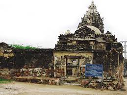
Figure 1.5 Gorhi-jo-Temple (A Jain Period Temple), Virawah
[1] The Unexplored Jewel of the Desert: Prospective Role of Thar Desert in Ecological and Socio-Economic Development of Pakistan, Dr. Yusuf Karakil ÇIK (Turkey) and Masood Nawaz (Kalyar), Turkey
[2] The Ghaggar-Hakra River is a river in Haryana State (India); upstream of Ottu Barrage (in India), it is known as Ghaggar and the name changes to Hakra downstream of this barrage. Hakra is now a dried-out river channel near Fort Abbas City (Bahawalpur) in Pakistan.
[3] Umerkot was part of Tharparkar district till 1993, when it was made into a separate district.
[4] Imperial Gazetteer of India v. 23, p. 308
Topography; Tharparkar District
Topographically, the district can be divided into the following 4 sections:
- Desert: This is the eastern portion of the district, and a part of the largest desert of Pakistan (the Thar Desert) which extends over a vast area of Pakistan and India, from Cholistan to Nagarparkar in Pakistan, and from the South of Haryana down to Rajasthan in India
- Flat areas: These are alluvial, irrigated areas of the district in the western, or the Parkar, region
- Hilly areas of Karoonjhar and other nearby mountains
- Marshy land of Runn of Kutchh
The desert covers the area from Cholistan Desert in Punjab to Nagarparkar in Tharparkar district. It consists of a barren tract of sand dunes (ridges) covered with thorny bushes. The ridges are irregular and roughly parallel, and they often enclose sheltered valleys above which the dunes rise to a height of 46 meters. After a rain spell, these valleys become fertile enough for cultivation, but if the land is not cultivated, it yields luxuriant turfs of grass to be used as fodder for livestock.
There are some tracts called “Parkar” in the Nagarparkar area. This region is a flat region with alluvial deposits comprising of sandy, salty, and salty-plain areas, thereby giving the name Tharparkar to the district. The tracts cover about 500 km2 at the junction of the Great Runn of Kutchh and the Thar Desert.
Karoonjhar Hills are the only hills in the Nagarparkar Taluka on the northern edge of Runn of Kutchh. It consists of granite rocks, probably an outlying mass of the crystalline rocks of the Aravalli Range.[1] This is a small area, quite different from the desert. The tract leading to the mountain is flat and level except in the area close to Nagarparkar itself where there is an extensive area of elevated land known as the Karoonjhar Hills. The Karoonjhar Hills are approximately 19 km in length and attain a height of 305 m. There are smaller hills in the East, which are covered with sparse jungle and pasturage, and give rise to 2 perennial springs. The granite stone of this mountain is used as building material.
In the South of the district is the Runn of Kutchh which is an immense saltwater marsh. It is a flatland, almost at sea level, covered with a thick layer of salt which has been left by the evaporation of sea water over the course of centuries. During the Monsoons, it becomes almost a part of the Arabian Sea due to the influx of sea water at Lakhpat Bunder on Kori and the mouth of the Indus as well as other locations. During the winter, the Runn of Kutchh dries up, and the surface is covered with salt again. During the annual flooding of the region, at places where the land rises a few meters above the surrounding plains, the elevated land becomes an “island” surrounded by the rising waters, and is called bet.
Rivers, Streams, and Lakes; Tharparkar District
There is no stream of fresh water in the district. The Karoonjhar Mountains and the smaller hills in the East (Nagarparkar area) are covered with sparse jungle and pasturage; 2 perennial springs named Achleshwar and Sardharo originate from the hills, as well as temporary streams called Bhetiani and Gordhro, after rains.
Forests; Tharparkar District
Tharparpar is mostly a desert region,n and it thrives mainly on rains which are scant occurring every 3 to 4 years. The underground water is brackish with pockets of sweet water. Due to water scarcity, there are no major forests in the district, but 69,000 HA of wastelands of the district have been designated as protected rangelands.
The major floral species of the rangelands are gum Arabic or khumbat (Acacia senegal), jand (Prosopis cineraria), desert teak or rohida (Tecomella undulate), kikri or baonli (Acacia jacquemontii), peelu or vann (Salvadora oleoides), karir (Capparis deciduas), African foxtail grass (Cenchrus ciliaris), Indian sandbur (Cenchrus biflorus), desert grass (Panicum Turgidum), and bansi grass (Panicum antidotale).
Soils; Tharparkar District
The district lies in the arid zone, the soils of which are generally sandy to sandy-loam in texture. The soil in Tharparkar in general is not fertile, and due to severe wind erosion, the district is overblown with sand. The subsoil is extraordinarily saline, resulting in a shortage of potable water. In many of the valleys, the subsoil water collects, and forms large and picturesque salt lakes, which are rarely dry.
The soils improve in fertility from West and Northwest to East and Northeast. The desert soils blow in from the coastal region as well as the Indus Valley. The Thar, thus, consists mainly of windblown sand. The area is covered not only by sheets of sand but also by rocky projections of low elevations which constitute the older rocks of the country. Some of these soils contain a high percentage of soluble salts, especially in the lower horizons, turning water in the wells poisonous. They contain varying amount of calcium carbonate.
Water is scarce and occurs at depths, ranging from 30 to 120 m below the ground level, and sweet water is scarce throughout Thar. Drought recurs, with a lack of rains every third year.
Climate; Tharparkar District
The district has a tropical desert climate. In summer, it is extremely hot during the day, but nights are significantly cooler. April, May, and June are the hottest months during the day; December, January, and February are the coldest months. May is the hottest month, when the mean maximum and minimum temperatures are 42 °C and 28 °C respectively. January is the coldest month, when the mean maximum and minimum temperatures are 27 °C and 6 °C.
There are wide fluctuations in the amount of rainfall from year to year, and the annual average for some areas is as low as 100 mm. Most of the rain falls between July and September, during the Southwest Monsoon, and is often concentrated in a period of 2 to 3 days. Average annual rainfall in the district, recorded from 1991 to 2006, has been 213 mm.
Seismic Activity/Seismicity; Tharparkar District
The district belongs to Zone 2B of the Seismic Zone Map of Pakistan, where damage to property will be minor to moderate in the event of an earthquake.
[1] The Aravalli Range (line of peaks) is a range of mountains in western India running approximately 692 km in a northeastern direction across the Indian states of Gujarat, Rajasthan, and Haryana, ending in Delhi.
Population; Tharparkar District
The following table gives the tehsil-wise population of Tharparkar district as per the 2017 Census:
| Taluka/ District |
Area Km2 |
Population | Males % | Female % | Urban % | Growth Rate % |
| Tharparkar District | 19,638 | 1,647,036 | 53.5 | 46.5 | 8.1 | 3.1 |
| Chachro Taluka | 3,386 | 350,807 | 55.1 | 44.9 | 6.7 | 3.97 |
| Diplo Taluka | 2,872 | 148,871 | 52.2 | 47.8 | 8.8 | 2.6 |
| Mithi Taluka | 5,954 | 219,901 | 52.3 | 47.7 | 26.5 | 3.0 |
| Nagarparkar | 3,862 | 259,880 | 52.6 | 47.4 | 4.5 | 2.8 |
| Dahli Taluka | 2,126 | 305,529 | 55.5 | 44.5 | 2.5 | 3.3 |
| Islamkot Taluka | 3,515 | 244,439 | 52.4 | 47.6 | 7.6 | 3.1 |
| Kaloi Taluka[1] | 922 | 117,609 | 51.5 | 48.5 | – | 2.5 |
Table 1.3 Tharparkar Population Statistics
Religions; Tharparkar district[2]
| Muslims | 56.4% |
| Christians | Negligible % |
| Hindus | 15.4% |
| Ahmadis | Negligible % |
| Scheduled Castes | 28.1% |
| Others | Negligible % |
Table 1.4 Tharparkar Religions
Languages; Tharparkar district[3]
| Urdu | 0.2% |
| Punjabi | 0.3% |
| Sindhi | 98.7% |
| Pashtu | Negligible % |
| Balochi | Negligible % |
| Seraiki | 0.25% |
| Others | 0.5% |
Table 1.5 Tharparkar Languages
[1] Kaloi Taluka was created by taking some UCs and dehs of Diplo and Mithi Talukas in 2016.
[2] 2017 Census
[3] 2017 Census
Economic Activity – Economic Infrastructure
Economic Activity; Tharparkar District
Livestock breeding is the mainstay of Tharparkar’s economy, and is combined with subsistence agriculture which is mostly rain-fed. Traditionally, the Thari people migrate in the dry season to the flood plains of the Indus, and to the barrage areas where the Barrage farmers give them protection. They are allowed to graze and water their animals in these areas and in exchange, they provide the Barrage Area farmers with labor for wheat harvesting. Mining is now another major economic activity.
The current major economic activities of the district, according to the 1998 Census Report, are (2017 Census Data has not been made public yet):
- Agriculture with its allied livestock breeding, fishing, hunting (77%)
- Elementary Occupation (9.4%)
- Crafts & Related Trades (5.1%)
- Service Workers & Shop & Market Sales Workers (3.4%)
- Others (5.2%)
Land Use; Tharparkar District
The following table shows the main land use statistics of the district (Sindh Development Statistics 2021-22):
| Land Use | Area | Land Use | Area |
| Total Area | 2,016,938 HA | Reported Area | 2,016,930 HA |
| Total Cultivated Area | 204,338 HA | Net Sown | 6,683 HA |
| Current Fallow | 197,655 HA | Total Un-Cultivated Area | 1,812,592 HA |
| Culturable Waste | 70,881 HA | Forest Area | 69,238 HA |
Table 1.6 Tharparkar Land Use Statistics
Irrigation Network; Tharparkar District
The district has 2 distinct parts: The Barrage Area and the Desert Zone. The Barrage zone is irrigated by the River Indus Irrigation System and comprises 1.2% of the total land area of the district. It is irrigated by the Nara Canal and Jamrao-Mithrao Canal, both of which off‑take from the Sukkur Barrage. In the Nagarparkar area, irrigation is done through tube wells.
There is no regular irrigation system in the desert area of the district and agriculture is dependent on rainfall.
The following table shows the mode of irrigation and area irrigated by each as per Sindh Development Statistics 2021-22:
| Total Irrigated Area | 24,934 HA | Un-Irrigated Area | 194,218 HA |
| Canal Irrigated | 18,936 HA | Well Irrigated | – HA |
| Tube Well Irrigated Area | 5,998 HA |
Table 1.10 Tharparkar Irrigation Statistics
Agriculture; Tharparkar District
Part of the district, called the Barrage Area, belongs to the Southern Irrigated Agro-Ecological Zone of Pakistan and the other half belongs to the Sandy Desert Agro-Ecological Zone of Pakistan. Agriculture in the Sandy Desert part mostly depends on rains, and the Barrage Area is irrigated through canals and tube wells. Barrage zone crops include cotton, sugarcane, wheat, chilies, garden peas, caster seed, and fodder. Desert area crops include bajra, jowar, guar seed, moong, moath (black gram), and sesanum.
The fruits grown in the district include mango, papaya, watermelon, musk melon, citrus, ber, and mulberry. The vegetables grown in the district include tinda, okra, brinjal, bitter gourd, carrots, spinach, tomatoes, turnips, cabbage, peas, chilies, garlic, and coriander.
Livestock Breeding; Tharparkar District
The last livestock census was held in 2006. The following table shows the livestock statistics of the district as per 2006 livestock census and as stated in Sindh Development Statistics 2021-22:
| Cattle | 752,000 Heads | Buffaloes | 46,000 Heads | Sheep | 1,185,000 Heads |
| Goats | 2,218,000 Heads | Camels | 135,000 Heads | Asses | 247,000 Heads |
| Horses | 8,000 Heads | Mules | 2,000 Heads |
Table 1.7 Tharparkar Livestock Statistics
Thari cow, kankrej cow, thoroughbred cow, kundi buffaloes, kuchhi sheep, khadali sheep, kamori goat, thoroughbred horses, and machera camels are native breeds of livestock in Tharparkar district.
Poultry Farms; Tharparkar District
Due to the administrative changes in the district since 1998, data on the number of poultry farms[1] in the district is not available.
Fishing; Tharparkar District
There is some fishing activity carried out in the Barrage Area of Tharparkar district; this fish is consumed locally.
Minerals and Mining; Tharparkar District
The following minerals are being mined in the district:
Granite: Granite rock formation is found in the Nagarparkar region of Thar. These formations are 442 to 457 m (1,450 to 1,500 feet) high and cover an area of about 103 km2 (40 miles2). Granite is found in a wide range of colors and textures.
China clay: China clay is found in Dedhvero Taluka, Nagarparkar. It is estimated that 3.6 million tons is available at a 35-pocket spread over an area of 125 km2. According to the Pakistan Mineral Development Corporation (PMDC), 80% of Pakistan’s China Clay requirements are met by imports from other countries, mainly from China. However, it is important to note that the quality of China Clay mined in Nagarparkar rivals that of the imported variety. According to Sadaf Ismail, Viqar Husain, Gulraiz Hamid and Muhammad Bilal,[2] the clay found in Nagarparkar is comparable in all respects to the imported variety.
Coal: Coal has been found in a 45 km radius around Islamkot.
Salt: More than 50 salt mines are found in the southern belt of Thar, which supplies raw salt to Karachi for further processing.
Industry and Manufacturing; Tharparkar District
There is no major industrial estate in the district; some small industries operating in the district are as follows:
| Flour Mill | 38 Units |
| Ice Factory | 1 Unit |
| Carpet Factory | 5 Units |
Table 1.8 Tharparkar Industrial Units
Handicrafts; Tharparkar District
Shawls (silk, wool, and cotton), goat and camel hair skin rugs, hand-knotted carpets, embroidery of all kinds, blankets from sheep wool, embroidered leather articles, and rallies are the main artisanal products indigenous to Thar.
Economic Infrastructure; Tharparkar District
Tharparkar district is lacking in terms of economic infrastructure. The district is connected with other parts of Pakistan via roads. There is no railway in the district.
Road Statistics; Tharparkar District
A Provincial Highway connects Tharparkar to Karachi via Badin and, thus, with other major cities of the province. The district headquarters, Mithi, is linked with its taluka headquarters of Diplo, Nagarparkar, and Chachro via metaled roads.
Road statistics of the district according to the Sindh Development Statistics 2021-22 are as follows:
| Metalled | 1,248 km |
| Shingle Roads | – km |
| Total Roads | 1,248 km |
Table 1.9 Tharparkar Road Statistics
Some of the important road links of the district are:
- Karachi‒Badin‒Tharparkar
- Karachi‒Mithi via Thatta Road
- Road from Karachi to Mithi via Hyderabad/ Mirpurkhas
- Road from Karachi to Mithi via Mirpurkhas/ Umerkot
- Road from Mithi to Nagarparkar
- Road from Mithi to Badin
- Road from Mithi to Naukot
- Road from Mithi to Umerkot
Rail and Airways; Tharparkar District
There is no railway station in the district. The nearest railway station is Chorr in Umerkot, which is 53 km North from Mithi.
A new airport has recently been constructed in Islamkot to facilitate coal mining in the area, called the Maai Bakhtawar International Airport. This airport became operational in 2017.
Radio and Television; Tharparkar District
At present there is no radio station capable of broadcasting from the district, but one FM radio station is planned.
Similarly there is no TV station, but PTV transmissions can be viewed through boosters and cable.
Telecommunications; Tharparkar District
No statistical data is available, but PTCL provides telephone connections to all parts of the district. In addition, most of the major cellular phone service providers make their services easily available within the district.
Post Offices/ Courier Services; Tharparkar District
Pakistan Post Office has its offices in all taluka headquarters with Urgent Mail Service (UMS) also easily available. Courier Services are not available.
Banking/ Financial Services; Tharparkar District
The following banks have their branches[1] in the district:
- JS Bank Ltd.
- Muslim Commercial Bank Ltd.
- National Bank of Pakistan
- Sindh Bank Ltd.
- United Bank Ltd.
- Zarai Tarquiati Bank Ltd.
In all there are 17 branches of conventional banks in the District.
Electricity and Gas; Tharparkar District
HESCO (Hyderabad Electric Supply Corporation) is responsible for providing electricity to Tharparkar district. There are 6 grid stations, each of 66 KV capacity in the district.
In addition, electricity through the use of solar panels is being provided in the remote villages of Mithi.
Educational Institutions; Tharparkar District
The literacy rate in Tharparkar district is only 29% with 43% male and 31% females being literate. Urban literacy rate stands at 53% and rural literacy rate is 27%. Government education institutions[2] in the district are as follows:
| Institution | Boys/Girls | Institution | Boys/Girls |
| Primary Schools | 3,442/534 | Middle Schools | 271/22 |
| High School | 40/09 | Higher Secondary | -/- |
| Degree College | 04/01 | Technical Schools | 01/- |
| Commercial Institute | -/- | Vocational Institutes | 01/01 |
| Medical Colleges | – | Engineering Colleges | – |
| Universities | – | Cadet Colleges | – |
| Agricultural Colleges | – |
Table 1.11 Tharparkar Educational Institutes
According to the official website of Thardeep (an NGO working towards the socio-economic development of Tharparkar district), there are a number of co-education schools of all levels in the district, some of which are privately-owned.
Healthcare Facilities; Tharparkar District
The following table shows the number of Government Health Care Institutions[3] in Tharparkar district:
| Institution | No./Beds | Institution | No./Beds |
| Teaching Hospitals | -/- | Government Hospitals | 05/284 |
| Rural Health Centers | 02/20 | Basic Health Units | 40/93 |
| Dispensaries | 376/37 | Mother Child Health Centers | 18/- |
| TB Centers | 08/- | Private Hospitals | 453/115 |
| Private Dispensaries | -/- | Private MCHC | -/- |
| Private TB Clinics | -/- |
Table 1.12 Tharparkar Health Care Institutes
In addition, there are 03 Maternity Homes and 03 Unani Shifa Khanas[4] in the district.
Policing; Tharparkar District
Hyderabad Regional Officer is responsible for policing Tharparkar district. The Additional Inspector General (AIG) Police, Mirpurkhas, is in charge of Mirpurkhas Zone, which includes Tharparkar district. The District Police Officers (DPOs) Mithi (Tharparkar) are in charge of policing the district, and report directly to the AIG Police Hyderabad.
There are a total of 06 police stations, and 22 Police outposts[5] in the district.
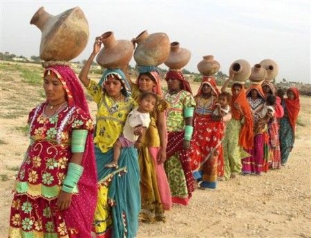
Figure 1.6 Thari women going out in search of water
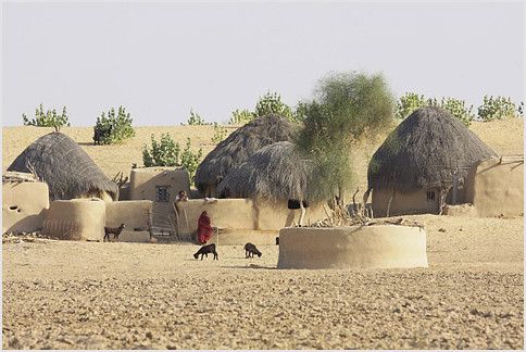
Figure 1.7 A Thari Village
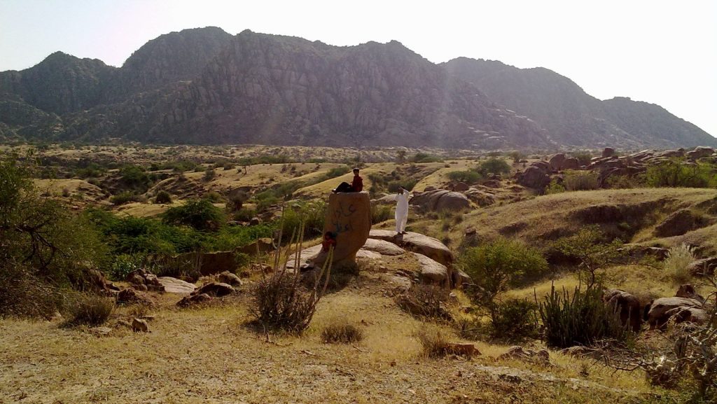
Figure 1.8 Karoonjhar Mountains
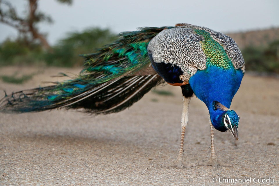
Figure 1.9 Peacock
[1] List of Reporting Bank Branches 2022, State Bank of Pakistan.
[2] Sindh Development Statistics 2021-22
[3] Health Profile Sindh by District 2022
[4] Herbal Treatment Centers
[5] Official Website: Sindh Police
[1] Table 17 Number of Commercial Poultry Farms and Number of Birds by Size of Flock
[2] “Physico-chemical characteristics of Nagar Parkar kaolin deposits, Thar Parkar district, Sindh, Pakistan”, University of Karachi
Environment and Biodiversity; Tharparkar District
Tharparkar district is located at the extreme Southeast corner of the province. It is one of the poorest and most underdeveloped districts in Sindh. The district is divided into 3 ecological zones: the Southeastern zone is hilly and rich in mineral deposits; the central area is Thar, which consists of sandy dunes; and the western zone (only a small portion) is the Barrage Area which is fertile.
Dug wells are the only sources of drinking water in the area. The underground water is largely brackish with limited locations with sweet water. The depth of ground water wells ranges from 18 meters (60 feet) in the Southwest to 92 meters (300 feet) in the Northeast.
Flora and Fauna; Tharparkar District
Since the district is situated in an arid zone, sweet water is scarce throughout Thar. Drought recurs, and usually rain occurs every third year. The soil is generally infertile, but becomes productive after rains. Because of severe wind erosion, the region is overblown with sand. Thus, vegetation consists mostly of stunted scrub and bush. The main natural ground cover is provided by grasses which are nutritive and a palatable fodder for livestock.
Flora
The vegetation of the district includes aak (Calotropis procera), khabar or peelu/tooth brush tree (Salvadora oleoides), babul/babur (Acacia arabica), boor or bui (Acura pseudo tomentosa), karir (Capparis aphylla), liar or lasura (Cordia rothii), dranu or khimp (Crotalaria-burhia), thuhar or leafless milk wedge (Euphorbia Caudicifolia), gangi or white cross berry (Grewia populifolia), magar booti or heart leaf indigo (Indigofera codifolia), khip (Leptadenia spartium), goji or box thorn (Lycium barbarum), kandi or khejri/loong tree (Prosopis spicigera), karvas (Sericostoma pauciflorum), thorny ber (Zizyphus rotundifolia), joyweed (Alternanthera nodiflora), pipevine (Aristolochia bracteata), booh or magbira (Aura tomentosa), sather, a type of asparagus (Asparagus jacquemontii), lumb (Aristida funiculata), hogweed or gadha-kand (Boerhaavia diffusa), bitter apple or desert gourd (Citrullus colocynthis), dharma khatri (Cleome brachycarpa), littoral bindweed (Cressa cretica), katjori or khavi grass (Cymbopogon jwarancusa), nagar motha or red nut sedge (Cyperus roundus), mert or desert bunchgrass (Panicum targidum), and hanzel or tooma or Meho (Acer palmatum).
Fauna
Mammals of the district include chinkara gazelle, desert fox, jackals, hyena, mongoose (endangered), wolf, Indian hedgehog (endangered), Indian desert wildcat (endangered), honey badger (endangered), small Indian civet, Indian wild ass (endangered), black rats (endangered), Indian gerbil (endangered), field rat, and squirrel (endangered).
The avifauna includes peacocks, black and grey partridges, barn owl, Indian scoops owl, Sindh nightjar, Indian nightjar, laughing dove, large hawk-cuckoo, and spotted sand grouse. Among water birds are the white stork, black ibis, great Indian bustard, houbara bustard, demoiselle crane, and flamingoes.
The reptiles of the district include khapar, Indian cobra, desert monitor, and spiny-tailed lizard.
Protected Wildlife Areas and Endangered Wildlife; Tharparkar District
Part of the Runn of Kutchh is a wildlife sanctuary and is part of the Great Thar Desert (some parts of which are also in Badin district). It is a seasonally marshy region (the word Runn/Rann means salt marsh). It is geographically the largest Ramsar site of all 10 identified Ramsar sites in Sindh, spread over 566,375 HA (320,463 Acres). In 1980, the Ramsar site was also declared a wildlife sanctuary by the Sindh government. The Runn of Kutchh is an integral part of the Great Runn of Kutchh (the part of the Runn of Kutchh that extends into India); it includes permanent saline marshes, coastal brackish lagoons, tidal mudflats, and estuarine habitats.
The site supports many species of birds and mammals, existence of which are locally and globally threatened. The site is also a wintering area for migratory water birds. It is estimated that this wetland regularly supports over 40,000 water birds annually. This area is known to be a breeding ground for flamingos (it supports more than 1% of the bio-geographical population of flamingoes) and is a staging ground for pelicans, cranes, storks and many species of waterfowl, including the great Indian bustard, houbara bustard, peregrine falcon, saker falcons, gyps vulture, and peacocks. The site supports mammals like blue bulls, chinkaras, desert wolves, desert cat, jungle cat, porcupine, desert hare, wolf, and pangolin. Lynx pelts have been sighted in the district regularly, even though living lynx are yet to have been spotted, indicating a hidden presence of lynx in the region.
The area has its unique identity among one of the 5 famous eco-ranges of Pakistan. Out of 7 routes for migratory birds in Central Asia, the Indus green route passes through the Thar Desert, making it an important zone from a wildlife-preservation perspective.