Share now
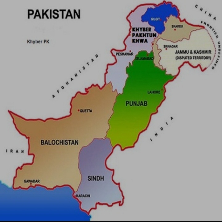
Map of Pakistan
IUCN GIS Map KP Districts

Khyber Pakhtunkhwa (KP) and its Districts

Flag of KPK
KPK Govt. Seal/ Coat of Arms
Khyber Pakhtunkhwa Districts
- Peshawar District Profile
- Abbottabad District Profile
- Bannu District Profile
- Battagram District Profile
- Buner District Profile
- Charsadda District Profile
- Chitral District Profile
- Dera Ismail Khan District Profile
- Lower Dir District Profile
- Upper Dir District Profile
- Hangu District Profile
- Haripur District Profile
- Karak District Profile
- Kohat District Profile
- Kohistan District Profile
- Lakki Marwat District Profile
- Malakand District Profile
- Mansehra District Profile
- Mardan District Profile
- Nowshera District Profile
- Shangla District Profile
- Swabi District Profile
- Swat District Profile
- Tank District Profile
- Torghar District Profile
- Bajaur Tribal Distyrict Ptofile
- Khyber Tribal District Profile
- Kurram Tribal District
- Mohmand Tribal District Profile
- North Waziristan Tribal District Profile
- Orakzai Tribal District Profile
- South Waziristan Tribal District Profile
Also visit: Sindh, Punjab, Baluchistan
Khyber Pakhtunkhwa Province Profile
Introduction/Geographical Details Khyber Pakhtunkhwa
The province that was known as North-West Frontier Province (NWFP) prior to 2010 was renamed under the 18th Amendment to the Constitution of Pakistan in 2010. It is now called the Khyber Pakhtunkhwa (KP) province. This province is located between 31° 4Ꞌ and 36° 57Ꞌ north latitudes, and 69° 16Ꞌ and 74° 7Ꞌ east longitudes. It is the northernmost province of Pakistan, and is bounded by Afghanistan in the west and north, Azad Kashmir and the Northern Areas (the Pakistani Administered areas of the Kashmir region) on the east and northeast, Punjab province on the southeast, and Balochistan province to the southwest. The former Federally Administered Tribal Areas (FATA) were located on the western boundary of KP along the Afghan border; these were semi-autonomous areas that were ethnically homogeneous with the province but were not politically connected to it.
Khyber Pakhtunkhwa at a Glance
| Name of Province | Khyber Pakhtunkhwa Province | ||
| Headquarters | Peshawar City | ||
| Population[1] | 35,525,047 persons | ||
| Area[2] | 101,741 km2 | ||
| Population Density[3] | 349.2 persons per km2 | ||
| Growth Rate[4] | 2.9% | ||
| Male Population[5] | 50.7% | ||
| Female Population[6] | 49.3% | ||
| Urban Population[7] | 16.5% | ||
| Administrative Units |
32[8] districts including PATAs:[9] 1. Abbottabad 2. Bannu 3. Battagram 4. Buner 5. Charsadda 6. Chitral (PATA) 7. Dera Ismail Khan 8. Hangu 9. Haripur 10. Karak 11. Kohat 12. Kohistan (PATA) 13. Lakki Marwat 14. Lower Dir (PATA) 15. Malakand (PATA) 16. Mansehra 17. Mardan 18. Nowshera 19. Peshawar 20. Shangla 21. Swabi 22. Swat (PATA) 23. Tank 24. Torghar 25. Upper Dir (PATA) 26. Bajaur 27. Khyber 28. Kurram 29. North Waziristan 30. Mohmand 31. Orakzai 32. South Waziristan |
||
| Important Cities | Peshawar, Abbottabad, Dir, Bannu, Balakot, Besham, Battagram, Daggar, Charsadda, Chitral, Dera Ismail Khan (D.I. Khan), Hangu, Haripur, Havelian, Kohat, Kulachi, Lakki Marwat, Latamber, Malakand, Mansehra, Mardan, Nowshera, Mastung, Alpuri, Swabi, Mingora, and Tank | ||
| Literacy Rate[10] | 53% | ||
| Male Literacy Rate[11] | 71% | ||
| Female Literacy Rate[12] | 35% | ||
| Major Economic Activity[13] | Agriculture, Livestock Breeding, Fishing & Hunting | 42.1% | |
| Community Services | 21.7% | ||
| Construction | 14.5% | ||
| Wholesale/ Retail, Hotel/ Restaurant | 9.4% | ||
| Manufacturing | 2.7% | ||
| Elementary Occupations | 2.3% | ||
| Transport, storage & communication | 5.7% | ||
| Others | 1.6% | ||
| Main Crops | Bajra, barley, gram, jowar, maize, maash, masoor, moong, wheat, cotton, rapeseed, mustard & canola, groundnut, sesanum, sugarbeet, guarseed, linseed, sunflower, sunn hemp, tobacco, and fodder | ||
| Major Fruits | Citrus, mango, banana, apple, guava, apricot, peach, pear, plums, grapes, pomegranate, dates, persimmon, melon, musk melon, watermelon, strawberry, mulberry, walnut, and cherry | ||
| Major Vegetables | Chilies, onion, potato, rice, sugarcane, tomato, coriander, turmeric, garlic, peas, turnips, carrots, cauliflower, cabbage, okra, brinjal, lotus root, and olives | ||
| Forest Area[14] | 1,882,015 HA[15] | ||
| Total Black Topped Roads[16] | 24,904.6 km | ||
| Shingle Roads[17] | 16,146.2 km | ||
| Electricity Generation[18] | Pakhtunkhwa Energy Development Organization (PEDO) looks after the development and generation of electricity in the province. In 2018-19, the total hydel power generation capacity in the province was 5,649 MW (owned and operated by Water and Power Development Authority or WAPDA), 354 MW (owned and operated by Independent Power Producers) | ||
| Telephone Exchanges[19] | 416 telephone exchanges, with 292,610 connections | ||
| Industrial Zones |
According to the official website of Khyber Pakhtunkhwa Economic Zones Development & Management Co., there are 9 main Industrial Estates and 10 Small Industries Estates in the province. The Industrial Estates are: · Hattar (Haripur) · Nowshera · Gadoon Amazai (Swabi) · Export Processing Zone (Risalpur) · Hyatabad Economic Zone · Dera Ismail Khan Economic Zone · Mohmand Economic Zone · Jalozai Economic Zone · Export Processing Zone, Risalpur Small Industries Estates are located in: · Kohat Road and Jamrud Road (Peshawar) · Mardan I and II (Mardan) · Mansehra · Khalabat (Haripur) · Kohat · Dera Ismail Khan · Bannu · Charsadda · Abbottabad In addition, there are training centers associated with the Industrial Estates. In all, there are 2,584[20] registered small, medium, and large enterprises out of which 2,222 units are operational and 362 units are closed |
||
| Major Industry (Running)[21] | Marble & Chips | 521 Units | |
| Flour Mills | 193 Units | ||
| Cement Based Industry | 134 Units | ||
| Plastic & Rubber | 107 Units | ||
| Ice Factories | 98 Units | ||
| Pharmacy | 80 Units | ||
| Engineering | 82 Units | ||
| Furniture | 61 Units | ||
| Silk | 44 Units | ||
| Household Size[22] | 8 persons per house | ||
| Houses with Piped Water[23] | 55.3% | ||
| Houses with Electricity[24] | 72.2% | ||
Table 1.1 KP Province at a Glance
[1] 2017 Census, (includes population of Ex. FATA)
[2] 1998 Census (added area of Ex. FATA)
[3] 2017 Census
[4] 2017 Census
[5] 2017 Census
[6] 2017 Census
[7] 2017 Census
[8] Includes 7 Agencies of Ex FATA now Districts in KP
[9] PATAs are Provincially Administered Tribal Areas. All PATAs were Princely States that acceded to Pakistan in 1947 and remained as Princely States till 1969. Swat, Dir, and Chitral were among the States that acceded to Pakistan. The area of Swat State is now divided into Swat, Buner, Shangla & Chitral and made into districts. Dir was merged into Khyber Pakhtunkhwa (then NWFP) and in 1996, it was divided into 2 districts: Upper and Lower Dir. PATAs are administered by the Chief Minister of KP but in name only; in most cases, all Pakistani Laws apply in these areas.
[10] Pakistan Social & Living Measurement Survey 2014-15 (Latest available)
[11] PSLM
[12] PSLM
[13] 1998 Census; 2017 Census data has not been released yet.
[14] Khyber Pakhtunkhwa Development Statistics 2018-19
[15] Land Utilization Statistics report 1,238,934 HA under forests
[16] Khyber Pakhtunkhwa Development Statistics 2018-19
[17] Khyber Pakhtunkhwa Development Statistics 2018-19
[18] State of Industry Report 2019 by National Electric Power Regulatory Authority (NEPRA).
[19] Khyber Pakhtunkhwa Development Statistics 2018-19
[20] Khyber Pakhtunkhwa Development Statistics 2018-19
[21] Khyber Pakhtunkhwa Development Statistics 2018-19; for details, please see section on Industry (Economic Activity)
[22] 1998 Census; 2017 Census data has not been released yet.
[23] 1998 Census; 2017 Census data has not been released yet.
[24] 1998 Census; 2017 Census data has not been released yet.