Share now
Map of Khyber Pakhtunkhwa

Map of Kohistan District

Khyber Pakhtunkhwa Districts
- Peshawar District Profile
- Abbottabad District Profile
- Bannu District Profile
- Battagram District Profile
- Buner District Profile
- Charsadda District Profile
- Chitral District Profile
- Dera Ismail Khan District Profile
- Lower Dir District Profile
- Upper Dir District Profile
- Hangu District Profile
- Haripur District Profile
- Karak District Profile
- Kohat District Profile
- Kohistan District Profile
- Lakki Marwat District Profile
- Malakand District Profile
- Mansehra District Profile
- Mardan District Profile
- Nowshera District Profile
- Shangla District Profile
- Swabi District Profile
- Swat District Profile
- Tank District Profile
- Torghar District Profile
- Bajaur Tribal Distyrict Ptofile
- Khyber Tribal District Profile
- Kurram Tribal District
- Mohmand Tribal District Profile
- North Waziristan Tribal District Profile
- Orakzai Tribal District Profile
- South Waziristan Tribal District Profile
Also visit: Sindh, Punjab, Baluchistan
Introduction/Geographical Details; Kohistan District
Kohistan district is located between 34° 54Ꞌ and 35° 52Ꞌ north latitudes, and 72° 43Ꞌ and 73° 57Ꞌ east longitudes. It is bounded on the north and northeast by Ghizer and Diamir districts of Gigit-Baltistan, on the southeast by Mansehra district, on the south by Batagram district, and on the west by Shangla and Swat districts.
Kohistan is a Persian word, literally meaning “Land of Mountains” (“koh” means “mountains” and “istan” means “land of”). The district has tall mountains and high peaks, which are intersected by numerous deep and narrow valleys. The Karakorum Highway runs along the River Indus up to the boundary of Kohistan and Diamer district (Gilgit-Baltistan).
Kohistan District at a Glance
| Name of District | Kohistan District (Indus Kohistan) | |
| Headquarters | Dasu Town | |
| Population[1] | 784,711 persons | |
| Area[2] | 7,492 km2 | |
| Population Density[3] | 102.5 persons/ km2 | |
| Growth Rate[4] | 2.7% | |
| Male Population[5] | 55.4% | |
| Female Population[6] | 44.6% | |
| Urban Population[7] | – | |
| Literacy Rate[8] | 24.0% | |
| Male Literacy Rate[9] | 41.0% | |
| Female Literacy Rate[10] | 5.0% | |
| Administrative Units |
04 Tehsils: 1. Dasu 2. Palas 3. Pattan 4. Kandia[11] |
|
| Important Cities/ Villages | Gabraal, Jijal, Dubair Bala, Dasu, Harban, Jalkot, Thoti, Karang, Kareen, Suput Valley, Palas, Shara Kot, and Bamgotta Gali | |
| Major Economic Activity[12] | Agriculture with its Allied Livestock Breeding & Fishing | 82% |
| Community, Social & Personal Services | 7.6% | |
| Construct | 3.8% | |
| Wholesale/Retail, Hotel/Restaurant | 3.1% | |
| Electricity, Gas & Water | 1.2% | |
| Others | 2.2% | |
| Main Crops | Maize, rice, wheat, barley, jowar, masoor, and red kidney beans | |
| Major Fruits | Walnuts, grapes, peach, plums, persimmon, apples, cherry, and strawberry | |
| Major Vegetables | Tomatoes. Other vegetables are grown vegetables for personal use only | |
| Forest (Area)[13] | 216,699 HA[14] | |
| Black Topped Roads[15] | 32.0 km | |
| Shingle Roads[16] | 249.6 km | |
| Electricity[17] | Peshawar Electric Supply Corporation (PESCO) looks after distribution and transmission of electricity in the district | |
| Telephone Exchanges[18] | 02 telephone exchanges, with 356 connections | |
| Industrial Zones[19] | There is no Industrial Estate and no Industry in the district. | |
| Major Industry[20] | There is no industry in the District. | |
| Household Size[21] | 6.4 persons per house | |
| Houses with Piped Water[22] | 9.1% | |
| Houses with Electricity[23] | 2.9% | |
Table 1.1 Kohistan District at a Glance
[1] 2017 Population Census
[2] 2017 Census
[3] 2017 Census
[4] 2017 Census
[5] 2017 Census
[6] 2017 Census
[7] 2017 Census
[8] Pakistan Social & Living Measurement Survey 2014-15 (PSLM) Latest available
[9] PSLM
[10] PSLM
[11] Notified as reconstituted in 2014
[12] 1998 Census 2017 Census data has not been made public yet.
[13] KP Development Statistics, 2018-10
[14] Forestry Statistics report 194,679 HA of forests
[15] KP Development Statistics, 2018-19
[16] KP Development Statistics, 2018-19
[17] KP Development Statistics, 2018-19
[18] KP Development Statistics, 2018-19
[19] KP Development Statistics, 2018-19
[20] KP Development Statistics, 2018-19
[21] 1998 Census; 2017 Census data has not been made public yet.
[22] 1998 Census; 2017 Census data has not been made public yet.
[23] 1998 Census; 2017 Census data has not been made public yet.
Brief History – Governmental Structure – Administrative Divisions – Historic/Heritage Sites and Tourist Attractions
Brief History of Kohistan District
Geographically, Kohistan stretches from the border with Azad Kashmir in the east to Swat in the west. The Indus River divides Kohistan into 2 parts: Hazara or Indus (east) Kohistan and Swat (west) Kohistan. The Indus Kohistan is also known as Abaseen Kohistan.
The Chilas district in Gilgit-Baltistan (GB) shares a border with KP’s Kohistan district. In 1950, the administration of GB was transferred to the Ministry of Kashmir Affairs. At that time, the area of Kohistan on the left bank of the Indus was unilaterally made a part of the North West Frontier Province (NWFP, now KP) and is now part of Kohistan district.[1]
The district was part of the Hazara Region, which included present-day Abbottabad, Battagram, Haripur, Mansehra, Kohistan, and Torghar districts. The early history is thus discussed in relevant chapters.
The areas now comprising the Kohistan district were part of what was called Yaghistan or “abode of rebels.” Kohistan district is, and was, the only passage between China and South East Asia. The area remained under constant attacks by Tibetans, Sikhs, and Hindus. This constant invasion resulted in one of the most distinctive societies and cultures in the region called Land of Rebellion or No-Man’s Land during British Rule.
This area is dominated by orthodox Sunni Muslims. Some early epigraphic evidence reveals the existence of small kingdoms in the region, but at some point in the medieval period, these kingdoms disappeared, and the different tribes established their own tribal system of political management, which the British Indian records characterize as “Republican”.[2] These political units had no kings, but tribal elders negotiated political relations with superior military powers. When these tribes moved into Gilgit, however, they accepted the authority of the local raja or king.
Kohistan has a rich local history as it has been a crossroads between Central, South, and Southwestern Asia. Predominantly inhabited by the Yashkun sub-tribe of the Dardic people since ancient times, Kohistan has been invaded and ruled by Persians, Greeks, Scythians, Kushans, Turks, Mughals, and the British. The Dardic tribe practiced Hinduism and Buddhism until the 15th century when they started embracing Islam, and now a majority of the population is Muslim.
Some claim that the people of this area are descendants of people from the armies of Alexander the Great, recruited from Iran, while some believe that the Kohistani people are Aryans. The Kohistani language is a derivation of the Sanskrit language.
The rock carvings or petroglyphs discovered by Karl Jettmar[3] in the Indus valley show that Chilas[4] was a frontier district of a Darada kingdom[5] between the 5th and the 8th centuries AD, with its seat in the Neelam/Kishanganga.[6]
These petroglyphs depict scenes of worship, merit in afterlife, and good luck on hunting trips. The inscriptions pertain to various historical periods, languages, races, religions, and civilizations.
In Shatial and Dasu (both villages located in Kohistan), rock inscriptions of Maharaja Ashoka (Mauryan Empire, 322-187 BC) have also been found, showing that the area was a part of the Mauryan Empire. After the fall of the Mauryan Empire, the White Huns (5th century AD) conquered the areas, and Buddhism was replaced by Hinduism. The area was then ruled by the Hindu Shahis from Kabul. The Hindu Shahi dynasty was overthrown by the forces of Mahmood Ghaznavi in the early 11th century. The scions of the Hindu Shahi fled towards Kashmir and Gilgit. Their followers were nobles and warriors, and were thus installed in privileged positions in these areas. These people were called “Shin”[7] or Kohistani people. Kohistan is also called “Shinkari” or “country of Shins”. They speak an Indo-Aryan language, called Shina.
During Arab invasions at the end of the 8th century, the Kabul Shahis (Hindu Shahis) based their defence on strongholds erected on inaccessible cliffs. They were thus able to repulse most of these attacks. Some of the Hindu traditions of the Hindu Shahi era are still practiced in some parts of Kohistan.[8]
In the early 11th century AD the Ghaznavid campaigns brought on the final collapse of the Hindu Shahi Kingdom. Swat was conquered by Mahmood Ghaznavi in 1048, and the populace converted to Islam.
The Turks ruled the area from 1399 to 1703. In 1703, the Swatis attacked the area, and after a strong battle, the entire region from Battagram to Mansehra was occupied by the Swatis. The Sikh invasions began in 1818 and by 1834 the northern areas had been captured by the Sikh General Hari Singh Nalwa. The areas remained under the Sikhs till the British annexation in 1849.
The Indus River cuts through the center of Kohistan from start to end, dividing the district in to Hazara Kohistan or Cis-Indus (east) and Swat Kohistan or Trans-Indus (west). The two areas have different histories and culture. Hazara Kohistan/ Cis-Indus was part of Hazara till the early 1950s, while the Swat Kohistan / Trans-Indus was part of the Swat State ruled by the Wali [ruler] of Swat. The two areas were merged in 1976 to form Kohistan district.
In 2014 Kohistan district was split into 2 districts: Upper Kohistan and Lower Kohistan.[9]
Governmental Structure; Kohistan district
At the Federal level, Kohistan district is allocated a set number of representatives in both the National Assembly and the Provincial Assembly:
- Number of seats in the National Assembly 1
- Number of seats in the Provincial Assembly 3
Under the Local Government Act District Kohistan has 1 District Council constituted by general seats, seats reserved for women, peasants/workers, youth, and non-Muslims as prescribed under the Khyber Pakhtunkhwa Local Government Act 2013. Kohistan District Council is composed of 39 general members, 13 women members, 2 peasants/worker members, 2 minority members, and 2 youth members.
Administrative Division; Kohistan district
The total area of the district is 7,492 km2 (1998 Census) and this is divided into 04 Tehsils as follows:
| Dassu | 11 Union Councils |
| Palas | 13 Union Councils |
| Kandia[10] | 04 Union Councils |
| Pattan | 10 Union Councils |
Table 1.2 Kohistan Administrative Divisions
[1] Extracted from Daily Dawn 30th May 2016
[2] History of Civilization of Central Asia Volume 4, p. 228 Edited by UNESCO
[3] Karl Jettmar was a German Scholar; Ahmad Hassan Dani, also known as the Father of Archaeology, and he both started exploring the rock carvings in 1980
[4] Chilas is officially part of Gilgit-Baltistan (Northern Areas) but it is disputed territory between Kohistan and Gilgit-Baltistan.
[5] Darada Kingdom has been identified with the Gilgit region in Kashmir
[6] The Oral History of the Daṛmá Lineage of Indus Kohistan by Ruth Laila Schmidt. This territory is part of the disputed Kasmir Occupied Territories
[7] Petroglyphs as Evidence for Religious Configurations by Karl Jettmar, 2008
[8] Extracted from Petroglyphs as Evidence for Religious Configurations by Karl Jettmar, 2008
[9] Since the district data has not been separated in Official government data at the time of printing, this volume treats the districts as one
[10] Newly created from Dassu Tehsil
Historic/Heritage Sites and Tourist Attractions; Kohistan district
There are no historical/heritage sites protected under Pakistan Laws in the district, but there are 2 areas which are important:
- Suput Valley;Kohistan district: situated on the southeastern side of Jalkot, it touches Kaghan and Naran of Mansehra district. It is snowbound from December to May. This valley consists of vast plains and is renowned for horse racing. It provides hiking and trekking spots
- Seo Mosque: located in Seo Dassu tehsil; Kohistan district, its wooden pillars and beams have beautiful pictures of flowers and geometrical patterns carved on them
Nearly the entire district is a majestic and naturally scenic tourism and picnic spot. Following are some of the more notable areas:
- Palas Valley; Kohistan district: located on the west bank of River Indus, it is one of the most beautiful valleys in Pakistan. It hosts nearly 140 different bird species, and is a paradise for bird lovers. It offers beautiful picnic spots near the river banks. The valley is famous for its rich wildlife and beautiful mountains
- Razaka (Seo, Dassu Tehsil): another beautiful tourist spot, accessible in the summer months

Figure 1.10 Palas Valley

Figure 1.11 Maheen Lake, a Glacier-fed Lake in Suput Valley
Topography of Kohistan District
Kohistan, as per its name, is the Land of Mountains. It is shaped like an irregular triangle, with its base in the north. The River Indus, flowing from northeast to southwest, divides the district approximately into two equal halves: Hazara or Indus Kohistan or Cis-Indus (east) and Swat Kohistan or Trans-Indus (west).
Kohistan is where the Karakorum, Hindu Kush, and the Himalayas meet, making it one of the unique mountain ecosystems of the world. The highest peaks of various spurs of the Hindu Kush Mountains, which separate Kohistan district from Swat district, are Falak Sar at a height of 5,918 m and the Mankial Peak at 5,726 m.
The narrow Indus Valley in Kohistan is flanked by 3 mountain ranges. The off-shoots of the Himalayas are on the left bank of the Indus, while the off-shoots of the Karakorum are on the right bank. The ranges reaching Kandia Valley from the north are considered to be the off-shoots of the Hindu Kush, and thus 3 of the highest mountain ranges of the world converge on/near Kohistan. These mountain ranges throw out spurs and are traversed by streams, thus producing a maze of valleys in the area.
The highest mountain in the district is about 17,000 (5,181.6 m) to 18,000 feet (5,486.4 m) high while many peaks range in height from 6,000 (1,828.8 m) to 7,000 feet (2,133.6 m).
Valleys in Kohistan district
Some of the main valleys of Kohistan district are
- Dassu
- Khandia
- Besham
- Pattan
- Sumar
- Komila
- Sazin
- Talil
- Kolai
- Palas
- Jalkot
- Harban
- Darel
- Basha
- Tangir
- Shatial
Mountain Peaks; Kohistan district
The highest peaks of the district include:
- Gunshar (4,950 m)
- Sukai Sar (4,437 m)
- Tazeem (5,100 m)
Mountain Passes; Kohistan district
Badavi Pass connects Dir with Kohistan.
Glaciers of Kohistan district
The Gorshai Glacier in Kohistan is at 4,725 m beneath an unnamed peak which is 5,254 m in elevation; this peak is south of the main Kohistan, Hindu Raj, and Hindu Kush Ranges.


Figure 1.3 Green Mountains, Palas Valley

Figure 1.4 Badawi Pass

Figure 1.5 Dubair Valley Kohistan
Rivers, Streams, and Lakes
The Indus is the main river flowing through the center of the district. It is fed by a few rivulets of perennial flow; these rivulets are snow-fed and hence swell during the summer when the snow melts. Important among them are the Dubair River, Pattan Nullah, Kayal Nullah, Moosha (rivulet), Zaid Khar Nullah, Kuz Jalkot Nullah, Barseen Nullah, Ashori Nullah, Kandia River, Shatial Nullah, and Harban Nullah.
In addition to these, there are numerous other streams, nullahs, and waterfalls which disappear or become a trickle in winter but become prominent in summers. There are a large number of glacier-fed lakes in the mountains. Maheen Lake and Sirkatha Lakes in Supat Valley are the important lakes.

Figure 1.6 A Waterfall, Kohistan District
Forests of Kohistan district
The following table shows the status of forests in Kohistan district as per KP Development Statistics 2018-19:
| Total Forest Area (Govt-owned) | 481,064 A | Resumed Land | – A |
| Reserved Forests | – A | Communal Forests | – A |
| Protected Forests | 214,701 A | Guzara Forests | 248,687 A |
| Unclassed Forests[1] | – A | Private Plantation | 17,676 A |
| Miscellaneous | – A | Linear Plantation | – km |
Table 1.3 Kohistan Forests
Kohistan district is home to Dry Temperate Forests of Pakistan. Dominant tree species include spruce (Picea smithianna), blue pine (Pinus Wallichiana) and deodar (Cedrus deodara) with an under-layer of neel (Indigofera gerardiana), dwarf elder (Sambucus ebulus), Himalayan sorbaria (Sorbaria tomentosa) and Plecanthrus rugosa.
The forests of Kohistan district can be divided into 5 types:[2]
- Shrub Oak Forests
- Pure Deodar Forests (grown at higher altitudes)
- Mixed Deodar, Kail, Fir, and Spruce Forests
- Mixed Fir and Spruce Forests
- Alpine Pastures
The shrub and oak forests are grown on the lower altitudes, from 4,000 1,219.2 m) to 5,500 feet (1,676.4 m). Deodar, kail, fir, and spruce grow at a higher altitude, ranging from 7,000 feet (2,133.6 m) to 11,000 feet (3,352.8 m); generally, elevations above 11,000 feet (2,133.6 m) are devoid of tree growth.
Kaigah Nullah Conservancy is a community-owned and protected game reserve in Kohistan district.
Soils of Kohistan district
Soils in valleys are deep and clayey, and shallow on mountain slopes. They are non-calcareous acid (pH 5.5-6.5) above 2,100 m altitudes and calcareous at lower altitudes.
Climate of Kohistan district
The climate of the district is warm in summer—except in some high areas where summers are also cool—and very cold in winter, when the temperatures fall below freezing, and there is heavy snowfall. The summer months are from May to September; winter starts in November and continues till March. The months of December, January, and February are very cold. The district can be divided into 3 climatic zones as follows:
- The high altitude peaks, where the snow starts falling during November and continues till end of March
- The deep and high mountain valleys, which are pleasant and temperate in summers and very cold in winter
- The lower regions/elevations along the River Indus, which are semi-arid. Heat/ cold radiation from bare rocks keep the areas hot in summers and very cold in winters
The Monsoons reach only the lower parts of Kohistan, and the rainfall is comparatively less than the neighbouring districts. Precipitation is greater in winter than in summer.
Seismic Activity/Seismicity of Kohistan district
Part of the district belongs to Zone 3 of the Seismic Zone Map of Pakistan, which is moderate to severe damage due to earthquakes, but some parts are situated in Zone 4 which is the severe damage zone. The 2005 earthquake caused tremendous damage in the district.
[1] Owned by Government
[2] District Profile Kohistan 1998; by Government of Pakistan
Population of Kohistan district
The following table shows the population of the district as per the 2017 Census:
| District |
Area km2 |
Population | Male% | Female% | Urban% | Growth Rate % | ||||||
| Kohistan District | 7,492 | 784,711 | 55.4 | 44.6 | – | 2.7% | ||||||
| Dassu Tehsil | 4,158 | 222,282 | ||||||||||
| Palas Tehsil[1] | – | 275,461 | ||||||||||
| Pattan Tehsil | – | 202,913 | ||||||||||
| Kandia Tehsil | Carved from Dassu Tehsil | 84,055 | ||||||||||
Table 1.4 Kohistan Population Statistics
Religious Composition; Kohistan district[2]
| Muslims | 99.8% |
| Christians | Negligible % |
| Hindus | Negligible % |
| Ahmadis | Negligible % |
| Scheduled Castes | Negligible % |
| Others | 0.2% |
Table 1.5 Kohistan Religions
Languages Spoken; Kohistan district[3]
| Urdu | 0.08% |
| Punjabi | Negligible % |
| Sindhi | 0.1% |
| Pushto | 3.9% |
| Balochi | Negligible % |
| Seraiki | Negligible % |
| Others[4] | 96% |
Table 1.6 Kohistan Languages
[1] Data for area of Palas, Pattan and Kandia tehsils is not available.
[2] 1998 Census; 2017 Census data has not been made public yet.
[3] Same as above.
[4] Other languages include Kohistani, Hindko, Gujri, and Majhi dialects of Punjabi language
Economic Activity – Economic Infrastructure
Economic Activity; Kohistan District
Agriculture with its allied livestock breeding and fisheries is the mainstay of the economy. The main industrial occupations of the district are:
- Agriculture with its allied livestock breeding and fisheries (82%)
- Construction (3.8%)
- Community, Social & Personal Services (7.6%)
- Wholesale/Retail, Hotel/Restaurant (3.1%)
- Electricity, Gas & Water (1.2%)
- Others (2.2%)
[1] 1998 Census; 2017 Census data has not been made public yet.
Land Use; Kohistan district
The following table shows the major land use statistics of the district (KP Development Statistics 2018-19):
| Total Area | 749,200 HA | Reported Area | 758,116 HA |
| Total Cultivated Area | 36,749 HA | Net Sown | 27,166 HA |
| Current Fallow | 9,583 HA | Uncultivated Area | 721,367 HA |
| Culturable waste | 117,249 HA | Forest area | 216,699 HA |
Table 1.7 Kohistan Land Use Statistics
Irrigation Network; Kohistan district
Generally, the area belongs to the Wet Mountains Agro-Ecological Zone of Pakistan and agriculture is mostly based on irrigation water supplied through privately-owned and dug water channels/ canals.
The following table shows the mode and area of irrigation in the district (KP Development Statistics 2018-19):
| Total Irrigated Area | 25,785 HA | Private Canal Irrigated | 25,785 HA |
| Government Canals | – HA | Wells | – HA |
| Others[1] | – HA | Tube Wells | – HA |
Table 1.10 Kohistan Irrigation Statistics
[1] Net Area Sown-Irrigated Area
Agriculture; Kohistan district
Since the entire district is mountainous with very limited plain areas, people practice agriculture on small terraces and have small land holdings. Generally, the district belongs to the Wet Mountains Agro-Ecological Zone of Pakistan.
Maize, rice, wheat, barley, jowar, masoor, red kidney beans, and poppy are the crops of the district.
Walnuts, grapes, peach, plums, persimmon, apples, cherry, and strawberry are the fruits grown in the district. Tomatoes, and peas are the only vegetables grown for commercial use; other vegetables are not grown on a commercial basis but people make small gardens and grow vegetables for personal use.
Livestock Breeding; Kohistan district
The following table shows the livestock population in Kohistan district as per Livestock Census 2006 (qtd. in KP Development Statistics 2018-19):
| Cattle | 250,910 Heads | Buffaloes | 51,163 Heads | Sheep | 196,510 Heads |
| Goats | 671,353 Heads | Camels | 314 Heads | Horses | 7,780 Heads |
| Asses | 29,900 Heads | Mules | 4,192 Heads |
Table 1.8 Kohistan Livestock Statistics
Chappar or Kohistani, and kaghani breeds of goat are native breeds of Kaghan Valley and also found in Kohistan district.
Poultry Farms; Kohistan district
The data for number of poultry farms in the district is not available in Table 17 (Number of Commercial Poultry Farms and Number of Birds by Size of Flock).
Fishing; Kohistan district
There is no commercial economic fishing activity in the district. Any fishing activity in the district is either for sport or for local consumption. The rivers flowing through the district carry clean water. Brown trout was introduced in the cold waters in 1962, and was successful. Sport fishing has helped the tourism industry in the area.
Bee Keeping/Apiary; Kohistan district
Honey is an important non-wood forest production of Khyber Pakhtunkhwa. The province offers ample opportunities for promotion of bee keeping. In Kohistan district, SMEDA (Small, Medium Enterprise Development Authority) is working in the district to help train and improve honey production.
Minerals and Mining; Kohistan district
At present, chromite is the only mineral being commercially mined in the district. There are known deposits of peridot in the district; these are just starting to be mined.
Oil and gas are not being explored in the district at present.

Figure 1.7 Peridot from Kohistan District
Industry and Manufacturing; Kohistan district
There are no Industrial Estates or any industry in the district.
Handicrafts; Kohistan district
The district’s economy is positively impacted by agriculture, livestock, and handicrafts production, as well as the carpet and rug industry, small businesses, local trade, and women’s activities such as embroidery, quilting, and tailoring.

Figure 1.8 An Embroidered Tobacco Pouch
Economic Infrastructure; Kohistan District
Kohistan district is connected via the Karakoram Highway (National Highway N-35) which passes through the district and connects it to other parts of Pakistan. The highway enters the district 8 km from Besham in Shangla district, and runs along the east bank of the Indus till Komila, from where it crosses the river and runs along the west bank till it crosses the district and enters Bhasha.
Road Statistics; Kohistan district
KP Development Statistics 2011-13, gives the road statistics of the district as:
| High Type | 32.0 km |
| Low Type | 249.0 km |
| Total | 281.0 km |
Table 1.9 Kohistan Road Statistics
Most of the roads in the district are low type roads, also known as shingle roads. Important roads of Kohistan district include:
- National Highway N-35 or Karakorum Highway
- Komila-Seo Road (low type)
- Jalkot Nullah Road (low type)
- Kandia Valley Road
- Kolai-Shamial Qillah Road
- Harban Nullah Road
- Zambeel-Gabral Road
- Dubair-Nilgai Road

Figure 1.12 Karakoram Highway
Rail and Airways; Kohistan district
The district is not linked with other districts through railway. The nearest railway station is in Abbottabad.
There is no airport whether commercial or military in the district. The nearest airport is the Abbottabad International Airport.
Radio Television; Kohistan district
There are no radio stations in the district.
Even though there is no TV station in the district, TV can be viewed through cable.
Telecommunications; Kohistan district
According to the KP Development Statistics 2018-19, there are 02 telephone exchanges in Kohistan district, with 356 connections. Cellular phone services with considerable coverage are also available.
Post Offices/ Courier Services; Kohistan district
There are 11 Post Offices in the district with no Head Office, but 04 Sub-Post Offices and 07 Branch Post Offices (KP Development Statistics 2018-19).
Banking/ Financial Institutions; Kohistan district
There are only 11 bank branches[1] in Kohistan district belonging to the following 2 banks:
- National Bank of Pakistan
- Allied Bank
- Askari Bank
- Alfalah Bank
- Askari Bank
- Muslim Commercial Bank
- UnitedvBank
- Zarai Taraqiati Bank
In all there are 10 branches of various Scheduled banks and 01 branch of Islamic bank in the District.
Electricity and Gas; Kohistan district
Peshawar Electric Supply Company (PESCO) looks after electricity distribution and transmission to all the districts of KP. PESCO networks own and maintain KP’s electricity distribution system via 132, 66, 33 KV sub-transmission lines and sub-stations and 11 KV and 440 V low tension lines with distribution transformers that deliver electricity to domestic and commercial users.
WAPDA is constructing small dams on rivers in the district for the production of electricity; these are located on Duber Khwar, Keyal Khwar, Spat Gah (a tributary of River Indus), and Chor Nullah Palas Valley.
[1] KP Development Statistics 2018-19
Educational Institutions; Kohistan district
The following table shows the number of Government Educational Institutions in the district as per KP Development Statistics 2018-19:
| Institution | Boys/Girls | Institution | Boys/Girls |
| Primary Schools | 481/142 | Middle Schools | 64/13 |
| High Schools | 29/02 | Higher Secondary Schools | 06/- |
| Mosque Schools | 35 | Degree Colleges | 02/- |
| Polytechnic Institutes | – | Commerce Colleges/Institutes | – |
| Vocational Centers | – | Private Primary Schools | 01 |
| Private Schools (Middle to Higher Secondary) | 12 | Engineering Colleges | – |
| Medical Colleges | – |
Table 1.11 Kohistan Educational Institutes
Healthcare Facilities; Kohistan district
The following table shows the Government Health Care Institutions in Kohistan district as per KP Development Statistics 2018-19:
| Institution | No./beds | Institution | No./beds |
| Hospitals | – | Dispensaries | 02/- |
| Rural health Centers | 04/32 | Basic Health Units | 33/- |
| Mother Child Health Centers | – | Sub-Health Centers | – |
| T.B. Clinics | 01/- | Leprosy Centers | 02/- |
| Private Hospitals | -/- | Private Medical Practitioners | – |
Table 1.12 Kohistan Health Institutes
Policing; Kohistan district
The District Police Officer (DPO) Kohistan is in-charge of policing Kohistan district. The DPO reports to the Deputy Inspector General Police, who in turn reports to the District Co-ordination Officer. In Kohistan district, there are 13 police stations.[1]
 Figure 1.13 River Indus in Kohistan

Figure 1.14 Dassu Bridge

Figure 1.15 Sirkatha Lake, Supat Valley

Figure 1.16 A Watermill in Palas Valley
[1] KP Development Statistics 2018-19
Environment and Biodiversity; Kohistan District
Since the industrial base of the district is very low, very little air pollution exists, and the quality of air is generally good in Kohistan district.
Flora and Fauna; Kohistan district
Kohistan is where the Hindu Kush, Karakorum and Himalayan mountain systems meet, and serve as a natural boundary for environmental regions. This uniqueness of the mountain systems results in rich flora and fauna, and provides a home to unique species such as the western tragopan pheasant and the snow leopard.
The district is also home to alpine meadows, dry temperate conifer forests, and sub-tropical pine forests.
Flora; Kohistan district
The flora of the alpine meadows consists of grasses and dwarf shrubs of various species. Deodar (Cedrus deodara) is the dominant tree species of dry temperate conifer forests, whereas chir pine (Pinus roxburghii) and kail (Pinus wallichiana) are the dominant species of trees in the sub-tropical pine forests.
Other vegetation species include walnut (Juglans regia), horse chestnut (Aesculus indica), Himalayan bird cherry (Prunus cornuta), Indian maple (Acer caesium) and sufaida or Himalayan poplar (Populus ciliate), poplar species (Populas spp.), oak species (Quercus spp.), fir (Abies pindrow), and spruce (Picea smithiana).
Undergrowth generally consists of snowball bush (Viburnum spp.), indigo or neel (Indigofera spp.), ner pattar (Skimmia laureola), Indian barberry (Berberis lyceum), rose (Rosa spp.), and rose family (Rubus spp.). Ground cover is thick, particularly in moist and cool localities. The ground flora consists of sorrel or spinach (Rumex spp.), clover (Trifolium spp.), wild strawberry (Fragaria vesca), cranes bill (Geranium spp.), Indian belladona (Atropa acuminate), and violet (Viola spp.).
Common shrubs are Persian ironwood (Parrotia spp.), honeysuckle (Lonicera spp.), species of rose (Sorbaria spp.) and silver leaf (Cotoneaster spp.). The ground flora consists of viola, fragaria, dicanthum, anemone spp. and ferns. Climbers like clematis and rosa are also found in some places.
Some medicinal plants of the district include saro or graveyard cyprus (Cupressus sempervirens L.), gojar or juniper or abhal (Juniperus communis L.), pencil juniper or chalai (Juniperus excelsa M.B), thuja or morepunkh (thuja orientalis), and toor amlook (Diospyros lotus L.).
Fauna; Kohistan district
The mammals found in the district include snow leopard, Himalayan ibex, brown bear, musk deer, black beer, yellow-throated martin, markhor, grey langoor, common leopard, monkeys, Himalayan grey goral, wolf, leopard cat, red fox, jackal, white-footed weasel, small Kashmir flying squirrel, giant red flying squirrel, porcupine, long-tailed marmot, varieties of rats and mice, burrowing voles, shrew, and at least 2 species of bats.
At least 140 varieties of avifauna are found in the district.[1] Some important birds include snow cock, snow partridge, golden marmot, golden eagle, khalij pheasants, Himalayan monals, koklas pheasant, speckled piculet, brown-fronted woodpecker, crested kingfisher, varieties of wood pigeon, white-throated needle tail, bearded vulture (very rare; seen only in winter), hen harrier, northern goshawk, long-legged buzzard, white-bellied redstart, Kashmir nuthatch (very rare), fire-capped tit, and white-cheeked tit.
Information on reptiles and amphibians is not available.
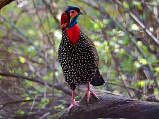
Figure 1.9 Western Tragopan in Palas Valley
Protected Wildlife Areas and Endangered Wildlife; Kohistan District
There is only one community-owned and protected game reserve in Kohistan district called Kaigah Nullah Conservancy. The critically endangered fauna include snow leopard, brown and black bear, markhor, flying squirrels, and grey langoors. Bearded vulture, Kashmir nuthatch, monal and koklas pheasants, and snow partridges are endangered avifauna of the district. The forests of the district are also disappearing very fast; they have now been given protected status and regeneration is in progress.
[1] District Profile Kohistan 1998 by Government of Pakistan