Share now
Map of FATA

Map of Khyber Tribal District

Khyber Pakhtunkhwa Districts
- Peshawar District Profile
- Abbottabad District Profile
- Bannu District Profile
- Battagram District Profile
- Buner District Profile
- Charsadda District Profile
- Chitral District Profile
- Dera Ismail Khan District Profile
- Lower Dir District Profile
- Upper Dir District Profile
- Hangu District Profile
- Haripur District Profile
- Karak District Profile
- Kohat District Profile
- Kohistan District Profile
- Lakki Marwat District Profile
- Malakand District Profile
- Mansehra District Profile
- Mardan District Profile
- Nowshera District Profile
- Shangla District Profile
- Swabi District Profile
- Swat District Profile
- Tank District Profile
- Torghar District Profile
- Bajaur Tribal Distyrict Ptofile
- Khyber Tribal District Profile
- Kurram Tribal District
- Mohmand Tribal District Profile
- North Waziristan Tribal District Profile
- Orakzai Tribal District Profile
- South Waziristan Tribal District Profile
Also visit: Sindh, Punjab, Baluchistan
Introduction/Geographical Details Khyber Tribal District (former Khyber Agency)
Khyber Agency (now Khyber Tribal District) is named after the world famous Khyber Pass, the most vital and important pass connecting Pakistan and Afghanistan. Khyber Tribal District (TD) is located between 33° 45′ to 34° 20′ north latitudes, and 70° 30′ to 71° 27′ east longitudes. The TD (Former Khyber Agency) is bounded on the northeast by Mohmand Agency (now a TD), on the northwest by Afghanistan, on the east by Peshawar, on the south by Orakzai Agency (now Tribal District) and on the west by Kurram Agency (now TD).
Khyber Tribal district at a Glance
| Name of TD | Khyber Tribal District | |
| Headquarters | Peshawar in winter and Landi Kotal in summer. | |
| Population[1] | 984,246 persons | |
| Area[2] | 2,576 km2 | |
| Population Density[3] | 382.1 persons/ km2. | |
| Growth Rate[4] | 3.14% | |
| Male Population[5] | 51.3% | |
| Female Population[6] | 48.7% | |
| Urban Population[7] | 9.9% | |
| Administrative Units |
04 Tehsils 1. Jamrud (2 tehsils) 2. Bara (1 tehsil) 3. Landi Kotal (1 tehsil) 4. Mula Gori Tehsil |
|
| Main Cities/ Towns | Jamrud, Bara, Landi Kotal, Tirah, Torkham, Shagai, Mullagori, Bazar, Serai Kandao, Ghaibi Baba, Maidan, and Dara Adam Khel | |
| Literacy Rate[8] | 45% | |
| Male Literacy Rate[9] | 72% | |
| Female Literacy Rate[10] | 15% | |
| Major Economic Activity[11] | Economic Activity figures for former FATA are not available, but subsistence level agriculture with its allied livestock breeding and fishing is the major employer. Other activities include small scale businesses, mining, and elementary occupations. Immigration to other districts in search of jobs to send remittances home is a major economic activity | |
| Main Crops | Wheat, maize, barley, sugarcane, rapeseed, mustard, soyabean, sunflower, sugarcane, moong, and jowar | |
| Major Fruits | Apples, apricots, peaches, grapes, almonds, plums, pears, citrus, guava, loquat, walnuts, peaches, ber, watermelon, and musk melon | |
| Major Vegetables | Okra, tomatoes, potatoes, pumpkin, cauliflower, turnips, carrots, spinach, cabbage, peas, bitter gourd, tinda, and brinjal | |
| Forests (Area)[12] | 2,083 HA[13] | |
| Black Topped Roads[14] | 663.0 km | |
| Shingle Roads[15] | 218.7.0 km | |
| Electricity | Tribal Agency Electricity Supply Corporation (TAESCO) looks after supply and transmission of electricity to Khyber TD. There are 6 grid stations in the TD. | |
| Telephone Exchanges[16] | 03 Telephone exchanges with 1,280 connections | |
| Major Industry[17] | No Industrial Estate but 537 small medium enterprises in the TD | |
| Industrial Units[18] | Marble Industry, Stone Crushing and Raw Marble | 326 Units |
| Cigarettes | 11 Units | |
| Food/Beverages | 22 Units | |
| Cloth and Silk Cloth | 57 Units | |
| Ice Factories | 12 Units | |
| Pipes | 19 Units | |
| Plastic Bags (i/c Shopping Bags), Goods and Plastic Pipes | 25 Units | |
| Polyester plus Household Goods | 41 Units | |
| 1Household Size[19] | 9.9 persons per house | |
| 1Houses With Piped Water[20] | 32.5% | |
| 1Houses With Electricity[21] | 72.3% | |
Table 1.1 Khyber TD at a Glance
[1] 2017 Census
[2] 2017 Census.
[3] 2017 Census
[4] 2017 Census
[5] 2017 Census
[6] 2017 Census
[7] 2017 Census
[8] Pakistan Social & Living Measurement Survey 2019-20
[9] Pakistan Social & Living Measurement Survey 2019-20
[10] Pakistan Social & Living Measurement Survey 2019-20
[11] FATA Sustainable Development Plan 2007-2015, Civil Secretariat FATA, Peshawar
[12] Khyber Pakhtunkhwa Development Statistics 2018-19.
[13] The KP Development Statistics do not record Forestry Statistics for the Tribal Districts.
[14] KP Development Statistics 2018-19
[15] KP Development Statistics 2018-19
[16] KP Development Statistics 2018-19
[17] FATA Development Authority, Industries Survey Report, 2010 (latest available)
[18] FATA Development Authority, Industries Survey Report, 2010 (latest available); for a detailed list of industries, please see the section on Industry
[19] 1998 Census; 2017 Census Data has not been released yet.
[20] 1998 Census; 2017 Census Data has not been released yet.
[21] 1998 Census; 2017 Census Data has not been released yet.
Brief History of the Tribal District – Governmental Structure – Administrative Divisions – Historic/ Heritage Sites
Brief History of Khyber Tribal District (TD)
The name Khyber[1] has an obscure and uncertain origin. One legend states that the word Khyber is a Hebrew word, and means “a fort or a castle”. This suggests that Khyber got its name because of its shape which resembles a fort as it is surrounded by lofty hills, as well as its strategic importance. Another legend suggests that Khyber might have received its name from a combination of villages named Khyber, situated on the road from Peshawar to Landi Kotal (also known as Lowergai), situated on both sides of the road between Katta Kushta and Lowargai (Landi Kotal). Yet another tale suggests that this place was named Khyber by the Pathans in 7th century AD to commemorate the victory of Hazrat Ali (RA) (cousin and son in law of Prophet Muhammad PBUH) over the Jews of Khyber near Madinah in Arabia (now Saudi Arabia).
The historic Khyber Pass, located in Khyber TD, has served as a corridor connecting the Indo-Pak Subcontinent with Afghanistan and Central Asia since antiquity. The strategic importance and location of this pass has given the people of Khyber and their land worldwide fame and recognition. It has remained a focus and an attraction for historians, writers, strategic analysts, and tourists. Trade caravans carrying articles for trade between the Indian subcontinent and Central Asia travelled through this pass, as well as most of the invading armies from Darius (Persia; 6th century BC) to Ahmad Shah Abdali (Afghanistan; 18th century AD). Some of these invading armies included the Aryans (1600 BC) from Central Asia, and the Persians led by Darius the Great in 6th century BC who conquered the region and made it a Persian Satrapy (province). Alexander the Great’s army led by the generals Hephaestion and Perdiccas (326 BC) travelled into the Subcontinent through this pass as well; however, Alexander himself took a northerly route. The Bactrians (descendants of the Greco-Bactrians; 200 BC to 10 AD), Scythians (150 BC-400 AD) and Parthians (12 BC-130 AD) all entered the Indo-Pak Subcontinent through this route. In the 1st century AD the Kushans set up a Central Asian Empire with Peshawar as its capital and the Khyber Pass area of former Khyber Agency became the imperial route for regular international traffic. It was during this period that Buddhism became a dominant religion in this region and Khyber became a part of the Gandhara Civilization. Stupas at Ali Masjid village and the Shpola stupa in Zarai village are ruins that indicate that the Khyber region was a part of the Gandhara Civilization.
The Kushans Dynasty were followed by the Sassanians in the 3rd century AD, which was an Iranian dynasty that preceded the advent of the Huns. As Islam spread in Central Asia, Muslim invaders from that region used Khyber Pass to enter the Subcontinent, like their predecessors.
Mahmood of Ghazni (from the direction of modern Afghanistan) used the Khyber route when he marched to encounter Jaipal (also spelled Jayapala) in the Peshawar valley. After the Ghaznavids, Shahabuddin Muhammad Ghori (1185 AD; also from the direction of modern Afghanistan) took control of this area as well as most of the Subcontinent, and established Muslim rule in Delhi after defeating Prithvi Raj (the Hindu ruler of Delhi) in 1192 AD. Amir Taimur (Tamerlane, 1398 AD) also used the Khyber Pass to enter the Subcontinent, and built a prison in the Khyber Pass, ruins of which are still present and visible from Michi Post. Tamerlane was followed by the founder of the Mughal Dynasty Zahiruddin Babar, who married the daughter of one of the Yousafzai Tribal Chiefs in order to maintain peace in the KP region, and establish control over the Tribal Areas. Both emperors Babar and Humayun each travelled the former Khyber Agency/ Pass more than once.
In March of 1739 AD Nadir Shah of Persia crossed the Khyber Pass on his way to Delhi and defeated the forces of the Mughal Emperor, Muhammad Shah, at Karnal (110 km north of Delhi). After this battle, during the negotiations that followed, Nadir Shah confiscated the famous Peacock Throne used by all the Mughal Emperors as well as other valuables belonging to them, and imposed a huge indemnity on the Mughal Emperor in exchange for allowing the Emperor to continue his rule. In November 1739, Nadir Shah was opposed by the Pathans while advancing through the Khyber Pass to attack Nasir Khan the Subedar (governor) of Kabul (under the Mughal Government). Nadir Shah led his cavalry through Bazar (a valley in Tirah) instead of the Khyber, thereby taking Nasir Khan by surprise and thus expelling him from the Jamrud area.
Ahmad Shah Abdali (1747-73), the founder of modern Afghanistan, also took the Khyber Pass route when entering the Subcontinent. He defeated the Marathas at Panipat in 1761 AD. Abdali’s grandson, Shah Zaman, also followed the Khyber routes on several occasions to conquer the Subcontinent and to trade. The Mughal Emperors attached great importance to the control of the Khyber Pass/ (former) Agency, but were singularly unsuccessful in their attempts to keep the route open. Then, as now, it was held by the Afridi Pathans, a race implacably hostile to the Mughals.
According to the Imperial Gazetteer of India
The first British advance into the Khyber was in 1839, when Captain Wade was deputed to conduct Shahzada Timur[2] to Kabul via Peshawar, while his father Shah Shuja was escorted by the army of the Indus via the Bolan Pass and Kandahar.
During the first Afghan War the Khyber was the scene of many skirmishes with the Afridis and of some disasters to the British. Captain Wade along with an army of 10,000 to 11,000 including the Sikh contingent, moved from Jamrud on July 22, 1839, to Gagri. Here he halted for a day and entrenched his position. On July 24 he marched to Lala China; on 25th he attacked Ali Masjid. (v.15 p.300)
The fort was evacuated by the Afridis on 27 July, 1839.
According to the Gandamak Treaty of 1879 which was signed between the British and Amir Yaqub Khan of Afghanistan, it was agreed that the British Government would retain the control of the Khyber Pass, and in pursuance of this agreement, allowances were fixed for the Afridis, aggregating Rs. 87,540 per annum. The management of the Pass was entrusted to the tribesmen through their Maliks (Chiefs), who undertook to guard the Pass. Some local Levies called Jezailchis (which later became the Khyber Rifles) were raised for escorting caravans through the Khyber Pass to ensure safe passage.
The Khyber Agency (now TD) witnessed fierce fighting during the Second Anglo-Afghan War (1878-80). After the war, the British occupied the Khyber Pass and established a piquet system to safeguard passage through it.
During the tribal uprising in 1897-98, the Afridis rose against the British and seized the Pass. They first captured Ali Masjid Fort, and after a few more days of fighting, conquered the cantonment of Landi Kotal. The British sent an expedition to Tirah under Sir W. Lockhart to control the “uprising”. The skirmishes between the British and the Afridis continued for some time, and ultimately an agreement to keep the Khyber Pass open for trade was signed in 1898. After this pact the British withdrew their armies from Ali Masjid and Landi Kotal.
The Khyber Rifles, a brigade of an informal army (also called the Jezailchis) was then raised by the British to keep the Khyber Pass secure. This semi-formal force was called Khasadars or Khyber Rifles, and its members were recruited from the local tribes. They were asked to carry their own rifles called Jezails (hence the name Jezailchi). The Khyber Pass did not witness peace for too long, however. In December 1899, the British regular army was withdrawn from the Khyber Pass/ (former) Agency and all guard duties were entrusted to the Khyber Rifles. For 6 years, there was almost complete peace and order, but in 1905 the Zakha Khels (a sub clan of the Afridi tribe) again started a guerilla war against the British, and in January 1908, Afridi tribes invaded Peshawar city. In February 1908, the British led armies against them and defeated them.
In 1919, the Hijrat and Khilafat movements[3] were launched to oppose British rule, and the Third Afghanistan War began. Amir Aman Ullah Khan (the Amir of Afghanistan from 1919 to 1929) launched an invasion on Thal (Kohat) Fort. This area is situated near the valley of Tirah. The Afridis were inspired by this invasion to launch a resistance to British rule; the Khyber Rifles (composed entirely of Afridis) refused to serve the British (to defend the fort of Thal) as a sign of non-confidence and as a protest against them. This regiment was thus dissolved. An agreement was reached between Amir Aman Ullah Khan and the British, through which Amir Aman Ullah Khan was recognized as King of Afghanistan. After this pact, the Khyber Rifles or Khasadars were reinstated.
On 23rd April 1930, the British opened fire on a crowd of protesting, unarmed, Muslims in Qissa Khwani Bazaar of Peshawar; some Afridis were among those who were killed. On 30th May, 1930 an Afridi army descended on the Bara Valley and entered villages of Peshawar district. In retaliation the British bombed the Khajuri plains of the Khyber Agency (now TD) and occupied it.
Khyber Agency (now TD) as an Administrative Unit came into being in 1879, with Major P. L. N. Cavagnari as the first Political Officer. In the year 1902, the post of Political Officer was converted into that of Political Agent, with Major G. Ross Kepper as the first Political Agent.
In a Jirga after Partition, in November 1947, the Afridis signed an agreement to join Pakistan.
Governmental Structure; Khyber TD
At the Federal level, Khyber Tribal district is allocated a set number of representatives in both the National Assembly and the Provincial Assembly:
- Number of seats in the National Assembly 2
- Number of seats in the Provincial Assembly 3
Under the Local Government Act, the Tribal District has 147 Councils, which include 130 Village and 17 neighbourhood Councils.
Administrative Divisions; Khyber Tribal district
Administratively, Khyber Tribal District is divided into 04 Tehsils and 147 Councils with 130 Village and 17 Neighbourhood Councils as follows:
- Bara Tehsil
- Jamrud Tehsil
- Landi Kotal Tehsil
- Mula Gori Tehsil
[1] Extracted from Etymology of the Word Khyber: Tracing the Origin of the Name of the Khyber Pass by Javed Iqbal
[2] Shahzada Timur was the eldest son and heir apparent of Shah Shuja of Afghanistan
[3] The Hijrat and Khilafat Movements were launched to protest British policies and for the restoration of the Ottoman Empire. The Ottoman Empire was an ally of the Germans in the First World War.
Historic/ Heritage Sites; Khyber Tribal District
Some of the important and ancient buildings[1] which need government protection for their preservation are:
- Jamrud Fort: this is, at present, under the control of Pakistan Army. The fort was built by Sikhs in 1836. The Afghan Army defeated Sikhs to capture the fort in 1837
- Bab-e-Khyber (door for entering Khyber Pass): built in 1963, Bab-e-Khyber has become a symbol of KP. An account of history starting from Alexander and the Aryans entering the area through the Pass has been provided at the site
- Michni Fort: located a few kilometers from Landi Kotal, the fort provides a view of the Pakistan-Afghanistan border. It has a historic value due to the war between the Afghans and the British in 1842, which is signified by a memorial post at the site. This fort is controlled by the Frontier Corps (FC)
- Shagai Fort: currently controlled by the Pakistan Army
- Ali Masjid: a famous fort also exists near the mosque
- Torkham Border: a historic check post with the last Pakistani Railway Station on the cross-country railway line
Other important archaeological sites[2] of the former Agency are:
- Sphola Stupa, which is located on the road to Afghanistan, dated between the 2nd and 5th centuries BC
- Tochi Valley: inscriptions dating back to 850 AD have been found in the valley. These inscriptions are in two languages: Arabic and Sarda, which was spoken during Hindu Shahi times (4th century to 870 AD)

Figure 1.4 Bab-e-Khyber

Figure 1.5 Inscriptions from Tochi Valley
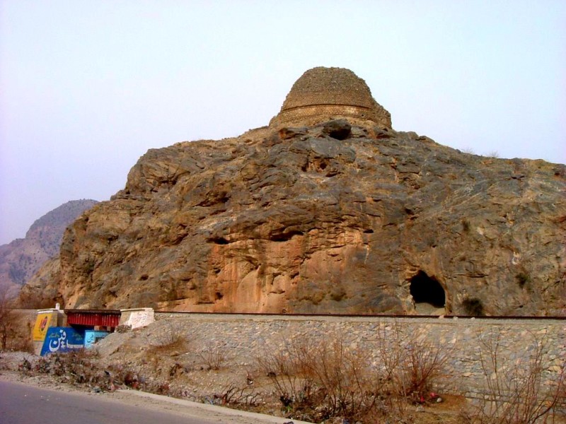
Figure 1.6 Sphola Buddhist Stupa

Figure 1.7 Ali Masjid

Figure 1.8 A Village in Chora Valley, Ali Masjid

Figure 1.9 Shagai Fort Khyber TD
Recreational Areas/ Tourist Attractions; Khyber TD
In addition to the historical places named above, other sites of interest to tourists are:
- Landi Kotal Bazaar (Khyber TD), where Chinese, Indian, Pakistani, and other South Asian goods are easily available
- Tirah Valley (Khyber TD): famed for scenic beauty, Tirah Valley’s beautiful valleys, hills, streams, and forests make it a prime tourist attraction. Its height from sea level is about 2,134 m (7,000 feet)
- Khyber Steam Safari (Khyber TD): this is a 27 km long railway line in Khyber going to Landi Kotal, with 34 tunnels and 92 bridges (a total of 3 km of tunnels). The railway line was completed in 1925
- Bara Spera Dam; Khyber TF

Figure 1.10 Jamrud Cricket Team
[1] Tourism Sector Report by FATA Development Authority
[2] Tourism Sector Report by FATA Development Authority; newer data is not available
Topography of Khyber Tribal District
Former Khyber Agency[1] is a barren and rugged mountainous terrain. It consists mostly of hilly tracks and mountains, with narrow strips of valleys. The Khyber Mountains form the last spurs of the Sufaid Koh (Koh-i-Sufaid or White Mountains, also called Spin Ghar mountains), as that range sinks down into the valley of the Kabul River.
The former Agency is located in a fork formed by the Sufaid Koh range at Witughar Peak. One prong of this fork forms the north and east border while the other prong forms the south and west border. The first (north) prong of this fork runs eastward for nearly 96 km (60 miles) and falls into the Peshawar valley around the Jamrud and Khajuri areas, having thrown out the spurs that contain and divide the Bazar valley, Khyber valley, and Shalman valley. It then runs south and east, forming the watershed between Peshawar and Kohat valleys, connecting the Kohat Pass with Adam Khel Territory (Kohat Sub Division)
The other prong (south) starting from the same point of the fork on Withugar Peak runs first due south along the crest of the ridge bordering Tirah on the west via the Torghar, Kharaghar, and Kahughar peaks. It then turns eastward, and, still skirting Tirah, follows the crest of the ridge separating Tirah Valley from the Orakzai valley.
Lacha Ghar, Karagah Ghar, Surghar, Torghar, Morgah, and Kalauch are some of the mountains located in the Former Agency. Generally, the hills of this TD are barren.
Valleys of Khyber TD
Interspersed between these hills are the valleys which are inhabited. These valleys are irrigated by intermittent rains and snow melt, and cultivated for food and fodder. Some of the valleys are the Tirah Valley, Ali Masjid Valley, Jamrud Valley, Landi Kotal, Chora Valley, Bazar Valley, Khajuri Plains, Maidan Valley, and Rajgal Valley.
Figure 1.3 Tirah Valley in Khyber TD
Mountain Peaks in Khyber TD
The known mountains and peaks of the Former Agency are Lakasar, Naraighar, Takhtakai, Torghar, Ganjai Murgha, Rotaz, Luzaka, Sandapal, Surghar, and Mala Ghar. These peaks have heights ranging from 1,829 m to 3,048 m (6,000 to 10,000 feet).
Mountain Passes of Khyber TD
Besides Khyber Pass, other notable mountain passes in the Former Agency are Ilacha Kandao, and Saliara Kandao.
Rivers, Streams, and Lakes; Khyber TD
Two main rivers flow in the TD: the Bara River and the River Kabul. The Bara River flows in the southern part of the TD, whereas the Kabul River makes the northern boundary between Khyber and Mohmand Agencies. Other notable rivers are the Chora River flowing in the heart of the TD and the Jabba Khwar which passes through Jamrud Valley. Other smaller intermittent streams in the TD are Oial Khwar, Kati Nao Khwar, Taoda Oba Khwar, Pahari Khwar, and Khauno Khwar. Some springs in the TD are Samsai Oba, Rahim Mena China, Orghar China, Karappo Oba, Taoda Oba, Khwano Khula, and Shilman Khula.
Some water ponds/ lakes of the TD include Manzai Talao, Spingiri Nikka Talao, Mohibullah Talao, and Katakani Talao.
Forests of Khyber TD
The major forested areas[2] in Khyber TD are the forests in Maidan Valley, Bazar Valley, the area near the Pak-Afghan border, and the area near the border of Khyber and Orakzai Agencies. Lacha Dhar, Karagah Ghar, Surghar, and Tor Ghar, Morgah as well as the Kalauch ranges are important habitats for forests of the TD. The following floral species are indigenous to the Khyber TD.
- Prosopis or Jand (Prosopis juliflora)
- Phulai (Acacia modesta)
- Kao (Olea cuspidata)
- Ber (Ziziphus; Ziziphus numularia)
- Gurgura (Monotheca boxifolia)
- Blue Pine (Pinus wallichiana)
- Cedar (Cedrus deodara)
- Oak (Quercus incana)
- Sanatha (Dodonea viscosa)
The following table shows the status of forests as per FATA Development Statistics 2013-14 (The KP Development Statistics do not record the forestry Statistics of The TDs):
| Total Forest Area | 69,497 A | Irrigated Plantation | 49,358 A |
| Natural Forests | 20,000 A | Linear Plantation | 183 km |
Table 1.3 Khyber TD Forests
Soils in Khyber TD
The soils of the TD are mainly from the local weathering of bedrock, deposited by streams and rivers. Landforms in the area are varied, and include piedmont plains, valleys, gravel fans, rough broken land, and gullied land. Level areas are loamy, while lowlands are calcareous.
Climate; Khyber TD
The TD has extreme climate, with both severe winter and summer seasons. May, June, July, and August are the hot months. The mean maximum and minimum temperatures during the month of June (which is the hottest month) are 40 °C and 26 °C. The winter starts in November, and continues till April; December, January, and February are the coldest months. The mean maximum and minimum temperatures during January, which is the coldest month, are 18 °C and 4 °C respectively.
The average yearly rainfall is 400 mm.
Seismic Activity/Seismicity; Khyber TD
The TD belongs to Zone 2B of the Seismic Zone Map of Pakistan, which means minor to moderate damage due to earthquakes
[1] Extracted from Socio Economic Profile of Khyber Agency, USAID, 1993
[2] Socio Economic Profile of Khyber Agency, by Technical Support and Planning Unit (TSPU), Tribal Areas Development Project (TADP) and Rural Development Division for USAID
Population of Khyber TD
The following table shows the population of Khyber TD as per the 2017 census:
| Tribal district |
Area km2 |
Population | Male% | Female% |
Urban % |
Growth Rate % |
| Khyber TD | 2,576 | 984,246 | 51.3 | 48.7 | 9.9 | 3.14 |
| Bara Tehsil | 1,430 | 443,449 | ||||
| Jamrud Tehsil | 311 | 227,557 | ||||
| Landi Kotal | 679 | 273,052 | ||||
| Mula Gori Tehsil | 156 | 40,188 |
Table 1.4 Khyber TD Population Statistics
Religions in Khyber TD[1]
| Muslims | 99.7% |
| Christians | 0.1% |
| Hindus | Negligible % |
| Ahmadis | 0.1% |
| Scheduled Casts | negligible% |
| Others | 0.1% |
Table 1.5 Khyber TD Religions
Languages, Khyber TD[2]
| Urdu | 0.1% |
| Punjabi | 0.3% |
| Sindhi | Negligible % |
| Pushto | 99.6% |
| Balochi | Negligible % |
| Seraiki | Negligible % |
| Others | Negligible % |
Table 1.6 Khyber TD Languages
[1] 1998 Census; 2017 Census Data has not been made public.
[2] 1998 Census; 2017 Census Data has not been made public.
Economic Activity – Economic Infrastructure
Economic Activity; Khyber Tribal District
The local economy[1] is largely pastoral, with agriculture being practiced in a few fertile valleys. Most people are engaged in subsistence level agriculture and livestock breeding, as well as small businesses conducted locally. People mostly seek employment in other parts of the country or outside Pakistan.
[1] Employment by Industry numbers for FATA are not available, and have not been included here.
Land Use; Khyber Tribal district
The following table shows the main land use statistics of Khyber TD as per KP Development Statistics 2018-19:
| Total Area | 257,600 HA | Reported Area | 257,676 HA |
| Total Cultivated Area | 24,353 HA | Net Sown | 17,618 HA |
| Current Fallow | 6,735 HA | Uncultivated Area | 233,323 HA |
| Culturable Waste | 48,825 HA | Forest Area | 2,083 HA |
Table 1.7 Khyber TD Land Use Statistics
Agriculture; Khyber TD
The crops of the former Agency include wheat, maize, barley, sugarcane, rapeseed, mustard, soyabean, sunflower, sugarcane, moong, and jowar.
Fruits grown include apples, apricots, peaches, grapes, almonds, plums, pears, citrus, guava, loquat, walnuts, peaches, ber, watermelon, and musk melon.
Vegetable produce of the Former Agency includes okra, tomatoes, potatoes, pumpkin, cauliflower, turnips, carrots, spinach, cabbage, peas, bitter gourd, tinda, and brinjal.
Livestock Breeding; Khyber TD
The following table shows the livestock statistics in Khyber TD as per Livestock Census 2006 (qtd. in KP Development Statistics 2013-14[1]):
| Cattle | 155,817 Heads | Buffalos | 10,274 Heads | Sheep | 190,478 Heads |
| Goats | 529,147 Heads | Camels | 826 Heads | Horses | 15,092 Heads |
| Asses | 31,448 Heads | Mules | 28,216 Heads |
Table 1.8 Khyber TD Livestock Statistics
Balki, and Tirah or Afridi sheep, as well as maya breed of camel are the indigenous breeds of cattle of the TD.
Poultry Farms; Khyber TD
Backyard poultry farming[2] is part and parcel of Pakistan’s rural economy. Conditions for poultry farming are particularly favourable in the upper reaches of all Agencies in FATA, with Khyber and Kurram Agencies currently home to the largest number of poultry farms. Around 96 commercial poultry farms[3] are operating in Khyber Agency (Now TD).
Fishing; Khyber TD
The rivers and streams[4] that traverse the region harbour a variety of fish, depending on the climatic regime. Cold waters in the upper reaches are suitable for trout, while warmer waters in the lower reaches favour carp. These aquatic resources are ideally suited for the development of fisheries.
Fishing is carried out in the streams, rivers, and lakes, but most of this fish is consumed locally.
Bee Keeping/Api Culture; Khyber Tribal District
The Government of Pakistan is promoting the bee keeping/honey production industry in the TDs to help create employment and for income generation purposes.
Minerals and Mining; Khyber TD
The mountains[5] of the Tribal Areas yield a variety of minerals, ranging from marble and granite to copper and gold. Since mineral extraction depends heavily on labour, the mining industry can serve as an immediate means of creating employment in the region. Considering the reserves that have already been identified, the sector has the potential of becoming a major employer in the long term.
The mineral resources of Khyber TD include marble, limestone, soapstone, barite, and fluorite. These minerals are being mined commercially. Mineral potential includes dolomite, calcites, mica, and epidote. Gemstones include Quartz, Xenotime, and Bastnaesite.
Irrigation Network; Khyber Tribal district
The main sources of irrigation[1] in the TD are the Bara River, Jabba Khwar, and the Chora River. Other smaller springs and streams also provide water for irrigation purposes. There are some surface canals as well. The following table shows the mode of irrigation system used[2] and area irrigated by each:
| Total Irrigated Area | 11,041 HA | Government Canal Irrigated | 8,510 HA |
| Tube Wells | 1,850 HA | Private Canals Irrigated | – HA |
| Wells | 200 HA | Others (Lift Pumps etc.) | 481 HA |
Table 1.11 Khyber TD Irrigation Statistics
One small dam called Zao Small Dam was completed in 2014; this dam irrigates 250 acres of land in the Bara Tehsil.
[1] Data on agro-ecological zones of TDs is not available
[2] FATA Development Statistics 2013-14; KP development statistics 2018-19 does not record data for TD
Industry and Manufacturing; Khyber TD
There are no industrial zones/ estates in Khyber Agency (now TD), but there are 106 industrial units working in the region. According to the FATA Development Authority[6] there are 537 small industries working in the district. The following table shows the type and number of industrial units in the region:
| Type of Industry | No. of Units | Type of Industry | No. of Units |
| Achaar industry | 04 | Bags/ Plastic Bags | 10 |
| Blades | 08 | Bardana | 01 |
| Bottles | 01 | Cable | 02 |
| Cement Blocks | 02 | Chips | 06 |
| Cigarettes | 11 | Cloth | 53 |
| Cold Drinks | 01 | Cots/ beds | 01 |
| Stone Crushing | 11 | Consumer Goods | 02 |
| Dana | 14 | Distilled Water | 01 |
| Soups | 01 | Fertilizer | 01 |
| Filter | 01 | Oil | 01 |
| Flour Mills | 01 | Ghee/oil | 01 |
| Household goods | 04 | Ice Factories | 12 |
| Gates | 01 | Potato Chips | 01 |
| Marble Crushing | 214 | Marble Tiles | 52 |
| Safety Matches | 05 | Hardware | 02 |
| Paper | 02 | Pipes/ Plastic Pipes | 20 |
| Plastic Goods | 15 | Polyester Goods | 02 |
| Pots and pans | 07 | Talcum Powder | 04 |
| Propylene Goods | 02 | Raw Marble | 35 |
| Salt | 03 | Steel Scrap | 01 |
| Shoes | 01 | Soaps | 09 |
| Silk Cloth | 04 | Soda Water | 02 |
Table 1.9 Khyber TD Industries
Handicrafts; Khyber TD
Household items made of marble are the main handicrafts of the TD; other items include different types of embroidery on clothes.
[1] KP Development Statistics 2018-19 do not record data for TDs
[2] Sustainable Development Plan 2007-15, Civil Secretariat FATA
[3] Table #17, No. of Commercial Poultry Farms and Number of Birds by Size in Pakistan
[4] Sustainable Development Plan 2007-15, Civil Secretariat FATA
Economic Infrastructure; Khyber Tribal District
The banks of the streams in Khyber TD are honeycombed with cave dwellings. There are numerous stone towers, but no large or walled villages. The houses are three-storied with lapelled parapets. In most of the houses, cattle are housed on the ground floor, while the dwelling place is on the top, and the center is barren.
Road construction is the critical foundation for further development in FATA, as roads provide access to markets and allow the transportation of raw materials while providing greater security because they facilitate security and military forces to rapidly respond to crises.
Road Statistics Khyber Tribal District
There are two types of roads in Khyber TD: High type and Low type. The following table shows the Road Statistics as per KP Development Statistics 2018-19:
| High Type | 663.0 km |
| Low Type | 218.7 km |
| Total | 881.7 km |
Table 1.10 Khyber TD Road Statistics
Important roads of the TD are:
- National Highway N-5 passes through the TD, connecting Peshawar to Torkham
- Landi Kotal-Mullagori Road
- Frontier Roads connecting N-5 at Jamrud with Bara Tehsil and onwards to Peshwar, and Kohat via Mattani
- Bara Tehsil-Dogra Fort Salop Road
- Khyber-Orakzai Road
Rail and Airways; Khyber TD
The Khyber Pass train connects Pakistan with Kabul in Afghanistan, but this train route was closed in 2006, when the tracks were washed away during heavy Monsoon rains. There are 2 railway stations in Khyber TD; these are the Landi Kotal Railway Station and Landi Khana Railway Station.
There is no airport in the TD. The nearest airport is Peshawar Airport.
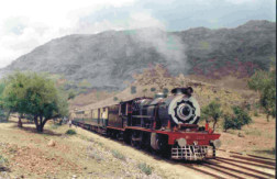
Figure 1.11 Khyber Steam Safari

Figure 1.12 A Railway Bridge, Khyber TDy
Radio and Television; Khyber TD
There are no privately-owned or public radio stations in any TD. TV can be viewed via cable.
Telecommunications; Khyber TD
Telecommunications is one of the important components for communication. According to KP Development Statistics 2018-19, there are 03 telephone exchanges in Khyber TD. These exchanges provide 1,280 connections in the TD. In addition, private cellular companies provide their services in the region.
Post Offices/ Courier Services; Khyber TD
Pakistan Post is the main enterprise looking after a wide range of postal products and public services in Pakistan. Pakistan Post is providing a variety of services on behalf of many federal and provincial government departments.
In addition to the Pakistan Post Urgent Mail Service, there are a number of courier services working in the province.
According to KP Development Statistics 2018-19, there are 20 Post Offices in Khyber TD which include 03 sub and 17 branch offices.
Banking/ Financial Institutions; Khyber TD
In all, there are 08 bank branches[1] in the TD. These are
- Habib Bank Ltd.
- National Bank Pakistan Ltd.
- The Bank of Khyber Ltd.
- Al Falah Islamic Banking Branch
Energy Sources; Khyber TD
TESCO (Tribal Electricity Supply Corporation) supplies and distributes electricity in FATA. Sarhad Hydel Development Organization (SHYDO), and Water and Power Development Authority (WAPDA) are responsible for power generation in the province as well. There are 3 grid stations, each of 132 KV capacity, located in Landi Kotal, Bara, and Jamrud. Gas for domestic use[2] is not available.
[1] State Bank of Pakistan; KP Development Statistics do not record data for TDs
[2] Socio Economic Profile Bajaur Agency, by Technical Support Unit (TSU), Tribal Areas Development Project and Rural Development Division for Planning and Development Department, Government of KP
[5] Sustainable Development Plan 2007-15, Civil Secretariat FATA
[6] FATA Development Authority report on Survey-Enumeration of Industries, Service Sector Entities, Labour Force, and Identifying Constraints in FATA, October 2010
Educational Institutions; Khyber TD
Total literacy rate of Khyber TD is 46%. Male literacy rate is 72%, whereas female literacy is 15%. The following table shows the number of government educational institutions in Khyber TD (KP Development Statistics 2018-19):
| Institution | Boys/Girls | Institution | Boys/Girls |
| Primary Schools | 297/270 | Mosque Schools | 15 |
| Middle Schools | 30/24 | High Schools | 32/07 |
| Higher Secondary | 02/02 | Community Schools | 126 |
| Degree Colleges | 03/01 | Universities | – |
| Govt. Elementary College | 02 | Agricultural Universities | – |
| Commercial Training | 01 | Polytechnics | 02 |
| Cadet Colleges | – | Vocational Training Inst. | – |
Table 1.12 Khyber TD Educational Institutes: Government
Healthcare Facilities; Khyber TD
The following table shows the Government Health Care Institutions in Khyber TD as per KP Development Statistics 2018-19:
| Institution | No/Beds | Institution | No./Beds |
| Hospitals | 05/190 | Dispensaries | 26/- |
| Rural Health Centers | – | Basic Health Units | 13/- |
| Sub-Health Centers | – | Mother Child Health Centers | 02 |
| TB Clinics | 04/- | Private Hospitals | -/- |
| Private Medical Practitioners | – |
Table 1.14 Khyber TD Health Institutes
Policing; Khyber TD
The District Police Officer (DPO) is directly responsible to the District Mayor for public safety. The Police Department is headed by the Senior Superintendent of Police (SSP). The SSP supervises and controls the police force in maintaining law and order, and investigation of cases of a criminal nature. The Police Department operates under the Police Rules. There are no Police Stations in the District.
The Levy Force, Khassadars and the Scout Troops operating in the erstwhile Khyber Agency have been absorbed into the KP Police as per the KP Levies Force Bill 2019.
Environment and Biodiversity; Khyber Tribal District
The ambient air quality in the TD is excellent due to minimal sources of air emissions. The only source of impact on the quality of the ambient air is the rare vehicular traffic on the roads, which causes some dust emissions whose effect is localized. The main pollutants from vehicle exhaust are lead, particulate matter, carbon monoxide, sulphur dioxide, and nitrogen oxides. These emissions temporarily affect the air quality in the immediate vicinity of the roads.
Flora and Fauna; Khyber TD
Flora; Khyber TD
The flora of the TD includes prosopis or kikar (Prosopis juliflora), phulai (Acacia modesta), kao (Olea cuspidata), ber (Ziziphus; Ziziphus numularia), gurgura (Monotheca boxifolia), blue pine (Pinus wallichiana), cedar (Cedrus deodara), oak (Quercus incana), sanatha (Dodonea viscosa), eucalyptus (Eucalyptus camaldulensis), poplar (Populas sp), mulberry or toot (Morus alba), shisham (Dalbergio sissoo), and farash (Tamarix articulate).
Pakistan has a rich history of folk use of plants for medicinal purposes. According to Ethnobotanical Assessment of The Medicinal Flora of Khyber Agency Pakistan by Kashif Ali, Muhammad Shuaib, Zahid Hussain, Wasim Sajjad, Fawad Ali, and Muhammad Fazil, there are 30 plant species belonging to 23 different families that have been documented as trees/ plants being used for medicinal purposes in Khyber TD. Some of these plants include dhoda (Papaver somniferum sp), nakhtar (Pinus roxburghii), ispaghol (Plantago ianceolata), mushk-e-bala (Valeriana jatamansi), and shandai (Melia azardarach).
Fauna; Khyber TD
Most of the fauna that still exists in the TD found in the Tirah Valley; these include mountain sheep, black bear, leopard, jackals, hyena, fox, wolf, and monkey. The avifauna includes a variety of pheasants, cranes, egrets, and Himalayan Monal pheasant. Reptiles and amphibians include varieties of toads, geckos, lizards, and skinks.
Protected Wildlife Areas and Endangered Wildlife; Khyber Tribal District
At present, there are no wildlife protected areas in the former FATA Region, but the GoKP has passed a law for the creation of protected areas in the region.
Endangered wildlife of the region includes nearly all of the mammals and birds found in the TD.