Share now
Map of Khyber Pakhtunkhwa

Map of Battagram District

Khyber Pakhtunkhwa Districts
- Peshawar District Profile
- Abbottabad District Profile
- Bannu District Profile
- Battagram District Profile
- Buner District Profile
- Charsadda District Profile
- Chitral District Profile
- Dera Ismail Khan District Profile
- Lower Dir District Profile
- Upper Dir District Profile
- Hangu District Profile
- Haripur District Profile
- Karak District Profile
- Kohat District Profile
- Kohistan District Profile
- Lakki Marwat District Profile
- Malakand District Profile
- Mansehra District Profile
- Mardan District Profile
- Nowshera District Profile
- Shangla District Profile
- Swabi District Profile
- Swat District Profile
- Tank District Profile
- Torghar District Profile
- Bajaur Tribal Distyrict Ptofile
- Khyber Tribal District Profile
- Kurram Tribal District
- Mohmand Tribal District Profile
- North Waziristan Tribal District Profile
- Orakzai Tribal District Profile
- South Waziristan Tribal District Profile
Also visit: Sindh, Punjab, Baluchistan
Introduction/Geographical Details; Battagram district
The district is located between 34° 57Ꞌ to 34° 33Ꞌ north latitudes, and 72° 57Ꞌ to 71° 31Ꞌ east longitudes. District Battagram (also spelled Batagram) is bounded by the Kohistan Valley in the north, Mansehra district in the east, the Kala Dhaka Tribal Area on the south, and Shangla district of Malakand Division on the west.
Battagram District at a Glance
| Name of District | Battagram District | ||
| Headquarters | Battagram Town | ||
| Population[1] | 476,612 persons | ||
| Area[2] | 1,301 km2 | ||
| Population Density[3] | 351.6 persons/ km2 | ||
| Growth Rate[4] | 2.3% | ||
| Male Population[5] | 50.0% | ||
| Female Population[6] | 50.0% | ||
| Urban Population[7] | NA | ||
| Administrative Units | 02 Tehsils:
1. Battagram 2. Allai |
||
| Main Towns/ Villages | No cities, but major villages include Thahkot, Peshora, Allai, Battagram, Kuza Banda, and Shumlai | ||
| Literacy Rate[8] | 33% | ||
| Male Literacy Rate[9] | 53% | ||
| Female Literacy Rate[10] | 16% | ||
| Major Economic Activity[11] | Agriculture with its Allied Livestock Breeding & Fishing | 54.6% | |
| Community, Social & Personal Services | 14.4% | ||
| Wholesale/Retail, Hotel Restaurant | 5.7% | ||
| Transport, Storage & Communication | 2.4% | ||
| Construction | 4% | ||
| Others | 19% | ||
| Main Crops | Wheat, rice, maize, moong, barley, rapeseed, mustard, and canola | ||
| Major Fruits | Citrus, banana, apples, guava, apricot, peach, pears, plums, cherry, figs, and walnut | ||
| Major Vegetables | Onions, tomatoes, garlic, turnip, peas, spinach, cucumber, squash (tinda), sponge gourd or luffa (tori), bitter gourd, bottle gourd, cauliflower, okra, potatoes (minor quantity), radish, pumpkin, green beans, and carrots | ||
| Forest Area[12] | 99,892 HA[13] | ||
| Total Roads[14] | 1,258.0 km | ||
| Black Topped Roads[15] | 302.0 km | ||
| Shingle Roads[16] | 956.0 km | ||
| Electricity[17] | Peshawar Electric Supply Company (PESCO) supplies electricity to the district | ||
| Telephone Exchanges[18] | 03 telephone exchanges and 760 connections | ||
| Industrial Zones[19] | No Industrial zone; 3 factories working in the district | ||
| Major Industry[20] | Flour Mills | 2 Units | |
| Ice Factory | 1 Unit | ||
| Household Size[21] | 6.6 persons per house | ||
| Houses with Piped Water[22] | 23.4% | ||
| Houses with Electricity[23] | 42.4% | ||
Table 1.1 Battagram District at a Glance
[1] 2017 Census
[2] 1998 Census
[3] 2017 Census
[4] 2017 Census
[5] 2017 Census
[6] 2017 Census
[7] 2017 Census
[8] Pakistan Social & Living Measurement Survey 2014-15 (PSLM); latest available
[9] PSLM
[10] PSLM
[11] 1998 Census; 2017 Census data has not been released yet.
[12] KP Development Statistics, 2018-19
[13] Land Utilization Statistics report 37,983 HA under forests.
[14] KP Development Statistics, 2018-19
[15] KP Development Statistics, 2018-19
[16] KP Development Statistics, 2018-19
[17] KP Development Statistics, 2018-19
[18] KP Development Statistics, 2018-19
[19] KP Development Statistics, 2018-19
[20] KP Development Statistics, 2018-19
[21] 1998 Census; 2017 Census data has not been released yet.
[22] 1998 Census; 2017 Census data has not been released yet.
[23] 1998 Census; 2017 Census data has not been released yet.
Brief History – Governmental Structure – Administrative Divisions – Historic/ Heritage Sites and Tourist Attractions/ Picnic Spots
Brief History of Battagram District
The earliest occupants of the areas now comprising Battagram district were Hindus; this is proven by the name Battagram which means Land or Village of Warriors in Sanskrit. Many other small villages in Battagram district continue to bear Sanskrit names as evidence of their old Hindu residents. Some of these villages include Chohan, Ajmera, Rashmera, and Chapargram.
The district is part of the Hazara Region. At the time of the invasion of India by Alexander the Great in 327-325 BC, Kashmir (including Hazara Region of which Battagram was a part) was ruled by King Abisares. Abisares tried to join forces with Raja Porus in order to try and defeat Alexander the Great, but Raja Porus confronted Alexander without Abisares’s help and lost the battle. Abisares then sent his emissaries with gifts and money for Alexander, who let him continue his rule over Kashmir.
During the 2nd century AD, Raja Rasalu of Sialkot (son of Raja Salbahan of Sialkot) conquered the area of Kashmir including the Battagram area. When the Chinese pilgrim, Hiuen-Tsang (also spelled Hsuan) visited this area in the 7th century AD, he found it to be under the control of Durlabh Vardhana, the ruler of Kashmir.[1]
The Turkish Shahi (7th to 9th century AD) and Hindu Shahi (879-1026 AD) Dynasties subsequently ruled the area one after the other. After the fall of the Hindu Shahi Dynasty in the 11th century, the Kashmiris took control of this area under the leadership of Kalashan (1063 to 1089). From 1112 to 1120, King Susala ruled this area. In the mid-12th century, Muslims invaded the region, and the forces of Muhammad Ghori led by Asalat Khan captured it, but after Ghori’s death in 1206 AD, Kashmiris once again regained control.
In 1399, Amir Timur (Tamerlane), on his return to Kabul, stationed his Turk soldiers in Hazara (Battagram was a part of that area) as its rulers. By 1472, Prince Shahab-ud Din Ghori of the Ghorid Dynasty captured the area and established his rule. He founded a State, named it Pakhli Sarkar (now Mansehra), and chose the village of Gulibagh as his capital.
During Mughal rule, local Turkish chiefs acknowledged Mughal authority. In fact, Mansehra (Pakhli) provided the main route to Kashmir and was the most commonly used road by Emperor Akbar when he travelled to Kashmir.
In the 18th century, Turkish/ Mughal rule over the region came to an end due to the increased aggression of the Swatis (also spelled Swathis) and their allied forces. The most crucial attack was that by the Swatis in collusion with Syed Jalal Baba (real name Syed Jalal Shah) in 1703, who was the son-in-law of Sultan Mehmud Khurd, the last ruler of the Turkic Dynasty. During the absence of the Sultan, Syed Jalal Shah (Jalal Baba) conspired with the Swatis, invited them to attack Pakhli Sarkar, and succeeded in overthrowing the Turkish rulers from the Sarkar.
When Ahmad Shah Durrani (1722-1772) expanded his kingdom to Punjab, Hazara also came under his control. The Durrani rulers considered it wise to rule the area through local tribal chiefs and made Saadat Khan Swati (1762-1780) chief of the Swatis the ruler. The Durrani’s rule ended abruptly in the beginning of the 18th century with the rise of the Sikhs. The Sikhs attacked Hazara Region in 1818 and captured it. They built a fort at Serai Saleh and levied a tribute on Hazara. In 1819 Maharaja Ranjit Singh annexed Kashmir and Battagram became a part of the Sikh Empire.
After the First Anglo Sikh War (1845-46) under the Treaty of Lahore[2] the area, a part of the Hazara Region, was handed over to Major James Abbott. By 1849 the British gained full control of the entire Hazara Region. The British divided Hazara district into 3 tehsils: Mansehra, Abbottabad and Haripur, and annexed it to the Punjab. In 1901, when the North-West Frontier Province (NWFP, now Khyber Pakhtunkhwa) was formed, Hazara was separated from Punjab and made a part of NWFP.
The people of the area took active part in the Pakistan Movement. In 1936, before the All India Muslim League started its Pakistan Movement, the people of Hazara had formed the Hazara Muslim League. In a meeting held in 1936, renowned leaders of the All India Muslim League like Nawab Bahadur Yar Jang, Maulana Shaukat Ali, Hamid Badayuni, and others, came from India to attend this meeting. Later when the Muslim League started its campaign for a separate homeland for Muslims, the people of the area fully supported the idea and took active part in the movement. Thus the area became a part of Pakistan in 1947.
The areas belonging to Battagram were a Tribal Area till 1949. In 1971 Battagram was merged into Pakistan as a tehsil of Mansehra district. In 1993 Battagram tehsil was upgraded to a district level.
Battagram was one of the areas affected by the Pakistan Earthquake of October 8, 2005, when more than 4,500 people were killed, and approximately 35,000 injured.
[1] Durlabh Vardhana was the founder of Karkota Dynasty. This Dynasty made Kashmir a big power in northern India and ruled from 625 AD to 885 AD.
[2] The Treaty of Lahore was signed on 9 March 1846, and marked the end of the First Anglo Sikh war
Governmental Structure; Battagram District
At the Federal level, Battagram district is allocated a set number of representatives in both the National Assembly and the Provincial Assembly:
- Number of seats in the National Assembly 1
- Number of seats in the Provincial Assembly 2
Under the Local Government Act District Battagram has 1 District Council constituted by general seats, seats reserved for women, peasants/ workers, youth, and non-Muslims as prescribed under the Khyber Pakhtunkhwa Local Government Act 2013. Battagram District Council is composed of 20 general members, 7 women members, 1 peasant/ worker member, 1 minority member, and 1 youth member.
Administrative Divisions; Battagram District
The total area of the district is 1,301 km2 (1998 Census; 2017 Census uses spatial data) and this is divided into 2 tehsils as follows:
| Battagram Tehsil | 12 Union Councils |
| Allai Tehsil | 08 Union councils |
Table 1.2 Battagram Administrative DivisionsTopography and Soil
Historic/ Heritage Sites and Tourist Attractions/ Picnic Spots; Battagram District
There are no historical/ heritage sites protected under Pakistan Laws in the district.
The entire district is known for its mountain scenery, because of which it is also called the “Queen of the Hills.” Some of the peaks at Battagram are as high as 4,000 m. The district also hosts thick forests, fertile lands, and enchanting streams. Another distinctive feature of this district is the notable presence of Shahrah-e-Resham (Karakoram Highway, now known as National Highway N 35) or the Silk Route. Some of the more beautiful areas and tourist spots are as follows:
- Chail Valley: The valley has mountainous regions, with peaks rising above 4,000 m. All mountains are full of impenetrable forests
- Allai Valley: The headquarters of Allai tehsil, it is a beautiful spot for hiking and angling
- Tikri Valley: This is a magnificent valley known for its scenic beauty
- Ajmera: The location is known for its thick forests
A Hindu temple called Mandir Kanyalal in the district is worth visiting.

Figure 1.8 Allai Valley, Battagram

Figure 1.10 Friendship Bridge, Thahkot

Figure 1.12 Masjid Battagram, Battagram District

Figure 1.15 Allai Valley
Topography of Battagram District
The district is mostly mountainous; the mountains form a part of the Lesser Himalayas.[1] Situated at an altitude of 728 m above mean sea level, the mostly mountainous district has peaks rising above 4,000 m and is covered with thick forests.
Some of the valleys of the district can be classified as fertile plains. These are Nandhyar, Tijri Desham, Batamori, Banna, and Rashang valleys. Some of the more picturesque valleys of the district are Battagram Valley, Allai Valley, Chor Valley, Chattar Valley, and Tikri Valley. Plain pastures are at Chor and Chattar.
Kala Dhaka Tribal Area and Mountain Range are located in the south of the district. The Range has a length of 40 to 48 km from north to south, and an elevation of 2,438 m above sea level.
Some mountains in the Allai tehsil include Sukai Sar, Ganja Sar, Sargah, and Darwazal Sar. Malkot Mountains lie in the Battagram tehsil. The highest peak of the district is Darvazai at 4,689 m; the next highest is in the central part of the district with an altitude of about 3,000 m. Extending from the central mountains, different spurs and hills of lesser heights run in various directions.
Rivers, Streams, and Lakes; Battagram district
A large number of springs and streams flow through the district, providing water for drinking and irrigation. There are 2 main streams (locally called Khwar): the Nandhyar Khwar and Allai Khwar. Nandhyar Khwar originates in the mountains[2] of “Hill” and after flowing through the main village, joins Indus River at Thakot in the east. A number of other branch nullahs (Sarori and Landai Khwar) join the Nandhyar Khwar. The other big stream, the Allai Khwar, originates in Chaur Mountains and joins the Indus River at Kund in the east.
Some of the minor streams flowing from mountains in the Allai Valley are Kuz Khwar, Nikka Katha, Shin Khwar, Shakartala Khwar, Larai Katha, Shaitan Gah, and Kegalai Khwar.
Both Jan Khwar and Sarai Khwar also flow through Battagram tehsil. There are no major lakes or wetlands of any importance in the district.

Figure 1.16 Allai Khwar, Battagram District
Forests; Battagram district
The following table shows the status of forests in Battagram district as per KP Development Statistics 2018-19:
| Total Forest Area | 246,839 A | Resumed Land | 5,883 A |
| Reserved Forests | – A | Communal Forests | – |
| Protected Forests | – A | Guzara Forests[3] | 169,117 A |
| Unclassed Forests[4] | – A | Private Plantations | 70,703 A |
| Miscellaneous | 1,136 A | Linear Plantations | 48 km |
Table 1.3 Battagram Forests
Battagram district is home to Moist Temperate Forests and Sub-Tropical Pine Forests. Phulai or paloosa (Acacia modesta), kamala (Mallotus philippinensis), kala sirin (Albizia lebbeck), orchid tree or camel’s foot tree (Bauhinia variegata), shisham (Dalbergia sissoo), gulhar (Ficus racemosa), and timber (Zanthoxylum armatum) are the dominant trees of the forest. Sanatha or hopbush (Dodonaea viscosa), bhekar (Justicia adhatoda), karwara (Rubus fruticosus), and kandiari (Maytenus royleana) are common shrubs in the district.
In addition to the above, the district is home to blue pine forests, sub-tropical chir pine forests, mixed coniferous forests, pure fir and spruce forests, and alpine pastures. The most common trees of these forests include betal nut or supari (Quercus incana), gulnamair (Rhododendron arboreum), kalmen (Glochidon velutinum), kakar singhi or shanai (Pistacia integerrima), pastawoonay or dhaman (Grewia optiva), birmogh or atchoy (Juglans regia), barungi or holly oak (Quercus dilatata), ghudoom or Indian horse chestnut (Aesculus indica), jamaanaa or bird cherry (Prunus padus), kharshu or brown oak (Quercus semecarpifolia), and bhuli (Betula utilis). Himalayan yew (Taxus wallichiana) is becoming a rare tree in the region.
Groundcover and undergrowth consists of jangli anar (Woodfordia fruticosa), ghorega (Indigofera heterantha), barberry or sumblo (Berberis lyceum), bhinda or pathan, or kala bhekkar (Colebrookia oppositifolia), elanai (Zizyphus oxyphylla), jungli gulab (Rosa moschata; a climber), Rubus species mamekh or undsalib (Paeonia emodi), groose (Fragaria nubicola), viola species or jarlangai (Lonicera quinquelocularis), vibernum species, or species of Himalayan may apple (Podophyllum emodi), sra zeal (Geranium wallichianum), nair (Skimmia laureola), Euphorbia species, or shay-muth (Desmodium elegans), kalapatris, beeramul or bishmeula (Aconitum), and varieties of Skimmia, Fragaria, and Geranium species as well as a variety of grasses.
Barabbas Khel Protected Forest is an important forest of the district. There are a number of sub-tropical scrub forests that have been declared as wildlife sanctuaries, game reserves, and national parks. These have been listed in the Protected Areas section.

Figure 1.3 Ulmus Wallichiana, Critically Endangered, Battagram
Seismic Activity; Battagram district
The district belongs to Zone 3 and Zone 4 of Pakistan’s Seismic Zone Map, which means severe damage due to earthquakes.
Climate; Battagram district
The climate of Battagram district varies from sub-tropical at the base of the hills to alpine conditions in the higher reaches. It is moderate in summer and severely cold in winter. Upper parts of the district, especially Shamlai Hill and Bilandkot of Battagram tehsil, as well as Sorgai, Rashand, Gangwal, Bateela, and Pashto Batangi of Allai tehsil receive heavy snowfall. Chaur is snow bound and inaccessible for 8 months of the year.
The climate of Allai and Pushto Valleys is determined by high altitude. The southeasterly Monsoon plays an important role in the climatic conditions of the area. Summer rains usually start in the second half of June and continue for about 3 months. The hottest month is June.
During the Monsoons in the Allai and Pushto valleys, the weather becomes humid; however, the period from September to November is usually dry, and snow starts falling after November. During winter, snowfall is heavy in the higher altitudes.
Average annual rainfall in the district ranges between 77 mm and 360 mm.[5]
[1] The Himalayas are generally divided into 3 sub-parallel ranges: Greater or High Himalayas, Lesser or Lower Himalayas, and the Sub-Himalayas.
[2] District Profile Battagram by Earthquake Reconstruction & Rehabilitation Authority (ERRA); Comprehensive Report Renewable Natural Resources (RNR) Projects by Sarhad Rural Support Program (SRSP)
[3] Owned by Villagers
[4] Owned by Government
[5] 1998 District Profile Battagram by GoPakistan; rainfall data for Balakot in Mansehra district, the nearest meteorological station to Battagram
Population; Battagram District
The following table shows the population of Battagram district as per 2017 Census:
| District | Area
km2 |
Population | Male % | Female % | Urban % | Growth Rate % |
| Battagram | 1,301 | 476,612 | 50.0 | 50.0 | – | 2.33 |
| Battagram Tehsil | 497 | 296,198 | ||||
| Allai Tehsil | 804 | 180,414 |
Table 1.4 Battagram Population Statistics
Religions Battagram district[1]
| Muslims | 99.6% |
| Christians | Negligible % |
| Hindus | Negligible % |
| Ahmadis | 0.3% |
| Scheduled Castes | Negligible % |
| Others | 0.1% |
Table 1.5 Battagram Religions
Languages Battagram district[2]
Urdu |
0.3% |
| Punjabi | Negligible % |
| Sindhi | Negligible % |
| Pushto | 81.6% |
| Balochi | Negligible % |
| Seraiki | Negligible % |
| Others | 18% |
Table 1.6 Battagram Languages
Other languages include the Yousafzai dialect of the Pushto language, Gujri language, and Hindko.
[1] 1998 Census; 2017 Census data has not been released yet.
[2] 1998 Census; 2017 Census data has not been released yet.
Economic Activity – Economic Infrastructure
Economic Activity; Battagram District
The major economic occupations of the district are as follows:
- Agriculture with its Allied Livestock Breeding and Fisheries (54.6%)
- Social & Personal Services (14.4%)
- Wholesale/ Retail, Hotel Restaurant (5.7%)
- Transport, Storage & Communication (2.4%)
- Construction (4%)
- Others (19%)
Land Use; Battagram district
The following table shows the major land use statistics of the district (KP Development Statistics 2018-19)
| Total Area | 130,100 HA | Reported Area | 92,997 HA |
| Total Cultivated Area | 24,173 HA | Net Sown | 20,437 HA |
| Current Fallow | 3,736 HA | Uncultivated Area | 68,824 HA |
| Culturable Waste | 26,748 HA | Forest Area | 37,983 HA |
| Linear Plantation | 48 km |
Table 1.7 Battagram Land Use Statistics
Agriculture; Battagram district
The district belongs to the Wet Mountains Agro-Ecological Zone of Pakistan. The area depends upon privately-owned and dug canals which depend on waters from various springs. Wheat, rice, maize, barley, rapeseed, mustard & canola are the crops of the district.
Citrus, banana, apples, guava, apricot, peach, pears, plums, cherry, figs, and walnut are the fruits grown in the district. Onions, tomatoes, garlic, turnip, peas, spinach, cucumber, squash (tinda), sponge gourd or luffa (tori), bitter gourd, bottle gourd, cauliflower, okra, potatoes (minor quantity), radish, pumpkin, green beans, and carrots are the vegetables grown in the district.

Figure 1.4 Women Picking Tea Leaves in Battal, Battagram

Figure 1.14 Green Field, Battagram
Livestock Breeding; Battagram district
The following table shows the livestock population in Battagram district as per Livestock Census 2006 (qtd. in KP Development Statistics 2018-19)
| Cattle | 119,699 Heads | Buffaloes | 78,233 Heads | Sheep | 15,280 Heads |
| Goats | 122,664 Heads | Camels | 143 Heads | Horses | 1,064 Heads |
| Mules | 2,054 Heads | Asses | 9,985 Heads |
Table 1.8 Battagram Livestock Statistics
Kaghani goat is the main indigenous breed of Kaghan Valley which is also found in Battagram district.
Poultry Farms Battagram district
According to Table 17 (Number of Commercial Poultry Farms and Number of Birds by Size of Flock) there are 20 poultry farms in the district.
Fishing; Battagram district
Trout fishing is done on a commercial basis, and is an economic activity of the district. Nandhyar Khwar and Allai Khwar both provide good spots for trout fishing, as do most of the other smaller streams. There is a government-owned fish hatchery in Allai.
Bee Keeping/Apiary Battagram district
Honey bee keeping is not an economic activity in the district. People collect honey from forests and use it for personal use.
Irrigation Network; Battagram district
Generally, the area belongs to the Wet Mountains Agro-Ecological Zone of Pakistan and agriculture is mostly based on irrigation water supplied through privately-owned and dug water channels/ canals.
The following table shows the area and mode of irrigation in the district (KP Development Statistics 2018-19):
| Total Irrigated Area | 4,314 HA | Private Canal Irrigated | 4,314 HA |
| Tube Wells | – HA | Wells | – HA |
| Govt. Canal Irrigated | – HA | Others | – HA |
Table 1.10 Battagram Irrigation Statistics
Minerals and Mining; Battagram district
Currently, there is no commercial mining in the district.
Industry and Manufacturing; Battagram district
There is no Industrial Estate in the district, but there are 2 flour mills and 1 ice factory.[1]
Handicrafts; Battagram district
Embroidery and items made with mazri palm are the main handicrafts of the district.
[1] KP Development Statistics 2018-19
Economic Infrastructure in Battagram District
Economic infrastructure consists of roads, highways, electricity, and gas. Roads account for over 91% of passenger and 96% of total freight transport in KP.[1] There are two types of roads in KP: high type which are black topped all weather roads, and low type. Black topped roads consist of National Highways, Motorways, and Provincial roads as well as urban area roads.
The road infrastructure in Battagram district is good and most of the towns and villages are connected through roads.
Road Statistics; Battagram district
KP Development Statistics 2018-19, list the road statistics of the district as follows:
| High Type | 302.0 km |
| Low Type | 956.0 km |
| Total | 1258.0 km |
Table 1.9 Battagram Roads Statistics
Important roads of Battagram district include:
- Battagram-Shamlai
- Battagram-Oghi
- Battagram-Paimal Sharif
- Chattar-Kuzabanda road
- National Highway N 35 or the Silk Route passes through the district. The highway starts at Hasanabdal (Abbottabad), meets theIndus River at Thakot, and continues along the river until Jaglot, where the Gilgit River joins the Indus River. Total length of the highway in the district is 34 km
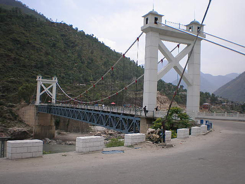
Figure 1.17 Youyi Bridge, Thakot on N 35
Rail and Airways; Battagram district
There is no railway station the district. The nearest railway station is that in Abbottabad.
There is no airport—commercial or military—in the district. The nearest airport is the Abbottabad International Airport.
Radio and Television; Battagram district
Pakistan Broadcasting Corporation (PBC) does not have a radio station (either AM or FM) in the district. There is no privately-owned radio station in the district.
There is no TV station in the district but TV can be viewed through cable.
Telecommunications; Battagram district
According to the KP Development Statistics 2018-19, there are 03 telephone exchanges in Battagram district with 760 connections.
Post Offices/ Courier Services; Battagram district
There are 37 post offices in the district (with no Head Office), 09 Sub-Post Offices and 28 Branch Post Offices in the district (KP Development Statistics 2018-19).
Banking/ Financial Institutions; Battagram district
There are 16 Branches of various banks operating in the district (KP Development Statistics 2018-19). Some of these are:
- Bank of Khyber
- Muslim Commercial Bank
- Bank Islami
- Zarai Taraquiati Bank
- National Bank of Pakistan
- Habib Bank Ltd.
In all there are 12 branches of various conventional banks and 04 branches of different Islamic banks in the District.
Electricity and Gas; Battagram district
Peshawar Electric Supply Company (PESCO) looks after electricity distribution and transmission to all the districts of KP. PESCO networks own and maintain KP’s electricity distribution system via 132, 66, and 33 KV sub-transmission lines and sub-stations, as well as 11 KV and 440 V low tension lines with distribution transformers that deliver electricity to domestic and commercial users.
The Allai Khwar Hydro Power Project, completed in 2012, supplies 121 MW power to the national grid.
[1] Khyber Pakhtunkhwa, Comprehensive Development Strategy 2010-2017 P&D Govt. Of Khyber Pakhtunkhwa
Educational Institutions Battagram district
The following table shows the number of Government Educational Institutions in the district as per KP Development Statistics 2018-19:
| Institution | Boys/Girls | Institution | Boys/Girls |
| Primary Schools | 430/189 | Middle Schools | 26/20 |
| High Schools | 36/08 | Higher Secondary Schools | 03/01 |
| Mosque Schools | 47 | Degree Colleges | 01/01 |
| Polytechnic Institutes | – | Commerce Colleges/Institutes | – |
| Vocational Centers | 01 | Private Primary Schools | 39 |
| Private Schools (Middle + Higher Secondary) | 36 | Universities | – |
| Medical Colleges | – | Engineering Colleges | – |
Table 1.11 Battagram Educational Institutes
Healthcare Facilities; Battagram district
The following table shows the government health care institutions in the district as per KP Development Statistics 2018-19:
| Institution | No./Beds | Institution | No./Beds |
| Hospitals | 02/174 | Dispensaries | 9/- |
| Rural Health Centers | 02/16 | Basic Health Units | 28/- |
| Mother Child Health Centers | 01/- | Sub-Health Centers | – |
| Leprosy Clinic | 02/- | TB Clinics | 01/- |
| Private Hospitals | 05/40 | Private Medical Practitioners | 47 |
Table 1.12 Battagram Health Institutes
Policing; Battagram district
The District Police Officer (DPO) Battagram is in charge of policing Battagram district. The DPO reports to the Deputy Inspector General Police (DIGP) who, in turn, reports to the District Coordination Officer. In Battagram district, there are06 police stations.[1]
[1] Table no. 19.7 (a) Number of Police Stations by Division/District.
Environment and Biodiversity; Battagram District
Since the industrial base of the district is very low, very little air pollution exists and the quality of air is generally good.
Flora and Fauna; Battagram district
Flora; Battagram district
The district is home to a large variety of flora, some of which has been listed in the Forests section. Battagram district/ Allai Tehsil boasts 415 species of vascular flora, of which 246 are herbs, 75 shrubs, 68 species of trees, 06 of climbing shrubs, and 18 of climbers, as well as 03 epiphytes. Of these, 185 plant species are used for medicinal purposes.[1] There are 156 medicinal plants in the Nandyar Catchment Area (Battagram Tehsil), of which 22 are used to cure livestock.[2]
The important medicinal plants common to both Battagram and Allai are palosa (Acacia modesta), sarba zailay or atees (Aconitum heterophyllum), skhawaja or sweet flag (Acorus calamus), yakhbooti (Ajuga bracteosa), Indian belladona (Atropa acuminate), kwaray or sumbul (Berberis lyceum), villanay or jangli podina (Mentha longifolia), narsaw-ay or anar or pomegranate (Punica granatum), bankakri or Himalayan may apple (Podophyllum emodi), mushk e-bala (Valeriana jatamansi), banafsha (Viola canescens), and dambara timber or timmer (Zanthoxylum alatum).
There are 37 timber wood species in the district. The timber yielding plants are used in roofs, doors, windows, and in furniture. Some of them include Himalayan fir (Abies pindrow), Indian horse chestnut (Aesculus indica), date plum (Diospyros lotus), walnut (Juglans regia), Himalayan spruce (Picea smithiana), chir pine (Pinus roxburghii), blue pine (Pinus wallichiana), chinar (Platanus orientalis), Himalayan elm (Ulmus wallichiana), partal (Abies pindrow), bhan tung or smoke tree (Cotinus coggygria), sanatha (Dodonaea viscosa), jungle methi or ghoreja (Indigofera heterantha), kachal (Picea smithiana), and common ditch reed or nal (Phragmites australis).
There are 73 plant species that are considered to be wild ornamental due to their fragrant and colorful flowers including marshmallow or holly hock (Althaea ludwigii), Himalayan columbine or blue-violet columbine (Aquilegia pubiflora), juha or kalulu (Delphinum vestitum), St. John’s wort (Hypericum oblongifolium) Himalayan elecampane, or pauskaramula (Inula royleana), jasmine (Jasminum sp.), nargis (Narcissus tazetta), cotton thistle (Onopordum acanthium), Himalayan musk rose (Rosa moschata), Jeruselum cherry (Solanum pseudocapsicum), Himalayan meadows feet (Spiraea vaccinifolia), and Himalayan white tulip (Tulipa stellate).
Hundreds of plant species are weeds that grow along cereal plants and compete for nutrients, causing less productivity of cereal crops. These weeds include Conyza canadensis, Cynodon dactylon, Ipomoea eriocarpa, Ipomoea turbinata, Ranunculus arvensis, Tagetes minuta, and Xanthium stromarium.
There are 48 plants that bear edible fruits and seeds including various species of berries (Berberis sp.), varieties of persimmon (Diospyros sp.), species of strawberries (Duchesnea indica.), species of figs (Ficus sp.), walnut (Juglans regia), mulberry (Morus sp.), dew berries (Rubus sp.), mako or black night shade (Solanum nigrum.), grapevine (Vitis jacquemontii), and ber (Zizyphus sp.).
There are 43 wild plant species that are used as vegetables and potherbs, including species of onion (Allium filidens), chulai or species of spinach (Amaranthus viridus), shepherd’s purse (Capsella bursa-pastoris), kowanjay (Dryopteris jaxtapostia), water cress or halyun (Lepidium), species of mustard family (apctalum and Lepidium pinnatifidum), species of alfalfa (Medicago denticulate and Medicago lupulina), species of mint (Mentha longifolia and Mentha spicata), purslane or kulfa (Portulaca oleracea), and Himalayan thyme or ajwain (Thymus linearis).
Fauna; Battagram district
The mammals found in the district include common leopard, leopard cat, snow leopard, brown bear, black bear, brown monkey, white monkey, jackals, musk deer, wild goat (ibex), wild boar, jungle cat, Kashmir fox, mongoose, grey goral, hare, porcupine, flying squirrel, and yellow-throated martin.
Avifauna of the district includes chakor, monal pheasant, kalij pheasant, koklas pheasant, shikra, myna, ducks, pigeons, crows, sparrows, partridges, chir pheasant, mountain crows, dove, western tragopan, tawny eagle, greater spotted eagle, merlin, common kestrel, parakeet, crested lark, wagtails, martins, bulbuls, brown dipper, wheat-eater, warblers, rooks, Indian silverbill, black kites, Indian woodpeckers, and Himalayan griffon vulture.
Reptiles found in the district include cobra, rat-eater snakes, phissi snakes, lizards, frogs, monitor lizard, Russel’s viper, and saw-scaled viper.
Protected Wildlife Areas and Endangered Wildlife of Battagram District
There are no protected wildlife areas in the district, but there are a large number of mammals and birds[3] found in the district that are on the critically endangered IUCN list. The flora includes maple (Acer Caesium Wall), birch (Betula utilis D. Don), deodar (Cedrus deodara Roxb. ex Lamb), Indian fig or sweet prickly pear (Opuntia dilleni haw), mamekh (Paeonia emodi wall), kakar singhi (Pistacea integerrima), white poplar (Populus alba), banni or barin oak (Quercus glauca), baru or nur (Skimmia laureola), Himalayan yew (Taxus. wallichiana), Himalayan elm or kain (Ulmus wallichiana), and mistletoe (Viscum album).
Critically endangered fauna includes white and brown monkeys, common leopard, leopard cat, snow leopard, brown bear, black bear, yellow-throated marten, chakor, monal pheasant, kalij pheasant, and koklas pheasant.

Figure 1.5 Misteletoe Growing on a Birch Tree

Figure 1.6 Yellow-throated Marten
[1] Species Diversity of the Vascular Flora in Different Vegetational and Climatic Zones of Allai Valley Western Himalaya, Pakistan by Faizul Haq, Habib Ahmad, Rahatullah, and Zafar Iqbal
[2] Traditional Uses of Medicinal Plants of Nandiar Khuwarr Catchment (District Battagram), Pakistan by Faizul Haq, Habib Ahmad, and Mukhtar Alam
[3] The Critically Endangered Flora and Fauna of District Battagram Pakistan, Faizul Haq