Share now
Map of Khyber Pakhtunkhwa

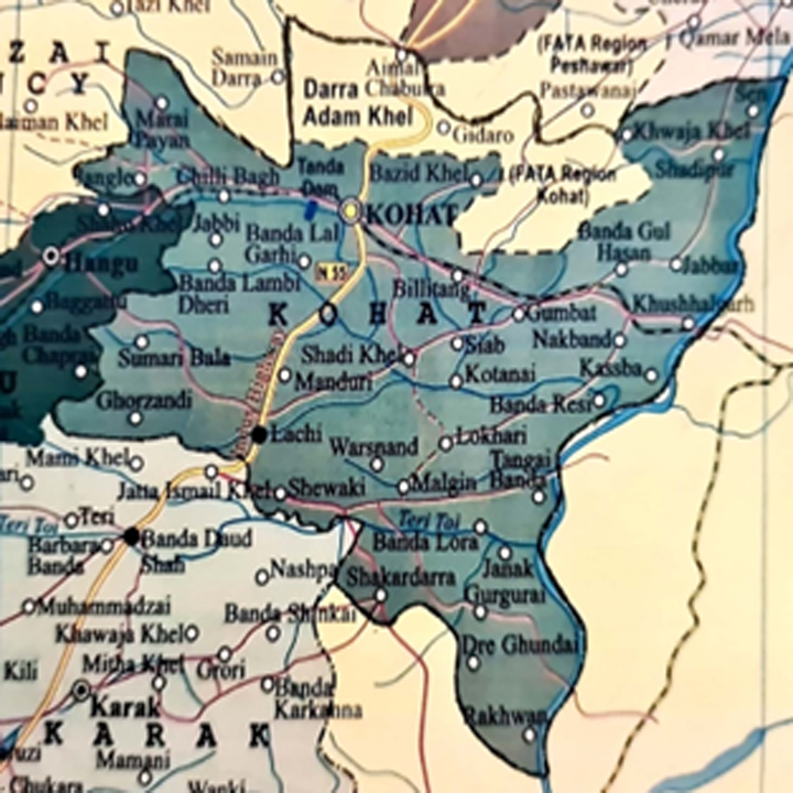
Map of Kohat District Including former FR Kohat
Khyber Pakhtunkhwa Districts
- Peshawar District Profile
- Abbottabad District Profile
- Bannu District Profile
- Battagram District Profile
- Buner District Profile
- Charsadda District Profile
- Chitral District Profile
- Dera Ismail Khan District Profile
- Lower Dir District Profile
- Upper Dir District Profile
- Hangu District Profile
- Haripur District Profile
- Karak District Profile
- Kohat District Profile
- Kohistan District Profile
- Lakki Marwat District Profile
- Malakand District Profile
- Mansehra District Profile
- Mardan District Profile
- Nowshera District Profile
- Shangla District Profile
- Swabi District Profile
- Swat District Profile
- Tank District Profile
- Torghar District Profile
- Bajaur Tribal Distyrict Ptofile
- Khyber Tribal District Profile
- Kurram Tribal District
- Mohmand Tribal District Profile
- North Waziristan Tribal District Profile
- Orakzai Tribal District Profile
- South Waziristan Tribal District Profile
Also visit: Sindh, Punjab, Baluchistan
Introduction/Geographical Details of Kohat District
The Tribal Areas adjoining Kohat district (originally part of FATA) are now part of Kohat district and is located between 33° 04Ꞌ to 33° 46Ꞌ north latitudes, and 70° 29Ꞌ and 72° 01Ꞌ east longitudes. It is bounded on the north by Orakzai district (originally Orakzai Agency part of FATA), Peshawar and Nowshera districts; on the east by Attock district (Punjab); on the south by Mianwali district (Punjab) and Karak district; and on the west by Hangu district and Orakzai district. The name Kohat is composed of two words: “Koh” meaning mountain and “Hat” meaning a market, and hence the name Kohat means mountain market.
Kohat District at a Glance
| Name of District | Kohat District | ||
| Headquarters | Kohat City | ||
| Population[1] | 1,112,452 persons | ||
| Area[2] | 2,991 sq. km. | ||
| Population Density[3] | 371.9 persons per sq. km | ||
| Growth Rate[4] | 2.3% | ||
| Male Population[5] | 50.0% | ||
| Female Population[6] | 50.0% | ||
| Urban Population[7] | 24.3% | ||
| Literacy Rate[8] | 46.8% | ||
| Male Literacy Rate[9] | 65.5% | ||
| Female Literacy Rate[10] | 28.6% | ||
| Administrative Units |
02 Tehsils: 1. Kohat Tehsil 2. Lachhi Tehsil 3. Kohat Sub-Division (former FR Kohat) |
||
| Important Cities | Kohat, Muslimabad, Lachhi, Shakardara, Khushal Garh, Darra Adam Khel, Darsamand, Billitang Village Gandyale Bala, Togh Bala, Kharmato, Banda Jalal Abad, Bahadar Kot, Usterzai Payan, Usterzai Bala, Sherkot, Ali Zai/Khade Zai, Kachai, Nusrat Khel, Gumbat, Barh, Togh, and Jabbi, Darra Adam Khel, Jawaki Adam Khel. | ||
| Major Economic Activity[11] | Community, Social & Personal Services | 33.6% | |
| Agriculture with its Allied Livestock Breeding & Fishing | 26.6% | ||
| Wholesale/Retail, Hotel/ Restaurant | 13.5% | ||
| Construction | 9.7% | ||
| Transport, Storage And Communication | 8.5% | ||
| Others | 8% | ||
| Main Crops | Wheat, barley, maize, bajra, ground nuts, sugarcane, rice, jowar, gram, rapeseed, mustard, moong, and sesanum | ||
| Major Fruits | Citrus, guava, apricot, plums, mulberry, ber, loquat, peaches, persimmon, and gurgura (a kind of berry) | ||
| Major Vegetables | Onion, garlic, okra, brinjal, turnip, carrots, tomatoes, chilies, spinach, radish, cabbage, tinda, bottle gourd and coriander | ||
| Forest (Area)[12] | 28,592 HA[13] | ||
| Black Topped Roads[14] | 489.0 km | ||
| Shingle Roads[15] | 165.5 km | ||
| Electricity | Peshawar Electric Supply Corporation (PESCO) looks after distribution and transmission of electricity in the district | ||
| Telephone Exchanges[16] | There are 13 telephone exchanges with 5,806 connections | ||
| Industrial Zones[17] | There is 1 Small Industries Estate in Kohat and 19 industrial units in the district. In the Kohat Sub-Division (former FR Kohat) there were 532 Industrial units according to the 2013-14 statistics (Latest available) | ||
| Major Industry[18] | Flour Mills | 9 Units | |
| Carpet & Cement | 1 Unit Ea. | ||
| Cement Based | 2 Units | ||
| Ice Factories | 3 Units | ||
| Textile Mills | 3 Units | ||
| Arms and Armaments | 558 Units[19] | ||
| Household Size[20] | 7.5 persons per house | ||
| Houses with Piped Water[21] | 57.6% | ||
| Houses with Electricity[22] | 86.2% | ||
Table 1.1 Kohat District at a Glance
[1] 2017 Population Census; includes population of Ex FR Kohat also.
[2] 1998 Census; includes area for Ex. FR Kohat also
[3] 2017 Census
[4] 2017 Census (taken as average of growth rate for Kohat district and FR Kohat)
[5] 2017 Census (includes of FR Kohat also)
[6] 2017 Census (———–do——————)
[7] 2017 Census (accounts for FR Kohat also)
[8] Pakistan Social & Living Measurement Survey 2014-15 (PSLM) and FATA Education Atlas 2011-12 Latest available; average of lierracy rate of Kohat District and Ex. FR Kohat).
[9] PSLM (Same as above)
[10] PSLM (Same as above)
[11] 1998 Census; 2017 Census results have not been made public; Data for FR Kohat region is also not available.
[12] KP Development Statistics, 2018-19.
[13] Land Utilization Statistics Report 5,076 HA under Forests (this includes area of FR Kohat also)..
[14] KP Development Statistics, 2018-19
[15] KP Development Statistics, 2018-19
[16] KP Development Statistics, 2018-19
[17] KP Development Statistics, 2018-19
[18] KP Development Statistics, 2018-19
[19] Please see the article on Industry for detailed list of Industries in the Kohat Sub-Division
[20] 1998 Census; 2017 Census data has not been released yet.
[21] 1998 Census; 2017 Census data has not been released yet.
[22] 1998 Census; 2017 Census data has not been released yet.
Brief History – Governmental Structure – Administrative Divisions – Heritage Sites/ Tourist Attractions
Brief History of Kohat District
Most of the ancient history of the areas comprising Kohat district is obscure. According to popular local belief, during the Buddhist era, two brothers named Kohat and Adh settled along the northern borders of the district. Kohat founded the Kohat Town and Adh settled on a hill north of the Muhammadzai, a village 4 miles (6.5 km) to the west of Kohat, where he built a fort (the ruins of this fort are still present). This settlement is known as Adh-i-Samut. The ruins of the fort consist of old ramparts which are still extant. This fort was constructed far below the crest of the mountains of Kohat.
The only other physical remnants of the Buddhist era is a road cut out of a mountain, near the village Kotal on the western skirts of the Jawaki hills, which leads to the crest of the mountain.
The first recorded historical mention of Kohat is found in the memoirs of Mughal Emperor Babar. In his memoir Tuzk-e-Babri [the book of Babar], he recounts a visit to Kohat in 1505 AD during his first Indian expedition, and calls the inhabitants of the areas Afghans. After Babar’s account, the historical records recount the settlement of the areas by two major tribes namely Bangash and Khattak. These tribes appear[1] to have settled in the district during the 14th and 15th centuries.
The Kohat areas remained a part of the Mughal Empire, but the Emperors maintained only a nominal hold over the tract. During Akbar the Great’s rule, one of the Khattak Chiefs, Malik Akor, was made the Governor of the area. He founded the town Akora Khattak (now in Nowshera district) and made it the seat of his governorship. He handed down his authority to his descendants who ruled from Akora. He was the grandfather of the famous warrior poet Khushal Khan Khattak.
The Imperial Gazetteer of India states:
The district was then as now divided between the Bangash and Khattak Tribes[2]. The Bangash occupying the Miranzai Valley with the western portion of Kohat proper, and the Khattaks held the rest of the eastern areas upto the banks of River Indus. (v. 15, p. 342)
From the time[3] of the Emperor Akbar to the invasion of Nadir Shah, Kohat district formed part of the Mughal Empire. During the declining years of the Mughal Empire (1707-1857) the Afghans, Marathas, and Sikhs started gaining strength, and by 1748 the Mughal Empire practically broke up with Oudh (now Ayodhya), Rohilkhand (southeast of Delhi), Bengal, Gujrat, and Malwa among others becoming more independent.[4] In 1738 Nadir Shah of Iran, taking advantage of the weak Mughal Emperor (Nasir-ud din Muhammad Shah), attacked India, and after sacking Delhi, took control of all of the Trans Indus tracts.
Kohat, however, escaped the attacks of Nadir Shah, since a part of his forces went through Peshawar and the other part through Kurram and Bannu. After Nadir Shah’s death in 1747, the areas controlled by Nadir Shah passed to the Durrani Empire under Ahmad Shah Durrani. In March 1748, while retaining control of Kohat, Ahmad Shah Abdali/Durrani again invaded the Mughal Empire but the forces of Muḥammad Shah under the leadership of his heir and Grand Wazir, defeated the invaders at Manipur.
Kohat remained part of the Durrani Empire from 1747, but the authority of the Durranis was exercised through the Bangash and Khattak chiefs. After the fall of the Afghan King Shah Shuja Durrani in 1810, Kohat came directly under the control of the rulers of Kabul and Peshawar. Kohat was first leased to Munshi Bashi for a sum of Rs 33,000. He was succeeded by Sardar Shakur Khan, who, in turn, had to evacuate in favour of Shahzada Muhammad Sultan, brother of King Mahmud Shah Durrani. The whole country (Kohat areas included) revolted against the Abdali/Durrani dynasty in 1818, and the area was parcelled among Fateh Khan’s brothers after Mahmud Shah Durrani murdered Fateh Khan, who was the wazir [high counsellor] and elder brother of Dost Muhammad Khan.[5] Samad Khan was given the areas of Kohat and Hangu.
The sons of Samad Khan were driven out in 1828 by the Peshawar Sardars; the principal of these sons was Sultan Muhammad Khan.[6] Peshawar was conquered by the Sikhs after the Battle of Nowshera in 1823, but the Sikhs found that they could not control the mountain tribes and thus, Ranjit Singh gave Sultan Muhammad Khan the areas of Kohat, Hangu, and Teri as his jagir, and also gave him a position of importance at Peshawar. The Sikhs then abandoned Kohat, and their garrisons at both Teri and Hangu were massacred by the Khattak Chief, Rasul Khan. Rasul Khan became an independent ruler of the Teri Areas in 1843; Teri, thus, became a Princely State. Sultan Muhammad Khan continued to rule Kohat and Hangu with the help of his sons.
On the outbreak of the Second Anglo-Sikh War (1878-1880) George Lawrence, the British Lieutenant General, took refuge at Kohat, but Sultan Muhammad Khan handed him over to the Sikhs as a prisoner. At the close of the war, Sultan Muhammad Khan and his followers retired to Kabul, and Kohat, with the rest of Punjab, was annexed by the British.
Khwaja Muhammad Khan, a descendant of Malik Akor, the Akora Chief and posthumously-born son of Khushal Khan Khattak, was loyal to the British, and was made a Nawab of the area, with the district being given to him as a jagir. In 1872, he was given the title of Nawab, and made a Knight Commander Star of India (KCSI). He died in 1889 and was succeeded by his son Khan Bahadur Abdul Ghafur Khan.
After the annexation of Punjab in 1849, an Assistant Commissioner was assigned to Kohat who looked after the administration of the area, and British interests.
In 1920, the Afridis of the Kohat Pass area, under the leadership of Ajab Khan, raided the armoury of the Cavalry Lines at Kohat and stole 100 rifles. The British launched a search in the Afridi village; they searched the women of the village as well, which was considered a major insult by the tribesmen. Ajab Khan vowed vengeance by kidnapping a British woman. In 1923 with a few of his followers, he invaded the Bungalow of British Major and Mrs. Ellis; Major Ellis, however, was not home, and in the ensuing struggle, Mrs. Ellis was killed, and their 17 year old daughter, Molly Ellis, was kidnapped. The Afridis retreated to Tirah, taking Molly with them. Molly was later recovered by the British, and they found that she had been treated well. Ajab Khan and his gang, however, fled to Afghanistan.
At the time of Partition, Kohat district comprised of 3 Tehsils: Kohat, Teri (Princely State was made a Tehsil of Kohat district in 1940), and Hangu. Hangu was separated from Kohat district and made a district in 1996. Teri was made part of Karak, and upgraded to a district in 1982. At present, Kohat district consists of 2 Tehsils: Kohat and Lachhi Tehsils.
History of Former (Ex.) FR Kohat (now Kohat Sub-Division)
The main clans inhabiting the Ex. F R Kohat are Galai Khel and Jawaki, who branch from the Adam Khel tribe. Other smaller tribes include Tor Sapar, Zarghun Khel, Sheraki and Bosti Khel (clans of Galai Khel), Haibat Khel, Kimat Khel, Bazid Khel and Ashu Khel (clans of Jawaki tribe).
The Adam Khel Afridis occupy the area between Kohat and Peshawar, from Akor, west of the Kohat Pass, to the Khattak boundary.
The Afridi were mostly a nomadic tribe, and almost exclusively inhabited Khyber Agency, as well as Darra Adam Khel (F R Kohat) and Tirah Valley (which occupies the Kurram, Khyber, and Orakzai Agencies). In the summer they migrated to the Tirah heights and their winter quarters were in the Khyber, Bazar, and Kajuri valleys. The Adam Khel clan of Afridi tribe live in F R Kohat and F R Peshawar, and unlike other Afridi clans, they were not nomadic but were more pastoral and settled. The Adam Khels are the custodians of the Kohat Pass and are known for gun manufacturing as well as smuggling in the entire Region.
The British colonizers first came into contact with the Adam Khel Afridis after the annexation of Punjab in 1849. The Adam Khel clan derived much income and prestige from their control of the Kohat Pass and their control over the Kohat salt mines. The British imposed a duty payable on salt produced under what the British regarded as their jurisdiction. This was resented by the tribe and when the British announced construction of a road through Kohat Pass that would pass through land the tribe regarded as their own; conflict ensued. In 1850 the tribe attacked a contingent of Sappers/ British soldiers and after killing 7 Sappers the clan plundered the camp. The British then sent an expedition against the tribe under Colin Campbell and Sir Charles Napier. The tribesmen offered stiff resistance but lost. They re-directed and attacked Kohat. This attack was repulsed by British forces. Next the tribe attacked a police tower which had been constructed by the British on the road to Kohat, taking control of the road. Ultimately, the British passed a law proclaiming that any tribesman seen in the Pass would be killed on sight, effectively quelling the insurgence.[7]
The British undertook other expeditions to subdue various Afridi tribes: against Jowaki Afridi tribe in 1853, against Aka Khel Afridis in 1855, then again against the Jowaki Afridi tribe in 1877, against Zaka Khel Afridis in 1878 and 1879. The last skirmish with the Afridis was in 1923 when Ajab Khan of the Bosti Khel Afridi tribe abducted Miss Molly Elis.
During the British Raj, a Political Tehsildar looked after the affairs of the Tribal Areas of Kohat. The entire Adam Khel clan was formally under the political control of the Deputy Commissioner Kohat, but in 1896 and 1897 the control of the Jawaki Khel sub-clan, was transferred to the Deputy Commissioner Peshawar. The Region was governed under a special law called Frontier Constabulary Law (FC Law), based on local customs and conventions.
At the time of Partition in 1947, these tribes opted for, and became part of, Pakistan. The Region has international fame for its armament industry.
F R Kohat was given the status of a separate Federal Region in the year 1981. Prior to this a Political Tehsildar used to look after its affairs. In 2018 FR Kohat was merged with Kohat district and became Kohat Sub-Division
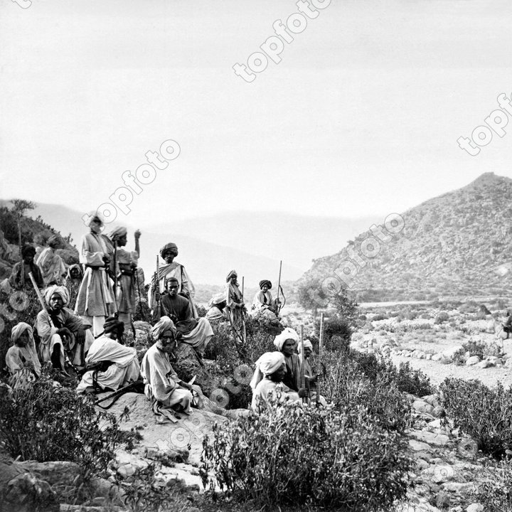
Figure 1.3 Afridis in Kohat Pass, around 1878-1880 by John Burke
Governmental Structure; Kohat district
At the Federal level, Kohat district is allocated a set number of representatives in both the National Assembly and the Provincial Assembly:
- Number of seats in the National Assembly 1
- Number of seats in the Provincial Assembly 5
Under the Local Government Act District Kohat has one District Council constituted by general seats, seats reserved for women, peasants/workers, youth, and non-Muslims as prescribed under the Khyber Pakhtunkhwa Local Government Act 2013. Kohat District Council is composed of 32 general members, 11 women members, 2 peasants/worker members, 2 minority members, and 2 youth members.
The Sub-Division Kohat is represented by the Elected Representatives of former FATA in both National assembly and Provincial Assembly
The former FR Kohat has been divided into 16 councils including 13 village and three neighbourhood councils
Administrative Divisions; Kohat district
Total area of the district is 2,545 km2 (1998 Census) and this is divided into 2 Tehsils as follows:
| Kohat Tehsil | 24 Union Councils |
| Lachhi Tehsil | 03 Union Councils |
| Kohat Sub-Division | 16 Union Councils |
Table 1.2 Kohat Administrative Divisions
[1] District Profile Kohat 1998 by Government of Pakistan.
[2] The time period referred here is from the visit of Babur to British occupation
[3] The following historical account of Kohat has been paraphrased from Imperial Gazetteer of India (v. 15, p.342-343) and A Concise History of Afghanistan in 25 Volumes, (v. 1, p. 338-340).
[4] Encyclopedia Britannica
[5] Dost Muhammad Khan was the King/Amir of Afghanistan from 1826-1839 and then again from 1843-1863
[6] Imperial Gazetteer of North West Frontier Province 1908, p. 170; Sultan Muhammad Khan was the younger brother of Dost Muhammad Khan.
[7] The Forcing of the Kohat Pass, North-West Frontier, by Ensign William Henry Sitwell, 30th Native Infantry
St. John the Baptist, Lowick, Northumberland, 1850
Historic/Heritage Sites; Tourist Attractions; Kohat District
The only historic/heritage site protected under the Government of Pakistan Laws is the Kohat Fort, which was constructed by the British government for military use since Kohat was strategically located, and military operations were conducted against surrounding tribal areas like Dara Adam Khel and Orakzai from this fort.
Other important sites are:
- Shrine of Zinda Peer (Khwaja Zindapeer) also known as Ghamkol Pir, Kohat. He was the founder of Ghamkol Sharif
- Shrine of Haji Bahadar Ali Abdullah Shah alias Haji Bahadar Sahib; Kohat district
- Shrine of Saint Bona Baba, Janan Baba; Kohat district
- Shrine of Hazrat Banoor Baba; Kohat district
- Kohat Springs, believed to be visited by Baba Guru Nanak; Kohat district
- Cavagnari House, constructed in 1862, for the first British Commissioner in-charge of Kohat, Captain Sir Louis Cavagnari, (1866-1877) in Kohat Cantt. It has now been converted into a library; Kohat district
- Palaces of Emperor Durrani and his Princes; Kohat district
- Doda Ground, where Emperor Babar camped on his way to India; Kohat district
- 8 extant gates, out of 12 gates of the walled city; kohat district
- Khushal Garh Bridge; Kohat district
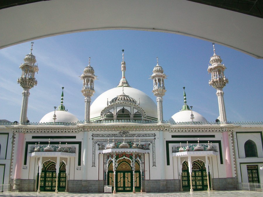
Figure 1.7 Mosque in Ghamkol Sharif
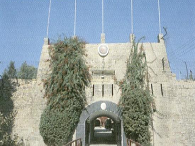
Figure 1.8 Kohat Fort
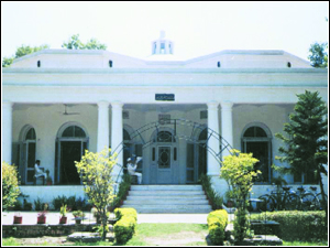
Figure 1.9 Cavagnari House (Now a Library)
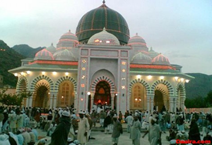
Figure 1.10 Shrine of Zinda Peer
Other places worth visiting in the district are:
- Kohat Town: known for the fort built by the British, which is being used by the Pakistan Army
- Khushal Garh; kohat distrioct: another scenic town of the district. It is located atop a cliff from where River Indus can be viewed
- Tanda Dam; Kohat district: built in the 1960s, the dam is a very popular picnic spot not only for local residents but visitors from across the country and abroad
- Darra: famous for production of arms and the technical skills of the gunsmiths of the area; kohat district
- Shakardara; Kohat district: famous for bee keeping and honey production
In addition to the above, Kohat town is surrounded by mountains, which offer trekking and hiking areas. There are 5 natural springs in the district known as Panjpeer, which are believed to be the meditation grounds of Baba Guru Nanak.

Figure 1.11 Tanda Dam Lake
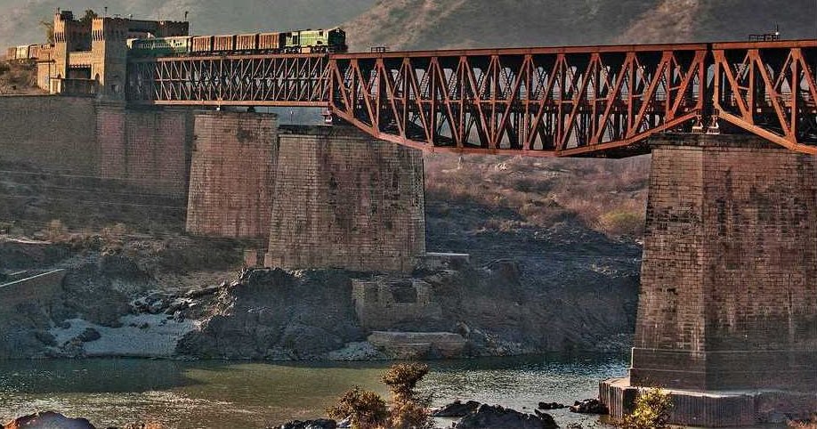
Figure 1.12 Khushalgarh Bridge on River Indus
Parks and gardens of Kohat city include Chali Bagh, Jauzara, Kachai (Katsi) Garden, Tanda Dam Wildlife Park, Caravan Park, Golf Course Park, Kohat Pass Garden and Cantonment Amusement Park.
Following sites of now Kohat Sub-Division can be developed as potential sites for tourism:
- Darra Adam Khel; Kohat district: The town is famous globally for handmade sporting weapons and replicas. The town has a long tradition of making weapons in the small workshops in their homes. The craftsmanship of the locals often surprises visitors who are usually interested in seeing the manufacturing processes and buying weapons and replicas. There are about 50 shops for selling these weapons to visitors
- Kohat Pass; Kohat district, which connects the Adam Khel Territory with Peshawar and Kohat
Topography of Kohat District
The general altitude of Kohat city is 518 m above mean sea level. The general slope is to the east, but on the southwest the fall/slope is towards west, into the Kurram River.
The district consists of a succession of hill ranges, broken into spurs, ravines, and valleys which are, at places, cultivated but more often bare and sandy. The general trend of these hills is east and west, and between these hills are located open valleys. These ranges are of no great height, though several peaks attain altitudes of about 1,433 m or 1,494 meters.
Important mountains[1] in Kohat are the Cherat, Nilab, Khigana, Swanai Sar, Miranzai, and Lawaghar Ranges.
- The Cherat Hills form the boundary between Nowshera district and Kohat. The highest peak is called Jalala Sar (1,524 meters)
- The Nilab Hill Range cuts across River Indus (on reaching Nilab hills, the Indus turns due west till it finds a gap in the range, and the river turns south), into Rawalpindi
- Khigana Hill Range separates the district from Federal Region (FR) Kohat in FATA. The Kohat Tunnel passes through these mountains. The National Highway N-55 or the Indus Highway goes through this tunnel
- Swanai Sar Hill Range separates the district from Karak district. This hill is 1,459 m high
- Lower Miranzai Hill Range separates the district from Hangu. This hill range and the valley is occupied by the Bangash tribe
- Lawaghar Hill Range separates the district from Isa Khel (now in Mianwali district, Punjab). This Range and valley is occupied by the Khattak tribe
Other mountain ranges of the district include Kamar-Tanda in the south of the district. The height of this range varies from 650 to 1,000 m. In the northeast, the Sowaki and Adan Khel Hills run in a southwest-northeast direction. These hills gradually rise in the extreme northeastern part of the district.
The intervening open valleys between the hills are seldom more than 8 km in width.
Topography of former FR Kohat (now Kohat Sub Division)
The area[2] is comprised of a variety of landforms. The western part is higher and more complex where average height of the hills is around 1,500 m. The highest point of the area is located near the western border with a height of 1,198 m. In the eastern half, the height of the hills decreases. The hills flanking the narrow plain area are about 600 m high. The most notable peaks are Ziauddin, Mahr Ali Sar (west of Darra Adam Khel), Sargasha ridge (north of Darra Adam Khel) and Tambal Peak (south of Darra Adam Khel). Kikar and gurgura grow on these hills.
The land as a whole is barani (dependent on rains for agriculture), except the Tor Sapar area, which is irrigated by wells, and a few areas in Sani Khel and Akhor limits, which are watered from springs and wells respectively.[3]
Figure 1.5 Jammu Jawaki Terrain FR Kohat
Soils of Kohat district
Soils of Kohat district varied from clay to sandy loam;
Rivers, Streams, and Lakes; Kohat district
The River Indus forms the eastern boundary of the district, and separates it from the province of Punjab. Kohat Toi is the principal stream, which enters from Hangu district and drains into River Indus, flowing east and southeast. The Kohat Toi has several small torrents or tributaries that join it at different places. Another stream, the Teri Toi, flowing from west to east in the southern half of the district joins the River Indus.
Some of the smaller streams/rivers flowing through the district and joining River Indus are Naru Algad (tributary of Teri Toi), Tarkha Algad, Lachhi Toi, Kakh Algad, Lagorai Algad, Narai Algad, Lilian Algad, Tit Kamar Algad, Sumari Toi, and Shisham Algad.
Tanda Lake is an important lake in the district, and was formed due to the construction of Tanda Dam.
There is no perennial stream or river in the Kohat Sub Division; water flows in khwars (torrents), which depend almost exclusively on rainfall. Some of these hill torrents flowing intermittently through F R Kohat include Janakor Khwar, Gar Algad, Musadarra Khwar, Namalkas, Khangai Khwar, and Palosi Khwar.
Forests of Kohat district
Nearly 2.5% of the land area is under forests in Kohat district. The main forest types of the district are Sub-Tropical Dry Forests. Dominant tree species are phulai (Acacia modesta), kau (Olea cuspidata) and hopbush (Dodonaea viscosa), ber (Zizyphus jujuba), black and white mulberry (Morus alba), shisham (Dalbergia sissoo), poplar/ sufaida (Populous sp.), maple/ chinar (Acer sp.), and varieties of acacia like phulai, and kikar. Bakain (Melia azarderach), sanatha (Dodonaea viscosa) and eucalyptus.
The following table shows the status of forests in the district as per KP Development Statistics 2018-19:
| Total Forest Area | 70,654 A | Resumed Land | 10,134 A |
| Reserved Forests | 5,000 A | Communal Forests | – A |
| Protected Forests | – A | Guzara Forests | – A |
| Unclassed Forests[4] | – A | Private Plantation | 44,189 A |
| Section 38 Forests[5] | 11,131 A | Miscellaneous | 200 A |
| Linear Plantation | 15 km |
Table 1.3 Kohat Forests
Tanda Wildlife Park and Kohat Wildlife Park are protected reserved forests of the district. Government-owned and protected game reserves of the district include Balyamin, Shawaki, Chukhtoo, Rakh Topi, Resi, Toi Banda, Kachai Marai, Gurzandi, Jabbar, Marchungee, Darmalak, and Dhoda. Community-owned and protected game reserves include Dhok Dheri, Dhok Lohran, Darbokach, Usterzai Payan, Kanra Cheena, Shamshattu, Soor Dag, Jatta Ismail Khan, Lak-Kana, Daresh Khel, Dowro/Algada, Darwazai Banda, Sumari Bala, Shazadi Banda, Kamar, and Dhandidal Khel.
Climate of Kohat district
The climate of the district is hot from May to September. June is the hottest month. The mean maximum and minimum temperatures recorded during June are about 40 °C and 27 °C respectively. A pleasant change in the weather is noted from October to February. The winter is cold and severe. In winter, a strong west wind known as the Hangu Breeze often blows down the Miranzai Valley towards Kohat. The mean maximum and minimum temperatures recorded during the month of January, are about 18 °C and 6 °C respectively.
The monsoon rain is received from May to October. August is the wettest month, with an average rainfall of about 111 mm. The winter rain occurs from November to April. The highest winter rainfall is received in the month of March. The average annual rainfall is highest winter rainfall is received in the month of March. The average annual rainfall is about 546 mm. The maximum humidity has been recorded in the month of August during the summer season, and in December during the winter season.
Seismic Activity/Seismicity; Kohat district
The district belongs to Zone 2B of the Seismic Zone Map of Pakistan, which means minor to moderate damage due to earthquakes.
[1] Report on the Land Settlement of the Kohat District in the Punjab 1884
[2] Profile of Tribal Areas Adjoining Kohat District 1998, Government of Pakistan.
[3] Official Website FATA: FR Kohat. retrieved 2013
[4] Owned by Government
[5] Land given up voluntarily
Population of Kohat District
The following table shows the population of Kohat district including Kohat Sub-Division as per the 2017 Census:
| District |
Area km2 |
Population | Male% | Female% | Urban % | Growth Rate % |
| Kohat District | 2,991 | 1,111,266 | 50.0 | 50.0 | 24.3 | 2.3 |
| Kohat Tehsil | 850,336 | |||||
| Lachhi Tehsil | 143,542 | |||||
| Kohat Sub Division | 446 | 118,839 | – |
Table 1.4 Kohat Population Statistics
Religions; Kohat district[1]
| Muslims | 99.1% |
| Christians | 0.5% |
| Hindus | 0.1% |
| Ahmadis | 0.3% |
| Scheduled Castes | Negligible % |
| Others | Negligible % |
Table 1.5 Kohat Religions
Languages; Kohat district[2]
| Urdu | 0.8% |
| Punjabi | 3.4% |
| Sindhi | 0.1% |
| Pushto | 77.5% |
| Balochi | Negligible % |
| Seraiki | 0.9% |
| Others[3] | 17.3% |
Table 1.6 Kohat Languages
[1] 1998 Census; 2017 Census data has not been made public yet
[2] 1998 Census; 2017 Census data has not been made public yet
[3] languages include Kohati/Hindko, a dialect of Punjabi language
Economic Activity – Economic Infrastructure
Economic Activity; Kohat District
According to the 1998[1] Census, the industrial occupations of the district are:
- Community, Social and personal services (33.6%)
- Agriculture with its Allied Livestock Breeding & Fishing (26.6%)
- Wholesale/Retail & Hotel/Restaurant (13.5%)
- Construction (9.7%)
- Transport, Storage & Communication (8.5%)
- Others (8%)
[1] 2017 Census results have not been made public yet.
Land Use; Kohat district
The following table gives the major land use statistics of Kohat district (KP Development Statistics 2018-19):
| Total Area | 299,100 HA | Reported Area | 339,731 HA |
| Cultivated Area | 77,209 HA | Net Sown Area | 34,148 HA |
| Current Fallows | 43,061 HA | Uncultivated Area | 262,522 HA |
| Forest Area | 4,821 HA |
Table 1.7 Kohat Land Use Statistics
Agriculture; Kohat district
The district belongs to the Western Dry Mountain Agro-Ecological Zone of Pakistan and agriculture is mostly subsistence level and rain fed. The main crops of the district include wheat, barley, maize, bajra, ground nuts, sugarcane, rice, jowar, gram, rapeseed and mustard, moong, and sesanum.
Due to scarcity of water, horticulture is not practised on a very large scale in the district, but some fruit orchards are grown. The fruit orchards consist of citrus, guava, apricot, plums, mulberry, ber, loquat, persimmon, and gurgura (a kind of berry). The main vegetable produce of the district includes onion, garlic, okra, brinjal, turnip, carrots, tomatoes, chilies, spinach, radishes, cabbage, and coriander.
Irrigation Network; Kohat district
Generally, the area belongs to the Western Dry Mountain Agro-Ecological Zone of Pakistan and agriculture is mostly rain fed. The main source of irrigation is the Tanda Dam Canal Irrigation System. There are other smaller dams which also provide irrigation water; these are Kander Dam (Kohat), Darwezai (Kohat), Chanda Fateh Khan (Lachhi), and Gandiali Dam (Gandiali Bala town of the district). All these dams store rain water which is later used for irrigation purposes.
The following table shows the area and mode of irrigation in Kohat district (KP Development Statistics 2018-19):
| Total Irrigated Area | 16,446 HA | Government Canals | 5,753 HA |
| Private Canals | 15 HA | Tube Wells | 2,902 HA |
| Wells | 1,913 HA | Others | 5,643 HA |
| Lift Pumps | 220 HA |
Table 1.11 Kohat Irrigation Statistics
Livestock Breeding; Kohat district
The following table shows the statistics of livestock for the district as per Livestock Census 2006 (qtd. in KP Development Statistics 2018-19)[1]; Livestock data for former FR Kohat has been added:
| Cattle | 190,666 Heads | Buffaloes | 27,538 Heads | Sheep | 116,010 Heads |
| Goats | 345,811 Heads | Camels | 2,298 Heads | Horses | 407 Heads |
| Mules | 383 Heads | Asses | 23,065 Heads |
Table 1.8 Kohat Livestock Statistics
Rojhan and danni cattle, as well as hashtnagri and balkhi sheep are native breeds of the district.
Poultry Farms; Kohat district
According to Table 17 (Number of Commercial Poultry Farms and Number of Birds by Size of Flock) there are 81 poultry farms in the district.
Fishing; Kohat district
Fishing is one of the important economic activities in the district. Fishing is carried out in the different rivers/streams and lakes formed by the small dams. Most of the fish is exported to other parts of Pakistan.
Bee Keeping/Apiary; Kohat district
In Kohat district, Shakadara is famous for bee keeping and honey processing. About 150 bee keeping farms[2] are currently active in Kohat district, making it a good source of income for the inhabitants of this area. The Government of Pakistan is promoting beekeeping and the honey production industry in the Kohat Sub Division to help create employment and for income generation purposes.
Minerals and Mining; Kohat district
The minerals that are being mined on a commercial basis in the district include coal, gypsum, limestone, shale clay, and silica sand. Oil and Gas is being mined in Kohat district.
Industry and Manufacturing; Kohat distrivt
There is 1 Small Industries Estate in Kohat, and a total of 19 industrial units. The following table shows the type of industry and its number according to KP Development Statistics 2018-19:
| Industry | Number | Industry | Number |
| Carpet | 01 | Cement | 01 |
| Cement Based | 02 | Flour Mills | 09 |
| Ice Factories | 03 | Textile Mills | 03 |
Table 1.9 Kohat Industries
Following table shows the type and number of industries in the former FR Kohat (as per FATA Development Statistics 2013-14 (Latest available)
| Type Of Industry | Number | Type Of Industry | Number |
| Arms and Ammunition | 558 Units | Juices | 02 Units |
| Stone Crushing | 03 Units | Industrial Dyes | 01 Unit |
| Marble Tiles | 01 Unit | Pipes | 04 Units |
| Plastic Goods | 02 Units | Pumps | 18 Units |
| Soaps | 01 Unit | Spare Parts | 06 Units |
| Springs | 01 Unit | Tissue Paper | 01 Unit |
| UPS | 01 Unit |
Table 1.8 F R Kohat Industries
Handicrafts; Kohat district
The main handicrafts of the district include embroidered chappals (sandals) popularly called Kohati Chappals, khaddar cloth (handwoven cloth), woven baskets, wall hangings, and jewellery boxes from mazri palm leaves, as well as leather products like purses, wallets, belts, guns, and other arms and armaments. The former FR Kohat (now Kohat Sub-Division is famous world wide for its handmade arms and armaments
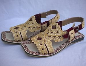
Figure 1.6 Kohati Chappals
[1] Added livestock of Ex FR Kohat from FATA Development Statistics 2013-14
[2] District Profile, Kohat District. Small Medium Enterprise Development Authority (SMEDA)
Economic Infrastructure; Kohat District
One of the main highways of Pakistan, the Indus Highway designated as National Highway N-55, passes through the district, and is connected to Peshawar via the Kohat tunnel, which is a 1.9 km long tunnel constructed with Japanese assistance and called the Friendship Tunnel.
Road Statistics; Kohat district
KP Development Statistics 2018-19 provides the road statistics of the district as:
| High Type | 489.7 km |
| Low Type | 165.5 km |
| Total | 655.2 km |
Table 1.10 Kohat Road Statistics
Important roads of Kohat district include:
- Kohat-Khushal Garh Road
- Kohat-Hangu Road
- Kohat-Doda Guddi Road
- Jata-Shakardara Road
- Indus Highway (National Highway N-55) passes through the district
- Rawalpindi-Kohat Road
- Kohat-bannu Road
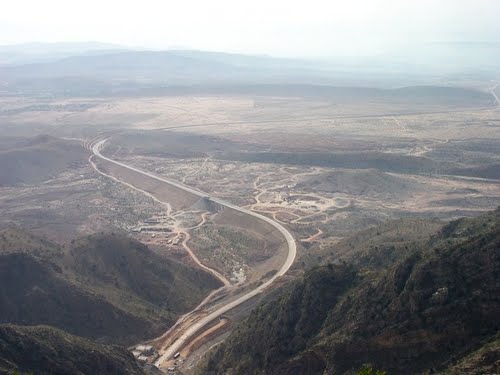
Figure 1.13 Indus Highway Leading to Kohat Tunnel
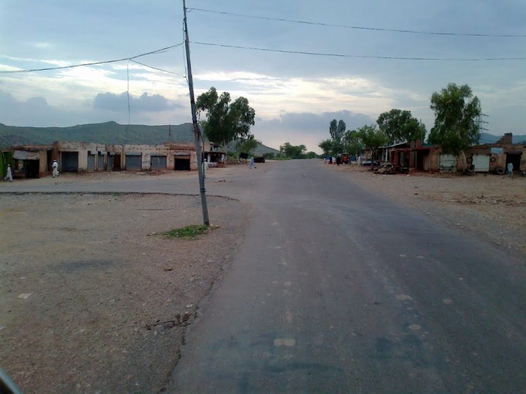
Figure 1.14 Kohat Bypass
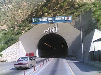
Figure 1.15 Kohat Tunnel
Figure 1.16 Peshawar-Kohat Road through Darra Adam Khel
The Khushal Garh Bridge over River Indus was constructed in 1905, by the British. It was a double-decked bridge, with the upper deck for road traffic. Once this bridge outlived its life, another bridge was constructed close to it, and is now used for traffic.
Rail and Airways; Kohat district
There is a narrow gauge railway line in the district, which connects it to the other parts of Pakistan. The town of Kohat is also connected to Rawalpindi and other parts of Pakistan through railway lines.
There is a commercially operated domestic airport in Kohat, and a military air base operated by Pakistan Air Force in the district.
Radio Television; Kohat district
Pakistan Broadcasting Corporation (PBC) has one FM radio station in the district. There are 2 privately-owned FM radio stations in the district as well.
Even though there is no TV station, TV can be viewed through cable.
Telecommunications; Kohat district
According to KP Development Statistics 2018-19, there are 21 telephone exchanges, with 7,353 connections in Kohat district.
Post Offices/ Courier Services; Kohat district
There are 80 post offices in the district with 1 Head Office, 31 Sub-Post Offices, and 48 Branch Post Offices in the district (KP Development Statistics 2018-19).
Banking/ Financial Institutions; Kohat district
There are a total of 30 bank branches operating in the district (KP Development Statistics 2018-19).
Following banks have their branches in the district:
- Al Falah Bank Ltd.
- Allied Bank Ltd.
- Askari Bank Ltd.
- Faysal Bank Ltd.
- Habib Bank Ltd.
- Meezan Bank Ltd.
- National Investment Bank Ltd.
- The Bank of Khyber Ltd.
- Muslim Commercial Bank Ltd.
- National Bank of Pakistan Ltd.
- United Bank Ltd.
- Zarai Tariqiati Bank Ltd.
According to List of Number Reporting Banks and their Branches (2019) provided by the State bank of Pakistan there are 29 branches of Scheduled banks and 1 branch of Islamic bank in the District
Electricity and Gas; Kohat district
Peshawar Electric Supply Company (PESCO) looks after electricity distribution and transmission to all the districts of KP. PESCO networks own and maintain KP’s electricity distribution system via 132, 66, 33 KV sub-transmission lines and sub-stations, and 11 KV and 440 V low tension lines with distribution transformers that deliver electricity to domestic and commercial users.
Educational Institutions; Kohat district
The following table shows the number of Government Educational Institutions in the district as per KP Development Statistics 2018-19:
| Institution | Boys/Girls | Institution | Boys/Girls |
| Primary Schools | 431/369 | Middle Schools | 51/55 |
| High Schools | 61/32 | Higher Secondary Schools | 16/09 |
| Mosque Schools | 03 | Degree Colleges | 03/03 |
| Post Graduate Colleges | 02 | Polytechnic Institutes | 01 |
| Commerce Colleges/Institutes | 01 | Vocational Centers | 02 |
| Private Primary Schools | 112 | Private Schools (Middle to Higher Secondary) | 155 |
| Universities[1] | 02 | Medical Colleges[2] | 01 |
| Cadet Colleges | 02 | Engineering Colleges | – |
| Homeopathic Colleges | 01 | Law Schools | 01 |
Table 1.12 Kohat Educational Institutes
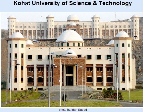
Figure 1.17 Kohat University of Science and Technology
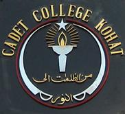
Figure 1.18 Seal of Cadet College Kohat
Healthcare Facilities; Kohat district
The following table shows the Government Health Care Institutions in Kohat district as per KP Development Statistics 2018-19:
| Institution | No./Beds | Institution | No./Beds |
| Hospitals | 07/522 | Dispensaries | 17/- |
| Rural Health Centers | 04/88 | Basic Health Units | 29/- |
| Mother Child Health Centers | -/- | Sub-Health Centers | 03/- |
| Leprosy Clinic | 01/- | TB Clinics | 01/- |
| Private Hospitals | -/- | Private Medical Practitioners | 54 |
Table 1.13 Kohat Health Institutes
Policing; Kohat district
The District Police Officer (DPO) Kohat is in-charge of policing Kohat district. The DPO reports to the Deputy Inspector General Police who in turn reports to the district Co-ordination Officer. In Kohat district there are 13 police stations.[3]
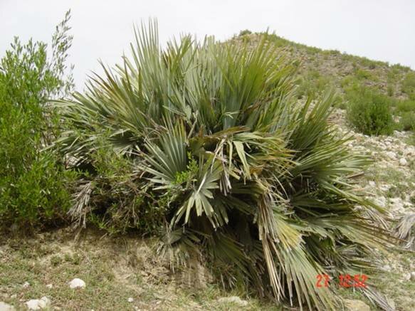
Figure 1.19 Mazri Palm
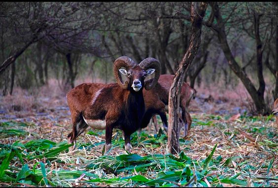
Figure 1.20 Urial in Kotal Wildlife Reserve, Kohat Pakistan.
[1] Kohat University of Science & Technology (KUST), and Preston University, Kohat Campus (Private)
[2] Khyber Medical University
[3] KP Development Statistics 2018-19
Environment and Biodiversity; Kohat district
Since there is very little industry, the only source of air pollution is dust and vehicular emissions.
Flora and Fauna; Kohat district
Flora; Kohat district
The most common trees of the district include ber (Zizyphus nummalaria), gurgura (Monotheca buxifolia), sanatha (Justicia adhatoda), phulai (Calotropis procera), wild olives (Olea ferruginea), shapianga or paneer dodi (Withania coagulans), hop bush (Dodonaea viscosa), harmal (Rhazya stricta; Peganum harmala), adaipashtawar/Himalayan abelia (Abelia Trifolora), mesquite (Prosopis spicigera), pomegranate/anar (Punices granatum), bedar/common yew (taxus bacata), poplar/bhan (Populace euphratica), varieties of oak (quercus), maple (acer), honey mesquite (Prosopis glandulosa), and bird plum (Sageretia theezans).
Flowering plants include all kind of roses, kashmal (basil or Indian barberry), bougainvillea, gul-e-nargis (narcissus), gul-e-dawoodi (chrysanthemum), jasmine or chambeli and other seasonal flowers.
An Ethno-botanical study conducted for Kohat Pass in 2011 by Shehla Shinwari, Rahmatullah Qureshi, and Elias Baydoun gives the botanical and common names of nearly 60 plants in 49 genera and 30 families. Some of these trees, shrubs and herbs include ganda phool (T.Patula. L), dodak (Oleracous), chota Kulfa (Indicum), ban hajari (Tagetes minuta), bhang (Cannabis sativa), mulathi (Glycerrhiza glabra), Niaz bo (Ocimum bascilicum), and podeena or mint (Mentha longifolia).
Fauna; Kohat district
The mammals found in the district include hog deer, hare, jackal, wolf, fox, wild cat, Urial, Chinkara, blue bull, monkeys, porcupine, and mongoose.
Tanda Dam reservoir is a wintering area for small numbers of migratory waterfowl, most notably black-necked grebe, pea fowl, little egret, grey heron, ruddy shell duck, common teal, mallard, northern pintail, common pochard, tufted duck, black-winged stilt, black and grey frankolins, white-cheeked bulbul, see-see partridge, chakor, white-throated kingfisher (threatened), and bee-eater.
Reptiles include cobra, scorpions, and most of the reptiles and insects common to the Punjab.
Protected Wildlife Areas and Endangered Fauna; Kohat district
The following areas have been declared protected wildlife areas in the district:
- Tanda Wildlife Park; Kohat district: The total area of the park is 2,800 acres, and consists of Tanda Reservoir, which is on the Ramsar list of internationally important wetlands, with its catchments in Kohat. The fauna being protected in the park includes urial, chinkara, hog deer, jungle cat, jackal, hare, porcupine, fox, mongoose, and blue bull. Reptiles of the park include cobra and other snakes, and lizards. Avifauna includes black partridge, grey partridge, chakor partridge, see-see partridge, common crane, demoiselle crane, geese, grey heron, egret, little egret, white-cheeked bulbul, ducks, and swans
- Kohat/Kotal Wildlife Park: Established in 1989-1990 over an area of 150 acres, the park provides sanctuary to urial, chinkara, hog deer, black partridge, grey partridge, and chakor
- Government-owned and protected game reserves in Kohat district include Balyamin, Shawaki, Chukhtoo, Rakh Topi, Resi, Toi Banda, Kachai Marai, Gurzandi, Jabbar, Marchungee, Darmalak, and Dhoda. These provide protection to fox, hare, jackal, grey partridge, black partridge, chakor partridge, bee-eater, raptors, urial, and chinkara
- Community-owned and protected game reserves of Kohat district include Dhok Dheri, Dhok Lohran, Darbokach, Usterzai Payan, Kanra Cheena, Shamshattu, Soor Dag, Jatta Ismail Khan, Lak-Kana, Daresh Khel, Dowro/Algada, Darwazai Banda, Sumari Bala, Shazadi Banda, Kamar, and Dhandidal Khel
- Kandar Dam Reservoir (Kohat district)is another designated Ramsar Site of international importance