Share now
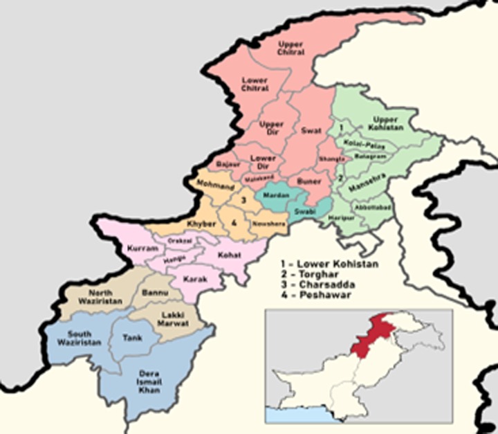
Map of Khyber Pakhtunkhwa; Mansehra Division Highlighted
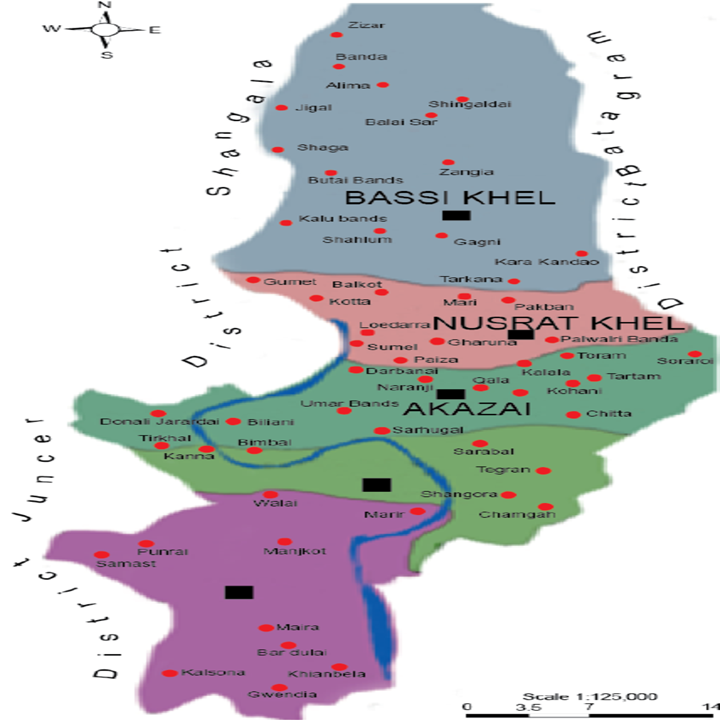
Map of Torghar District
Khyber Pakhtunkhwa Districts
- Peshawar District Profile
- Abbottabad District Profile
- Bannu District Profile
- Battagram District Profile
- Buner District Profile
- Charsadda District Profile
- Chitral District Profile
- Dera Ismail Khan District Profile
- Lower Dir District Profile
- Upper Dir District Profile
- Hangu District Profile
- Haripur District Profile
- Karak District Profile
- Kohat District Profile
- Kohistan District Profile
- Lakki Marwat District Profile
- Malakand District Profile
- Mansehra District Profile
- Mardan District Profile
- Nowshera District Profile
- Shangla District Profile
- Swabi District Profile
- Swat District Profile
- Tank District Profile
- Torghar District Profile
- Bajaur Tribal Distyrict Ptofile
- Khyber Tribal District Profile
- Kurram Tribal District
- Mohmand Tribal District Profile
- North Waziristan Tribal District Profile
- Orakzai Tribal District Profile
- South Waziristan Tribal District Profile
Also visit: Sindh, Punjab, Baluchistan
Introduction/Geographical Details; Torghar district
The district (formerly known as Kala Dhaka) is located between 34° 32Ꞌ to 34° 50Ꞌ north latitudes, and 72° 48Ꞌ to 72° 58Ꞌ east longitudes. The district is bounded on the south by Tanawal, on the east by Agror Valley (Mansehra), on the north by the River Indus across which lies Thakot of Battagram district, on the northwest (just beyond River Indus) by Shangla district, and on the southwest by Buner district. The northern part of the district is on the east of River Indus, while the southern part is on the west of the river.
Figure 1.4 View of Torghar District
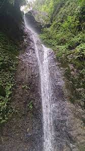
Figure 1.5 A Waterfall in Torghar District
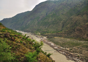
Figure 1.6 A View of Frontier Region (FR) Kala Dhaka
Torghar District at a Glance
| Name of District | Torghar District | |
| District Headquarter | Judba Town | |
| Population[1] | 171,395 persons | |
| Area[2] | 454 km2 | |
| Population Density[3] | 366.9 persons/ km2 | |
| Population Growth Rate[4] | -0.1% | |
| Male Population[5] | 50.3% | |
| Female Population[6] | 49.7% | |
| Urban Population[7] | – | |
| Tehsils/Talukas |
02 Tehsils and 16 Union Councils: 1. Judba Tehsil 2. Khander Tehsil |
|
| Main Towns/Villages | Judba, Mada Khel, Mangri, Khamisar, Basi Khel, Lashora, Maira Akazai, Kotli Nasrat Khel, Tilli, and Darbani | |
| Literacy Rate[8] | 23.0% | |
| Male Literacy Rate[9] | 46.0% | |
| Female Literacy Rate[10] | 6.0% | |
| Major Economic Activity[11] | Agriculture with its Allied Livestock Breeding & Fishing | 46.8% |
| Community Services | 18.2% | |
| Construction | 12.6% | |
| Transport | 8.6% | |
| Wholesale/Retail & Hotel/Restaurant | 9.0% | |
| Manufacturing | 2.4% | |
| Others | 2.4% | |
| Main Crops[12] | Wheat, maize, rice, barley, tobacco, rapeseed and mustard, fodder, soy bean, maash, masoor, moong, sugarcane, canola, and tea | |
| Major Fruits[13] | Citrus, banana, apple, guava, apricot, peach, pears, plums, loquat, walnuts, persimmon, mangoes, figs, and lychee | |
| Major Vegetables[14] | Onions, potatoes, tomatoes, garlic, peas, cabbage, carrots, radish, turnips, cauliflower, brinjal, cucumber, capsicum, mint, spinach and other leafy vegetables, French beans, and okra | |
| Forests (Area)[15] | Data NA | |
| Black Topped Road[16] | 120.0 km | |
| Shingle Roads[17] | 209.2 km | |
| No. of Grid Stations | Peshawar Electric Supply Corporation (PESCO) supplies electricity to the district. | |
| No. of Tel. Exchanges[18] | Data NA | |
| Industrial Zones[19] | Data NA | |
| Major Industry[20] | Data NA | |
| Household Size[21] | 6.7 persons per house | |
| Houses with Piped Water Inside[22] | 26.3% | |
| Houses with Electricity[23] | 49.1% | |
Table 1.1 Torghar District at a Glance
[1] 2017 Census.
[2] 1998 Census; 2017 Census uses spatial data.
[3] 2017 Census
[4] 2017 Census
[5] 2017 Census
[6] 2017 Census
[7] 2017 Census
[8] Pakistan Social & Living Measurement Survey 2014-15 (PSLM); latest available
[9] PSLM 2014-15
[10] PSLM 2014-15
[11] 1998 Census; Mansehra District, 1998 Data; 2017 Census data has not been made public yet.
[12] Mansehra District Data
[13] Mansehra District Data
[14] Mansehra District Data
[15] KP Development Statistics 2018-19; included in Mansehra District
[16] KP Development Statistics 2018-19
[17] KP Development Statistics 2018-19
[18] KP Development Statistics 2018-19
[19] KP Development Statistics 2018-19
[20] KP Development Statistics 2018-19
[21] 1998 Census; Mansehra District; 2017 Census data has not been made public yet
[22] 1998 Census; Mansehra District; 2017 Census data has not been made public yet
[23] 1998 Census; Mansehra District; 2017 Census data has not been made public yet
Brief History – Governmental Structure – Administrative Divisions – Historical/ Heritage Sites; Tourist Attractions
Brief History of Torghar District
Torghar (also spelled Tor Ghar) or Kala Dhaka or Black Mountains is both a mountain range and a former tribal area of Mansehra district. The Torghar (Black Mountain) massif is a series of spurs running up to a central, dominating ridge line, which reaches 9,817 ft (2,992 m) at its highest point, called the peak of Machai Sar. Along this ridge runs the line beyond which the British writ was not accepted, though the local tribes lived on both sides regardless. Kala Dhaka is located next to the Agror valley of Oghi area on its east, and by Tanawal on the south. In the beginning of the 14th century, the Tanoli tribe conquered the areas along the banks of the River Indus, which were later known as “Tanawal Area,” or “Tanoli Areas”. A picturesque site was picked for a capital near the river banks and named Amb. This principality of Tanawal, approved as a State by the British Government, became the Amb State. The State of Amb or Tanawal Area is located on the south of Kala Dhaka. The Nawabs of Amb State established strong relations with the tribes inhabiting Kala Dhaka.
According to the Imperial Gazetteer of India:
The range has a length of 25 to 30 miles from north to south and a height of 8,000 feet above sea-level. The River Indus flows along its northern boundary from where it turns south. Between the River and the crest of the range, the western slopes were occupied by the Yousafzai Pathans, the rest of the range was held by the Swatis or tribes who were driven from Swat by the Yousafzais. (v. 8, p. 251)
The Yousafzai Pathans are divided into tribes called Mada Khel, Hassanzai, Akazais, and Chagharzais. These tribes were independent, and were not brought under direct British Rule. They were under the influence of the Nawabs of Amb and the Wali of Swat, but these Nawabs exercised only nominal power over them. The area was generally accounted to be part of the Frontier Region (FR)/ Provincial Tribal Areas from around 1901 and nominally attached to the then Hazara district. The tribes had been involved in fighting the British for some time, and a number of famous Black Mountain Expeditions or Campaigns took place between 1852 and the 1920s. A brief account of the British Expeditions against the Torghar Tribes is as follows:
- Under Lieutenant Colonel F. Mackeson, in 1852-53, against the Hassanzais: The expedition was undertaken due to the murder of 2 British customs officers in 1851 within the borders of Tanawal, allegedly by the Hassanzai sect of the Yousufzai. A force of 3,800 British troops traversed their country, destroying their villages, grain, and crops
- Under Major-General A. T. Wilde, in 1868: This expedition was undertaken by the British after an attack on a British police post at Oghi in the Agror Valley by Yousafzai Pathans instigated by the Khan of Agror, but the British were repulsed. Further attacks on the troops of the Khan of Tanawal, who remained loyal, followed. This culminated in a general advance of the Black Mountain (Torghar) Tribes against the British position. It was repulsed, but not until 21 British villages had been burnt, and a second expedition under General Wilde had overrun the Black Mountain and secured the full submission of the tribes. A force of 12,544 British troops entered the country and the tribes made peace
- The First Hazara Expedition in 1888: The cause of this expedition was the constant raids made by the tribes on villages in British territory, culminating in an attack on a small British detachment, in which 2 English officers were killed. A force of 9,416 British troops was sent, and the tribes were severely punished for their “insurgence”
- The Second Hazara Expedition of 1891: In 1890 the tribesmen opposed the march of troops along the crest of the Black Mountain,and opened fire on them. A force of 7,300 British was sent in early 1891 in retaliation. The tribesmen made peace and entered into an agreement with the British Government to preserve the peace of the border. Immediately after the withdrawal of the troops, the Hindustanis and Madda Khels broke their agreement with the British Government by permitting the return of Hashim Ali Hassanzai (the leader of the troops attacking the British force). A second expedition was dispatched in 1892 which resulted in the complete pacification of the Black Mountain border.
After Partition, Torghar was given the status of Provincially Administered Tribal Area (PATA). It remained under the administrative control of the North West Frontier Province (NWFP) now Khyber Pakhtunkhwa (KP). Torghar became the 25th district of KP on 28 January 2011.
Torghar/ Kala Dhaka is made up of 5 tribal divisions named after the Pashtun tribes that claim respective ownership of the land. From north to south, these divisions are: Basi Khel, Nusrat Khel, Akazai, Hassanzai, and Mada Khel. The Basi Khel, Nusrat Khel, Akazai, and Hassanzai claim ownership of lands on both sides of the Indus River. The tribal lands of the Mada Khel are concentrated exclusively on the west bank of the Indus. All of the Kala Dhaka tribes lost large amounts of arable bottom land to the reservoir that was formed with the completion of the Tarbela Dam in 1975. Additional land and irrigation infrastructure was lost in the early 1980s when the Frontier Works Organization cut the alignment of the Darband-Thakot road along the east bank of Kala Dhaka. This loss of traditional lands and livelihoods to a combination of administrative fiat and the contingencies of modern infrastructure development lie at the heart of the Kala Dhakans’ mistrust of the Pakistani Government and its developmental initiatives. At the same time, roads remain a village priority, and a prerequisite to area development. Most of the men of the district migrate to Karachi for livelihood.
The district was badly affected due to the earthquake of 2005, when entire villages were wiped off. The people of Torghar rebuilt their houses on self-help basis, since Government help could not reach them.
Governmental Structure; Torghar District
At the Federal level, Torghar district is allocated a set number of representatives in both the National Assembly and the Provincial Assembly:
- Number of seats in the National Assembly 1
- Number of seats in the Provincial Assembly 1
Under the Local Government Act, District Torghar has 1 District Council constituted by general seats, seats reserved for women, peasants/workers, youth, and non-Muslims as prescribed under the Khyber Pakhtunkhwa Local Government Act 2013. Torghar District Council is composed of 15 general members, 5 women members, 1 peasants/worker member, 1 minority member, and 1 youth member.
Administrative Divisions; Torghar district
The district has a total area of 454 km2 and is divided into 2 Tehsils and 16 Union Councils as follows:
| Judba Tehsil | 07 Union Councils |
| Khander Tehsil | 09 Union Councils |
| Total | 16 Union Councils |
Table 1.2 Torghar Administrative Divisions
Historical/Heritage Sites; Tourist Attractions; Torghar district
Data regarding archaeological sites/ heritage buildings in Torghar district is not available.
The natural beauty and good climate is the chief tourist attraction of the district. Lush green valleys, gushing streams, thick forests, snow covered peaks, fertile gazing fields and abundant natural resources and the beautiful banks of Tarbela Dam are the key elements which attract tourists to the Torghar area. Once developed, the area can be proved another “Switzerland of Pakistan.” Machair Sar, for example, can become the main tourist spot of the district.
Topography of Torghar District
Torghar, formerly known as Kala Dhaka, is a rugged, mountainous region of approximately 500 miles2 (804 km2) straddling River Indus on both banks in the watershed of the Kala Dhaka Mountain Range. A 2,500 m high rugged ridge runs along the northeastern boundary of the district. From this ridge, land slopes down to the west in a series of lateral spurs which extend to the Indus River. A ridge also runs along the western side of the river, in the southern portion of the area. This ridge, averaging about 2,000 m elevation, is an extension of the Mahaban Range, which runs south to north for approximately 30 miles (48 km) between the river port of Darband and Thahkot (a bazaar on the Karakorum Highway) located in the Gadoon-Amazai Tribal Area of Swabi district, and is intersected in the middle by the Chamla River.
The mountain may be described as a long, narrow ridge with higher peaks at intervals, and occasional deep passes; the general outline of the crest is more rounded than sharp. From the sides, numerous large spurs project, which are often precipitous and rocky, with deep, narrow glens or gorges lying between them, in which some of the smaller villages of the tribes are located. The larger villages are, as a rule, situated on the banks of the Indus. The whole of the upper portion of the mountain is thickly wooded. The crest of the mountain is crossed by several passes. The highest peak of Kala Dhaka Mountain Range is called Machai Sar at an elevation of 9,817 ft (2,992 m) from sea level.
The Black Mountain (part of the Hindu Kush Mountain Range) has a total length of 20 to 25 miles (32 to 40 km), and an average height of 2,438 meters. It rises from the Indus Basin near the village of Kiara up to the watershed by Bruddur, where it runs northwest by north to the point on the crest known as Chittabut. From Chittabut the range runs due north, finally descending by 2 large spurs to the Indus again.
The Black Mountain Crest is crossed by several passes.[1] Some of the passes on Black Mountain are Pabal Gali at a height of 1,942 m, and Panj Gali at a height of 2,210 m.[2]
The land consists mostly of steep hillsides, with narrow terraces in places where rock outcrops are not too severe. On the lower slopes, the gradient is not as steep and larger areas of farmland are available. Many steep-sided valleys dissect the region. There are 7 main water courses entering the Indus from the left bank, and 3 from the right bank.
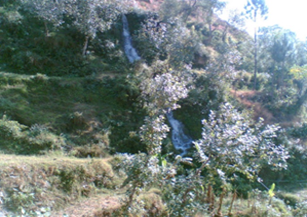
Figure 1.7 A Spring in Mountains of Kala Dhaka
Rivers, Streams and Lakes; Torghar district
River Indus flows along the district’s northern boundary, and a large number of streams/ nullahs originate from the mountains of Kala Dhaka, and flow down the mountains. Some of these flow down in the form of waterfalls. These provide water for both irrigation and domestic uses.
Some of the nullahs originating from the hills and providing water for irrigation are Mahabra Nullah, and Maira Nullah, among others.
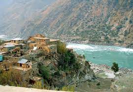
Figure 1.9 River Indus near Kala Dhaka
Forests; Torghar district
Mansehra (of which Torghar was a part) is one of the most enriched forest territories. Most of the forests are either reserved or guzara. Guzara forests are managed by the Forest Department which regulates the removal of timber for commercial as well local use. There are 3 main types of forests in Kala Dhaka; these are:
- Pure fir and spruce; above 8,000 ft (2,438 m). In areas that have been previously exploited, the crop is quite depleted
- Mixed fir, spruce and blue pine; 4,500 to 8,000 ft (1,372 to 2,438 m). These forests have been severely depleted in the past, and are now often found only in inaccessible areas
- Pure blue pine forests; 4,500 to 8,000 ft (1,372 to 2,438 m). These are the largest forests in terms of size/ area covered
Some of the forests of the district are Bilandkot, Saidra, Pirari, Gantar, Nasrat Khel, Pabalgali, and Akazai.[3]
Since no data is available for Torghar district, the following table shows the area and type of forests in Mansehra district (KP Development Statistics 2018-19):
| Total Forest Area | 536,423 A | Resumed Land | 29,142 A |
| Reserved Forests | 84,809 A | Communal Forests | – A |
| Protected Forests | 6,765 A | Guzara Forests | 150,937 A |
| Un-classed Forests[4] | 175,712 A | Private Plantation | 88,378 A |
| Miscellaneous | 680 A | Linear Plantation | 274 km |
Table 1.3 Torghar Forests
Soils of Torghar district
The soils of the district consist mainly of silt loam to silty clays, non-calcareous to slightly calcareous, and some rock outcrops of humid mountainous regions.[5]
Climate of Torghar district
The climate of Torghar is very fine in spring and autumn, but winters are severe because of the snowfall, which occurs in sufficient quantity to stop communication over the crest. Due to its proximity to the Sulky Valley of the Indus, the heat in the summer in the region, even at the highest elevations, is nearly as high as that experienced in the plains. Heavy rain generally falls in the spring and early autumn, and storms occur frequently.[6]
The district is a newly created district, and was a PATA of Mansehra district, known as FR Kala Dhaka. The climatic data of this district is, thus, not available and the data for Mansehra district is being repeated:
The climate of the district is warm in summer and cold in winter. The northern part i.e. the Kaghan Valley with surrounding high mountains is cold in summer and very cold in winter and receives heavy snowfall on the mountains. May to August are the summer months. The mean maximum and minimum temperatures during the month of June (the hottest month) are 35 °C and 21 °C. January is the coldest month with mean maximum and minimum temperatures of about 14 °C and 2 °C. Rainfall is less in northern part i.e. the Kaghan Valley as compared to the southern part i.e. Agror Konsh and Bhogarmang valleys. Average annual rainfall in the district is 1680 mm.
Seismic Activity/Seismicity; Torghar district
The district belongs to Zone 2B and Zone 3 of the Seismic Zone Map of Pakistan, which means moderate to severe damage due to earthquakes. It was one of the districts that were badly affected by the 2005 earthquake that hit both Kashmir and KP.
[1] Wylly H.C. From the Black Mountain to Waziristan, (p. 24-53)
http://www.archive.org/details/fromblackmountai00wyll
[2] Compiled by the Intelligence Branch, Division of the Chief of Army Staff, Army Headquarters India. Frontier and Overseas Expeditions from India. (v. I, p. 94) http://www.archive.org/details/frontieroverseas01indi
[3] Final Report on Kala Dhaka Area Oct. 1987. Special Development Unit, Planning and Development Department, NWFP (now KP).
[4] un-classed Forests are owned by the Government
[5] In the absence of separate data for Torghar, Mansehra district data has been repeated here
[6] Compiled by the Intelligence Branch, Division of the Chief of Army Staff, Army Headquarters India. Frontier and Overseas Expeditions from India. (v. I, p. 94) http://www.archive.org/details/frontieroverseas01indi
Population of Torghar District
The following table shows the population of the district as per the 2017 Census:
| District |
Area km2 |
Population | Male% | Female% |
Urban % |
Growth Rate% |
| FR Kala Dhaka/ Torghar District | 454 | 171,349 | 50.2 | 48.8 | – | – 0.1 |
| Judba Tehsil | 149 | 96,888 | ||||
| Khander Tehsil | 305 | 74,461 |
Table 1.4 Torghar Population Statistics
Religions; Torghar district[1]
| Muslims | 99.8% |
| Christians | Negligible % |
| Hindus | Negligible % |
| Ahmadis | 0.1% |
| Schedule Castes | Negligible % |
| Others | 0.2% |
Table 1.5 Torghar Religions
Languages; Torghar district[2]
| Urdu | 0.3% |
| Punjabi | 0.1% |
| Sindhi | 0.1% |
| Pushto | 26.6% |
| Balochi | Negligible % |
| Seraiki | 0.1% |
| Others | 72.9% |
Table 1.6 Torghar Languages
The other language spoken in the district is Hindko.
[1] 1998 Census; Mansehra District; ; 2017 Census data has not been made public yet
[2] 1998 Census; Mansehra District; 2017 Census data has not been made public yet
Economic Activity – Economic Infrastructure
Economic Activity; Torghar District
Separate data for Torghar district is not available; it is known that the economy of Mansehra district (of which Torghar was a Tehsil) is mainly based on agriculture with its allied livestock breeding & fishing (46.8%). Other activities include:[1]
- Construction (12.6%)
- Community Services (18.2%)
- Transport (8.6%)
- Wholesale, Retail, Trade and Hotels (9.0%)
- Manufacturing (2.4%)
- Others (2.4%)
[1] 1998 Census; 2017 Census data has not been made public yet.
Land Use; Torghar district
No separate data for the land use statistics of Torghar district is available; the total area of Torghar district is 454,000 HA.
Irrigation Network; Torghar district
River Indus and the hill torrents, streams, and springs are the main sources of irrigation water.
The following table shows the mode and area irrigated by each mode, in absence of separate data for Torghar district data for Mansehra district is reproduced (KP Development Statistics 2018-19):
| Total Irrigated Area | 19,164 HA | Canal Irrigated (Private) | 12,007 HA |
| Tube Wells | 12 HA | Canal Irrigated (Govt.) | 7,145 HA |
| Wells | – HA | Lift Pumps/Others | -HA |
Table 1.9 Torghar Irrigation Statistics
Agriculture; Torghar district
Torghar district can be divided into 3 distinct Agro Ecological Zones that extend from 5,000 to 6,000 ft (1,524 to 1,829 m) above sea level to the ridgeline:
- Subalpine Pastures
- Evergreen Forests
- River Valleys of the Highlands
The area lacks sufficient agricultural land to meet the subsistence requirements of its population. Most households supplement their agricultural production by keeping livestock for milk and meat; the region’s abundant grasslands and pastures support a large number of livestock compared to other mountainous areas of Pakistan.
In absence of other data, Mansehra district’s data is reproduced here. Accordingly, the crops of the district include wheat, maize, rice, barley, tobacco, rapeseed and mustard, fodder, soy bean, maash, masoor, moong, sugarcane, canola, and tea. The fruits grown are citrus, banana, apple, guava, apricot, peach, pears, plums, loquat, walnuts, persimmon, mangoes, figs, and lychee. The vegetables are onions, potatoes, tomatoes, garlic, peas, cabbage, carrots, radish, turnips, cauliflower, brinjal, cucumber, capsicum, mint, spinach and other leafy vegetables, French beans, and okra.
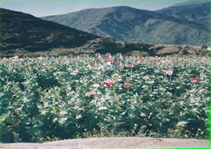
Figure 1.10 A Poppy Field, Torghar
Livestock Breeding; Torghar district
The following table shows the statistics of livestock for Mansehra district[1] (2006 Census of Livestock, qtd. in KP Development Statistics 2018-19):
| Cattle | 181,973 Heads | Buffalo | 191,064 Heads | Sheep | 86,729 Heads |
| Goats | 316,759 Heads | Camels | 1,676 Heads | Horses | 7,906 Heads |
| Mules | 4,393 Heads | Asses | 36,061 Heads |
Table 1.7 Torghar Livestock Statistics
Kaghani, and gaddi breeds of goats are indigenous breeds of livestock in the district.
Poultry Farms; Torghar district
There are 243 poultry farms[2] in the district.
Fishing; Torghar district
The River Indus and other smaller rivers and streams provide ample opportunity for development of fisheries in the district.
Industry and Manufacturing; Toghar district
At present there is no industry in the district.
Mining; Torghar district
According to the Report on Kala Dhaka, Oct. 1987 by Special Development Unit, Planning and Development Department NWFP (now KP):
In the Hazara District the following minerals have been reported: pyrites, graphite, marble, mica and asbestos. Within the Kala Dhaka area, a detailed survey has yet to be carried out although preliminary field visits by officers from Geological Survey of Pakistan indicate the following incidences: i) White marble – Thakot and adjoining areas; ii) Lead, Zinc, Magnetite – From Besham to Banda; iii) Beryl – Rajolawari; iv) Soap stone/Talc – Checker; v) Feldspar/partry clay, Ahal, Mansehra; vi.) Barite -Kand Saider; Other minerals reported to be found in the area are Mica and Bauxite. (p.3)
Trade (Import/ Export); Torghar district
No data available.
Handicrafts; Torghar district
No data available.
[1] Separate data for Torghar district is not available
[2] Table 17, No. of Commercial Poultry Farms and Number of Birds in Pakistan; Data for Mansehra district
Economic Infrastructure; Torghar district
The Torghar district lacks communication infrastructure. There are a few steep and narrow roads, but distant places lack any kind of economic infrastructure. It can take a whole day to reach the nearest town of Oghi in district Mansehra from many areas of Torghar.
Road Statistics; Torghar district
According to the KP Development Statistics 2018-19 the road statistics of the district[1] are as follows:
| Total Roads | 329.2 km |
| High Type Roads | 120.0 km |
| Low Type Roads | 209.2 km |
Table 1.8 Torghar Road Statistics
The only road that traverses Kala Dhaka from Darband to Thakot connects the area with other parts of Pakistan.
Other roads in the district are
- Darband to Thakot Road
- Khanano Dheri (Buner District) to Manjakot (not completed yet)
- Petao Amazai (district Shangla) to Mada Khel (not completed yet)
- Shugli Bandi Oghi to Tilli Saydan Hasanzai
- Oghi Choor Kalam to Machai Sar
- Gijborri (Batagram district) to Mangri and Kamasir
- Kotgala (Batagram district) to Bartooni
- Topi (district Swabi) to Teetay Madakhail (the best way to travel to Kala Dhaka)
- Dilbori to Miran
- Beland Kot to Sonchal
Rail and Airways; Torghar District
There is no railway station in the district. The nearest railway station is at Havelian, Abbottabad. The nearest commercial airport is located in Mansehra city.
Radio and Television; Torghar district
Television broadcasts cannot be viewed in the district.
Telecommunications; Torghar district
The data for telecommunication Services is included in the Mansehra District.
Post Offices; Torghar District
There is one sub-post office in the district[2].
Electricity and Gas; Torghar district
Peshawar Electric Supply Corporation (PESCO) provides electricity to the district. Gas for domestic use is not available.
[1] Data for Mansehra District
[2] KP Development Statistics 2018-19
Banking/ Financial Services; Torghar district
There is one branch of Bank of Khyber in the District.
Educational Institutions; Torghar district
The literacy rate of the district is 23.0%. Following table shows the statistics of educational institutions in Torghar district (Khyber Pakhtunkhwa Development Statistics 2018-19).
| Institution | Boys/Girls | Institution | Boys/Girls |
| Primary Schools | 133/61 | Middle Schools | 23/02 |
| High Schools | 04/- | Higher Secondary Schools | 03/- |
| Mosque Schools | 10 | Degree Colleges | -/- |
| Polytechnic Institutes | – | Commerce Colleges/ Institutes | -/- |
| Vocational Centers | – | Private Primary Schools | – |
| Private Schools (Middle + Secondary) | – | Post Graduate College | – |
| University[1] | – | Medical/ Engineering Colleges | – |
Healthcare Facilities; Torghar district
The following table shows the Government Health Care Institutions in Mansehra district[2] as per KP Development Statistics 2018-19:
| Institution | No./beds | Institution | No./beds |
| Hospitals | 12/651 | Dispensaries | 59/- |
| Rural health Centres | 08/162 | Basic Health Units | 59/- |
| Mother Child Health Centres | 03/- | Sub-Health Centres | – |
| Leprosy Clinic | 05/- | TB Clinics | 01/- |
| Private Hospitals[3] | 02 | Private Medical Practitioners | 163 |
Table 1.10 Torghar Health Institutes
Policing; Torghar district
Jirga (traditional, tribal) law is still enforced by individual tribes, although they sometimes ask the law enforcment agencies (Political Tehsildar) to arbitrate on major disputes over cases of murder. The Political Tehsildar, as the official who deals directly with the tribes, is also consulted on issues raised by the Government such as the payment of compensation for acquired land for construction of roads, land for Basic Health Units (BHU), and schools. Generally, the region, apart from tribal law, is lawless, since there is no police force, and proclaimed offenders can seek sanctuary in the mountainous areas of Torghar. They can only be apprehended through negotiations between the District Administration and the tribal chiefs. A Frontier Constabulary fort has been set up on the border of the area in the northern region, near Chor Kalam. Its main purpose is to protect villages from raiding parties from Kohistan, and to protect the nomadic Gurgars from local bandits.[4] According to KP Development Statistics 2018-19 there are 03 Police Stations in the District.
[1] Campus of Abdul Wali Khan University, Mardan
[2] No data is available for Torghar district
[3] Saad Hospital and Sher Khan Hospital
[4] Report on Kala Dhaka, Oct. 1987, Special Development Unit, Planning and Development Department NWFP (now KP)
Environment and Biodiversity; Torghar District
The district is free from industrial pollution and other pollutants as it is devoid of industry. The Torghar Mountains have traditionally been used for trophy hunting which destroyed the wildlife of the area. In order to try and conserve the critically endangered Suleiman Markhor and Afghan Urial, a Non-Governmental Organization (NGO) called Society for Torghar Environmental Protection (STEP) was formed in 1985 and due to its conservancy efforts, this area now boasts the largest population of these mammals.
Flora and Fauna; Torghar district
Flora; Torghar district
The district hosts a large number[1] of herbs many of which are used for medicinal purposes locally as well as outside the district. The flora of the district varies from place to place due to variation in height and rainfall. The most common broad leaved trees are walnut (Juglans regia), Narri (Acanthus), eucalyptus (Eucalyptus), kikar, or babool (Acacia), chestnut (Castanea), bird-cherry (Prunus padus), yew (Taxus baccata), wild olive (Olea oleaster), ash (Fraxinus), plane tree (Platanus), alder (Alnus), Persian lilac (Melia azedarach), elm (Ulmus), mulberry (Morus alba), and many species of willow (Salix), poplar (Populus), birch (Betula) and occasionally juniper (Juniperus) are found in the higher parts. Among the conifers are pine (Pinus), deodar (Cedrus deodara), blue pine (Pinus wallichiana), spruce (Picea) and silver fir (Abies alba).
The common shrubs and herbs of the area are sanatha (Dodonea viscosa), phulai (Acacia modesta), wild indigo (Baptisia), valerian (Valeriana officinalis), peony (Paeonia), sorrel (Rumex acetosa), timar (Zanthoxylum alatum), ber (Zizyphus), hawthorn (Crataegus), oleaster (Oleo Europa), wayfaring (Viburnum lantana), barberry (Berberis), bramble (Rubus) and others.
Sunflower, rose, jasmine, jasmine-zambak, narcissus, tulip, lily, dog violet, brush flax, iris, and musk-rose are some of the ornamental flowering plants of the district.
Some medicinal herbs include sultani booti (Achillea millefolium Linn.), arusha (Adhatoda vasica), horse chestnut (Aesculusindica Wall), kori booti (Ajuga bracteosa), Pakistani aloe (Aloe barbadensis Mill), green amaranth (Amaranthus viridis), shakakul (Asparagus racemosus), and bhang (Cannabis sativa).
Fauna; Torghar district
The mammalian fauna of the district includes leopard, porcupine, black bear, jackal, wild goat, brown bear, wolf, barking deer, rhesus monkeys, langur, musk deer, flying squirrel, and wild boar.
Avifauna includes several species of herons, teals, doves, cuckoos, bee-eaters, woodpeckers, larks, shrikes, bulbuls, finches, wagtails, swallows, parrots, mynas, pigeon, sparrows, hoopoe, kingfishers, crows, western-horned tragopan, imperial monal pheasant, and koklas pheasant are found only in hilly areas, while black and grey partridges as well as quails are also common. The birds of prey are shikra, sparrow hawk, owl, and several species of vultures.
A variety of snakes and lizards like cobras, Indian kraits, sang choor, rat eaters, Pakistani agama, spiny-tailed lizards, brown turtles, frogs, and common toads are the common reptiles and amphibians of the area.
Protected Areas and Endangered Fauna; Torghar district
No data for Torghar district is available, and thus, Mansehra data is reproduced below:
The largest bird sanctuary of Asia—Dodhial Pheasantry—is located in Dodhial, Mansehra district. This sanctuary houses and provides sanctuary to 38 types of pheasants, including re-introduction of cheer pheasant. This pheasantry is also providing breeding grounds to tigers, chinkara, urial, and other protected animals for their subsequent re-introduction to their habitats. The endangered koklas, monal, western tragopan, kalij, and cheer are provided sanctuary here.
Saiful Malook and Lalusar-Dodipat National Parks provide sanctuary to snow leopard, black bear, marmot, weasel, lynx, leopard, Himalayan snow cock, and snow partridge.
Game Reserves (both Government-owned and community-owned and protected) of the district include Makhnial Game Reserve, Palsala Dhanaka, Battal, Pharhana, Karair, Khawajagan, Lassan Thukral, Sheikhabad, Bhalli Ghatti, Behali, and Jallo, all these Game Reserves provide sanctuary to barking deer, kalij pheasant, chakor partridge, and black partridge.
[1] Data for Mansehra