Share now
Map of FATA

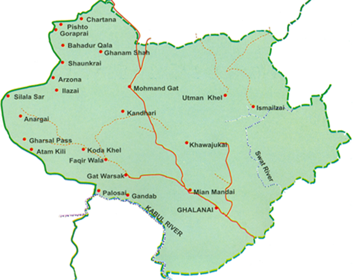
Map of Mohmand Tribal District
Khyber Pakhtunkhwa Districts
- Peshawar District Profile
- Abbottabad District Profile
- Bannu District Profile
- Battagram District Profile
- Buner District Profile
- Charsadda District Profile
- Chitral District Profile
- Dera Ismail Khan District Profile
- Lower Dir District Profile
- Upper Dir District Profile
- Hangu District Profile
- Haripur District Profile
- Karak District Profile
- Kohat District Profile
- Kohistan District Profile
- Lakki Marwat District Profile
- Malakand District Profile
- Mansehra District Profile
- Mardan District Profile
- Nowshera District Profile
- Shangla District Profile
- Swabi District Profile
- Swat District Profile
- Tank District Profile
- Torghar District Profile
- Bajaur Tribal Distyrict Ptofile
- Khyber Tribal District Profile
- Kurram Tribal District
- Mohmand Tribal District Profile
- North Waziristan Tribal District Profile
- Orakzai Tribal District Profile
- South Waziristan Tribal District Profile
Also visit: Sindh, Punjab, Baluchistan
Introduction/Geographical Details, Mohmand Tribal District (TD)
Mohmand District derives its name from the Mohmand tribe which inhabits the area. The Tribal District (TD) is located between 33° 30Ꞌ to 34° 40Ꞌ north latitudes and 70° 30Ꞌ to 71° 30Ꞌ east longitudes. It is bounded on the north by the Bajaur Tribal District, on the east by Malakand Protected Area/ district and Charsadda district, on the southeast by Peshawar district, on the south by Khyber Tribal district and on the west by Afghanistan.
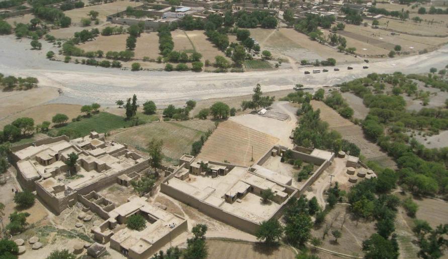
Figure 1.3 An Aerial View of a Village in Mohmand District
Mohmand Tribal District at a Glance
| Name Of Tribal District | Mohmand Tribal District | |
| Headquarters | Ghalanai | |
| Population[1] | 466,984 persons | |
| Area[2] | 2,296 km2 | |
| Population Density[3] | 203.4 persons/ km2 | |
| Growth Rate[4] | 1.8% | |
| Male Population[5] | 50.9% | |
| Female Population[6] | 49.1% | |
| Urban Population[7] | – | |
| Administrative Units |
07 Tehsils: 1. Ambar Utmankhel Tehsil 2. Halimzai Tehsil 3. Pindiali Tehsil 4. Pranghar Tehsil 5. Safi tehsil 6. Upper Mohmand Tehsil 7. Ekka Ghund Tehsil |
|
| Important Cities/ Places | Ghalanai, Mohmand Gat, Safi, Salimzai, Khwazai/ Baizai, Pandyalai, Prang Ghar, Ambar, Gandhab (Mian Mandi), Yekka Ghund, Lakaro, Danishkul, Khwezai, Ghanam Shah, and Qandharo | |
| Literacy Rate[8] | 26% | |
| Male Literacy Rate[9] | 52% | |
| Female Literacy Rate[10] | 7% | |
| Major Economic Activity[11] | Economic Activity figures for FATA are not available, but subsistence level agriculture with its allied livestock breeding and fishing is the major employer. Other activities include small scale businesses, mining, and elementary occupations. Immigration to other districts in search of jobs to send remittances home is a major economic activity | |
| Main Crops | Wheat, maize, rice, jowar, sugarcane, moong, gram, barley, rapeseed & mustard, poppy, tobacco, etc. | |
| Major Fruits | Water melon, musk melon, apricots, apples, peach, plums, citrus, persimmon, dates, etc. | |
| Major Vegetables | Onions, tomatoes, peas, radish, okra, tinda, brinjal, pumpkin, bitter gourd, bottle gourd, etc. | |
| Forests (Area)[12] | 10,006 HA[13] | |
| Black Topped Roads[14] | 476.4 km | |
| Shingle Roads[15] | 131.1 km | |
| Electricity | Tribal Agency Electric Supply Corporation (TAESCO) looks after supply and transmission of electricity. No other data is available. | |
| Telephone Exchanges[16] | 04 Telephone exchanges with 1,108 connections | |
| Industrial Zones[17] | No Industrial estate but 227 registered Industrial Units in the tribal district, out of which 178 are working and 50 units are closed | |
| Major Industry and No. of Industrial Units[18] | Sporting & Light Hunting Arms | 4 Units |
| Cement Blocks | 9 Units | |
| Food & Beverages | 4 Units | |
| Stone Crushing | 2 Units | |
| Flour, Green Chips, Making Chips, Scrap Steel, Shoes, Stone Grinding, Washing Powder | 1 Unit Ea. | |
| Ammunition, Furniture | 2 Units | |
| Lining Acid, Soaps, Talcum Powder | 3 Units Ea. | |
| Marble Stones | 100 Units | |
| Marble Tiles | 44 Units | |
| Pots Powder | 6 Units | |
| Powder | 38 Units | |
| Household Size[19] | 9 persons per house | |
| Houses with Piped Water[20] | 32% | |
| Houses with Electricity[21] | 57.9% | |
Table 1.1 Mohmand TD at a Glance
[1] 2017 Census
[2] 2017 Census
[3] 2017 Census
[4] 2017 Census
[5] 2017 Census
[6] 2017 Census
[7] 2017 Census
[8] Pakistan Social & Living Measurement Survey (PSLM) 2019-20
[9] Pakistan Social & Living Measurement Survey (PSLM) 2019-20
[10] Pakistan Social & Living Measurement Survey (PSLM) 2019-20
[11] Employment by Industry figures are not available for the former FATA
[12] KP Development Statistics 2018-19
[13] Forestry Statistics do not record any forest statistics
[14] KP Development Statistics 2018-19
[15] KP Development Statistics 2018-19
[16] KP Development Statistics 2018-19
[17] FATA Development Authority, Industries Survey Report, 2010 (Latest Available)
[18] FATA Development Authority, Industries Survey Report, 2010 (Latest Available)
[19] 1998 Census; 2017 Census data has not been made public yet
[20] 1998 Census; 2017 Census data has not been made public yet
[21] 1998 Census; 2017 Census data has not been made public yet
Brief History of the Tribal District (TD) – Governmental Structure – Administrative Divisions – Historic/ Heritage Sites, Tourist Attractions
Brief History of Mohmand Tribal District (TD)
Mohmand TD takes its name from the Mohmand tribe that inhabits it. The Mohmand tribe (also spelled as “Momand”) is a branch of Ghani Khel Afghans and originally lived in central Afghanistan between the basins of the Tarnak and Oxus Rivers for centuries. After the Mongols invaded the region in the 13th century AD, the Mohmands were driven out from central Afghanistan, and so, between the 13th and 15th centuries, they established their current settlements[1] in former Mohmand Agency. They were able to do so as, historically, they were ruled by hereditary chiefs or Khans who kept them united. This unity helped them gain strength in integrated numbers, and they successfully drove out other tribes. One of the clans claims that the chief of these Khans was the Khan of Lalpura (now a district in Afghanistan), but there were several minor Khans as well. Local historians claim that the “Khan” of the Mohmand tribe is the hereditary guardian of the sarishia or code of tribal law and customs. The Khans of Lalpura, over time, pledged allegiance at various times to the Mughal Emperors Akbar and Shahjahan, and to Nadir Shah and Ahmad Shah Durrani/ Abdali. In 1782, however, Arsala Khan of Lalpura revolted against Timur Shah Durrani/Abdali. He was compelled to submit, and was executed at Peshawar in 1791.[2] From this time to the annexation of Punjab and the Frontier by the British in 1849, historical accounts mostly record tribal warfare and constant bloodshed.
When the British formally annexed Peshawar in 1849, the areas that now comprise the current Mohmand TD were ruled by Saadat Khan of Lalpura, while the Khans of Bajaur ruled the Safi tribe residing in the northern portion of Mohmand country, as well as the Uthman Khel tribe who was independent of any Khanate.
Saadat Khan held the Khanship for 40 years, and was a faithful vassal of the Barakzai dynasty of Afghanistan, but in 1864, he was arrested by the Barakzai Amir on the instigation of the British. He died, a prisoner of the Barakzai Amir, at Kabul.
The Mohmands fought against the British who were never able to completely establish control over them. According to William Henry Paget[3] “the Mohmands during the early years of British Rule, in the Peshawar Valley gave more trouble than almost any another [sic] tribe” (v.1, p. 421).
After the annexation of Punjab in 1849, the Shabqadar fort (originally called Shankargarh)¾built in KP’s Charsadda district by the Sikhs to guard the town against the Mohmands (among other tribes)¾was taken over by the British who stationed regular troops in it. In 1885 the fort was handed over to the Border Military Force. The British fought many battles with the Mohmands using this fort as their base. In 1850 the Mohmands attacked the fort under the leadership of Fateh Khan, the son of Saadat Khan (who was still the Khan of Lalpura). This attack was repulsed. In 1851 the Mohmands again attacked British Posts. The British organized an expedition under Brigadier Sir Colin Campbell. This expedition lasted for nearly 6 months before any peace agreement with Mohmands could be signed.
The second expedition against the Mohmand tribe was sent by the British in 1854 led by Colonel Sydney J. Cotton. Many more expeditions followed in 1863-64, 1879, and 1880, as well as during the Great Pathan Uprising of 1897-98. More expeditions were sent in 1908 and 1935. In spite of these expeditions, the British were unable to establish dominance over the region.
In 1896 the jirgas (tribal courts) of all Mohmand clans formally tendered their submission to the Lieutenant Governor of the Punjab and were granted allowances. In 1902, Musakhel of Mittai, a section of the Baizai clan (of Mohmand) also joined this agreement.
In 1935 the Mohmands rebelled and started guerrilla warfare against the British again. The British organized a force called the Mohmand Force or Mohforce. In this battle, tanks were used for the first time in any expedition in India. This expedition ended when the Nahakki Pass and mountains were taken by the British troops.
In 1948, shortly after the Partition, the Mohmands signed an agreement to join Pakistan following a judgement of a jirga of elders.
At the time of Partition, the area was administered by the Deputy Commissioner based in Peshawar and Political Agent located in Khyber. In 1951 the area was upgraded and made an independent Agency.
When the Agency was given an Independent Agency Status in 1951, Moulvi Rasheeduddin was made its first Political Agent. Its headquarters was located in Peshawar and the city remained the Headquarters of the Agency till 1973, when it was shifted to Yekka Ghund located just within the borders of the Agency. In 1974 the headquarters was shifted to Ghalanai. At the time of Partition, the area from Subhan Khwar to Yekka Ghund Bazar was the territory of Mohmand Agency and the area extending from Yekka Ghund Bazar was called the free zone (Yaghistan), where there was no writ of the government. The Mohmand tribe made this area a part of district Charsadda. The government separated the Taragzai Tribe from Mohmand Agency by force and included it in Charsadda.
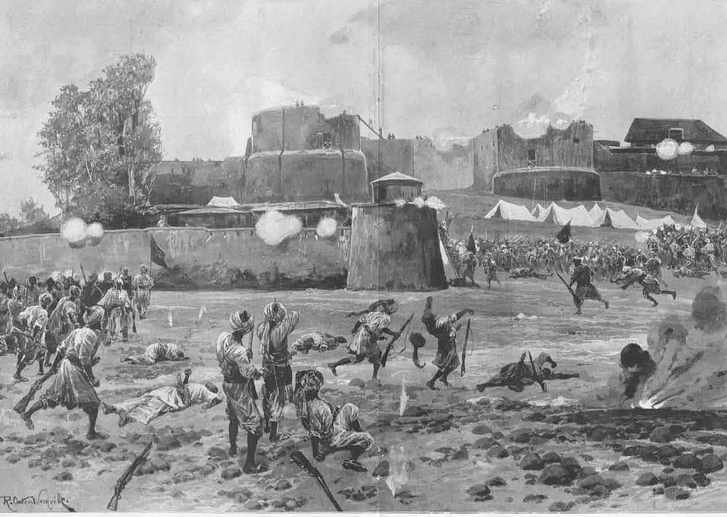
Figure 1.4 Attack on Shabqadar Fort on 7th August 1897: Mohmand Field Force, 7th August to 1st October 1897. Picture by Richard Caton Woodville
[1] Extracted District Profile Khyber Agency 1998; By then GONWFP
[2] Gazetteer of the North West Frontier Province 1908 p. 226
[3] Records of the Expeditions against the North West Frontier Tribes since the Annexation of Punjab by Army Intelligence Branch, 1907
Governmental Structure; Mohmand TD
At the Federal level, Mohmand Tribal district is allocated a set number of representatives in both the National Assembly and the Provincial Assembly:
- Number of seats in the National Assembly 1
- Number of seats in the Provincial Assembly 3
Under the Local Government Act, the Tribal District has 65 Councils, which include 58 Village and 7 neighbourhood Councils.
Administrative Divisions; Mohmand TD
Administratively, Mohmand Tribal District is divided into 07 Tehsils and 58 Village Councils and 07 Neighbourhood Councils as follows:
- Ambar Utmankhel Tehsill
- Halimzai Tehsil
- Pindiali Tehsil
- PranGhar Tehsil
- Safi Tehsil
- Upper Mohmand Tehsil
- Ekka Ghund Tehsil
Historic/ Heritage Sites, Tourist Attractions; Mohmand Tribal District
Some of the important and ancient buildings[1] which need government protection for their preservation include:
- Michni Fort, constructed by the British to fight against the Mohmand tribe. It is located in Michni near Warsak dam; Mohmand district
- Tomb of Haji Torangzai/ Ghaziabad. Haji Torangzai was a local freedom fighter. An annual Urs is celebrated every year in April; Mohmand district.
Other important tourist attractions of the TD are:
- Michni, near Warsak Dam, known for its scenic beauty; Mohmand district
- Ghalanai: This is the TD’s Headquarters and a scenic town; Mohmand district
- Khawazai: The area leading up to the Durand Line. It is accessible from Ghandab through Darra Khanch; Mohmand district
- Chamar Kand: A scenic tourist spot; Mohmand district
- Mandar Dam; Mohmand district
- Gandab Valley: This valley has a major bazaar with 200 shops. It is narrow, and barren, and touches the Durand Line, running parallel to the dry bed of a nullah; Mohmand district
- Yekka Ghund; Mohmand district: 2 km northwest of Yekka Ghund is an ancient route called the Caravan Route which connects the Indus and Oxus valleys. This route contains an ancient Sarai or a place of rest for travelers. The Sarai is rectangular in shape but the southern side has a semicircular bastion. Burnt bricks and stones were used in its construction. Coins bearing the Kalima (the Religious confession of Muslims) have been found here. It is believed that this is a construction of the Mughal period
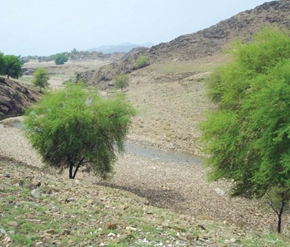
Figure 1.9 A Natural Stream in Mohmand TD
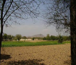
Figure 1.10 A Farm near the Durand Line
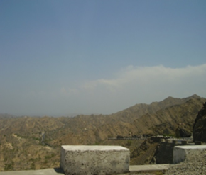
Figure 1.11 View of the Road near Ghalanai
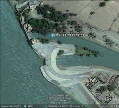
Figure 1.12 Munda Headworks on River Swat, Mohmand TD
[1] Study on Tourism Potential of FATA, FATA Development Authority
Topography Of Mohmand Tribal District
Mohmand TD is formed[1] by glens and rugged mountains with bare slopes between the towering peaks of the Hindu Kush and lowland basins. The general slope of the area is from north to east.
The Mohmand Hills include the Sapper Ranges, the Ilazai Hills and Malakand Hills:
- The Sapper Ranges are an extension of the Dir-Bajaur Ranges, which stretch to the north of the TD, forming a watershed between the TD and the Kunar River basin in Afghanistan
- The Ilazai Hills branch off from the Sapper Ranges, to the southwest of the TD. These hills first turn southeast and then follow an easterly direction, forming a watershed between various streams flowing in the east and south
- The Malakand Hills occupy the eastern part of the Mohmand TD. The slopes of these hills are barren with a thin cover of olive and oak trees
The Ilazai (2,716 meters) is the highest peak near the Pak-Afghan border. Other important peaks are Yari Sar (1,929 meters) and Silai.
The relatively flat area of Mohmand TD is composed of the Swat basin and the Kabul basin. The Swat basin is drained by the River Swat which enters the TD from the northeast, and the Kabul basin is drained by the Kabul River which flows along the southern fringe of the TD.
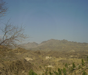
Figure 1.5 Barren Mountains in Mohmand TD
Rivers, Streams, and Lakes; Mohmand TD
The main rivers of the TD are the River Swat and River Kabul. The River Kabul forms the boundary between the Khyber and Mohmand TDs. The River Swat flows from the north to the south, and passes through the area of Prang Ghar in the Pindiali Tehsil.
A large number of streams/ nullahs originate in the mountains and traverse the TD. Some of the important nullahs include Rawalkor Khwar, Gandao Khwar, Danish Kool Rud (a tributary of River Swat), Ambahar Rud and Pindiali streams (both are tributaries of Danish Kool Rud), Gandab, Shalman, Salala, and Bara Darra.
Some of the intermittent streams include Spinkai Tangai, Shamsha Shan Darra, Shin Khwar, Khapak Khwar, and Gosarai Khwar. There are no lakes in the TD; rain water is stored in ponds for irrigation and domestic uses.
Forests of Mohmand TD
Since the TD has an arid climate, there are no green forests, as the forests of the TD are dry mountainous forests. The forests consist of shrubs and thorny bushes with some broad leaved trees growing on the lower altitudes. The principal species include babul, kikar, phulai, vann (acacia sp), wild olives (ole asp) and oak (quercus sp). In the areas where water is available, mulberry and poplar trees are also grown. There are no notable forests in the TD.
The following table shows the status of forests as per FATA Development Statistics 2013-14: (KP Development Statistics 2018-19 do not report data for the TD)
| Total Forest Area | 51,710 A | Man Made Forests | 43,489 A |
| Natural Forests | 8,031 A | Linear Plantation | 250 km |
Table 1.3 Mohmand TD Forests
Soils of Mohmand TD
The soils of the TD are shallow to moderately deep, slightly to moderately calcareous, coarse-textured (sand, loamy sand, sandy loam, fine sandy loam to loam) and slightly eroded. These occur on lower mountain slopes.
Piedmont alluvium plains consist of moderately deep, well-drained, moderately calcareous, and slightly eroded soils.
The soils are generally fertile and fit for growing crops, fruits, and vegetables.
Climate; Mohmand TD
The climate of the TD is hot in summers and cool in winters. The summer season commences from May and continues till August. The winter season starts from November and continues till February. The mean maximum and minimum temperatures for June are 38 °C and 28 °C, whereas the mean maximum and minimum temperatures for January¾the coldest month¾are 12 °C and 9 °C.
Rainfall is scanty, and most of it occurs in the winter season. The mean annual rainfall in the TD is 160 mm.
Seismic Activity/Seismicity; Mohmand TD
The Mohmand Tribal district belongs to Zone 3 of the Seismic Zone Map of Pakistan which
[1] Extracted from Socio-economic Profile of Mohmand Agency by USAID, 1993
Population of Mohmand Tribal District
The following table[1] shows the population of the TD as per 2017 Census:
| Tribal District |
Area km2 |
Population | Male% | Female% |
Urban % |
Growth Rate % |
| Mohmand Tribal District | 2,296 | 466,984 | 50.96 | 49.04 | – | 1.8 |
| Ambar Uthmankhel Tehsil | – | 62,109 | ||||
| Halimzai Tehsil | – | 78,002 | ||||
| Pindiali Tehsil | – | 88,363 | ||||
| Prang Ghar Tehsil | – | 35,290 | ||||
| Safi Tehsil | – | 99,114 | ||||
| Upper Mohmand | – | 51,068 | ||||
| Yekka Ghund Tehsil | – | 52,291 |
Table 1.4 Mohmand TD Population Statistics
Religions; Mohmand TD[2]
| Muslims | 99.8% |
| Christians | Negligible % |
| Hindus | Negligible % |
| Ahmadis | 0.2% |
| Scheduled Castes | Negligible % |
| Others | Negligible % |
Table 1.5 Mohmand TD Religions
Languages; Mohmand TD[3]
| Urdu | 0.1% |
| Punjabi | 0.1% |
| Sindhi | Negligible % |
| Pushto | 99.8% |
| Balochi | Negligible % |
| Seraiki | Negligible % |
| Others | Negligible % |
Table 1.6 Mohmand TD Languages
[1] Blank rows indicate that data was not available for those fields
[2] 1998 Census; 2017 Census Data results have not been released yet.
[3] 1998 Census; 2017 Census Data results have not been released yet.
Economic Activity – Economic Infrastructure
Economic Activity; Mohmand Tribal District
The local economy[1] is largely pastoral, with agriculture being practised in a few fertile valleys. Most people are engaged in subsistence level agriculture and livestock breeding as well as small businesses conducted locally. People mostly seek employment in other districts or outside Pakistan.
[1] Employment by Industry numbers for FATA are not available
Land Use; Mohmand TD
The following table shows the main land use statistics of Mohmand TD as per KP Development Statistics 2018-19:
| Total Area | 229,600 HA | Reported Area | 229,620 HA |
| Total Cultivated Area | 23,514 HA | Net Sown | 21,714 HA |
| Current Fallow | 1,800 HA | Total Uncultivated Area | 206,106 HA |
| Culturable Waste | 7,370 HA | Forest Area | 10,006 HA |
Table 1.7 Mohmand TD Land Use Statistics
Irrigation Network; Mohmand TD
The canals off-taking from the Warsak Dam on River Kabul irrigate the arid lands of the Ilazai tract of Mohmand TD. The right bank irrigation canal running through a tunnel bored into the Mullaghori Hills also irrigates vast areas.
The TD receives very little rain and very few canals irrigate the region. The following table shows the mode of irrigation system used and area irrigated by each (KP Development Statistics 2018-19):
| Total Irrigated Area | 14,043 HA | Government Canal Irrigated | 3,200 HA |
| Tube Wells | 1,539 HA | Private Canals Irrigated | 3,203 HA |
| Wells | 4,405 HA | Others Including Lift Pumps | 1,696 HA |
Table 1.11 Mohmand TD Irrigation Statistics
Munda Dam on River Swat also provides irrigation waters.
Agriculture; Mohmand TD
The Agro-Ecological Zone data for former FATA and its Agencies/ FRs is not available. Mohmand TD is generally a barani area, and hence, mostly depends upon rains for irrigation. The crops of the TD include wheat, maize, rice, jowar, sugarcane, moong, gram, barley, rapeseed and mustard, poppy, and tobacco.
Watermelon, musk melon, apricots, apples, peach, plums, citrus, persimmon, and dates are some of the fruits grown in the TD.
Onions, tomatoes, peas, radish, okra, tinda, brinjal, pumpkin, bitter gourd, and bottle gourd are some of the vegetables grown in the district.
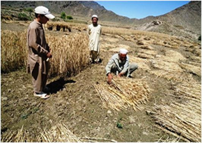
Figure 1.6 Harvesting Wheat, Khurram Chhena, Mohmand TD
Livestock Breeding; Mohmand TD
The following table shows the livestock position in Mohmand TD as per Livestock Census 2006 (qtd. in FATA Development Statistics 2013-14):
| Cattle | 232,544 Heads | Buffalos | 3,439 Heads | Sheep | 133,887 Heads |
| Goats | 378,245 Heads | Camels | 431 Heads | Horses | 221 Heads |
| Asses | 18,178 Heads | Mules | 454 Heads |
Table 1.8 Mohmand TD Livestock Statistics
Balki sheep and tirahi or afridi sheep are the indigenous livestock breeds of the TD.
Poultry Farms; Mohmand TD
Backyard poultry farming[1] is an intrinsic part of Pakistan’s rural economy. Conditions for poultry farming are particularly favourable in the upper reaches of all tribal districts, with Khyber and Kurram TDs currently home to the largest numbers of poultry farms. Around 60 commercial poultry farms[2] are operating in Mohmand TD.
Fishing; Mohmand TD
The rivers and streams[3] that traverse the land harbour a variety of fish, depending on the climatic regime. Cold waters in the upper reaches are suitable for trout, while warmer waters in the lower reaches favour carp. These aquatic resources are ideally suited for the development of fisheries.
Fishing is carried out in the streams, rivers, and lakes, but most of this fish is consumed locally.
Bee Keeping/Api Culture; Mohmand TD
Government of Pakistan is promoting the bee keeping/ honey production industry in former FATA to help create employment and to generate income.
Minerals and Mining; Mohmand TD
The mountains[4] of the tribal areas yield a variety of minerals, ranging from marble and granite to copper and gold. Since mineral extraction depends heavily on labour, the mining industry can serve as an immediate means to creating employment in the region. Considering the reserves that have already been identified, the sector has the potential to become a major employer in the long term.
The mineral resources of Mohmand TD include marble, chromate, soapstone, quartz, serpentine, and feldspar which are being commercially mined in the TD. Mineral potential includes copper, emeralds, jade, asbestos, and talc.
Industry and Manufacturing; Mohmand TD
There are no industrial zones/ estates in Mohmand TD, but there are 227 registered industrial units. Of these, 50 units are closed. The following table shows the number and type of industry in Mohmand TD (FATA Development Authority, Industries Survey Report, 2010; latest available)[5]:
| Industry | No. | Industry | No. |
| Sporting & Light Hunting Arms | 04 | Cement Blocks | 09 |
| Chips | 04 | Crush Stones | 02 |
| Flour Mills | 01 | Furniture | 01 |
| Green Chips | 01 | Ammunition | 02 |
| Lining Acid | 03 | Making Chips | 01 |
| Making Furniture | 01 | Marble Stones | 100 |
| Marble Tiles | 44 | Pots Powder | 06 |
| Powder | 38 | Scrap Steel | 01 |
| Shoes | 01 | Soap & Detergent | 04 |
| Stone Grinding | 01 | Talcum Powder | 03 |
Table 1.9 Mohmand TD Industries
Handicrafts; Mohmand TD
Household items made of marble and from the leaves of the mazri palm are the main handicrafts of the TD. The products made of the leaves of the mazri palm include caps, mats, ropes, baskets, brooms, trays, hand fans, and grain baskets. Other items include embroidery on clothes.
[1] Sustainable Development Plan 2007-15, Civil Secretariat FATA
[2] Table 17: No. of Commercial Poultry Farms in KP
[3] Sustainable Development Plan 2007-15, Civil Secretariat FATA
[4] Sustainable Development Plan 2007-15, Civil Secretariat FATA
[5] KP Development Statistics do not record ‘Industry’ data for former FATA Agencies.
Economic Infrastructure; Mohmand Tribal District
The major road of the TD is the blacktopped road branching off from the main
Shabqader-Michini Road at Pir Qila; it passes through Yekka Ghund, Ghalani, Main Mandi, and Yosef Khel. Another road connects the TD to Bajaur. The TD lacks railway and air connections.
Road Statistics; Mohmand TD
There are two types of roads in Mohmand TD: High type and Low type. The following table shows the road statistics as per KP Development Statistics 2019-20:
| High Type | 476.4 km |
| Low Type | 131.3 km |
| Total | 607.7 km |
Table 1.10 Mohmand TD Road Statistics
Important roads of the TD are:
- Pir Qila – Yousafkhel – Nawagai Road
- Krapa Pindiali – Danishkool – Ambar – Inzari Road
- Mian Mandi – Khapakh Bahai Qila Road
- Michni Militia Camp Road
- Mohmand Peripherry Blockade Road Phase I and Phase II
- Damano Killi – Bucha Road
- Mamad Gat – Chamarkand Road
Rail and Airways; Mohmand TD
There is no railway in Mohmand TD. The nearest railway station is at Zintara in Khyber TD.
There is no airport in the TD. The nearest airport is Peshawar Airport.
Radio and Television; Mohmand TD
No data available.
Telecommunications; Mohmand TD
According to KP Development Statistics 2018-19, there are 04 telephone exchanges in Mohmand TD. These exchanges provide 1,108 connections. In addition, private cellular companies provide their services in the region.
Post Offices/ Courier Services; Mohmand TD
According to KP Development Statistics 2018-19, there are 22 post offices with zero headoffice, 02 sub-post offices and 20 branch offices in Mohmand TD.
Banking/ Financial Institutions; Mohmand TD
There are a total of 02 Branches of United Bank Ltd. operating in the TD, according to the FATA Development Statistics 2008 (more recent data is not available; KP Development Statistics 2018-19 do not record data for Tribal districts).
Electricity and Gas; Mohmand TD
TAESCO (Tribal Agency Electric Supply Corporation) supplies and distributes electricity in FATA. Sarhad Hydel Development Organization (SHYDO), and Water and Power Development Authority (WAPDA) are responsible for power generation in the Province. Gas for domestic use is not available.
Educational Institutions; Mohmand TD
Total literacy rate of Mohmand TD as per the 1998 census is 11.3%. Male literacy rate is 19.1%, whereas female literacy is 1.9%. There were no schools in the TD until 1950, when the first school was opened in Subhan Dheri. The following table shows the number of government educational institutions in Mohmand TD (KP Development Statistics 2018-19):
| Institution | Boys/Girls | Institution | Boys/Girls |
| Primary Schools | 312/180 | Mosque Schools | 06 |
| Middle Schools | 38/20 | High Schools | 24/13 |
| Higher Secondary | 02/01 | Community Schools | 67 |
| Degree Colleges | 01/01 | Universities | – |
| Polytechnic Institutes | 01- | Commercial Training | 01 |
| Vocational Training Inst. | – | Private Schools | –[1] |
Table 1.12 Mohmand TD Educational Institutes: Government
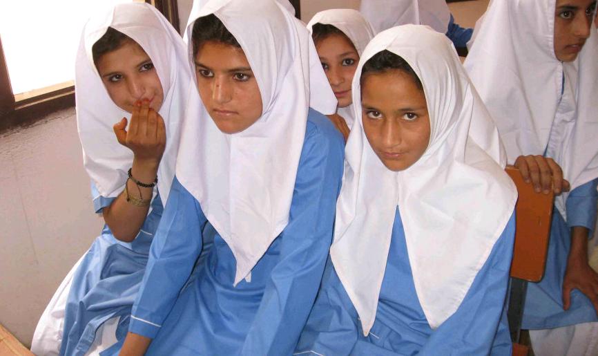
Figure 1.13 School girls in Jhanda, Mohmand TD
Healthcare Facilities; Mohmand TD
The following table shows the government Health Care Institutions in Mohmand TD as per KP Development Statistics 2018-19:
| Institution | No/Beds | Institution | No./Beds |
| Hospitals | 02/118 | Dispensaries | 19/- |
| Rural Health Centers | 03/16 | Basic Health Units | 26/- |
| Child Health Centers | -/- | Mother Child Health Centers | – |
| TB clinics | 03/- | Leprosy Clinics | NA |
Table 1.14 Mohmand TD Health Institutes
Policing; Mohmand TD
The District Police Officer (DPO) is directly responsible to the District Mayor for public safety. The Police Department is headed by the Senior Superintendent of Police (SSP). The SSP supervises and controls the police force in maintaining law and order, and investigation of cases of a criminal nature. The Police Department operates under the Police Rules. There are no Police Stations in the District.
The Levy Force, Khassadars and the Scout Troops operating in the erstwhile Mphmand Agency have been absorbed into the KP Police as per the KP Levies Force Bill 2019.
[1] KP Development Statistics 2018-19 do not record data.
Environment and Biodiversity; Mohmand Tribal district
The ambient air quality in the TD is excellent due to minimal sources of air emissions. The only source of impact on the quality of the ambient air is the rare vehicular traffic on the roads, which causes some dust emissions whose effect, is largely localized. The main pollutants from vehicle exhaust are lead, particulate matter, carbon monoxide, sulfur dioxide, and nitrogen oxides. These emissions temporarily affect the air quality in the immediate vicinity of the roads.
Flora and Fauna; Mohmand TD
Flora; Mohmand TD
The flora of the TD includes babul, kikar, phulai, vann (acacia sp), wild olives (oleo sp) and oak (quercus sp). In the areas where water is available mulberry and poplar trees are also grown. Other trees grown in the TD are mesquite (Prosopis juliflora), ber (Zizyphus sp.), jhand (Prosopis sp), gurgura (Monotheca buxifolia), and mazri/ dwarf palm (Nannorhops ritchieana). The shrubs of the TD include aak (Calotropis amiltonit), sanatha (Dodonia viscosa), red poppy (Papaver rhoeas), camel thorn (Acacia erioloba) and drab grass.
A number of medicinal herbs are also found in the TD. Some of these are dhoda (Papaver somniferum sp), nakhtar (pinus roxburghii), ispaghol (Plantago ianceolata), mushk-e-bala (valeriana jatamansi), and shandai (melia azardarach).
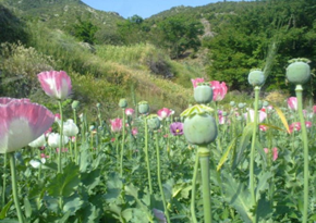
Figure 1.8 Red Poppy, Mohmand TD
Fauna; Mohmand TD
The only wildlife found in the Mohmand Tribal district includes wild boar, rabbits, and jackals. Avifauna includes chakor, see-see partridge, ducks, snipe, quails, wild goose, and sand grouse.
Protected Wildlife Areas and Endangered Wildlife; Mohmand TD
At present, there are no wildlife protected areas in the former FATA region, but the GoKP has passed a law for the creation of protected areas in the region.