Share now
Map of Khyber Pakhtunkhwa

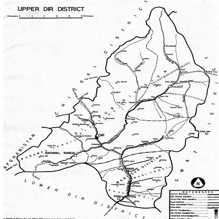
Map of Upper Dir District
Khyber Pakhtunkhwa Districts
- Peshawar District Profile
- Abbottabad District Profile
- Bannu District Profile
- Battagram District Profile
- Buner District Profile
- Charsadda District Profile
- Chitral District Profile
- Dera Ismail Khan District Profile
- Lower Dir District Profile
- Upper Dir District Profile
- Hangu District Profile
- Haripur District Profile
- Karak District Profile
- Kohat District Profile
- Kohistan District Profile
- Lakki Marwat District Profile
- Malakand District Profile
- Mansehra District Profile
- Mardan District Profile
- Nowshera District Profile
- Shangla District Profile
- Swabi District Profile
- Swat District Profile
- Tank District Profile
- Torghar District Profile
- Bajaur Tribal Distyrict Ptofile
- Khyber Tribal District Profile
- Kurram Tribal District
- Mohmand Tribal District Profile
- North Waziristan Tribal District Profile
- Orakzai Tribal District Profile
- South Waziristan Tribal District Profile
Also visit: Sindh, Punjab, Baluchistan
Introduction/Geographical Details; Upper Dir District
Upper Dir district is located in Dir Valley between 35° 04Ꞌ to 35° 46Ꞌ north latitudes and 71° 32Ꞌ to 72° 32Ꞌ east longitudes. The district is bordered by Chitral district and Afghanistan on the north and northwest, Swat district on the east, and by Lower Dir district on the south.
Upper Dir District at a Glance
| Name of District | Upper Dir District | ||
| District Headquarter | Dir Town | ||
| Population[1] | 946,421 persons | ||
| Area[2] | 3,699 km2 | ||
| Population Density[3] | 255.9 persons/ km2 | ||
| Population Growth Rate[4] | 2.64 % | ||
| Male Population[5] | 49.2% | ||
| Female Population[6] | 50.8% | ||
| Urban Population[7] | 4.7% | ||
| Tehsils/Talukas | 06 Tehsils:
1. Barawal Tehsil 2. Chapar Tehsil 3. Dir Tehsil 4. Kalkot Tehsil 5. Khal Tehsil 6. Wari Tehsil |
||
| Main Towns | Kotkay, Barawal, Karo, Nihang, Toormang, Usherai, Katiagam Wazirzada, Palam, Say, and Kalkot | ||
| Literacy Rate[8] | 42.0% | ||
| Male Literacy Rate[9] | 64.0% | ||
| Female Literacy Rate[10] | 22.0% | ||
| Major Economic Activity[11] | Agriculture with its Allied Livestock Breeding and Fishing | 65.8% | |
| Construction | 9.7% | ||
| Community, Social & Personal Services | 9.3% | ||
| Transport, Storage & Communication | 3.9% | ||
| Wholesale/Retail, Hotel/Restaurant | 7.7% | ||
| Manufacturing | 3.2% | ||
| Others | 0.5% | ||
| Main Crops | Wheat, maize, rice, sugarcane, barley, maash, masoor, moong, mustard, rapeseed & canola, cumin, and tobacco | ||
| Major Fruits | Walnut, citrus, apples, apricots, peach, pears, plums, fig, loquat, mulberry, and persimmon | ||
| Major Vegetables | Chilies, onions, potatoes, tomatoes, garlic, peas, cumin seeds (nearly all the kharif and rabi vegetables are grown in irrigated areas) | ||
| Forests (Area)[12] | 259,527 HA[13] | ||
| Total Metalled Road[14] | 259.0 km | ||
| Shingle Roads[15] | 481.8 km | ||
| No. of Grid Stations[16] | Peshawar Electric Supply Company (PESCO) looks after supply of electricity to the district. | ||
| No. of Tel. Exchanges[17] | 19 Telephone exchanges with 2,630 connections | ||
| No of Industrial Units[18] | No Industrial Estate in the district. There are 12 registered industrial units | ||
| Major Industry[19] | Cement Based | 1 Unit | |
| Flour Mills | 2 Units | ||
| Furniture | 9 Units | ||
| Household Size[20] | 8 persons per house | ||
| Houses with Piped Water Inside[21] | 18.9% | ||
| Houses with Electricity[22] | 38.5% | ||
Table 1.1 Upper Dir District at a Glance
[1] 2017 Census
[2] 1998 Census; 2017 Census uses spatial data
[3] 2017 Census
[4] 2017 Census
[5] 2017 Census
[6] 2017 Census
[7] 2017 Census
[8] Pakistan Social & Living Measurement Survey 2014-15 (PSLM); latest available
[9] PSLM
[10] PSLM
[11] 1998 Census; 2017 Census data has not been made public yet.
[12] KP Development Statistics 2018-19
[13] Land Utilization Statistics report 81,332.0 HA of forests
[14] KP Development Statistics 2013-14
[15] KP Development Statistics 2013-14
[16] KP Development Statistics 2013-14
[17] KP Development Statistics 2013-14
[18] KP Development Statistics 2013-14
[19] KP Development Statistics 2013-14
[20] 1998 Census; 2017 Census data has not been released yet.
[21] 1998 Census; 2017 Census data has not been released yet.
[22] 1998 Census; 2017 Census data has not been released yet.
Brief History of Dir Princely State – Governmental Structure – Administrative Divisions – Historical/Heritage and Tourist/Picnic Spots
Brief History of Dir Princely State; Upper Dir District
As described in the chapter on Lower Dir district, Dir was a small Princely State in Khyber Pakhtunkhwa Province. Bordering Chitral, this State was located in the valley of River Panjkora, which originates in the Hindu Kush Mountains and joins the Swat River near Chakdara. It was mainly comprised of the terrain drained by Panjkora River and its effluents. It was bordered by Swat district in the east, Bajaur agency of FATA on the west, Chitral district on the north and Malakand district (then Malakand Agency) on the south. After acceding to Pakistan in 1948, the State enjoyed relative independence and continued to be ruled by the Nawabs/Khans of Dir. It was amalgamated with Pakistan in 1960 as a Tribal Agency, and was finally merged into NWFP (now KP) as a district in 1969. Due to administrative reasons, in 1996, Dir district (of 5,282 km2 area) was divided into 2 districts: Upper Dir and Lower Dir, with Dir and Timergara as their respective headquarters.
Dir derives its name from a Sanskrit word that means “place of worship, monastery or convent where one can live in seclusion from others.” Dir takes its name from the village, Dir, which served as capital of the State during the Nawabs’ era.
Since the history of both Upper and Lower Dir districts is the same, it has been recounted in the chapter on Lower Dir district.
Governmental Structure; Upper Dir District
At the Federal level, Upper Dir district is allocated a set number of representatives in both the National Assembly and the Provincial Assembly:
- Number of seats in the National Assembly 1[1]
- Number of seats in the Provincial Assembly 4
Under the Local Government Act District Dir (Upper) has 1 District Council constituted by general seats, seats reserved for women, peasants/workers, youth, and non-Muslims as prescribed under the Khyber Pakhtunkhwa Local Government Act 2013. Upper Dir District Council is composed of 31 general members, 10 women members, 2 peasants/worker members, 2 minority members, and 2 youth members.
Administrative Units; Upper Dir district
Upper Dir district with an area of 3,699 km2 is divided into 6 Tehsils as follows:
| Barawal Tehsil | 03 Union Councils |
| Chapar Tehsil | 03 Union Councils |
| Dir Tehsil | 13 Union Councils |
| Kalkot Tehsil | 03 Union Councils |
| Khal Tehsil | 01 Union Councils |
| Wari Tehsil | 08 Union Councils |
Table 1.2 Upper Dir Administrative Units
[1] shared by Lower Dir
Historical/Heritage and Tourist/Picnic Spots; Upper Dir District
There are no protected heritage buildings in the district.
The entire district can be termed a tourist destination. The whole district is mountainous with green forests.
- Kumrat. Upper Dir: Kumrat is a scenic valley, situated at a height of 2,469 m above mean sea level. The valley offers mountaineering, trekking, and rock climbing. Other strikingly beautiful spots in Dir Kohistan valley are Thall, Lamutai, Seri, Kalkot, Jandrai, Jankai, and Pathrak
- Barawal Valley Upper Dir: This scenic place is comprised of sub-valleys: Shingara Dara, Sunai Dara, and Nasrat Dara. The whole area is the hub of wildlife with sprawling oak forests on the slopes of the mountains. Fresh apples, grapes, walnut, peaches, plums, pears, cherries, and honey are favorite locally-produced items
- Shahi Upper Dir: A major tourist spot. Located about 2,300 m above sea level, sitting atop the mountains of Samar Bagh and Barawal, the area is in full bloom during the summer season. Its plain area is nearly 1 km long, and is encircled by towering mountains of the Soorgulo Sar
- Bin Shahi Upper Dir: Located just 20-25 km from Shahi, Bin Shahi is about 2,500 m above sea level. The place, inhabited by its original Mishwani tribe, can be reached from Shahi on a sharply bending metalled road that has a sharp incline as it scales the mountains. Shalkhokas Danda, a famous lake, is located in the area. Visitors can participate in mountain climbing and trekking. Dense conifer forests are found on the mountains. The area is in proximity to the Kunar province of Afghanistan
- Khall Upper Dir: This is a beautiful village of Upper Dir. Citrus gardens and watermelon are in abundance. Malta and Zari caps are the specialties of Khal
- Proper Dir (or Dir town): This town is an ancient historical place. It is the headquarters of the district, situated on the Dir-Chitral road on the banks of Dir River. Its natural beauty attracts tourists. An important building is the residence of the ex-Nawab of Dir. There are many hotels which are equipped with modern facilities. Houses are compact and scattered on the slopes of the mountains, which gives the town a beautiful facade
Places like Skhokas, Rokhna, Shalkandi, and Samar Bagh present natural beauty as well. Distance to Shahi from Peshawar via Samar Bagh is around 234 km and via Barawal-Dir about 276 km.
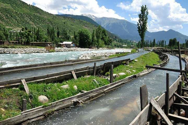
Figure 1.11 Wooden Canals in Kumrat Valley; Upper Dir
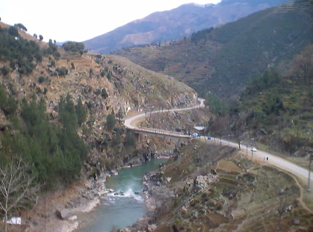
Figure 1.12 A Road from Dir to Kumrat Valley
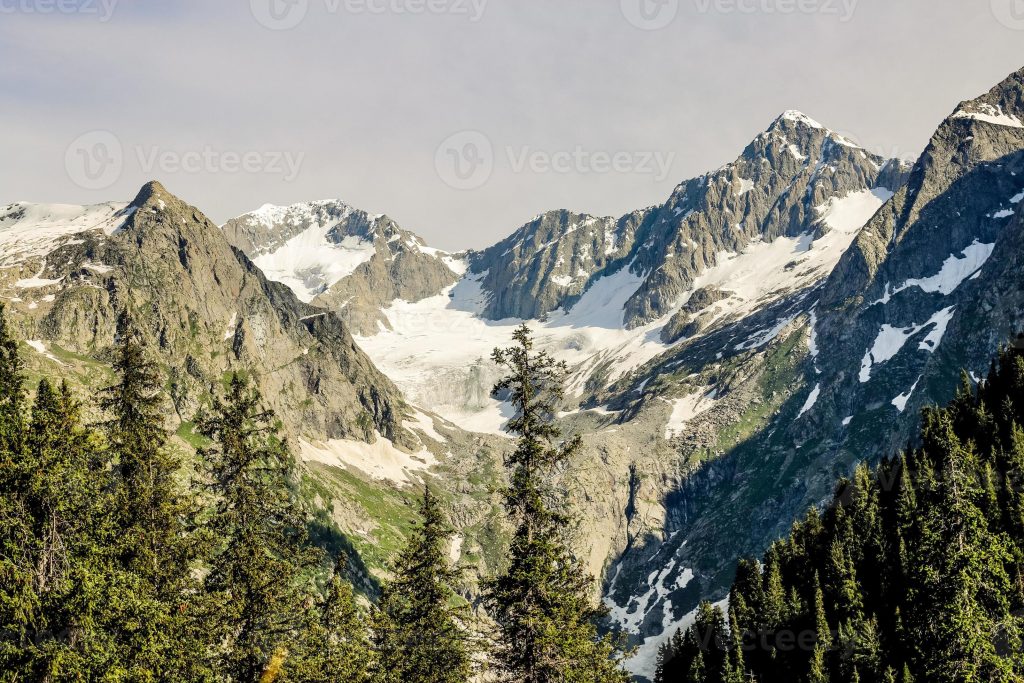
Figure 1.13 Kumrat Valley
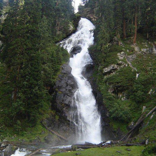
Figure 1.14 A Small Waterfall in Dir
Topography of Upper Dir district
The entire area—both Upper and Lower Dir districts—is in the Panjkora valley and is drained by the River Panjkora. The upper portion of the Panjkora valley called Panjkora Kohistan or Kohistan-e-Malizai now forms Upper Dir district. Toormang, Ushairi, Nehag, Sultan Khail, Kumrat, Karo, Barawal, Lawari, and Kohistan valleys are the valleys in Upper Dir district.
The topography of the district is dominated by high mountains. The most important mountain range is the Hindu Raj. It runs from northeast to southwest along the northern borders with Chitral district. The Lowari Pass or Lowari Top, with a height of 4,189 m above sea level, is located in this range. The highest peak at the extreme north of the district is about 6,000 m above mean sea level. The height decreases slowly towards the southwest, along the River Panjkora, to less than 2,000 m.[1]
In winter, the whole area remains snow-covered. The mountains in the western part of the district are covered with forests, while the eastern mountain range, Dir Kohistan, is barren.
Some of the important mountain peaks are Balakot Sar (2,096 m), and Lowari Top (4,189 m). The highest peak at 6,000 m is un-named.
Some of the more beautiful valleys of the district include Ushairy Valley, Kumrat Valley, and Nehag Valley.
Mountain Passes; Upper Dir district
Lowari Pass is the most important pass, which connects Chitral with Dir. The town of Dir lies at the foot of the Lowari Pass.
Malakand Pass connects Swat, Dir, and Malakand.
Rivers, Lakes, and Streams; Upper Dir district
The main river of the district is Panjkora River (a tributary of River Swat). This river derives its name from its 5 tributaries: Gawaldai Khwar, Kumrat Khwar, Jhandrai Khwar, Biar Khwar, and Dogdarra Khwar. River Panjkora originates from Dir Kohistan, and is also known as River Dir. Other tributaries of River Panjkora flowing through the district include Rishkun Khwar, Kurmai Khwar, Shilkai Khwar, Junkai Khwar, Shahur Khwar, and Shiringal Khwar.
In addition to the above, a large number of streams, most of which are glacier-fed and hence intermittent, also join River Panjkora at various places.
Saidgai Danda or Sidgai Lake lies in the Hindu Kush chain of mountains. Katora Lake, a glacial melt lake (Katora means a bowl) is located in Kumrat Valley. Several small and large lakes are scattered in the immediate vicinity of Saidgai Danda. Some other lakes of the district include Kashora Dhand, Karth Banda, and Parhlo Banda.
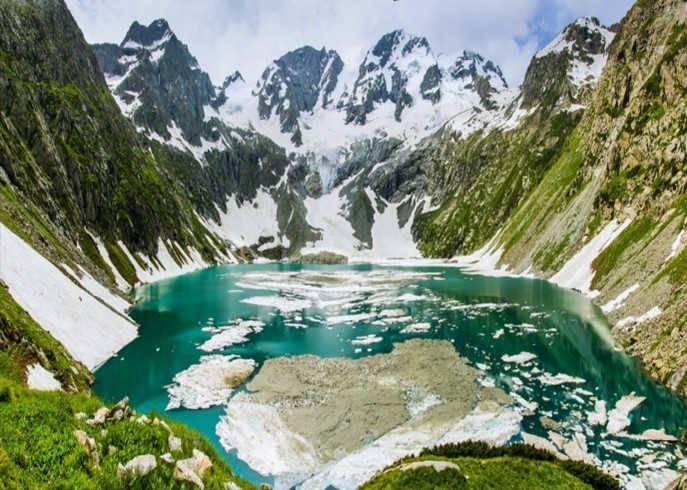
Figure 1.3 Katora Lake
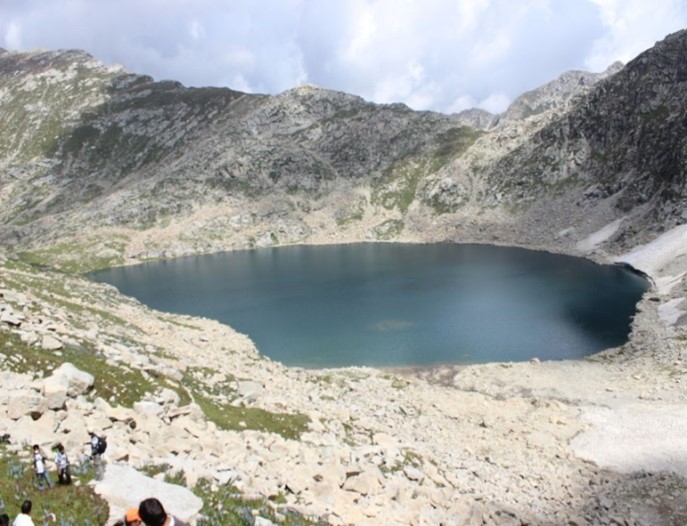
Figure 1.4 Saidgai Danda Lake
Forests; Upper Dir district
The forests of Upper Dir are Dry Temperate Mixed Coniferous type, with deodar (Cedrus deodara), kail or blue pine (Pinus wallichiana), chilghoza (Pinus geradiana), spruce (Picea smithiana), oak (Quercus sp.), olea, and pistacia as the main species. Sub-Alpine and Alpine Scrub comprising kail or blue pine (Pinus wallichiana) and Abies, Betula, and Salix species are also found. The following table shows the type of forests and their area as per KP Development Statistics 2018-19:
| Total Forest Area | 641,306 A | Resumed Land | – A |
| Reserved Forests | – A | Communal Forests | 107,714 A |
| Protected Forests | 277,311 A | Guzara Forests | – A |
| Unclassed Forests | – A | Private Plantation | 35,351 A |
| Miscellaneous | 220,930 A | Linear Plantation | – km |
Table 1.3 Upper Dir Forests
Nearly all the valleys, like the Usherai Valley, are well-forested with both dense and open forests.
Figure 1.5 A Wooden Bridge, River Panjkora, Upper Dir
Soils; Upper Dir district
The soils of the district developed from materials derived from local weathering of bed rocks (residuum and colluviums) due to active erosion of the land surface by water.
The soils are shallow, slightly gravely loams/slit loams. Dir is underlain by metamorphic and igneous rocks.
On gentle slopes, the soil is deep and rich due to an abundance of organic matter.
Climate; Upper Dir district
The district has a humid sub-tropical climate. The summer season is moderate and warm. June, July, and August are hot months. The mean maximum and minimum temperature during the month of June is about 33 °C and 16 °C respectively. During the spring season, the wind storms from Lowari Top (locally known as Badama), occur in the afternoons which make the nights chilly and intolerable. The winter season is cold and severe. Temperature rapidly falls starting in November. December, January, and February are very cold months. During this period temperature generally falls below freezing point. The mean maximum and minimum temperature during the month of January is 11 °C and -2 °C respectively.
The rains are received from frontal cyclones from the west and their passage, as well as from the penetrative Monsoons periods. The rains are usually accompanied by heavy thunderstorms. The winter rainfall is more than that received in the summer season. The maximum winter precipitation has been recorded during the month of March, which is about 242 mm. The relative humidity is quite high throughout the year. Mean average annual rainfall in the district is about 1,420 mm.
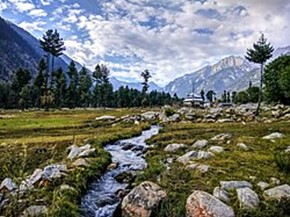
Figure 1.7 Kumrat Valley (Upper Dir) in Summer
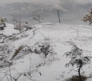
Figure 1.8 Dir District during Winter
Seismic Activity; Upper Dir district
The district belongs to Zone 3 of the Seismic Zone Map of Pakistan, which means moderate to severe damage due to earthquakes.
[1] 1998 District profile by Govt of Pakistan; Upper Dir
Population of Upper Dir District
The following table shows the Tehsil-wise population of Upper Dir district as per the 2017 Census:
| District | Area
km2 |
Population | Male % | Female% | Urban
% |
Growth Rate % |
| Upper Dir District | 3,699 | 946,421 | 49.2 | 50.8 | 4.7 | 2.64 |
| Dir Sub-Division | 3,050 | 624,614 | ||||
| Wari Sub-Division | 649 | 321,807 |
Table 1.4 Upper Dir Population Statistics
In 1996, when Upper Dir district was created, it had 2 sub-divisions instead of Tehsils. It was divided into 6 Tehsils a few years later, and data on the population of these Tehsils is, thus, not available.
Religions; Upper Dir district[1]
| Muslims | 99.8% |
| Christians | Negligible % |
| Hindus | Negligible % |
| Ahmadis | Negligible % |
| Scheduled Castes | Negligible % |
| Others | Negligible % |
Table 1.5 Upper Dir Religions
Languages; Upper Dir district[2]
| Urdu | 0.1% |
| Punjabi | Negligible % |
| Sindhi | Negligible % |
| Pushto | 92.5% |
| Balochi | Negligible % |
| Seraiki | 0.1% |
| Others | 7.3% |
Table 1.6 Upper Dir Languages
Hindko, Gujri and Khowar languages are spoken and understood in the district and are included in “Other” languages of the district.
[1] 1998 Census; 2017 Census data has not been made public yet.
[2] 1998 Census; 2017 Census data has not been made public yet.
Economic Activity – Economic Infrastructure
Economic Activity; Upper Dir District
Farming, daily wages, trade, and working overseas are the main occupations of the people in Upper Dir. The district is mostly mountainous terrain. Agricultural land is available only on the hill slopes and in the valleys, and as such, mechanized agriculture is hardly done except in those areas that are easily accessible for transportation of agricultural machinery. Farming is usually carried out with crude implements like ploughs drawn by bullocks (the traditional method of ploughing). Agriculture mostly depends on rainfall.
The following are the main economic activities of the district:
- Agriculture with its allied Livestock Breeding & Fishing (65.8%)
- Construction (9.7%)
- Community, Social & Personal Services (9.3%)
- Transport, Storage & Communication (3.9%)
- Wholesale/Retail, & Hotel/ Restaurant (7.7%)
- Manufacturing (3.2%)
- Others (0.5%)
Land Use; Upper Dir district
The following table shows the main land use statistics of Upper Dir district as per KP Development Statistics 2018-19:
| Total Area | 369,900 HA | Reported Area | 126,500 HA |
| Total Cultivated Area | 31,572 HA | Net Sown | 28,350 HA |
| Current Fallow | 3,222 HA | Uncultivated Area | 94,928 HA |
| Culturable Waste | 6,177 HA | Forest Area | 81,332 HA |
Table 1.7 Upper Dir Land Use Statistics
Irrigation Network; Upper Dir district
The district is mostly irrigated by River Panjkora and its tributaries. Small irrigation channels (mostly community-owned) have been dug to bring water from these rivers and streams to the agricultural lands. The District Councils and private individuals are trying to improve irrigation by developing irrigation schemes; these are the Irrigation Scheme Gundigar and Irrigation Scheme Darora.
The following table shows the mode and area irrigated by each mode in the district as per KP Development Statistics 2018-19:
| Total Irrigated Area | 22,391 HA | Govt. Canal Irrigated | 19,645 HA |
| Tube Wells | 91 HA | Wells | 94 HA |
| Tanks | 234 HA | Private Canal Irrigated | 1,236 HA |
| Others | 1,003 HA | Lift Pumps | 88 HA |
Table 1.11 Upper Dir Irrigation Statistics
Agriculture; Upper Dir district
Most of the Upper Dir district is mountainous terrain. Agricultural land is available only on the hill slopes and in the valleys. The Upper Dir district belongs to the Northern Dry Mountains Agro-Ecological Zone of Pakistan. This area is mostly irrigated by glacier-fed streams and rivers. Poppy cultivation was once very popular, but since its ban, people are supported to grow other crops.
Wheat, maize, rice, sugarcane, barley, maash, masoor, moong, mustard, rapeseed & canola, and tobacco are some of the crops grown in the area.
Walnut, citrus, guava, apples, apricots, peach, pears, plums, fig, loquat, mulberry, and persimmon are some of the fruits grown in the area.
Chilies, onions, potatoes, tomatoes, garlic, peas, and cumin seeds, as well as nearly all the kharif and rabi vegetables are grown in irrigated areas, but the production is just enough to meet the local demand.
Livestock Breeding; Upper Dir district
The following table shows the statistics of livestock in Upper Dir district (2006 Census of Livestock) as quoted in KP Development Statistics 2018-19:
| Cattle | 232,013 Heads | Buffaloes | 4,964 Heads |
| Sheep | 91,229 Heads | Goats | 3,525,488 Heads |
| Camels | 237 Heads | Horses | 640 Heads |
| Asses | 4,311 Heads | Mules | 2,919 Heads |
Table 1.8 Upper Dir Livestock Statistics
Dhanni breed of cattle is common, as well as local breeds of goats known as pahari/jattal goats, teddy, and Beatle breeds of goat in low elevations of Upper Dir. Non-descriptive local breeds of sheep are also common in the district.
Poultry Farms; Upper Dir District
The total number of poultry birds according to Khyber Pakhtunkhwa Development Statistics 2018-19 is 713,500 birds (2006 Census).
Fishing; Upper Dir district
Fishing is not a trade commodity, and any fish caught in the rivers/streams is consumed locally. Trout fishing is carried out as a sport by tourists, mostly available in the Kumrat Valley area. In order to promote Trout Fishing, the Government of KP has developed a Fish Hatchery for trout in the district.
Bee Keeping/Api Culture; Upper Dir district
Honey is an important non-wood forest production of Khyber Pakhtunkhwa. There are many types of honey being produced in Khyber Pakhtunkhwa but Sedar (ber in Urdu) and acacia modesta (Phulai in Urdu) honey are produced in the highest quantities. The total number of the bee keeper entrepreneurs (farm) in Khyber Pakhtunkhwa is about 3,800 and the direct employment in these farms is of 17,500 people.[1]
Mining; Upper Dir district
Commercial mining is not carried out in the district. According to District Census Report 1998, Sarhad Development Authority has explored and discovered the presence of copper in the localities around Bekaray, Alai, Guma Dand, and Barawal but the occurrence is too small to be exploited commercially. Another known mineral present in the district is iron ore. There is no exploration for oil and gas in the district.
Industry and Manufacturing; Upper Dir district
There is no industrial estate in the district, but there are a total of 12 industries. The following table shows the type of industry and number of units in the district (KP Development Statistics 2018-19):
| Industry | Number | Industry | No. of Units |
| Cement Based | 01 | Flour Mills | 02 |
| Furniture | 09 |
Table 1.9 Upper Dir Industries
Trade (Import/esport); Upper Dir district
The district trades in food grains, walnuts, peas, potatoes, and furniture. The agricultural produce like food grains, peas, and potatoes are exported to other parts of Pakistan also.
Handicrafts; Upper Dir district
Handicrafts include zari embroidered caps, waistcoats, women’s clothes, and shawls. Other handicrafts include knives. Other famous handicrafts include lamsi (a carpet made of wool of local animals) and palace (the leather of animals dried and cleared for prayers). Women make local baskets fashioned from ghawarija (a small herbal plant with elastic straws used for basket making), parwata (a creeping plant with weak roots and serving as food for animals) and berang (an oak like evergreen tree whose leaves are used as fodder). Hamlets, caps and tandoor (bread oven) are also famous handicrafts made by local women.
Economic Infrastructure; Upper Dir District
District headquarter of Upper Dir is connected with metalled or shingled roads to all Tehsil headquarters. The National Highway N-45 passes through the district, and connects it to Nowshera, and from there to other parts of Pakistan. The district is mountainous so there is no railway or airport.
Road Statistics; Upper Dir district
The district headquarters of Upper Dir is connected with metalled or shingled roads to all Tehsil headquarters. The following table shows the road statistics as per KP Development Statistics 2018-19:
| Total Roads | 740.8 km |
| High Type Roads | 258.99 km |
| Low Type Roads | 481.76 km |
Table 1.10 Upper Dir Road Statistics
Some of the important roads of the district include:
- Dir-Lowari Pass
- Dir-Patrak
- Dir-Shahi
- Dir-Malakand Road (also called National Highway N-45)
Rail and Airways; Upper Dir district
There are no railway stations or airport in the district. The nearest airport is the Chitral Airport.
Radio and Television; Upper Dir district
There is no state-owned or private radio or television station in the district. But both can be accessed through a fiber optic network.
Telecommunications; Upper Dir district
According to KP Development Statistics 2018-19, there are 19 telephone exchanges with 2,630 connections. Cellular phone service is also available in the district.
Post Offices; Upper Dir district
There are 20 offices of Pakistan Post in the district without a head office but 5 sub-offices and 15 branch offices in the district (KP Development Statistics 2018-19).
Electricity and Gas; Upper Dir district
PESCO is responsible for providing electricity to all civil districts of KP, including Upper Dir district.
[1] Small Medium Enterprise Development Authority, Honey Processing & Packaging Common Facility Center – Mingora Swat
Banking/ Financial Services; Upper Dir district
In all, there are 24 branches of various banks in the district (KP Development Statistics 2018-19).
According to the List of Reporting Bank Branches 2019, by State Bank of Pakistan, the following banks all have branches in the district:
- Allied Bank Ltd.
- Habib Bank Ltd.
- Muslim Commercial Bank Ltd.
- National Bank of Pakistan Ltd.
- United Bank Ltd.
- Zarai Tarqiati Bank Ltd.
In all there are 17 branches of different conventional banks and 07 branches of various Islamic banks in the District.
Educational Institutions; Upper Dir district
The following table shows the number of educational institutions in Upper Dir district as per KP Development Statistics 2018-19:
| Institution | Boys/Girls | Institution | Boys/Girls |
| Primary Schools | 511/224 | Middle Schools | 61/29 |
| High Schools | 41/15 | Higher Secondary Schools | 14/04 |
| Mosque Schools | 83 | Degree Colleges | 02/01 |
| Post Graduate College | – | Polytechnic Institutes | 04 |
| Vocational Centers | – | Commerce Colleges/Institutes | 01 |
| Private Primary Schools | 113 | Private Schools (Middle to Higher Secondary) | 28 |
| Medical Colleges | – | Engineering Colleges | – |
| Universities[1] | 01 |
Table 1.12 Upper Dir Education Statistics
Healthcare Facilities; Upper Dir district
The District Health Officer Upper Dir is overall in-charge of all healthcare activities in the district. The following table shows the number of health care facilities in Upper Dir district as per KP Development Statistics 2018-19:
| Institution | No./beds | Institution | No./beds |
| Hospitals | 05/486 | Dispensaries | 11/- |
| Rural Health Centers | 03/60 | Basic Health Units | 31/- |
| Mother Child Health Centers | 01/- | Sub-Health Centers | 02/- |
| Leprosy Clinic | 03/- | TB Clinics | 01/- |
| Private Medical Practitioners | 19 | Private Hospitals[2] | 11/73 |
Table 1.13 Upper Dir Health
Policing; Upper Dir district
There are 10 police stations[3] in the district.
The District Police Officer (DPO) is directly responsible to the Zila Nazim for public safety. The Police Department is headed by the Senior Superintendent of Police (SSP). The SSP supervises and controls the police force in maintaining law and order and investigation of cases of criminal nature. The Police Department operates under the Police Rules. The Deputy Inspector General of Police is in-charge of Malakand Circle which includes Swat, Lower Dir, Upper Dir, Buner, Shangla, and Chitral. The DPO is in-charge of Upper Dir district. Upper Dir district is sub-divided into 3 police circles, each with their own police stations. Each police sub-division is headed by Superintendent Police (SP). The sub-divisions are further divided into police stations each headed by a Deputy Superintendent Police (DSP).
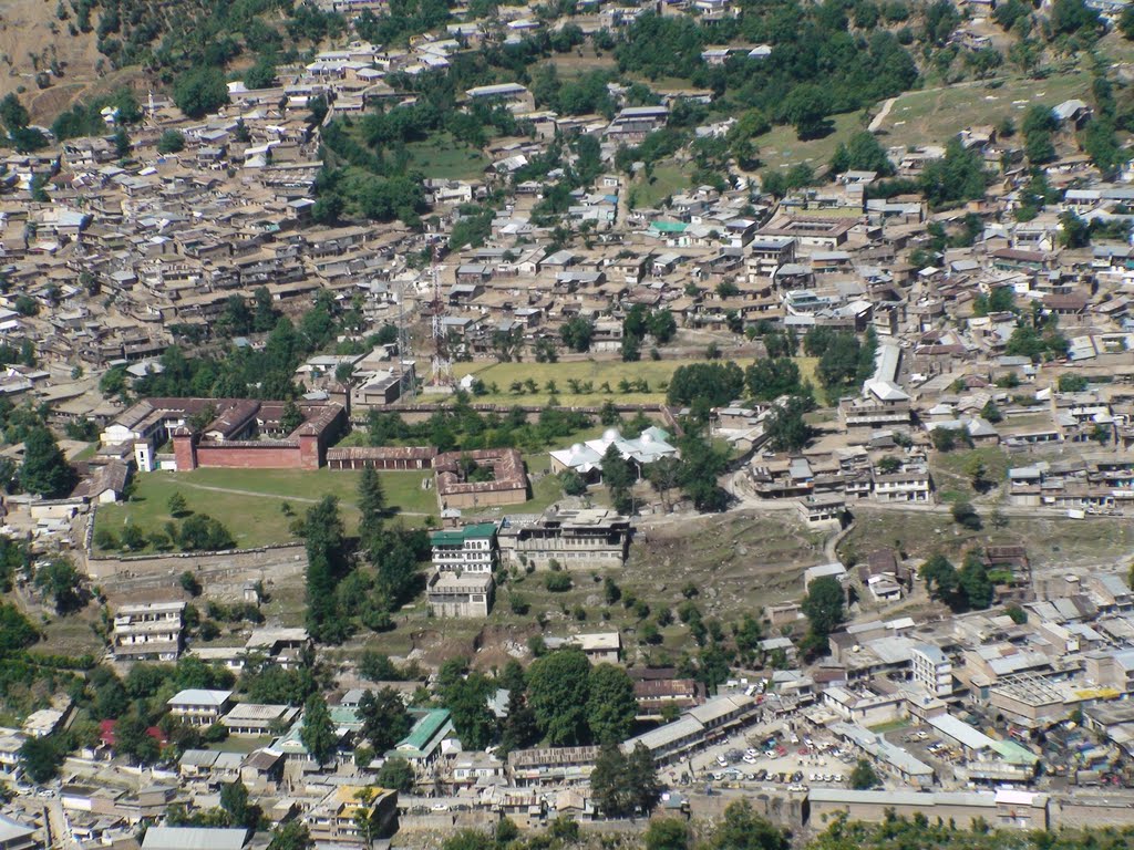
Figure 1.15 General view of Dir City
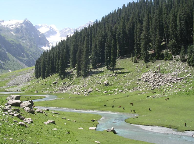
Figure 1.16 Kumrat Valley
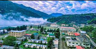
Figure 1.17 Shaheed Benazir Bhutto University Sheringal Valley
[1] Shaheed Benazir Bhutto University, Shringal
[2] Official Website of KP Province
[3] KP Development Statistics 2018-19
Environment and Biodiversity; Upper Dir District
Upper Dir district is a relatively less developed district of Pakistan and is snow-clad during winter. The mountains in the western part of the district are covered with forests, while the eastern mountain range, Dir Kohistan is barren. The air quality is good and generally, the district has a clean environment.
Flora and Fauna; Upper Dir district
Flora; Upper Dir district
The district has various types of forests each with its own flora as follows:
- Mixed forests of fir and spruce: These forests are mostly confined to the extreme remote corners of the watersheds upstream of the valley and are heavily grazed by nomadic herds of animals during summer. Oak (Quercus), walnut (Juglan), poplar (Populus), maple (Acer) and horse chestnut (Aesculus) species form the underwood in favorable locations. Barberry or rasaut (Berberis), true indigo (Indigofera) and black haw (Vibernum) are the undergrowth species
- Mixed forests of fir, spruce, pines, deodar and broad-leaved species: These forests are comprised of varying mixtures of coniferous trees, fir, spruce, blue pine, and deodar. The forests also have a varying intermixture of evergreen and deciduous broad-leaved species. In these forests, the principle species is fir, which is mixed with spruce and scattered pine while sporadic trees of yew (Taxus baccata) are also found in the forests. Other broad-leaved species associates are walnut (Juglans regia), bird cherry (Prunus padus), maple (Acer spp.) and poplar (Populus ciliata). The undergrowth consists of black haw (Vibernum spp), and indigo (Indigofera). The ground flora consists of grasses, herbs, and ferns
- Pure kail forests: The crop consists of almost pure kail species. Other coniferous species are deodar, fir, spruce, and yew in the upper parts with chir at lower levels. The broad-leaved species consist of oak (Quercus), walnut (Juglan), persimmon (Diospyros), Himalayan yew or horse chestnut (Aesculus) and some trees like chinar (Platanus) and west Himalayan alder (Alnus) are also found along streams. The under growth is composed of barberry (Berberis), indigo (Indigofera) and other associated species
- Oak, scrub forests: Thorny bushes such as barberry (Berberis), rose (Rosa), and Himalayan raspberry (Rubus) species are found in the forest type as undergrowth
- Alpine pastures: The common species in the alpine zone are common knot grass (Polygonum), locoweed (Oxytropis) and silverweed (Potentilla)
There are a large number of medicinal plants, some of which are native and others that are exotic found in the district. A total 40 species, belonging to 25 families of wild herbs, shrubs, and trees are used for the cure of various diseases.[1] Some of these are: datura (Datura innoxia Mill), dewana bhang (Hyoscyamus niger L.), puthkanda/chaff flower (Achyranthes aspera), zergul /marigold (Calendula arvensis Linn.), jangli saro/shepherd’s purse (Capsella bursa-pastoris), palpolak (Polygonum glabrum L.), woudi gwalae/Himalayan columbine (Aquilegia pubiflora), da kono zeal/jadwar (Delphinium denudatum), and wanly/wild mint (Mentha longifolia L).
A large number of flowering plants also occur in the valley, some of which are tulips, daffodils, roses, and cumin.
Fauna; Upper Dir district
Bears, both brown and black, leopard, snow leopard, Himalayan ibex, grey langur, monkeys, jungle cat, barking deer, wolf, urial, blue sheep, yellow-throated martin, red fox, pika, golden marmot, Himalayan lynx, Marco Polo sheep, marmots, goral, species of flying squirrel, Tibetian wild ass, various species of rodents, jackals, hares, porcupine, and hyenas are the common fauna of the district.
Avifauna of the district include Himalayan monal pheasant, Himalayan snow cock, snow partridge, chakor, mayna, various varieties of duck, pigeons, sparrow, black and grey partridges, koklas pheasant, monal pheasant, western-horned tragopan, hawks, and eagles are some of the key bird species found in Upper Dir. Freshwater Eurasian otters are also present in the district, though they are now very rare.
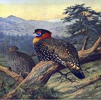
Figure 1.9 Western-Horned Tragopan
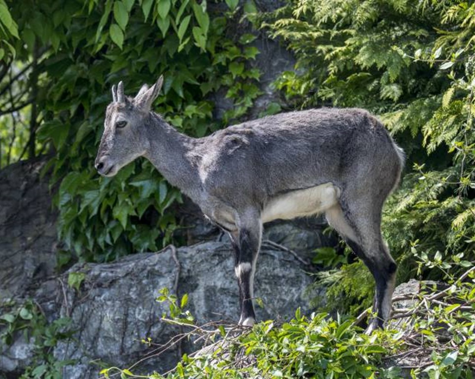
Figure 1.10 Himalayan Blue sheep
Protected Wildlife Areas and Endangered Fauna; Upper Dir district
There are no protected wildlife areas in Upper Dir district, but the western-horned tragopan (considered to be extinct in Pakistan but now re-emerged), monal pheasant, koklas pheasant, chakor, snow partridges, Himalayan snow cock, Marco Polo sheep, Himalayan blue sheep, Eurasian otters, ibex, black and brown bears, snow leopard, langur, monkeys, barking deer, and yellow-throated martin are all considered endangered and are provided sanctuary in the protected forests of the district.
[1] Ethnobotanical Study of Some Elite Plants Belonging to Dir, Kohistan Valley, Khyber Pakhtunkhwa, Pakistan By Ali Hazrat, Mohammad Nisar, Jehandar Shah, and Shujaat Ahmad