Share now
Map of Punjab

Map of Chiniot District

Punjab Districts
- Islamabad Capital Territory Profile
- Lahore District Profile
- Attock District Profile
- Bahawalnagar District Profile
- Bahawalpur District Profile
- Bhakkar District Profile
- Chakwal District Profile
- Chiniot District Profile
- Dera Ghazi Khan District Profile
- Faisalabad District Profile
- Gujranwala District Profile
- Gujrat District Profile
- Hafizabad District Profile
- Jhang District Profile
- Jhelum District Profile
- Kasur District Profile
- Khanewal District Profile
- Khushab District Profile
- Layyah District Profile
- Lodhran District Profile
- Mandi Bahauddin District Profile
- Mianwali District Profile
- Multan District Profile
- Muzaffargarh District Profile
- Narowal District Profile
- Nankana Sahib District Profile
- Okara District Profile
- Pakpattan District Profile
- Rahimyar Khan District Profile
- Rajanpur District Profile
- Rawalpindi District Profile
- Sahiwal District Profile
- Sargodha District Profile
- SheikhupuraDistrict Profile
- Sialkot District Profile
- Toba Tek Singh District Profile
- Vehari District Profile
Also visit: Sindh, Balochistan, Khyber Pakhtunkhwa
Chiniot District Profile
Introduction/Geographical Details
Chiniot district became the 36th district of the Punjab Province of Pakistan in February 2009. Before 2009, it was a tehsil of Jhang district. Chiniot district is located between 31° 23Ꞌ and 32° 4Ꞌ north latitudes, and 72° 24Ꞌ to 73° 14Ꞌ east longitudes. The district touches Faisalabad district on the east, Hafizabad district on the north, Jhang district on the south, and Sargodha district on the west.
Chiniot District at a Glance
| Name of District | Chiniot District | ||
| District Headquarter | Chiniot City | ||
| Population[1] | 1,369,740 persons | ||
| Area[2] | 2,643 km2 | ||
| Population Density[3] | 524.9 persons/ km2 | ||
| Population Growth Rate[4] | 1.86% | ||
| Male Population[5] | 51.1% | ||
| Female Population[6] | 48.9% | ||
| Urban Population[7] | 30.8% | ||
| Tehsils |
03 Tehsils: 1. Chiniot Tehsil 2. Bhawana Tehsil 3. Lalian Tehsil |
||
| Main Towns | Chiniot, Lalian, Bhawana city, Hussainabad or Nalka Adda, Satellite Town, Mehdiabad, Aliabad, Thatta Masta or Gatti Kamoka, Samanduri City, and Rabwah or Chenabnagar. | ||
| Literacy Rate[8] | 50% | ||
| Male Literacy Rate[9] | 62% | ||
| Female Literacy Rate[10] | 36% | ||
| Major Economic Activity[11] | Agriculture with its allied Livestock Breeding, Fishing | 44.4% | |
| Construction | 33.5% | ||
| Community, Social & Personal Services | 8.3% | ||
| Wholesale/ Retail, Hotel/ Restaurant | 5.7% | ||
| Manufacturing | 3.5% | ||
| Transport, Storage & Communication | 2.0% | ||
| Others | 2.6% | ||
| Main Crops | Sugarcane, wheat, rice, barley, tobacco, cotton, maize, bajra (millet), jowar (sorghum), gram, groundnut, guarseed, sunn hemp, gram, moong, maash, masoor, other pulses, rapeseed & mustard, ground nut, sesanum, linseed, sunflower and fodder | ||
| Major Fruits | Citrus, mango, banana, guava, pomegranate, and dates | ||
| Major Vegetables | Peas, onion, garlic, chilies, coriander, potato, tomatoes, turnip, cauliflower, okra, carrots, bottle gourd, brinjal, and spinach | ||
| Forests (Area)[12] | 1,000 HA[13] | ||
| Total Black Topped Road[14] | 1327.2 km | ||
| National Highways[15] | – km | ||
| Motorways[16] | – km | ||
| Provincial Roads[17] | 1327.2 km | ||
| Sugar Cess Roads[18] | – km | ||
| No Of Grid Stations[19] | Faisalabad Electric Supply Company (FESCO) supplies electricity to Chiniot district. There are 05 Grid stations, ranging in capacity from 66 KV to 132 KV | ||
| No. Of Tel. Exchanges[20] | 17 telephone exchanges, ranging in capacity from 206 lines to 7,992 lines. | ||
| Industrial Zones[21] | At present, there is no industrial estate in the district, but 92 Small, Medium, and Large enterprises are operating | ||
| Major Industry[22] | Rice Mills | 52 units | |
| Cold Storage | 10 units | ||
| Chip and Straw Board | 6 units | ||
| Electrical Goods | 1 unit | ||
| Flour Mills | 2 units | ||
| Foundry Products | 9 units | ||
| PVC Pipes | 1 unit | ||
| Sugar | 3 units | ||
| Textile Spinning | 6 units | ||
| Textile Composite | 1 unit | ||
| Ghee/ Vegetable Oil | 1 unit | ||
| Household Size[23] | 6.6 persons | ||
| Houses with Piped Water Inside[24] | 9.6% | ||
| Houses with Electricity[25] | 48.8% | ||
Table 1.1 Chiniot District at a Glance
[1] 2017 Census
[2] 1998 Census
[3] 2017 Census
[4] 2017 Census
[5] 2017 Census
[6] 2017 Census
[7] 2017 Census
[8] Pakistan Social & Living Measurement Survey 2014-15 (PSLM); Latest available.
[9] PSLM
[10] PSLM
[11] 1998 Census; all statistics are the same as Jhang district; 2017 Census data has not been made public yet.
[12] Punjab Development Statistics 2018-19
[13] Land Utilization Statistics documents 0 HA area under forests.
[14] Punjab Development Statistics 2018-19
[15] Punjab Development Statistics 2018-19
[16] Punjab Development Statistics 2018-19
[17] Punjab Development Statistics 2018-19
[18] Punjab Development Statistics 2018-19
[19] Pre-investment Study Chiniot District 2012; Latest available.
[20] Pre-investment Study Chiniot District 2012; Latest available.
[21] Pre-investment Study Chiniot District 2012; Latest available.
[22] Pre-investment Study Chiniot District 2012; Latest available.
[23] 1998 Census; same as Jhang district; 2017 Census data has not been made public yet.
[24] 1998 Census; same as Jhang district; 2017 Census data has not been made public yet.
[25] 1998 Census; same as Jhang district; 2017 Census data has not been made public yet.
Brief History – Governmental Structure – Administrative Divisions – Heritage Sites and Tourist Attractions
Brief History of Chiniot District
Chiniot district is one of the most recently created administrative units of Punjab. Formerly, it was a tehsil of Jhang district. The district is named after its headquarter town, Chiniot.
Chiniot’s name consists of two Punjabi words: chan (moon) and ote (behind). Put together, the words translate to “behind the moon.” According to the official website of District Police Office Rahim Yar Khan, Chiniot as a city existed even in pre-historic times. The history by Al Beroni entitled Tarikh Al Hind (The History of Hind) records the name “Chani Vet” for a town in this region; Al Beroni writes that “in Chani Vet, Ajhan was a famous school for Hindus where special arrangements for religious studies was [sic] made.”
At the time of Independence and till 2009, when it was upgraded to a district level, Chiniot was part of Jhang district as one of its tehsils. Thus, the district shares much of its history with Jhang district.[1]:
According to the Imperial Gazetteer of India:
Chiniot town is a very old one and is perhaps to be identified with Sakala, the capital of the White Huns which was visited by Hiuen-Tsang. It suffered much during the Durrani inroads over the last half of the 18th century, and also during the conflicts of 1848, being the scene of constant sanguinary struggles between the leaders of local factions. It now bears a prosperous aspect, most of the houses being of excellent brickwork, lofty and commodious especially those of Khoja traders who had large dealings with Amritsar, Calcutta, Bombay, and Karachi. It boasts a handsome mosque built by Nawab Saad Ullah Khan Tahim, Governor of the town under Shahjahan (Mughal Emperor); also a shrine dedicated to Shah Burhan, a Muslim saint revered by Hindus and Muslims alike. (v. 10, p. 285)
Chiniot town was considered to be among the more important cities on the trade route from Khyber Pass to Delhi. The area was part of the Mauryan Empire which was ruled by Chandragupta Maurya. Alexander the Great, who entered the subcontinent through the Khyber Pass, conquered many parts of the Mauryan Empire, including the areas of Chiniot. He himself did not enter the town of Chiniot but his troops camped here. The area remained a part of Alexander’s Greek Empire for only 2 years, after which time, Chandragupta Maurya regained his power and made the city a part of his empire again. According to some local legends, during Mauryan rule, a man called Chenek (the chief of his tribe) belonging to Chiniot became a minister in the court of Chandragupta Maurya. He helped develop the city, and constructed many schools and temples in the town.
The Mauryan Dynasty controlled the area making it a part of the Gandhara Civilization from 317 BC to 185 BC. After King Ashoka’s death (232 BC), the empire started shrinking, and small independent empires emerged. The area then came under the Indo-Greek Kingdom (Bactrian Empire; 155-130 BC).
In 471 AD, the White Huns (an Iranian nomadic tribe) took over most of Punjab. The White Huns appointed Viceroys to rule Gandhara and other conquered regions. Numerous coins minted during their rule have been discovered in Chiniot and Shahkot (Gujranwala district). The area later became part of various ruling dynasties, until, in 632 AD, it was taken over by the Chhachh Dynasty. In 712 AD, the Chhachh Dynasty under Raja Dahir was defeated by the Muslim Army led by Muhammad bin Qasim. Since then, Chiniot, like other parts of India, remained under all the Muslim Empires, like the Ghaznavids (977-1186 AD), Ghorids (897-1219 AD), the Slave Dynasty (1206-1290 AD), Khiljis (1290-1500 AD), Zaheer ud Din Babar (Mughal Emperor; 1528-1540 AD), Sher Shah Suri (1540-1545 AD) and the Mughal Empire (1605 -1857 AD).[2]
During the Khilji Rule in 1430, the Khokar family was made ruler of the Chiniot area. The Khokars were replaced by the Langa tribe of Multan, who ruled this area till 1528. This tribe was defeated by the Mughals (Zaheer ud Din Babar) who ruled Chiniot till 1540. Mogul Emperor Babar described Chiniot at many places in his book Tuzk-e-Babri. Sher Shah Suri defeated Humayun (Babar’s son) and ruled over Chiniot as well as the rest of the Indian subcontinent. Sher Shah Suri was defeated by Humayun’s son, Akbar the Great in 1556 and thus, Chiniot came under direct rule of the Mughals and remained as such till the War of Independence in 1857, during which the Mughal Empire, which was being ruled by Bahadur Shah Zafar, was completely defeated by the British, and India became a part of the British Empire.
During the last few decades of the Mughal Empire, the Sikhs ruled the region; it was in 1803 that Ranjit Singh occupied and ruled the area till Punjab was annexed by the British in 1849 and Chiniot came under the rule of the British. During British rule, Chiniot was a tehsil of Jhang district and remained so till 2009 when it was separated from Jhang district and declared a separate district.
The Ahmadi Chief, Mirza Ghulam Ahmad Qadian, chose Rabwah or present day Chenab Nagar (a part of this district) as his headquarter after Independence from the British. He died in Lahore and is buried in Qadian, India.
[1] Please refer to the chapter on Jhang for details
[2] Official Website of District Police Office Rahim Yar Khan
Governmental Structure; Chiniot District
At the Federal level, Chiniot district is allocated a set number of representatives in both the National Assembly and the Provincial Assembly:
- Number of seats in the National Assembly 3
- Number of seats in the Provincial Assembly 1
Under the Local Government and Community Development, Chiniot district has 1 District Council and 4 Municipal Committees as follows:
- Chiniot
- Bhawana
- Lalian
- Chenab Nagar
Administrative Divisions; Chiniot district
Chiniot district covers an area of 5,883 km2 and is subdivided into 3 Tehsils as follows:
| Chiniot Tehsil | 24 Union Councils |
| Bhawana Tehsil | 09 Union Councils |
| Lalian Tehsil | 11 Union Councils |
Table 1.2 Chiniot Administrative Divisions
Heritage Sites and Tourist Attractions; Chiniot district
The following buildings are protected under Government of Pakistan Laws:
- Shahi Masjid, Chiniot district: This mosque was constructed during Shahjahan’s reign by his Governor Nawab Saad Ullah Khan in the 16th century. It is located in the heart of Chiniot city. The mosque is set on a single-storey podium, with perimeter shops. The external façades are distinguished by their prominent decoration and by the four corner towers. The internal court has an ablution pool and 3 domes over a gallery bordering the prayer hall
- Tomb of Shah Burhan, Chiniot: This tomb was constructed during the rule of the Mughal Emperor Shahjahan in 1653 AD, in typical Mughal architectural style. The building is made of bricks with The main door of the tomb is made of wood and iron. There are 2 wells, one of which is made of bricks while the other is made of stone
- The Palace of Omar Hayat (not protected), Chiniot: Also called Gulzar Mahal, the palace was built in 1923 as a five-storey building which stands in the heart of Chiniot city. It is mostly made of wood. Two upper stories were removed in 1993 due to heavy rainfall and storms which may have affected the adjoining buildings
- Bara Mandir or Big Temple, Chiniot: A classic structure, the temple was built by Maharaja Gulab Singh, and is a spectacular Hindu templein the city of Chiniot. It is believed to have been constructed around the Second Anglo Sikh war
- Chilla Gah Bu Ali Qalandari: Hazrat Shah Sharaf ud Din, Chiniot district, known as Bu Ali Qalandar, was born at Panipat. It is believed that he stood in water for many days, offering prayers, and reciting the Holy Quran. It is also believed that he was “rescued” by another saint. He came to be known as Bu Ali Qalundar for his acts of devotion; his Chilla Gah (or the place of his meditation) is located at the Chenab River and is a popular attraction for visitors
- Kashmir Palace, Chiniot city: This two-storey palace, constructed by Hussain Khan Durrani in 1904, is a magnificent building, the upper storey of which has now disappeared. Some remnants of the lower storey can still be seen, and need cultural heritage protection
- Rekhtee Fort, Chiniot district: Located opposite the Omar Hayat/ Gulzar Palace, it is believed that the ancient fort at the same location was destroyed during Alexander’s campaign to Punjab, and a fort was built on the debris of invasions by Nawab Wazir Khan during Shahjahan’s rule. The fort was named Qila Rekhtee. A portion of the old, dilapidated wall still exists facing the Omar Hayat Palace
- Haveli of Sardar Hussain Shah: Situated in the suburbs (Rajoa Sadaat) of Chiniot, this haveli is an elegant manifestation of Chinioti craftsmanship and wood carvings. It was completed in 1886 AD
- Tomb of Shah Ismael Bukhari, Chiniot district: The tomb, completed in 1950, is a replica of the Taj Mahal. It is built on a round-octagon plane, 27 m (90 ft) in diameter with walls that are 122 m (400 ft) high. It is the best model of Chiniot’s masonry art. Along with the beautiful tomb and 4 small minarets, there is a mosque and a Baradari[1] (pavilion) for guests. The Baradari was constructed in 1933
- Tomb of Saeen Sukh or Sheikh Ahmed Mahi, Chiniot district: His tomb is also known as the Sheesh Mahal of Chiniot
- The gorge on River Chenab near Chiniot: This is a beautiful spectacle, especially during flooding season, when a mass of water pours through two openings. Backwater in Burg Kaura Mal to the north of the gorge is a beautiful picnic spot
- Rabwah, Chenab Nagar, Chiniot district: This has been the headquarters of the Ahmadi Muslim Communitysince September 20, 1948, when the community moved its headquarters from Qadian, India to Pakistan following the creation of Pakistan in 1947. It houses an Ahmadi Mosque

Figure 1.7 Bara Mandir, Chiniot

Figure 1.8 Omar Hayat Palace

Figure 1.9 An Inner Courtyard of the Mosque near Chilla Gah Bu Ali Qalandar

Figure 1.10 Yaadgar Mosque or the First Mosque of Rabwah
[1] A baradari is a pavilion with 12 openings or entrances. Bara is the Urdu word for the number 12.
Topography of Chiniot District
The district is part of the Sandal Bar and Kirana Bar area of the Rechna Doab (which is also called Jech/ Chaj Doab), which is the area between Chenab and Ravi rivers. The Kirana Bar area starts from the northwest of Hissar country (Haryana, India) near the bank of River Chenab, with an abrupt high ridge, and this high bank of the bar dies away a little distance east of the border between the Chiniot and Jhang tehsils. The Bar area is very fertile, having been formed by the deposits of 2 rivers: Chenab and Ravi.
The land along the rivers floods each year, and is, thus, known as the Flood Plains.
The only hills found in the district are located on the Chenab River, between Chiniot and Chenab Nagar (Rabwah). These rock outcrops are not very high; they are a part of the Kirana Hills which are only 64 km (40 miles) distant from the Salt Range and are the outliers of shield rocks in the Punjab plains.
With the exception of these low hills (rocks), the district is generally an alluvial plain.

Figure 1.3 A View of Mountains and River Chenab, Chenab Nagar (Rabwah)
Rivers, Streams, and Lakes; Chiniot district
Chiniot district is part of the Rechna Doab of Punjab, which is the area between the rivers Ravi and Chenab. The Chenab River enters the district from the north and northeastern corner near the small towns of Langar Makhdum and Bhikh, traversing the entire length of the district, flowing through the middle of the district towards the southwest; it enters Jhang district near Bhalla Natho Shah and Maru Qila. Just to the north of the city of Chiniot, this river runs most picturesquely through gorges. Chenab River joins the Jhelum River at Trimmu (Jhang Tehsil); these two rivers are joined by River Ravi at Kamalia Faisalabad and the confluence of the Sutlej and Beas at Uch, Bahawalpur to form the Panjnad River before joining the River Indus at Mithankot, Rajanpur district.
A natural stream, Budhi, flows down the hills during rains, and there is an intermittent lake, Phat, in the district.
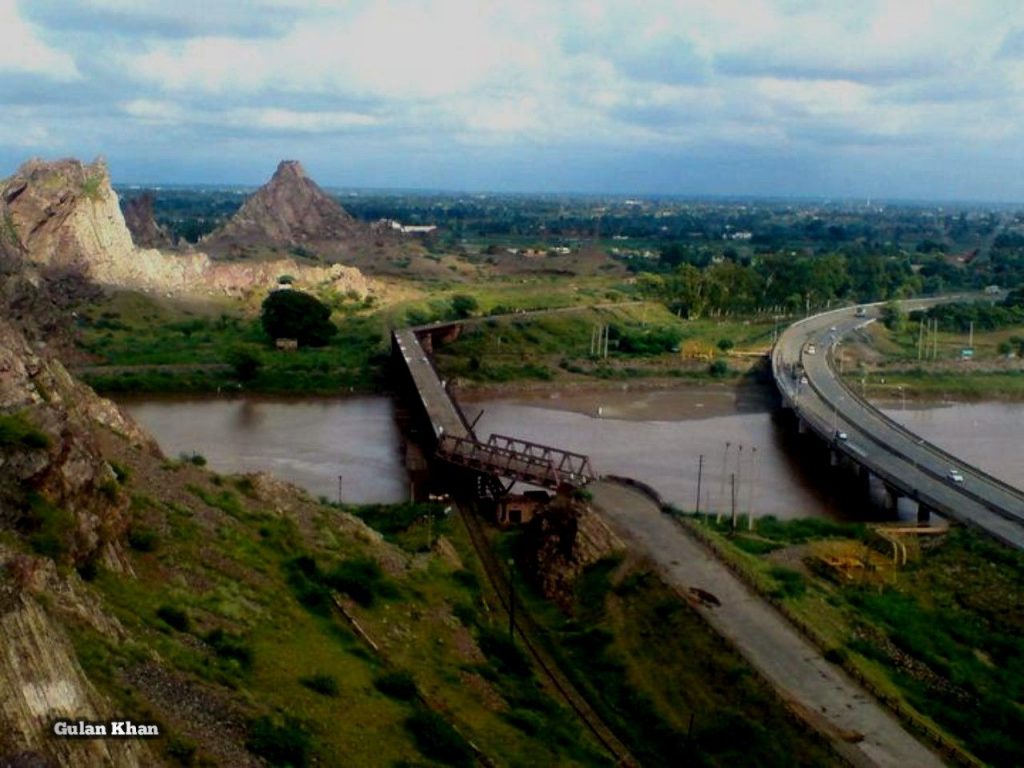
Figure 1.4 A View of Chenab River surrounded by the City’s Infrastructure, Chenab Nagar
Forests; Chiniot district
There is one reserved forest called Chak Bahadur Sarkar Forest in Chiniot district. The following table shows the total forest area under various departments in Chiniot district as per Punjab Development Statistics 2018-19:
| Total Forest Area | 2,631 A | Forests Under Provincial Govt. | 1,141 A |
| Compact Forests under Punjab Govt. | 484 HA | Resumed land | A |
| Linear Plantation | – km | Un-Classed Forests | 1006 A |
Table 1.3 Chiniot Forests
The forests of the district are Riverine Forests. The most common trees of these forests are shisham (Dalbergio sissoo), kikar (Acacia karoo), sumbul (Kapok ceiba), eucalyptus (Eucalyptus cinerea), and mulberry (Morus alba).
Soils of Chiniot district
The soils of the district are fertile, alluvial soils, and can be classified as sandy loam, with sand, silt, and clay.
Climate of Chiniot district
The district has extreme climate. The summer season begins from the month of April and lasts till October. Wind dust storms are common during the summer, but they are not very intense, and do not cause much damage. May, June, and July are the hottest months when the temperature can go up to 45 °C, while minimum temperatures are 18 °C. January and February are the coldest months. The mean minimum and maximum temperatures during this period are about 6 °C and 27 °C respectively.
The Monsoon season starts in June and ends in August. Maximum rainfall is during July. The average annual rainfall is about 290 mm. The district is, however, adjacent to Faisalabad district and the climatic conditions of the two districts are approximately the same.
Seismic Activity/Seismicity; Chiniot district
The district belongs to Zone 2A of the Seismic Zone Map of Pakistan, which means minor to no damage due to earthquakes.
Population of Chiniot District
Population figures for Chiniot district as per 2017 Census are as follows:
| Name | Area km2 | Population | Male% | Female% | Urban% | Growth Rate % |
| Chiniot District | 2,643 | 1,369,740 | 51.1 | 49.9 | 30.8 | 1.86 |
| Bhowana Tehsil | 374,270 | |||||
| Chiniot Tehsil | 556,147 | |||||
| Lalian Tehsil | 439,323 |
Table 1.4 Chiniot Population Statistics
Since this is a newly created district, no other figures are available.
Religions; Chiniot district[1]
| Muslims | 95.4% |
| Christians | 0.5% |
| Hindus | Negligible % |
| Ahmadis | 4.1% |
| Scheduled castes | Negligible % |
| Others | Negligible % |
Table 1.5 Chiniot Religious Composition
Languages; Chiniot district[2]
| Urdu | 2.4% |
| Punjabi | 96.8% |
| Sindhi | Negligible % |
| Pushto | 0.7% |
| Balochi | Negligible % |
| Seraiki | 0.07% |
| Others | Negligible % |
Table 1.6 Chiniot Languages
[1] 1998 Census; 2017 Census results have not been made public yet.
[2] 1998 Census; 2017 Census results have not been made public yet.
Economic Activity – Economic Infrastructure
Economic Activity; Chiniot District
The economy of Chiniot district is based on agriculture.
The major employers of the district[1] are:
- Agriculture with its Allied Livestock Breeding, Fishing (44.4%)
- Construction (33.5%)
- Community, Social & Personal Services (8.3%)
- Wholesale/ Retail, Hotel/ Restaurant (5.7%)
- Manufacturing (3.5%)
- Transport, Storage & Communication (2.0%)
- Others (2.6%)
Land Use; Chiniot district
The following table shows the major land use statistics of the district as per Punjab Development Statistics 2018-19:
| Total Area | 264,300 HA | Reported Area | 263,000 HA |
| Total Cultivated Area | 151,000 HA | Net Sown | 110,000 HA |
| Current Fallows | 41,000 HA | Total Uncultivated Area | 112,000 HA |
| Culturable Waste | 65,000 HA | Forest Area | – HA |
Table 1.7 Chiniot Land Use Statistics
Irrigation Network; Chiniot district
The waters in the irrigation canals of the district are controlled by the Trimmu Barrage. The southern branch of the Lower Jhelum Canal irrigates the western portion of the district while Jhang Branch irrigates the eastern portion.
Other canals providing irrigation water to the district are Chauri Minor, Walaniawala Distributary, Burali Distributary, Saruwala Minor, Aruri Distributary, Sathoi Minor, Yalwala Distributary, Chiniot Distributary, Jamal Jati Distributary, and Tehri Minor.
The following table shows the irrigation statistics as per Punjab Development Statistics 2018-19:
| Total Irrigated Area | 293,000 HA | Un-Irrigated Area | – HA |
| Canal Irrigated | 37,000 HA | Dug Wells Irrigated | 1,000 HA |
| Tube Well Irrigated Area | 106,000 HA | Canal Tube Wells | 145,000 HA |
| Canal Wells | 4,000 HA | Others | – HA |
Table 1.11 Chiniot Irrigation Statistics
Agriculture; Chiniot district
The district belongs to the Northern Irrigated Plains Agro-Ecological Zone of Pakistan. Agriculture is the dominant sector of the economy. Sugarcane, wheat, rice, barley, tobacco, cotton, maize, bajra (millet), jowar (sorghum), guar seed, sunn hemp, gram, moong, maash, masoor, other pulses, rapeseed & mustard, ground nut, sesanum, linseed, sunflower, and fodder are the crops of the district.
Fruits of the district include citrus, mangoes, banana, guava, pomegranate, and dates. Main vegetables are peas, onion, garlic, chilies, coriander, potato, tomatoes, turnip, cauliflower, okra, carrots, and spinach.
Livestock Breeding; Chiniot district
The following table shows the livestock population as of the 2010 Census of Livestock (taken from Punjab Development Statistics 2018-19 for Chiniot district:
| Cattle | 338,000 Heads | Buffaloes | 587,000 Heads | Sheep | 82,000 Heads |
| Goats | 340,000 Heads | Camels | 8,289 Heads | Horses | 15,123 Heads |
| Mules | 1,310 Heads | Asses | 172,397 Heads |
Table 1.8 Chiniot Livestock Statistics
Lohi sheep, thali sheep, beetal goat, beetal spotted goat, nachi goat, barbary goats, and thoroughbred horses are indigenous breeds of the Jhang district. In the absence of any other data, these breeds have been presumed as indigenous to Chiniot district as well.
Poultry Farms; Chiniot district
In Table 17 (Number of Commercial Poultry Farms and Number of Birds by Size of Flock) data for Chiniot district is included in Jhang district, such that both districts have a total of 405 poultry farms. As per Punjab Development Statistics 2018-19 number of privately owned poultry farms in the district are as follows:
- Broiler Farms 37 numbers
- Layer Farms 8 number
- Breeding Farms 1 number
Fishing; Chiniot district
Fishing is carried out in the Chenab River, irrigation canals, and other water bodies.
Bee Keeping/ Apiculture; Chiniot district
In Pakistan, honeybee colonies were introduced in the 1980s; since then, more than 300,000 honeybee colonies have been established in Pakistan, with some thriving in Chiniot as well.
Minerals and Mining; Chiniot district
Iron ore is the only mineral[2] being mined in Chiniot district.
Industry and Manufacture; Chiniot district
Pakistan’s largest conglomerate of industries, the Nishat Group of Industries, is owned by Mr. Mian Mohammad Mansha who is from Chiniot. Other important groups of industries owned by Chiniotis include the Shafi Group, Crescent Group, Sapphire Group, Colony Group, Monnoo Group, Vohra Group, and Brothers Trading Group.
The wooden furniture industry of Chiniot is renowned globally. The handmade carved wooden furniture is exported to various parts of the world. It is the largest cottage industry of the district.
At present, there is no industrial estate in the district, but there are 92 small, medium, and large industrial units. Industry-wise numbers of units in the district are as follows:[3]
| Type of Industry | Number | Type of Industry | Number |
| Cold Storage | 10 | Chips/ Straw Board | 01 |
| Flour Mills | 02 | Foundry Products | 09 |
| Rice Mills | 52 | Electrical Goods | 01 |
| PVC Pipes | 01 | Sugar | 03 |
| Textile Composite | 01 | Textile Spinning | 06 |
| Vegetable Ghee/ Oil | 01 |
Table 1.9 Chiniot Industries
Trade (Import/Export); Chiniot district
The district trades in agricultural produce nationally, and wooden furniture both nationally and internationally.
Handicrafts; Chiniot district
Handicrafts of the district include carved wooden furniture, woven basketry work, stone craft, cloth weaving, and metal crafting as well as leather goods. Carved wooden furniture of Chiniot is renowned globally.

Figure 1.5 Handcrafted Wooden Carvings, Chiniot

Figure 1.6 Handcrafted Wooden Chairs, Chiniot
[1] same as Jhang district
[2] Official website of Punjab Mineral Company (PMC)
[3] Pre-Investment Study Chiniot District 2012, Directorates of Industries, Punjab; Latest available
Economic Infrastructure; Chiniot District
All connected roads in the district are well-maintained. The district is also connected with Lahore, Faisalabad, and Sargodha via railway.
Road Statistics; Chiniot district
The following table shows the road statistics for Chiniot district, as per Punjab Development Statistics 2083-19:
| Total Road Length | 1,327.2 km |
| National Highways | – km |
| Motorways | – km |
| Provincial Highways | 1,327.2 km |
| Sugar Cess Roads | – km |
Table 1.10 Chiniot Road Statistics
Some of the important road links of the district are:
- National Highway (Expressway) E 3
- Motorway M 2 passes through Rabwah (Chenab Nagar)
- Sargodha-Faisalabad Road
- Lahore to Sargodha Road
- Thana Road Lalian
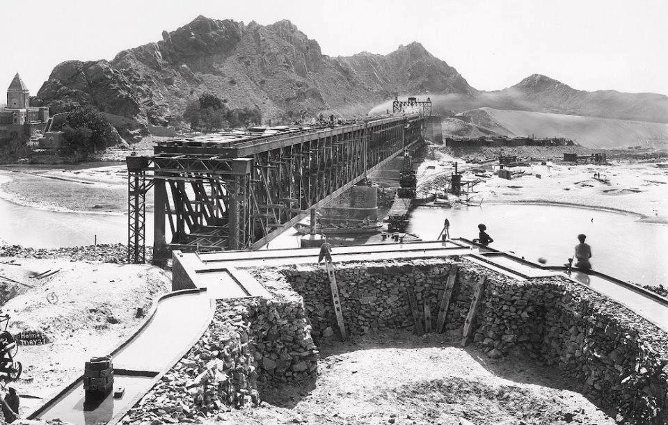
Figure 1.12 Chiniot Railway Bridge under Construction 1930
Rail and Airways; Chiniot district
The district is linked with other parts of Punjab and Pakistan through Pakistan Railways.[1] There is a railway station in Chenab Nagar of Chiniot district. In all, there are 3 railway stations in the district.
There are no airports in the district. The nearest International airport is the Faisalabad airport which is 40 km from Chiniot city.
Radio and Television; Chiniot district
There is a radio broadcasting station in Chiniot city. While there is no TV station in the district, TV can be viewed through cable.
Telecommunications; Chiniot district
Pakistan Telecommunication Ltd. has established a network of telephone lines. There are 17 telephone exchanges[2] ranging in capacity from 206 lines to 7,992 lines.
Post Offices/ Courier Services; Chiniot district
There are 9 Pakistan Post[3] offices in the district with 05 branches in Chiniot tehsil, 1 in Bhowana tehsil, and 03 in Lalian tehsil.
Banking/ Financial Institutions; Chiniot district
There are a total of 35 branches[4] of various banks in the district, with 13 in Chiniot tehsil, 11 in Bhowana tehsil, and 11 in Lalian tehsil.
According to the List of Reporting Bank Branches 2019 by State Bank of Pakistan, the following banks have branches in Chiniot:
- Al Baraka Bank (Pakistan) Ltd.
- Allied Bank Ltd.
- Askari Bank Ltd.
- Bank Alfalah Ltd.
- Bank Al-Habib Ltd.
- Bank Islami Pakistan Ltd.
- Barclays Bank PLC
- Burj Bank Ltd.
- Citi Bank NA
- Deutsche Bank A.G.
- Dubai Islamic Bank Pakistan Ltd.
- Faysal Bank Ltd.
- First Women Bank Ltd.
- Habib Bank Ltd.
- Habib Metropolitan Bank Ltd.
- HSBC Bank Middle East Ltd.
- Industrial and Commercial Bank of China
- Industrial Development Bank of Pakistan
- JS Bank Limited
- KASB Bank Ltd.
- Muslim Commercial Bank Ltd.
- Meezan Bank Ltd.
- National Bank of Pakistan
- National Investment Bank Ltd.
- Oman International Bank SAOG
- SME Bank Ltd.
- Samba Bank Ltd.
- Silk Bank Ltd.
- Sindh Bank Ltd.
- Soneri Bank Ltd.
- Standard Chartered Bank (Pakistan) Ltd.
- Summit Bank Ltd.
- The Bank of Khyber
- The Bank of Punjab
- The Bank of Tokyo-Mitsubishi Ltd.
- The Punjab Provincial Cooperative Bank Ltd.
- United Bank Ltd.
- Zarai Taraqiati Bank Ltd.
In all there are 99 branches of various conventional banks and 08 branches of Islamic banks in the District
Electricity and Gas; Chiniot district
Faisalabad Electric Supply Company (FESCO) looks after the supply and distribution of electricity to the district. There are 05 grid stations in the district (ranging in capacity from 66 KV to 220 KV). Natural gas is available in Chiniot tehsil and Lalian tehsil.
Healthcare Facilities; Chiniot district
The District Health Officer (DHO) is overall in charge of health services provided in the district. The DHO is supported by doctors, paramedics, technicians, and other support staff. The following table shows the number of health care institutions in the district as per Punjab Development Statistics 2018-19:
| Facility | No./Beds | Facility | No./Beds |
| Government Hospitals | 03/150 | Dispensaries | 13/08 |
| Rural Health Centers | 03/60 | Basic Health Units | 36/72 |
| T.B. Clinics | 01/- | Sub Health Centers | -/- |
| Mother Child Health Centers | 02/04 | Private Hospitals | 01/120 |
| Private Healthcare Providers[5] | 49/NA |
Table 1.12 Chiniot Health Care Institutes
Educational Institutions; Chiniot district
The following table shows the details of educational facilities of the district as per Punjab Development Statistics 2018-2019:
| Facility | Boys/Girls | Facility | Boys/Girls |
| Primary Schools | 196/331 | Middle Schools | 38/34 |
| Secondary Schools | 54/44 | Higher Secondary | 02/03 |
| Degree Colleges | 10/07 | Other Higher Secondary[6] | 07/01 |
| Other Degree Colleges[7] | 01/05 | Technical Training Institutes[8] | 02/- |
| Vocational Institutes[9] | -/01 | Commercial Training[10] | 01/- |
| University[11] | 01 | Government Mosque Schools | -/- |
| Medical College | – | Agriculture College | – |
Table 1.13 Chiniot Educational Institutes
Policing; Chiniot district
The Punjab Police operates under the Police Order 2002 and the Police Rules of 1934. There is a Central Police Office at Lahore which has a number of functional units like Finance & Welfare, Establishment, Headquarters, Operations, Training, and Punjab Constabulary, among others. Some of these units report to the Inspector General of Police (IGP) directly while others report to the IGP through the Additional Inspector General of Police (AIGP) Punjab. The Regional Police Officers (RPO) or Range Deputy Inspectors General of Police report to the IGP directly and they do not form a part of the Central Police Office. The Punjab Police is an attached department of the Home Department, Government of Punjab, however the IGP is an ex-officio secretary to the Government of Punjab.
The Punjab Police is staffed by officers of the Punjab Police and the Police Service of Pakistan. The officers of the Punjab Police are grouped into 6 specialized cadres.
Deputy Inspector General Police (DIGP) looks after Faisalabad region which comprises of Faisalabad, Jhang, Toba Tek Singh, and Chiniot districts. Chiniot district is further subdivided into 3 subdivisions with 9 police stations.[12] The police in each region is headed by the District Police Officer (DPO) who is assisted by a varying number of Superintendents and Deputy Superintendents of Police.
[1] Pre-Investment Study Chiniot District 2009, Directorates of Industries, Punjab; Latest available.
[2]Pre-Investment Study Chiniot District 2012, Directorates of Industries, Punjab; Latest available.
[3] Pre-Investment Study Chiniot District 2012, Directorates of Industries, Punjab; Latest available.
[4] Pre-Investment Study Chiniot District 2012, Directorates of Industries, Punjab; Latest available.
[5] Three Years Rolling Plan 2010-13, Chiniot District; Latest available.
[6] Includes Private, Federal and Schools owned by PAF and other organizations
[7] Includes Private, Federal and Schools owned by PAF and other organizations
[8] Pre-Investment Study District Chiniot 2012, Directorate of Industries Punjab; Latest available.
[9] Pre-Investment Study District Chiniot 2012, Directorate of Industries Punjab; Latest available.
[10] Pre-Investment Study District Chiniot 2012, Directorate of Industries Punjab; Latest available.
[11] Campus of National University of Computer & Emerging Sciences (Private)
[12] Punjab Development Statistics 2018-19
Environment and Biodiversity; Chiniot District
Chiniot is located on the bank of River Chenab, and is a mostly rural district, with handicrafts (handcrafted wooden furniture) as its major industry. The major source of air pollution is vehicular transmissions and dust particles.
Flora and Fauna; Chiniot district
Flora; Chiniot district
These are the most common trees in the district: bohar (Ficus Indica), pipal (Ficus religiosa), bakain (Melia azedarach), barna or amaltas (Cathaticarpus fistula), phulai (Acacia modesta), jaamun (Sizygium jambolnum), bahn or ubhan (Populus euphratica), kikar (Acacia Arabica), Kabuli kikar (Acacia cupressi formis or cypress-formed), shisham (Dalbergio sissoo), ber (Zizyphus jujube), siris (Acacia speciosa), white siris (Acacia elata), sirin (Albizzia lebbek), jand (Acacia leucuphelea), aak (Calotropis procera), and vann or jal (Salvadora abeoides) of 2 varieties¾kaura (sour) jal and mitha (sweet) jal¾are particularly popular with local people on account of their fruit called pilu. Sarkanda, Karir bush (Capparis aphylla) with its fruit used as pickles also thrive in various parts of the district. The Munikana is the characteristic plant of Chenab valley. Its leaves are used for thatching houses. In the cold weather, animals also feed on these leaves mixed with grain or oil-cakes called khal.
Fauna; Chiniot district
Mammals found in the forests of the district include hyena, wild cat, lynx, badger or bijou, ravine deer, jackal, fox, wild boar, and hare. Included in game birds are tiliar, sand grouse, goose, duck, partridge, and quail. Wild goose (koonj) also migrates to the area during winter. Several venomous snakes were once commonly found, especially in the area between Chenab and Jhelum but their numbers are on the decline.
The camels of the Bar are of a heavier built than those of the Thal, and hence, can carry heavier loads.
Protected Wildlife Areas and Endangered Fauna; Chiniot district
There are no wildlife protected areas or wetlands in the district. The reserved forest called Chak Bahadur Sarkar Forest provides protection and sanctuary to the fauna of the district.