Share now
Map of Punjab

Map of Rawalpindi District

Punjab Districts
- Islamabad Capital Territory Profile
- Lahore District Profile
- Attock District Profile
- Bahawalnagar District Profile
- Bahawalpur District Profile
- Bhakkar District Profile
- Chakwal District Profile
- Chiniot District Profile
- Dera Ghazi Khan District Profile
- Faisalabad District Profile
- Gujranwala District Profile
- Gujrat District Profile
- Hafizabad District Profile
- Jhang District Profile
- Jhelum District Profile
- Kasur District Profile
- Khanewal District Profile
- Khushab District Profile
- Layyah District Profile
- Lodhran District Profile
- Mandi Bahauddin District Profile
- Mianwali District Profile
- Multan District Profile
- Muzaffargarh District Profile
- Narowal District Profile
- Nankana Sahib District Profile
- Okara District Profile
- Pakpattan District Profile
- Rahimyar Khan District Profile
- Rajanpur District Profile
- Rawalpindi District Profile
- Sahiwal District Profile
- Sargodha District Profile
- SheikhupuraDistrict Profile
- Sialkot District Profile
- Toba Tek Singh District Profile
- Vehari District Profile
Also visit: Sindh, Balochistan, Khyber Pakhtunkhwa
Rawalpindi District Profile
Introduction/Geographical Location; Rawalpindi District
Rawalpindi district, now called Rawalpindi City District is situated between 33° 4Ꞌ to 34° 1Ꞌ north latitudes, and 72° 38Ꞌ to 73° 37Ꞌ east longitudes. The district is bounded on the north by Islamabad Capital Territory, Abbotabad and Haripur districts of NWFP[1] (now Khyber Pakhtunkhwa or KP); on the south, it is bounded by Chakwal and Jhelum districts; on the west by Attock district; and on the east by the River Jhelum across which lies Bagh, Rawalakot, and Kotli districts of Azad Kashmir.
Rawalpindi District at a Glance
| Name of District | Rawalpindi City District | ||
| District Headquarter | Rawalpindi | ||
| Population[2] | 5,405,633 persons | ||
| Area[3] | 5,285 km2 | ||
| Population Density[4] | 1,039 persons per km2 | ||
| Population Growth Rate[5] | 2.5% | ||
| Male Population[6] | 50.7% | ||
| Female Population[7] | 49.3% | ||
| Urban Population[8] | 53.2% | ||
| Tehsils/Autonomous Towns |
08 Towns: 1. Gujar Khan 2. Potohar (Southern Rawalpindi) 3. Taxila 4. Rawal (Northern Rawalpindi) 5. Kallar Syedan 6. Kahuta 7. Kotli Sattian 8. Murree |
||
| Main Towns | Chaklala, Satellite Town, Ghora Gali, Darya Gali, Angori, Murree Urban, Wah, Thatha Khalil, Chohan, Mughal Para, Adiala, and Devi, as well as the towns mentioned above | ||
| Literacy Rate[9] | 83% | ||
| Male Literacy Rate[10] | 90% | ||
| Female Literacy Rate[11] | 76% | ||
| Major Economic Activity[12] | Agriculture with its Allied Livestock Breeding, Fishing | 8.4% | |
| Manufacture | 5.3% | ||
| Construction | 10.3% | ||
| Wholesale/Retail, Hotel/Restaurant | 11.7% | ||
| Transport, Storage, Communication | 2.8% | ||
| Community, Social & Personal Services | 45.3% | ||
| Activities Not Adequately Defined | 15.3% | ||
| Others | 0.9% | ||
| Main Crops | Wheat, maize, jowar, groundnut, bajra, moong, maash, masoor, gram, guar seed, sunflower, rapeseed & mustard, barley, sesanum, sugarbeet, linseed, sunn hemp, castor seed, and walnut | ||
| Major Fruits | Apple, citrus, guavas, mangoes, peaches, pears, apricot, bananas, loquat, ber, mulberry, watermelon, musk melon, plums, loquats, strawberries, and raspberries | ||
| Major Vegetables | Potatoes, onions, okra, bottle gourd, brinjal, turnip, carrot, cauliflower, peas, tomatoes, chilies, garlic, tinda, and radish | ||
| Forests (area)[13] | 58,000 HA[14] | ||
| Total Roads[15] | 3,645.0 km | ||
| National Highways[16] | 97.4 km | ||
| Motorways[17] | 38.0 km | ||
| Provincial Highways[18] | 3,509.6 km | ||
| Sugar Cess Roads[19] | – km | ||
| No. of Grid Stations[20] | 18 grid stations, ranging in capacity from 132 KV to 500 KV | ||
| No. of Telephone Exchanges[21] | 125 telephone exchanges, ranging in capacity from 48 lines to 44,000 lines | ||
| Industrial Zones[22] |
03 Industrial Zones in Rawalpindi: Rawalpindi, Gujar Khan, and Taxila There is a dry port in the district. Total No. of industrial units is 118 |
||
| Major Industry[23] | Flour Mills | 68 Units | |
| Drugs & Pharmaceuticals | 14 Units | ||
| Industrial/Burn Gases | 5 Units | ||
| Food Products | 3 Units | ||
| Poultry Feed | 4 Units | ||
| Textile Spinning | 3 Units | ||
| Chips/Straw Boards, Textile Composite, Tire & Tubes, Woolen Textile & Spinning | 2 Units Each | ||
| Arms & Ammunition, Bakery Products, Beverages, Cement, Chemical, Baby Diapers, Explosives, Fruit Juices, Heavy Engineering, LPG Cylinders, Oil Refinery, Textile Weaving, Tobacco | 1 Unit Each | ||
| Household Size[24] | 6.5 persons per house | ||
| Houses with Piped Water Inside[25] | 41.3% | ||
| Houses with Electricity[26] | 91% (rounded up) | ||
Table 1.1 Rawalpindi District at a Glance
[1] NWFP, or North-West Frontier Province was the original name of Khyber Pakhtunkhwa (KP) province.
[2] 2017 Census
[3] 1998 Census
[4] 2017 Census
[5] 2017 Census
[6] 2017 Census
[7] 2017 Census
[8] 2017 Census
[9] Pakistan Social & Living Measurement Survey 2014-15 (PSLM); Latest available.
[10] PSLM
[11] PSLM
[12] 1998 Census; 2017 Census data has not been made public yet.
[13] Punjab Development Statistics 2018-19
[14] Land Utilization Statistics report 69,000 HA under forests.
[15] Punjab Development Statistics 2018-19
[16] Punjab Development Statistics 2018-19
[17] Punjab Development Statistics 2018-19
[18] Punjab Development Statistics 2018-19
[19] Punjab Development Statistics 2018-19
[20] Directorate of Industries, Lahore. Pre-Investment Study, Rawalpindi District 2012; Latest available.
[21] Directorate of Industries, Lahore. Pre-Investment Study, Rawalpindi District 2012; Latest available.
[22] Directorate of Industries, Lahore. Pre-Investment Study, Rawalpindi District 2012; Latest available.
[23] Directorate of Industries, Lahore. Pre-Investment Study, Rawalpindi District 2012; Latest available.
[24] 1998 Census; 2017 Census data has not been made public yet.
[25] 1998 Census; 2017 Census data has not been made public yet.
[26] 1998 Census; 2017 Census data has not been made public yet.
Brief History – Governmental Structure – Administrative Divisions – Heritage Buildings, Tourist Attractions, Picnic Areas
Brief History of Rawalpindi District
The word Rawalpindi literally means the Village of Rawals. The district has been thus named because it occupies the site of an old village inhabited by Rawal tribesmen.
Ancient History: Antiquity to 8th Century AD – 10th Century to 19th Century – British Raj – 1947 to Present
Ancient History: Antiquity to 8th Century AD; Rawalpindi district
According to the Imperial Gazetteer of India:
In ancient times the whole or the greater part of the area between the Indus and the Jhelum seems to have belonged to a Turanian race called Takkas[1] or Takshakas, who gave their name to the city of Takshasila, the Taxila of the Greek historians, the site of which has been identified to be the ruins of Shahdheri in the north-west corner of the District. At the time of Alexander’s invasion Taxila was described by Arrians[2] as a flourishing city, the greatest indeed between the Indus and the Hydaspes;[3] Strabo[4] adds that the neighbouring country was crowded with inhabitants and very fertile; and Pliny[5] speaks of it as a famous city situated in a district called Amanda. The invasion of Demetrius in 195 BC brought the Punjab under the Graeco-Bactrian kings. Later they were superseded by the Sakas, who ruled at Taxila with the title of Satrap. At the time of Hiuen Tsiang the country was a dependency of Kashmir. (v. 21, p. 264)
In about 500 BC,[6] Darius of Persia (now Iran) conquered this region and made it a part of his empire, including the Gandhara[7] in his empire. Later the people of the district fought as part of the Persian armies against the Greeks. Alexander the Great captured Persia first, and, in 331 BC, marched against Taxila. At this time, the Abisares ruled the areas north of present-day Rawalpindi district and Porus ruled the areas east of Jhelum River. Taxiles ruled the tract between the Indus and Jhelum. After Alexander’s death in Babylon, Chandragupta Maurya rebelled against the Greeks and conquered the area. The Mauryans ruled the area for about a century and half (322 BC-185 BC). During their rule, and especially during the rule of Ashoka, Buddhism became the dominant religion of the area and Ashoka built a number of stupas[8] in different locations of his empire.
In 190 BC the Bactrian Greeks led by Demetrius conquered Taxila. The Greeks ruled this area for about a century. In 78 AD, the soldiers of this area allied themselves with the Kushans and fought alongside them to help expand their empire over Kashmir, Kashghar, Khotan, Kabul, and a considerable part of India. The Kushans promoted art and thus, during their rule, Gandhara art flourished. The rise of Sasanian[9] power in Persia and Gupta power in India weakened the Kushans.
In the Rawalpindi region, Kushan rule persisted for another century, and then the area came under the White Huns. After the Huns, various Rajput tribes of the area started forming and ruling small Principalities. By the 7th century AD the ancient glory of Taxila and Gandhara had dwindled, and Brahmanism had started gaining power, while the Rawalpindi district became a Principality of Kashmir. In the 8th Century AD, this region became part of the Hindu Shahi Kingdom of Kabul.
10th Century to 19th Century; Rawalpindi district
Mahmud of Ghazni crossed the River Indus in 1008 AD and fought a battle in the Plains of Chachh near Hazro and Attock on the Indus. This battle brought the end of Hindu Raj (rule) in this area. Mahmud of Ghazni was accompanied by Gakkar Shah, the chief of the Gakkar tribe.[10] Ghazni bestowed this district on him and the Gakkars settled in the area, ruling it for 8 centuries. In 1205 AD, Shahab-ud Din Ghori attacked the area. He defeated the Gakkars but met his end in this district when he was killed in an ambush on his camp at night. The Ghakars converted to Islam en-masse in 1205 AD, and maintained their stronghold in the region.
In 1342, during the reign of Sultan Mahmood bin Tughluq, Malik Haider (a Gakkar Chief) invaded Punjab and killed Tatar Khan, Tughluq’s viceroy of Lahore. Haider was later defeated by the army of Khwaja Jahan, the Wazir (minister) of Sultan Mahmood bin Tughluq.
When Amir Taimur[11] invaded India in 1398, he crossed River Indus at Attock. The areas belonging to the Gakkars came under his dominion.
Babar, the first Mughal Emperor, defeated the then Gakkar Chief, Hathi Khan. His cousin Sarang Khan then poisoned Hathi Khan and, on gaining leadership of the tribe in 1525, made his submission to Emperor Babar, sending a Gakkar force to accompany him to Delhi He was thus given the Potowar region as his jagir.
In 1541 AD Sher Shah Suri drove Emperor Humayun from India and built the famous fort of Rohtas where he placed a garrison of strong men under Khwas Khan. Sarang Khan, the ruler of the Potowar region, kept this garrison in a perpetual state of war, driving off convoys and destroying the country around the fort. Later, when Humayun re-entered Delhi, Sarang Khan accompanied him, and then supported Emperor Akbar the Great who succeeded Humayun, remaining loyal to all the Mughal emperors, which allowed him to retain independence. Thus, the Gakkars were supreme not only in this region, but held high offices in the Mughal Darbar at Agra and Delhi. When Ahmad Shah Durrani fought the battle of Panipat against the Mughals (called the Third Battle of Panipat, fought in 1761), the soldiers of this district were in the forefront of the Mughal forces.
Ultimately, the district came under Sikh rule in 1810, and the Gakkars were reduced to absolute poverty. During Sikh rule, in fact, all Gakkar chiefs and nobles were gunned down by Sikh Sardars (leaders) including Budh Singh, and Raja Gulab Singh of Jammu. Rawalpindi itself was seized by Ranjit Singh in 1814 and all the estates in Rawalpindi and the district passed into the administration of the central Sikh power in Lahore. In March 1849, after the Second Anglo-Sikh war, the district was annexed to the British Government.
British Raj; Rawalpindi district
During the War of Independence of 1857, the people of the district fought valiantly against British domination, but were defeated. The people of Murree attacked the Murree Garrison, with nearly all the tribes as well as the Muslim tribes living around and near Murree simultaneously attacking the garrison, but were repulsed due to the duplicity of one of Lady Lawrence’s attendants named Hakim Khan who was himself an influential man among the tribes who were rebelling. This betrayal was much appreciated by the British. In the aftermath of this war, the leaders of the rebellion were executed by cannon fire and a large number of tribesmen were hanged. A number of villages were burnt to the ground.
The British then established a cantonment at Rawalpindi. The railway was brought to Rawalpindi in 1866 and Municipal Committees were constituted in 1867.
In the beginning of the 20th century, Rawalpindi became a refuge for Shah Shuja, the exiled Amir of Kabul and his brother Shah Zaman. At that time, Rawalpindi district extended from Jhelum to the Indus and comprised 7 tehsils. In 1904, Rawalpindi district was divided into 2 districts: Attock and Rawalpindi, giving Rawalpindi district its present shape and area.
During the Khilafat Movement[12] Rawalpindi was the base of the Hijrat Movement.[13] In the aftermath of the Jalianwala Bagh[14] incident, there was a good deal of agitation in the district, telegraph services were cut, and many government buildings were burnt. In 1910, a Peace Treaty was signed between Afghanistan and India to end the Afghan War and peace was restored in the district.
1947 to Present; Rawalpindi district
Rawalpindi became the Headquarters of the Pakistan Army in 1947, after Independence. Since then the district is known for its love of armed forces and the bravery of its people. In fact, 6 of the 8[15] Nishan-e-Haider Awards[16] have been awarded to soldiers hailing from the Rawalpindi district.
In 1951, Rawalpindi saw the assassination of the first elected Prime Minister of Pakistan, Liaquat Ali Khan in Company Bagh, now known as Liaquat Bagh (also called Liaquat Garden). In 1959 Rawalpindi became the interim capital of Pakistan, and this attracted investments to the city as most major central government offices and institutions were relocated from Karachi to Rawalpindi. The city remained the capital of Pakistan till 1962, when construction of Islamabad was completed and the new city was declared the capital.
The former Prime Minister of Pakistan, Zulfikar Ali Bhutto, was hanged in Rawalpindi in 1979. On 27 December 2007, Liaquat Bagh’s rear gate in Rawalpindi was the site of the assassination of former Prime Minister Benazir Bhutto.
Rawalpindi remains the headquarters of the Pakistani Army, and Pakistan Air Force also has an active airbase in the Chaklala region of Rawalpindi.
In 2001, under the National Reconstruction Bureau, the district was made a City District and its tehsils were given the status of Autonomous Towns.
Taxila; Rawalpindi district
Taxila is a town of Rawalpindi district which dates back to the Gandhara Civilization and contains the ruins of the Gandharan city of Takṣaśilā which was an important Hindu and Buddhist center, and is still considered a place of religious and historical sanctity in those traditions. It is a vast serial site that includes a Mesolithic cave as well as the archaeological remains of early settlement sites, Buddhist monasteries, and a Muslim mosque and madrassa. It is now one of the most important archaeological sites in Asia. The archaeological sites of Saraikala, Bhir, Sirkap, and Sirsukh (all near Taxila) are collectively of unique importance in illustrating the evolution of urban settlement in the Indian subcontinent.
The Bhir Mound is the earliest historic city of Taxila, and was probably founded in the 6th century BC by the Achaemenid Dynasty. It represents the earliest forms of urbanization in the subcontinent and is also associated with Alexander the Great’s triumphant entry into Taxila in 326 BC.
Sirkap was a fortified city founded during the mid-2nd century BC. The city was destroyed in the 1st century by the Kushans, a Central Asian tribe. Buddhist monuments erected throughout the Taxila valley transformed it into a religious heartland and a destination for pilgrims from as far afield as Central Asia and China.
Taxila was the site of one of the first universities in the world and is listed on the UNESCO World Heritage sites.
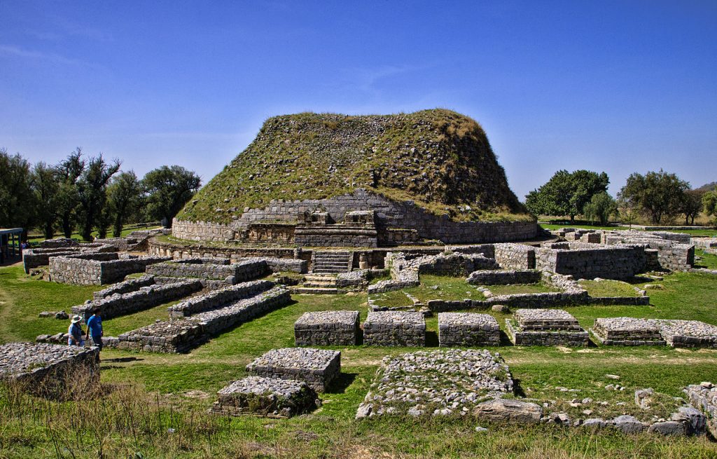
Figure 1.3 The Dharmarajika stupa, Taxila
Governmental Structure; Rawalpindi district
At the Federal level, Rawalpindi district is allocated a set number of representatives in both the National Assembly and the Provincial Assembly:
- Number of seats in the National Assembly 7
- Number of seats in the Provincial Assembly 14
Under the Local Government and Community Development Rawalpindi district has 1 District Council, 2 Municipal Corporations, and 5 Municipal Committees. The Municipal Corporations are as follows:
- Municipal Corporation Rawalpindi
- Municipal Corporation Murree
The Municipal Committees are:
- Kotli Sattian
- Kahuta
- Kallar Syedan
- Gujar Khan
- Taxila
Administrative Divisions; Rawalpindi district
Rawalpindi district has a total area of 5,285 km2 which is divided into 8 Autonomous Towns and a cantonment as follows:
| Rawal Town (Northern Rawalpindi) | 46 Union Councils |
| Gujar Khan Town | 33 Union Councils |
| Potohar Town (Southern Rawalpindi) | 36 Union Councils |
| Murree Town | 15 Union Councils |
| Taxila Town | 10 union Councils |
| Kahuta Town | 14 Union Councils |
| Kallar Syedan Town[17] | 11 Union Councils |
| Kotli Sattian Town[18] | 10 Union Councils |
Table 1.2 Rawalpindi Administrative Divisions
[1] Takkas were snake worshippers and founded Taxila.
[2] Arrians was a Greek historian of the Roman period
[3] Ancient name of River Jhelum
[4] Strabo (63 BC to 24 AD) was a Greek geographer, philosopher, and historian who lived in Asia Minor; he is the author of the Encyclopedia Geographica
[5] Pliny or Plinythe Elder was a Roman historian and Naval and Army Commander of the early Roman Empire. He is the author of the Encyclopedia of Natural History (Naturalis Historia)
[6] The following account of Rawalpindi district’s ancient history has drawn heavily from Punjab District Gazetteers, Rawalpindi District 1907 by Punjab Government and 1998 District Profile Rawalpindi by Government of Pakistan
[7] Gandhara was the name of a region and its associated civilization. It existed in what is now northern Pakistan and Afghanistan from the mid-1st millennium BC to the beginning of the 2nd millennium AD and consisted of multiple dynasties which ruled over the same area but that were linked by their adoption of Buddhism as a religion and also of the Indo-Greek artistic tradition as its cultural identity.
[8] A stupa is a mound containing relics of Buddhist monks and is used as a place of meditation.
[9] The Sasanian Empire was the last Persian Empire before the rise of Islam, and lasted from 224 to 651 AD
[10] The Gakkars are a Punjabi tribe claiming to be of Persian ancestry. They are descendants of Sultan Kaid, son of Gohar or Kaygohar, a native of Kayan in Isphahan; there are two versions of their entry into India with Mahmud of Ghazni; one account says that the Gakkars were already settled in India by 682 AD and they fought Ghazni and nearly defeated him. Another account, considered to be more authentic, says they accompanied Ghazni when he arrived to conquer the region. The history of Rawalpindi, thus, is mostly the history of the Gakkars.
[11] Turkish ruler who founded the Timurid Dynasty and conquered West, South, and Central Asia
[12] The Khilafat Movement (1919-1924) was a movement in India to safeguard the Ottoman Empire and all religious monuments and buildings in Turkey launched after the end of the First World War (1914-18). The Muslims of India had sided with the British Government during the War on the promise and agreement that the British would restore the Ottoman Empire after the War. When the British reneged on the promise, the Muslims started the Khilafat Movement.
[13] The Hijrat Movement was a by-product of the Khilafat Movement and was launched in 1920 as a protest against British Policies. Muslims were urged by people like Maulana Abul Kalam Azad and Maulana Abdul Bari to migrate to places like Afghanistan where (it was presumed) their religion and national image would not be jeopardized.
[14] The Jalianwala Bagh massacre took place in Amritsar, Punjab, during a peaceful protest to condemn the arrest and deportment of two national leaders, Satya Pal and Dr. Saifuddin Kitchlew. The protest took place on 13 April 1919. According to Indian historians, the British army opened fire on the unarmed protestors, killing thousands.
[15] Rawalpindi District Profile by Go Pakistan 1972
[16] The Nishan-e-Haider Award is Pakistan’s highest Military gallantry award. The word literally means “Mark of the Lion.”
[17] Kallar Syedan is a newly constituted town. Earlier, it was a part of Kahuta tehsil. It was made a tehsil in 2007
[18] Kotli Sattian was originally a part of Murree Town
Heritage Buildings/Tourist Attractions/Picnic Areas; Rawalpindi district
There are 17 buildings in Rawalpindi district that have been declared as heritage/ protected buildings by the Federal Government of Pakistan; in addition, 2 buildings are protected by the Provincial Government of Punjab. The Archaeological Remains at Taxila are considered to be World Heritage Monument on the UNESCO list.[1] The following buildings are protected under Federal Government bylaws:
- Mankiala Topa or stupa (Buddhist)Rawalpindi district: This is a Buddhist archaeological site dated around 128-151 AD, situated at the crest of a high hill. Popular legends ascribe this place to Raja Rasalu (legendary founder of Sialkot) as a seat of rakhshas, and refer to it as Manikpur or Maniknagar. The stupa itself is 28 m high and was once regarded as one of the four great stupas of the Subcontinent
- Bhallar Topa or stupa (Buddhist)Rawalpindi district: This stupa is located on the top of the Sarada Hill, beyond the Haro River. This is the tallest stupa in Taxila, and is believed to have been built in the medieval period. Coins of Indo Assarians and the Huns have been discovered. The main stupa has a cruciform plan, consisting of a tall, square base for the dome, above which off-set projections for the steps can be seen on all four sides. The Corinthian pilasters divide the plinth into bays. A statue of Buddha in a sleeping pose was found in one of these bays, and is now housed in Taxila Museum. The monastery is of the Jaulian type
- Pharwala Fort, Pharwala; Rawalpindi district: This fort is naturally defended on one side by a small Himalayan Range and on the other by theSoan River. It is a Gakkar fort, built in the 15th century on the ruins of a 10th century Shahi Fort. The Mughal Emperor Babar conquered the fort in 1519; however, after the Mughals reconciled with the Gakkars, the fort was returned to them. Later, in 1825, Sikhs expelled the Gakkars from this fort. The fort is in bad shape. Situated in the Kahuta area, it is only open to Pakistani visitors. A small community of the Kiani Gakkar tribe lives inside the fort these days. An old and huge Banyan tree is also found inside the fort
- Losar Baoli, Wah Cantonment; Rawalpindi district: Located near Margala Hills, this step well is thought to have been constructed by the Emperor Sher Shah Suri in order to facilitate the caravans moving toward Kabul via Taxila
- Bhir Mound, Taxila;Rawalpindi district: This mound is part of Taxila; the ruins of Bhir Mound were first excavated from 1913 to 1925 by SirJohn Marshal. It was then excavated by different teams over time, including one led by Sir Mortimer Wheeler in 1944-1945, the next by Dr. Mohammad Sharif in 1966-1967, then by Bahadur Khan in 1998-2000, and finally by Dr. Ashraf and Mahmud-al-Hassan in 2002. The oldest part or layer of these ruins is now known to be from the 6th and 5th centuries BC; these are believed to be the remains of Persian/ Achaemenid Taxila. The second layer is from the 4th century BC and existed at the time of the invasion by Alexander the Great. The third layer is from the time of the Maurya Kings of India (3rd century BC). The fourth and topmost stratum contains the constructions from the time following the Mauryan period
- The tract known as Babar Khan, Taxila; Rawalpindi district
- Kalawansite, Mouza Karawal;Rawalpindi district
- Chir Topa Site, Taxila; Rawalpindi district: This site is also known as the Dharmarajika Stupa. Taxila, meaning “the city of cut-stone,” was the capital of Gandhara. It was a center of Buddhist learning and was known for its teachers
- Sirkap Site, Mauza Gangu Bahadur, Taxila: The city of Sirkap was built by the Greco-BactrianKing Demetrius after he invaded ancient India around 180 BC. Demetrius founded an Indo-Greek kingdom in the northern and northwestern areas of modern Pakistan that lasted until around 10 BC. Sirkap is also said to have been rebuilt by King Menander I
- Giri Remains, Mauza Khurram, Gujar Khan; Rawalpindi district: This site consists of a group of Buddhist establishments, a fort, a Muslim Ziarat, and mosques, all ranging from the early Kushan period (around 230 BC) to the time of Akbar (1556-1605). The Buddhist constructions fall into 2 groups: the eastern and the western. The eastern group, which stands just above the spring, consists of a stupa in the north and a monastery in the south. The western group consists of a stupa of square shape in the north and a monastery in the east. To the north of the monasteries are mosques, ziarats (shrines), and a rocky hill strengthened by a fort wall with semi-circular bastions. Inside this fort-like structure, there are remains of dwellings and other structures. The fortification belongs to a time much later than that of the Huns
- Mohra Maradu Site, Taxila; Rawalpindi district: Here a ziarat associated with the name of Panch Pir (Five Saints) is located
- Rawat Fort, Village Rawat; Rawalpindi district: This fort was built in the early 16th century bythe Gakkars, to defend the Potowar It is 17 km east of Rawalpindi on the Grand Trunk Road. The fort was the scene of a battle between the Gakkar chief Sultan Sarang and Afghan King Sher Shah Suri in 1546 AD
- Nicholson Column, Margalla Pass; Rawalpindi district: This is a monument erected in 1868 in honor of Brigadier-GeneralJohn Nicholson, a famous military figure of the British Empire
- Kos Minars, Milestone 102, G.T. Road, Rawalpindi: Also referred to asMile Pillars, the Kos Minar are medieval milestones that were installed first by the 16th century Afghan King Sher Shah Suri and later by Mughal emperors
- Kos Minar, near Golara Railway Station, Rawalpindi
- Farogh-e-Shahan-e-Mughlia, Tank and Garden, Wah Cantonment;Rawalpindi district
- Ratta Pind (village), Gangu Bahadur;Rawalpindi district
The following buildings have been declared as Special Premises by the Provincial Government of Punjab:
- Entrance Gate of Sarai Kala; Rawalpindi district
- Sarai Kharbuza; Rawalpindi district
Other places of interest in Taxila are the Hatial, which is northeast of Bhir Mound, Karmal near Chir Topa, and Kutcha Kot, which is a mud fort located north of Sirkap. Also of note are the following:
- Liaquat Memorial; Rawalpindi district: This monument commemorates the death of Quaid-e-Millat Liaquat Ali Khan and is located within Liaquat Gardens
- Ayub National Park: Also called Tope Rakh; Rawalpindi district, this park features many artificial canals, waterfalls, fountains, and picnic areas
- Pakistan Ordinance Factory, Wah Cantt; Rawalpindi district
- Murree Hills and areas surrounding it like Patriata, Bhurban, Kashmir Point, Pindi Point, Upper and Lower Topa, Gharyal, Ghora Galli, and Kuldana;Rawalpindi district
- Riverbanks of Haro River, Soan River, Korung River, and Jhelum River; Rawalpindi district
- Lakes of the small dams such as Rawal Lake, Simly Dam Lake, Khanpur Dam Lake, and Tanaza Dam Lake;Rawalpindi district
- Rawalpindi Public Park, Jinnah Park, DHA Jungle Park, Rumi Park, Shah Balot Park, Race Course, Lalazar Park, Children & Ladies Park, Murree-Kotli Sattian-Kahuta Park, and Loi Bher Park, Rawalpindi
- Ancient Hindu, Zoroastrian, and Sikh temples as well as Shrines of Muslim Saints; Rawalpindi district
- Museums and art galleries such as Lok Virsa, Pakistan Museum of Natural History and the Idara-e-Siqafat-e-Pakistan. Other notable museums include the Pakistan Army Museum, and Taxila Museum; Rawalpindi district
- Sports stadiums for cricket and hockey, among others; Rawalpindi district
- The Khyber Steam Safari was a tourist train running between Peshawar and Attock Khurd, and travelled along the main Karachi-Peshawar Railway line. This was discontinued in 2006 due to Monsoon Damage but plans are underway for its revival

Figure 1.9 Steam Safari getting ready to leave Taxila Railway Station

Figure 1.10 Gate of Pharwala Fort facing Soan River

Figure 1.11 A View of the Losar Baoli at Taxila

Figure 1.12 Nicholson’s Obelisk

Figure 1.13 Kos Minar

Figure 1.14 Cable Cars, Patriata

Figure 1.15 Simly Dam Rest House

Figure 1.16 Chattar Park, Murree

Figure 1.17 Nathia Galli in Winter
[1]Guidelines for Sensitive and Critical Areas, Government of Pakistan, 1997
Topography of Rawalpindi District
Rawalpindi district is divided into 3 distinct portions:
- Mountainous region: This contains the hills of Murree, the northern portion of Kahuta, and Kotli Sattian Hills
- The Piedmont Plains or the sub-montane areas of Rawalpindi: These extend up to Kahuta and the west bank of River Jhelum, then down into Gujar Khan Town till it reaches the borders of Jhelum district
- Plains or Potowar: The plains include the area of Rawalpindi Town on the southwest of Murree, and the entire Gujar Khan Town except its hilly areas on the bank of Jhelum and the southeastern portion of Kahuta town
Mountainous Region; Rawalpindi district
The hills of Murree and Kahuta consist of a series of spurs which also include the Margalla Range (Islamabad district). These hills gradually end in the low Bagham hills in Gujar Khan Town and are a part of the outer Himalayas, gradually falling in height from the peaks of Kashmir in the north to Bagham hills in the south. The Murree and Kahuta hills consist of 5 main spurs that are more or less parallel to each other, running sharply down to Jhelum River. These 5 spurs are Murree, Charihan, Paphundi or Patriata, Kotli, and Utrina.
The Murree spur is the highest spur, forming the outer part of the Himalayas, and houses the Murree city at a height of 2,286 m. Various streams run westward into the Plains from these hills. Parallel to the Murree spur is the Charihan spur, which is a few hundred meters lower in height than Murree Hills. The next spur is the Paphundi or Patriata spur, which is at a height of about 2,134 m above mean sea level. The Soan River flows through this spur and its top runs down northeastward spreading in a continuous lofty crest for about 24 km up to Jhelum River. The Kotli spur lies to the east of the Patriata spur. It rises to its highest point (1,856 m or 6,090 feet) in the south, in Kahuta town, in the plateau of the Narar Mountains. The last spur, the Utrina spur, is lower than the others; its highest point is 1,158 m (3,800 feet). This spur forms the boundary between the mountainous and hilly portions of Kahuta town.
Piedmont Plains or Sub-Montane Tract; Rawalpindi district
The sub-montane or Piedmont Plains are located immediately below the mountainous portion, and stretch in a horse-shoe shape from west to east such that the western and northern portions of Rawalpindi town and the central portion of Kahuta town are included this section. This portion can be described as broken and hilly throughout its area.
Plains of Potowar Plateau; Rawalpindi district
The remaining portion of the district is an integral part of the great Potowar Plateau, which stretches south from the Soan River in Rawalpindi town and includes nearly all of Gujar Khan Town and the southern part of Kahuta town. It then runs through the Jhelum tehsil down to River Jhelum. River Soan is the northern boundary of the Potowar Plateau and River Jhelum is its southern boundary.
Thus, Rawalpindi is located in the Salt Range and Potowar Plateau area of Punjab. The terrain surrounding the city can be described as rolling to hilly, crisscrossed by ravines and nullahs flowing out from these hills. The highest areas are in the northwestern and southeastern parts (1,043 and 660 m above sea level, respectively). The terrain of Rawalpindi gradually tapers off toward Lai Nullah in the west and the Korung River in the east. Lai Nullah enters the city from the southwest and joins the Soan River in the southern side. Occasionally, the Lai Nullah overflows during the rainy season, causing considerable damage.
Rivers, Streams, and Lakes; Rawalpindi district
The River Jhelum skirts the district from its northern-most point to its southern boundary. Since its course runs between mountains and rocks, the flow is interrupted by numerous rapids which make it incapable of navigation by boat above Donga Gali (in Abbottabad).
The River Soan flowing from the Murree Hills joins River Indus below Makhad. The Leh or Lai stream (nullah) rises from Saidpur Hills and joins River Soan.
Haro River rises near Donga Gali in Abbottabad district, and after passing Haripur district, enters Rawalpindi; after covering a short distance in Rawalpindi, the river enters Attock tehsil.
Korung River rises near Ghora Gali (near Murree), and flows along the Murree-Rawalpindi Road. The Rawal Dam has been built across this river. This river joins River Soan near Sihala.
One of the notable streams (nullahs) is the Kanshi stream, which rises from Kahuta Hills, drains Gujar Khan Town and joins River Jhelum. Ling Nullah rises from Lehtrar Hills, passes Kahuta town and joins River Soan. The Sarin Nullah rises from Kahuta Hills and then joins Kanshi stream. Gumrah Nullah rises from Punjar Hills close to Rawalpindi and joins the Ling Nullah. Tamrah Nullah rises from Margalla Hills, passes through Taxila and joins Haro River.
The most important marsh in the district is the Khanna Dhak. Other marshes are located near Sohan village and Gangal village.
There is no natural lake in the district but due to the Rawal Dam on River Korung, a lake called Rawal Lake has been formed.
Some of the intermittent streams of the district include Machhiawali Kas, Pharwada Kas, Jabba Kas, Allahwala Kas, Ladvewala Kas, and Ariwala Kas.
Forests; Rawalpind district
A total area of 126,000 HA is under the jurisdiction of the Forestry Department in Rawalpindi district. The following table shows the total forest area under various departments in the district as per Punjab Development Statistics 2018-19:
| Total Forest Area | 143,652 A | Under Provincial Govt. | 45,077 A |
| District Govt. | A | Reserved Forests | 86,548 A |
| Unclassed Forests | 7,594 HA | Resumed Land | 896 A |
| Misc. Forests | 3,537 A | Linear Plantation | 110 km |
Table 1.3 Rawalpindi Forests
There are Evergreen Coniferous Forests, Deciduous Forests, and Scrub Forests in the district. The Evergreen Coniferous Forests are found in the Murree and Kahuta towns. The Scrub Forests are found in the Potowar part of the district. Some Deciduous and Riverine Forests are also found in the district.
The main trees in the Evergreen Coniferous Forests are deodar (Cedrus deodara), spruce (Picea), chir (Pinus roxburghii), fir (Abies balsamea), and blue pine (Pinus walliciana).
The main trees in the Deciduous Forests are phulai (Acacia modesta), kao (Olea ferruginea), chestnut (Aesculus indica), Juniper (Juniperous), walnut (Juglans), aak (Quercus), maple (acer), poplar (populous), olea (wild olives) and chir (Pinus roxburghii).
The main flora of the Scrub Forests includes kahu (Olea ferruginea) and phulai (Acacia modesta).
Some of the Scrub Forests include the Rumair Reserved Forest (RF), Margala RF, Salanga Forests, Jhila Cherah, Las, Jawand, Nalasher, and Banihal. Some coniferous and Scrub Forests of the district are Beorkhalol, Kultia, Keral, and Sang. Coniferous forests include Bhangal, Danoi, Khanwas, Kamra, Kotli, Patriata, Kohatti, Masot, Ghora Gali, Chakka, Bhurban, Gharyal, Kuldana, Kashmir Point, Chittamore, and Pail. Unclassed Forests include Loi Bher, Adiala, and Takhat Pari.

Figure 1.4 Coniferous Forests, Donga Gali
 Figure 1.5 Patriata Evergreen Forests
Soils; Rawalpindi district
Clay soils in the district exhibit 5 distinct strata. They are (from south to north):
- coarse pebbles with sand or clay
- an alluvial stratum deposited by an older river system in the Soan Basin
- alluvial deposits of the present river system
- an airborne top layer of silt or clay (loess)
- conglomerate and loose gravel deposits.
Silty, sandy gravel in medium-dense to dense conditions exists below the topsoil cover of sandy silt.
Climate; Rawalpindi district
Rawalpindi features a humid subtropical climate, with long and very hot summers, a Monsoon, and short, mild, wet winters. There is a wide variation of climate among various parts of the district. The Murree and Kotli Sattian towns have severe winter and mild summers, while Gujar Khan, Rawalpindi, and Taxila towns have a hot summer and relatively mild winters.
In the Potowar region of the district, the summers are hot and winters are quite cold. June is the hottest month, when the mean maximum temperature reaches 39 °C, while the mean minimum temperature during winter goes down to between 0 to -1 °C.
There are 2 rainy spells in the district, one of which is the Monsoon, which begins in July and ends in September. There are far more rains in the eastern part of the district than the western, and rain falls on one side of Margalla Hills but not on the other. The other rainy season starts in January and lasts till the beginning of March.
In Murree, the average rainfall is about 1,142 mm, with about 140 rainy days in a year. In the Plains, the mean average annual rainfall is about 913 mm.
Seismic Activity/Seismicity; Rawalpindi district
The district belongs to Zone 3 of the Seismic Zone Map of Pakistan. This means moderate to severe damage to property due to earthquakes.
Population of Rawalpindi District
The following table shows the population of the district and its tehsils as per 2017 Census:
| District/Tehsil | Area km2 | Population | Male% | Female% | Urban% | Growth Rate % | |||||
| Rawalpindi District | 5,285 | 5,405,633 | 50.7 | 49.3 | 53.2 | 2.52 | |||||
| Gujar Khan Tehsil | 1,457 | 678,503 | |||||||||
| Kahuta Tehsil | 1,096 | 220,576 | |||||||||
| Kotli Sattian Tehsil | 304 | 119,312 | |||||||||
| Murree Tehsil | 434 | 233,471 | |||||||||
| Rawalpindi Tehsil[1] | 1,682 | 3,258,547 | |||||||||
| Taxila Tehsil | 312 | 677,951 | |||||||||
| Kallar Syedan Tehsil | Included in Kahuta Tehsil | 217,273 | |||||||||
Table 1.4 Rawalpindi Population Statistics for Tehsils
Religions; Rawalpindi district[2]
| Muslims | 97.7% |
| Christians | 2.1% |
| Hindus | Negligible % |
| Ahmadis | 0.14% |
| Schedule Castes | Negligible % |
| Others | Negligible % |
Table 1.6 Rawalpindi Religions
Languages; Rawalpindi district[3]
| Urdu | 7.4% |
| Punjabi | 83.8% |
| Sindhi | 0.7% |
| Pushto | 5.3% |
| Balochi | Negligible % |
| Seraiki | 0.4% |
| Others | 2.8% |
Table 1.7 Rawalpindi Languages
[1] Includes Rawal Town and Potohar Town
[2] 1998 Census; 2017 Census has not been made public yet.
[3] 1998 Census; 2017 Census has not been made public yet.
Economic Activity – Economic Infrastructure
Economic Activity; Rawalpindi District
Rawalpindi is one of the more important cities of Pakistan. After the weakening of the Mughal Dynasty, Sikhs gained power in this area and invited nearby traders to live in the city. The city, thus, became a hub of trade due to its strategic location, connecting Punjab and Kashmir.
As per the 1998 Census (2017 Census has not been made public yet), the major industrial occupations in the district are:
- Agriculture with its Allied Livestock Breeding, Fishing (8.4%)
- Manufacture (5.3%)
- Construction (10.3%)
- Wholesale/ Retail, Hotel/ Restaurant (11.7%)
- Transport, Storage, Communication (2.8%)
- Community, Social & Personal Services (45.3%)
- Activities Not Adequately Defined (15.3%)
- Others (0.9%)
Land Use; Rawalpindi district
The following table shows the main land use statistics of the Rawalpindi district as per Punjab Development Statistics 2018-19:
| Total Area | 528,500 HA | Reported Area | 525,000 HA |
| Total Cultivated Area | 231,000 HA | Net Sown | 165,000 HA |
| Current Fallow | 66,000 HA | Total Uncultivated Area | 294,000 HA |
| Culturable Waste | 83,000 HA | Forest Area | 69,000 HA |
Table 1.8 Rawalpindi Land Use Statistics
Irrigation Network; Rawalpindi district
The district depends on rains for irrigation. The Rawal Dam provides waters to 2 irrigation canals in Rawalpindi district. There is no major irrigation system in place, however. There are a number of small dams like the Misriot Dam, Dungi Dam, Simly Dam, Khanpur Dam, and Tanaza Dam, that are fed mostly by rains and melting snow and that irrigate small areas of the district.
The following table shows the modes of irrigation and area irrigated by each in the district as per Punjab Development Statistics 2018-19:
| Total Irrigated Area | 10,000 HA | Un-Irrigated Area | 205,000 HA |
| Canal Irrigated | 2,000 HA | Dug Wells Irrigated | 6,000 HA |
| Tube Well Irrigated | – HA | Canal Tube Wells | – HA |
| Canal Wells | 1,000 HA | Others | 1,000 HA |
Table 1.11 Rawalpindi Irrigation Statistics
Agriculture; Rawalpindi district
Rawalpindi district belongs to the High Rainfall area of Pakistan and hence agriculture is dependent upon rainfall.
The crops of the district include wheat, maize, jowar, groundnut, bajra, moong, maash, masoor, gram, guar seed, sunflower, rapeseed & mustard, barley, sesanum, sugarbeet, linseed, sunn hemp, castor seed, and walnut.
Fruits grown in the area include apple, citrus, guavas, mangoes, peaches, pears, apricot, bananas, loquat, ber, mulberry, watermelon, musk melon, plums, strawberries, and raspberries.
Vegetable produce of the area includes potatoes, onions, okra, bottle gourd, brinjal, turnip, carrot, cauliflower, peas, tomatoes, chilies, garlic, tinda, and radish.
Livestock Breeding; Rawalpindi district
Livestock breeding is a very important allied activity of the agriculture sector of Pakistan. Nearly all farmers keep a few heads of cattle and poultry to help increase the family’s income.
The following table shows the total number of small ruminants of the district as per Punjab Development Statistics 20183-19 which cites the Livestock Census 2010 (latest available):
| Cattle | 254,000 Heads | Buffaloes | 140,000 Heads | Sheep | 10,000 Heads |
| Goats | 299,000 Heads | Camels | 342 Heads | Horses | 1,648 Heads |
| Mules | 977 Heads | Asses | 19,588 Heads |
Table 1.9 Rawalpindi Livestock Statistics
Dhanni cow, Salt Range sheep, and teddy goats are indigenous breeds of livestock in the district.
Poultry Farms; Rawalpindi district
According to Table 17 (Number of Commercial Poultry Farms and Number of Birds by Size of Flock) there are 1,000 commercial poultry farms in the district. Number of privately owned poultry farms as per Punjab Development Statistics is 948 broiler, 280 layer and 181 poultry breeding farms.
Fishing; Rawalpindi district
Fishing activity is carried out in the River Jhelum and its tributaries, River Soan and its tributaries, River Haro and its tributaries, River Korung and its tributaries, River Lai or Leh as well as River Ling. This fish is not only consumed locally but forms a very important economic activity of the district.[1]
Bee Keeping/Apiary; Rawalpindi district
Commercial bee keeping is carried out in various forests and farms in the district.
[1] Department of Fisheries, Punjab. Fishing Manual

Figure 1.22 Donga Gali Water Supply
Minerals and Mining; Rawalpindi district
Limestone is the major mineral being mined in the district. Other minerals include marble, dolomite, sandstone, and bentonite. In addition, oil and gas are being extracted from Adhi Oil Fields, Rawalpindi.
Industry and Manufacturing; Rawalpindi district
At present, there are 3 Industrial Estates in the district. A total of 118 small,[1] medium, and large enterprises are operating in the district:
| Type of Industry | Number | Type of Industry | Number |
| Arms & Ammunition | 01 | Bakery Products | 01 |
| Beverages | 01 | Cement | 01 |
| Chemicals | 01 | Chip/ Straw Board | 02 |
| Diaper Plant | 01 | Drugs & Pharmaceuticals | 14 |
| Explosives | 01 | Flour Mills | 68 |
| Food Products | 03 | Fruit Juices | 01 |
| Heavy Engineering | 01 | Industrial/Burn Gases | 05 |
| LPG Cylinders | 01 | Poultry Feed | 04 |
| Refinery | 01 | Textile Composite | 02 |
| Textile Spinning | 03 | Textile Weaving | 01 |
| Tobacco | 01 | Tires & Tubes | 02 |
| Woolen Textile Weaving/ spinning | 02 | Marble Cutting & Decoration Pieces[2] | 180-220 |
| Brewery[3] | 01 |
Table 1.10 Rawalpindi Industries
Trade (Import/Rxport); Rawalpindi district
The district usually trades in manufactured goods, horse saddles, and shoes. Oil refinery, gas processing, iron mills, railroad yards, transport, and tourism are the major trade sectors of the district.
Handicrafts; Rawalpindi district
Major handicrafts and cottage industries of the district include lacquered bed legs for traditional beds (called charpoys), pirah or low chairs and other inlaid furniture, as well as spinning wheels. Other handicrafts include iron padlocks and stirrups for horse saddles, iron cooking vessels/ pots and baking plates, embroidered shoes and sandals, handheld fans and other articles made of reed, as well as cloth and woolen blankets made on handlooms, horse saddles, and embroidery work such as phulkari. A stone called Abri found in Kashmir hills is cut into cups, and flower vases among other artefacts.[4]

Figure 1.6 Phulkari Work, Rawalpindi, Punjab

Figure 1.7 A Handicrafts Shop in Taxila
[1]Directorate of Industries, Punjab. Pre-Investment Study, Rawalpindi District 2012 (Latest available.). The figures quoted in the Rawalpindi Chamber of Commerce and Industry (and included here) differ from those cited in the Pre-Investment Study
[2] From Glorious Rawalpindi Rawalpindi Chambers of Commerce & Industry
[3] From Glorious Rawalpindi Rawalpindi Chambers of Commerce & Industry
[4]Rawalpindi Chamber of Commerce & Industry: Glorious Rawalpindi.
Economic Infrastructure; Rawalpindi district
The district is linked with Jhelum, Chakwal, Haripur, Attock, Muzaffargarh, and Islamabad districts through black topped roads. The Lahore-Islamabad Motorway links this district to both Lahore and Islamabad.
Road Statistics; Rawalpindi district;
The following table shows the road statistics of the district as per Punjab Development Statistics 2018-19:
| Total Road Length | 3,645.0 km |
| National Highways | 97.4 km |
| Provincial Highways | 3,509.6 km |
| Motorways | 38.0 km |
| Sugar Cess Roads | – km |
Figure 1.19 Rawalpindi Road Statistics
Following are some of the important road links of the district:
- Main National Highway (N 5) passes through the district
- Islamabad-Lahore Motorway (M 2) connects Rawalpindi to both Lahore and Islamabad at the Chakri Road Intersection
- Kahuta Road
- Murree Road
- Khanpur Road
- Kohat Road
- Kallar Syedan Road
- Gujar Khan Road

Figure 1.20 Faizabad Interchange, Rawalpindi-Murree Road
Rail and Airways; Rawalpindi district
The main Peshawar-Karachi railway line passes through Rawalpindi. The district is linked with Attock, Jhelum, and Haripur districts through railway lines. In all, there are 10 railway stations in the district.[1]
Rawalpindi Railway Station is one of the more important railway stations/ junctions of Pakistan Railways. There are other smaller railway stations like Taxila Railway Station, Gujar Khan Railway Station, Chaklala Railway Station, Sihala Railway Station, and Mankiala Railway Station.

Figure 1.21 Rawalpindi Railway Station
Radio and Television; Rawalpindi district
At present, there are 2 Pakistan Radio Stations in the district. In addition, there are 3 FM radio stations owned by Pakistan Broadcasting Corporation. There is one privately-owned AM radio station, and 4 privately-owned FM radio stations in Rawalpindi district. There are a large number of Cable TV operators providing services in the district. TV channels with their headquarters in the district include City 51, Apna Channel, ATV, K2 TV, and Oxygene TV.
Telecommunications; Rawalpindi district
There are 125 telephone exchanges[2] operating in the district, each ranging in capacity from 48 lines to 44,000 lines. Nearly all of the major cellular companies also operate in the district.
Post Offices/ Courier Services; Rawalpindi district
Pakistan Post has its headquarters in Rawalpindi City. There are 551 Post Offices[3] in the district, with 176 in Rawalpindi town, 56 in Kahuta town, 54 in Murree town, 169 in Gujar Khan Town, 28 in Kotli Sattian town, 29 in Taxila town, and 39 in Kallar Syedan town. Nearly all the courier services of Pakistan provide their services in the district.
Banking/ Financial Institutions; Rawalpindi district
In all, a total of 430 branches[4] of various banks are operating in the district. There are 302 bank branches of various banks in Rawalpindi town, 21 in Kahuta town, 19 in Murree town, 53 in Gujar Khan Town, 03 in Kotli Sattian town, 24 in Taxila town, and 08 in Kallar Syedan town.
According to the List of Reporting Bank Branches 2019 by State Bank of Pakistan, the following banks all have their branches in the district:
- Al Baraka Bank Ltd.
- Allied Bank Ltd.
- Askari Bank Ltd.
- Bank Alfalah Ltd.
- Bank Al Habib Ltd.
- Bank Islami Pakistan Ltd.
- Barclays Bank PLC
- Burj Bank Ltd.
- Dubai Islamic Bank Ltd.
- Faysal Bank Ltd.
- First Women Bank Ltd.
- Habib Bank Ltd.
- Habib Metropolitan Bank Ltd.
- HSBC Bank Middle East Ltd.
- J S Bank Ltd.
- KASB Bank Ltd.
- Muslim Commercial Bank Ltd.
- Meezan Bank Ltd.
- National Bank of Pakistan Ltd.
- National Investment Bank Ltd.
- Samba Bank Ltd.
- Silk Bank Ltd.
- SME Bank Ltd.
- Soneri Bank Ltd.
- Standard Chartered Pakistan Ltd.
- Summit Bank Ltd.
- The Bank of Khyber Ltd.
- The Bank of Punjab Ltd.
- The Punjab Provincial Cooperative Bank Ltd.
- United Bank Ltd.
- Zarai Taraqiati Bank Ltd.
In all there are 531 branches of various conventional banks and 126 branches of different Islamic banks in the District.
Electricity and Gas; Rawalpindi district
The Islamabad Electric Supply Company (IESCO) looks after the supply of electricity in the district. There are 18 grid stations[5] ranging in capacity from 132 KV to 500 KV in the district.
Natural gas is available in all towns of the district.
[1] Directorate of Industries, Punjab. Pre-Investment Study Rawalpindi District 2012; Latest available.
[2] Directorate of Industries, Punjab. Pre-Investment Study Rawalpindi District 2012; Latest available.
[3] Directorate of Industries, Punjab. Pre-Investment Study Rawalpindi District 2012; Latest available.
[4] Directorate of Industries, Punjab. Pre-Investment Study Rawalpindi District 2012; Latest available.
[5] Directorate of Industries, Punjab. Pre-Investment Study Rawalpindi District 2012; Latest available.
Educational Institutions; Rawalpindi district
The following table shows the number of educational institutions in the district as per Punjab Development Statistics 2018-19:
| Institution | Boys/Girls | Institution | Boys/Girls |
| Primary Schools | 537/661 | Middle Schools | 128/173 |
| Secondary Schools | 199/189 | Higher Secondary | 26/27 |
| Degree Colleges | 63/61 | Other Higher Secondary[1] | 21/10 |
| Other Degree Colleges[2] | 38/46 | Technical Training Institutes[3] | 10/05 |
| Vocational Institutes[4] | -/08 | Commercial Training Institutes[5] | 06/01 |
| Universities[6] | 03 | Govt. Mosque Schools | -/- |
| Medical Schools[7] | 03 | Engineering Schools[8] | 04 |
Table 1.12 Rawalpindi Educational Institutions
In addition, there is a Cadet College in Rawalpindi.

Figure 1.23 University of Arid Agriculture, Rawalpindi
Healthcare Facilities; Rawalpindi district
The District Health Officer (DHO) is overall in charge of health services provided in the district. The DHO is supported by doctors, paramedics, technicians, and other support staff. The following table shows the number of health institutions in the district as per Punjab Development Statistics 2018-19:
| Institution | No./Beds | Institution | No./Beds |
| Government Hospitals | 33/4,049 | Dispensaries | 17/24 |
| Rural Health Centers | 12/160 | Basic Health Units | 110/196 |
| T B Clinics | -/- | Mother Child Health Centers | 13/- |
| Private Hospitals | 08/668 | Sub-Health Centers | -/- |
| Private Healthcare Providers[9] | 276 |
Table 1.13 Rawalpindi Health Institutions

Figure 1.24 Holy Family Hospital Rawalpindi
Policing; Rawalpindi district
The Inspector General Police (IGP) stationed at Lahore is responsible for overall policing in Punjab. The Regional Police officer (RPO) Rawalpindi Region (which is composed of Rawalpindi, Attock, Chakwal, and Jhelum districts) reports to the IGP and is responsible for policing Rawalpindi district. The District Police Officer (DPO) Rawalpindi is in charge of the district and oversees 11 Subdivisions, each headed by a Deputy Superintendent Police (DSP). These DSPs control 30 police stations[10] in the district.
[1] Includes Private, Federal and Schools owned by PAF
[2] Includes Private, Federal and Schools owned by PAF
[3] Directorate of Industries, Punjab. Pre-Investment Study Rawalpindi District 2012 (includes IT Institutes) ; Latest available.
[4] Directorate of Industries, Punjab. Pre-Investment Study Rawalpindi District 2012 (includes IT Institutes) ; Latest available.
[5] Directorate of Industries, Punjab. Pre-Investment Study Rawalpindi District 2012 (includes IT Institutes) ; Latest available.
[6] University of Arid Agriculture, Fatimah Jinnah Women University and National University of Science & Technology (NUST)
[7] One medical college is affiliated with Foundation University, Islamabad and the other is for Military Personnel: Margalla Institute of Health Sciences
[8] Environmental Sciences & Engineering, Military College of Signals, University of Engineering & Sciences Taxila, and Wah Engineering College
[9] Three Year Rolling Plan 2010-13 District Rawalpindi GoPunjab; Latest available.
[10] Punjab Development Statistics 2018-19
Environment and Biodiversity; Rawalpindi district
Rawalpindi district is divided into 2 main portions: hilly areas comprising of Murree, Kotli Sattian and parts of Kahuta town, and Plain areas consisting of the rest of the district. The physical and ecological environment of both parts is quite different. Murree receives a high amount of rainfall which makes the air quality of the area much cleaner than that of the Plains.
The major sources of air pollution in the district are suspended dust particles and exhaust fumes from motor vehicles.
The ground water quality in the district is potable.
Flora and Fauna; Rawalpindi district
Flora
The district is rich in flora. In the upper reaches of Murree Hills, the most common flora is deodar (Cedrus deodara), spruce (Picea), chir (Pinus roxburghii), fir (Abies balsamea), blue pine (Pinus walliciana), biar (Pinus excels), paludar (Abiess mithiana), barangi or Mexican oak (Quercus crassifolia), amaltas (Cassia fistula), kamila or kum kum tree (Mallotus philippenesis), dhavi or fire flame bush (Woodfordia floribunda), and ban-akrot or horse chestnut (Aesculus indica).
Shrubs in Murree Hills include sanatha (Dodonea viscosa), granda or bush plum (Carissa spinarum), bhaikar or malabar nut (Adhatoda vasica), kahu or wild olives (Olea cuspidate), and phulai (Acacia modesta).
Some of the grasses in Murree Hills include khabal (Cynodon dachtylon), kanhi (Saacharum spontaneum), lamb (Aristida depressa), and dab (Desmostachya bipinnata).
In the lower hills, the most common flora is phulai (Acacia modesta), Kao (Olea ferruginea), chestnut (Aesculusindica), juniper (juniperous), walnut (juglans), oak (Quercus), maple (acer), poplar (populus), wild olives (Olea), chir (Pinus roxburghii), drek (Melia semper virans), and sanatha (Dodonaea viscosa).
In the Plains, the most common trees are shisham (Dalbergio sissoo), toot (Morus alba), drek (Melia semper virens), phulai (Acacia modesta), ber (Zizyphus jujube), pipal (Ficus religosa), kikar (Acacia Arabica), lasura (Cordiamyxa), shamshad or boxwood (Buxus wallichiana), puran or punna (Ehretia serrate), sohanjna or horse radish (Moringa pterygosperma), amla (Phyllunthus emblica), kakar singhi or zebrawood (Pistacia integerrima bunge), kali mirch or pepper tree (Schinus molle Linn), and kain (Ulmus wallichiana).
Some of the herbs and shrubs of the district include puthkanda (Achyranthes aspera Linn), cholai (Amaranthus Viridis L.), bathu (Chenopodium album L.), saunf (Fomecal vulgaris L.), dhamini buti (Malvestrum coromendelianum Garcke), wild olives (Olea cuspidate), piazi grass (Asphodlelus tenuifolium), jangli jal grass (Avena Fatua L.), rose (Rosa indica), datura or thorn apple (Datura inoxia), kainch mainch or night shade (Solanum nigrum), and bhakra or puncture vine (Tribulus terrestris).
Fauna; Rawalpindi district
Common mammalian fauna of the district includes rhesus monkeys, flying squirrel, foxes, jackals, wolves, bears, fox, wild boars, barking deer, wild goats, hare, Punjab urial, chinkara, axis deer, hog deer, nil gai, Mediterranean pygmy shrews, Holston’s long-tailed hamster, pygmy jerboa, desert bat, snow leopards, and small Indian mongoose.
The reptilian and amphibian fauna include frogs/ toads, tortoises, 6 or 7 types of lizards, beaked thread snake, Brahminy blind snake, and the saw-scaled viper.
A large number of migratory birds visit the district, some of which include grey and black partridges (rare), various types of ducks and geese, quails, Indian tree-pie, white-backed vulture, common myna, little green bee-eater, 2 types of doves, parakeet, black drongo, fantail flycatcher, purple sunbird, Indian robin, spotted owlet, common babbler, common pariah kite, pond heron, black-winged kite, hoopoe, grey hornbill, yellow-billed magpie, common kingfishers, pied kingfishers, white-headed duck, and chakor.

Figure 1.8 Beaked Thread Snake, Murree Hills
Protected Wildlife Areas/ Endangered Fauna
Protected wildlife areas of Rawalpindi district include:
- Murree-Kahuta-Kotli Sattian National Park; Rawalpindi district
- Kathar Game Reserve; Rawalpindi district
- Loi Bher RF Game Reserve and Wildlife Park; Rawalpindi district
- Murree Wildlife Park; Rawalpindi district
- Bhurban Wildlife Breeding Center; Rawalpindi district
- Lawrencepur Wildlife Breeding Center; Rawalpindi district
- Rawat Wildlife Breeding Center; Rawalpindi district
- Margalla Hills National Park; Rawalpindi district
The fauna that is protected in the National parks includes common leopard, snow leopard, barking deer, rhesus monkey, urial, francolins, falcons, chakor, see-see partridge, song birds, snakes, and lizards.
The Wildlife Sanctuaries and Game Reserves of Rawalpindi provide sanctuary to the woolly flying squirrel, urial, Asiatic black bear, barking deer, common leopard, snow leopard, rhesus monkey, wolf, hare, porcupine, caracal cat, nil gai, hill fox, white-headed duck, flamingo, cranes, spoon bill, storks, waterfowl, partridges, falcons, song birds, houbara bustard, great Indian bustard, vultures, golden eagle, hill pigeons, sparrow hawk, and all other animals, birds, and reptiles protected under Government of Pakistan Laws.